Vernon, Indiana

Last updated

Vernon, Indiana
Jennings County Indiana courthouse.jpg
Jennings County courthouse in Vernon
Jennings County Indiana Incorporated and Unincorporated areas Vernon Highlighted 1878902.svg
Location of Vernon in Jennings County, Indiana.
Coordinates: 38°59′07″N85°36′36″W / 38.98528°N 85.61000°W / 38.98528; -85.61000 [1]
Country United States
State Indiana
County Jennings
Township Vernon
Area
[2]
  Total0.21 sq mi (0.54 km2)
  Land0.21 sq mi (0.54 km2)
  Water0.00 sq mi (0.00 km2)
Elevation
[3]
659 ft (201 m)
Population
 (2020)
  Total236
  Density1,140.10/sq mi (439.78/km2)
Time zone UTC-5 (Eastern (EST))
  Summer (DST) UTC-4 (EDT)
ZIP code
47282
Area code 812
FIPS code 18-78902 [4]
GNIS feature ID2397713 [3]
Website www.vernonindiana.org

Vernon is a town within Vernon Township and the county seat of Jennings County, Indiana, United States. [5] With a population of 318 in the 2010 census, it is the smallest town with that designation in the state of Indiana, lying just south of the much larger North Vernon. It is nearly surrounded by the Muscatatuck River. Vernon is the only Indiana town with an elected mayor and an elected town marshal. As of 2023, Marshall Zamora is the mayor and Britt Burgmeier is the marshal.

Contents

The Vernon Historic District is on the National Register of Historic Places and is the site of many firsts in the state.

It was also the home of Indiana's fourth state park, now called Muscatatuck County Park.

History

Vernon was named after Mount Vernon. [6] The Vernon post office was established in 1817. [7]

Vernon was the site of a near-battle on July 11, 1863, during Morgan's Raid. John Hunt Morgan demanded the surrender of the town, which was defended by 100 local militia in strong positions on hills and bluffs overlooking the Muscatatuck River and 178 Union troops under the command of Colonel Hugh Williams. [8] [9] The defenders successfully stalled Morgan until 1,000 Union troops under the command of Brigadier General John Love arrived. Morgan ultimately retreated south toward Dupont, Indiana.

Geography

According to the 2010 census, Vernon has a total area of 0.24 square miles (0.62 km2), all land. [10]

Demographics

Historical population
CensusPop.Note
1850 690
1860 630−8.7%
1870 6736.8%
1880 616−8.5%
1890 613−0.5%
1900 557−9.1%
1910 453−18.7%
1920 423−6.6%
1930 410−3.1%
1940 4130.7%
1950 48016.2%
1960 461−4.0%
1970 440−4.6%
1980 329−25.2%
1990 37012.5%
2000 330−10.8%
2010 318−3.6%
2020 236−25.8%
U.S. Decennial Census [11]

2010 census

As of the census [12] of 2010, there were 318 people, 134 households, and 84 families living in the town. The population density was 1,325.0 inhabitants per square mile (511.6/km2). There were 167 housing units at an average density of 695.8 per square mile (268.6/km2). The racial makeup of the town was 97.5% White, 0.3% African American, 0.3% Asian, 0.3% from other races, and 1.6% from two or more races. Hispanic or Latino of any race were 0.6% of the population.

There were 134 households, of which 35.1% had children under the age of 18 living with them, 46.3% were married couples living together, 12.7% had a female householder with no husband present, 3.7% had a male householder with no wife present, and 37.3% were non-families. 32.8% of all households were made up of individuals, and 11.1% had someone living alone who was 65 years of age or older. The average household size was 2.37 and the average family size was 2.92.

The median age in the town was 39.3 years. 26.4% of residents were under the age of 18; 7.2% were between the ages of 18 and 24; 25.5% were from 25 to 44; 27% were from 45 to 64; and 13.8% were 65 years of age or older. The gender makeup of the town was 48.1% male and 51.9% female.

2000 census

As of the census [4] of 2000, there were 330 people, 117 households, and 80 families living in the town. The population density was 1,383.2 inhabitants per square mile (534.1/km2). There were 139 housing units at an average density of 582.6 per square mile (224.9/km2). The racial makeup of the town was 98.48% White, 0.91% African American, 0.30% Native American and 0.30% Asian.

There were 117 households, out of which 32.5% had children under the age of 18 living with them, 49.6% were married couples living together, 15.4% had a female householder with no husband present, and 31.6% were non-families. 27.4% of all households were made up of individuals, and 14.5% had someone living alone who was 65 years of age or older. The average household size was 2.40 and the average family size was 2.83.

In the town, the population was spread out, with 20.9% under the age of 18, 11.5% from 18 to 24, 33.6% from 25 to 44, 19.7% from 45 to 64, and 14.2% who were 65 years of age or older. The median age was 35 years. For every 100 females, there were 124.5 males. For every 100 females age 18 and over, there were 123.1 males.

The median income for a household in the town was $29,750, and the median income for a family was $36,875. Males had a median income of $28,333 versus $22,143 for females. The per capita income for the town was $17,367. About 5.2% of families and 9.5% of the population were below the poverty line, including 18.1% of those under age 18 and 4.3% of those age 65 or over.

Notable people

Famous people who visited and lived in Vernon include: Alexander Campbell, founder of the Christian Church and Bethany College; Henry Ward Beecher came to Vernon early in the Civil War and made a plea for Lincoln and the Union at the Courthouse; and Lord Flanigan, English nobleman, was at one time a citizen of Vernon. Richard Nixon spoke in front of the courthouse in Vernon on June 24, 1971, for the dedication of a plaque commemorating the birthplace of his mother, Hannah Milhous Nixon.

Literature

In Jessamyn West's book, "The Friendly Persuasion", the Birdwell family lives near Vernon.

Related Research Articles

<span class="mw-page-title-main">Jennings County, Indiana</span> County in Indiana, United States

Jennings County is a county located in the U.S. state of Indiana. As of 2020, the population was 27,613. The county seat is Vernon.

<span class="mw-page-title-main">Advance, Indiana</span> Town in Indiana, United States

Advance is a town in Jackson Township, Boone County, Indiana, United States. The population was 503 at the 2020 census.

<span class="mw-page-title-main">Onward, Indiana</span> Town in Indiana, United States

Onward is a town in Tipton Township, Cass County, Indiana, United States. The population was 100 at the 2010 census.

<span class="mw-page-title-main">Alton, Indiana</span> Town in Indiana, United States

Alton is a town in Boone Township, Crawford County, Indiana, United States. The population was 29 at the 2020 census.

<span class="mw-page-title-main">Milltown, Indiana</span> Town in Indiana, United States

Milltown is a town in Whiskey Run Township in Crawford County, Indiana and in Blue River and Spencer townships in Harrison County. The population was 818 at the time of the 2010 census.

<span class="mw-page-title-main">McCordsville, Indiana</span> Town in Indiana, United States

McCordsville is a town in Vernon Township, Hancock County, Indiana, United States. The town is a fast-growing suburb of Indianapolis with an estimated population of 8,592 in 2020.

<span class="mw-page-title-main">Shirley, Indiana</span> Town in Indiana, United States

Shirley is a town in Brown Township, Hancock County and Greensboro Township, Henry County, Indiana, United States. The population was 830 at the 2010 census.

<span class="mw-page-title-main">Stilesville, Indiana</span> Town in Indiana, United States

Stilesville is a town in Franklin Township, Hendricks County, Indiana, United States. The population was 316 at the 2010 Census.

<span class="mw-page-title-main">Redkey, Indiana</span> Town in Indiana, United States

Redkey is a town in Richland Township, Jay County, Indiana, United States. The population was 1,353 at the 2010 census.

<span class="mw-page-title-main">Silver Lake, Indiana</span> Town in Indiana, United States

Silver Lake is a town in Lake Township, Kosciusko County, in the U.S. state of Indiana. The population was 915 at the 2010 census.

<span class="mw-page-title-main">Kingsbury, Indiana</span> Town in Indiana, United States

Kingsbury is a town in Washington Township, LaPorte County, Indiana, just northwest of the intersection of U.S. Route 35 and U.S. Route 6. The town was founded in 1835 and incorporated on March 3, 1941. During 1940 - 1941, the Kingsbury Ordnance Plant (KOP) was built for use during World War II. The plant closed after the war but reopened during the Korean War, closing permanently in 1959. The population was 242 at the 2010 census. It is included in the Michigan City, Indiana-La Porte, Indiana Metropolitan Statistical Area. The town has its own fire department, KVFD, and a Greek revival style First Baptist church built in 1851 with its own graveyard and Winchell Cemetery.

<span class="mw-page-title-main">Markleville, Indiana</span> Town in Indiana, United States

Markleville is a town in Adams Township, Madison County, Indiana, United States. It is part of the Indianapolis–Carmel–Anderson metropolitan statistical area. The population was 484 at the 2020 census.

<span class="mw-page-title-main">Bethany, Indiana</span> Town in Indiana, United States

Bethany is a town in Clay Township, Morgan County, in the U.S. state of Indiana. The population was 95 at the 2020 census.

<span class="mw-page-title-main">Morgantown, Indiana</span> Town in Indiana, United States

Morgantown is a town at the intersection of Indiana state routes 135 and 252 in Jackson Township, Morgan County, in the U.S. state of Indiana. The population was 1,014 at the 2020 census.

<span class="mw-page-title-main">Paragon, Indiana</span> Town in Indiana, United States

Paragon is a town in Ray Township, Morgan County, in the U.S. state of Indiana. The population was 556 at the 2020 census, down from 659 in 2010.

<span class="mw-page-title-main">Clear Lake, Indiana</span> Town in Indiana, United States

Clear Lake is a town located in the northeast corner of Steuben County, Indiana, in Clear Lake Township. As such, is the northeasternmost community in the State of Indiana. The population was 339 at the 2010 census.

<span class="mw-page-title-main">Liberty, Indiana</span> Town in Indiana, United States

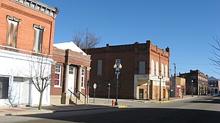
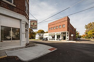
Liberty is a town in and the county seat of Union County, Indiana, United States, located about 5 miles (8.0 km) west of the state's border with Ohio. The population was 2,000 at the 2020 census.

<span class="mw-page-title-main">Meridian Hills, Indiana</span> Town in Indiana, United States

Meridian Hills is a town in Washington Township, Marion County, Indiana, about 8 miles (13 km) north of downtown Indianapolis. It had a population of 1,774 at the 2020 census, up from 1,616 in 2010.

<span class="mw-page-title-main">North Crows Nest, Indiana</span> Town in Indiana, United States

North Crows Nest is a town in Washington Township, Marion County, Indiana, United States. It is approximately 7 miles (11 km) north of downtown Indianapolis. The population was 44 at the 2020 census. It has existed as an "included town" since 1970, when it was incorporated into Indianapolis as part of Unigov. It is part of Indianapolis, but retains town governmental powers under IC 36-3-1-11.

<span class="mw-page-title-main">Warren Park, Indiana</span> Town in Indiana, United States

Warren Park is a town in Warren Township, Marion County, Indiana, United States. The population was 1,490 at the 2020 census. It has existed as an "included town" since 1970, when it was incorporated into Indianapolis as part of Unigov. It is part of Indianapolis, but retains a functioning town government under IC 36-3-1-11.

References

  1. "US Gazetteer files: 2010, 2000, and 1990". United States Census Bureau. February 12, 2011. Retrieved April 23, 2011.
  2. "2020 U.S. Gazetteer Files". United States Census Bureau. Retrieved March 16, 2022.
  3. 1 2 U.S. Geological Survey Geographic Names Information System: Vernon, Indiana
  4. 1 2 "U.S. Census website". United States Census Bureau . Retrieved January 31, 2008.
  5. "Find a County". National Association of Counties. Archived from the original on May 31, 2011. Retrieved June 7, 2011.
  6. Baker, Ronald L. (October 1995). From Needmore to Prosperity: Hoosier Place Names in Folklore and History . Indiana University Press. p.  334. ISBN   978-0-253-32866-3. ...named for Mount Vernon, the home of George Washington.
  7. "Jennings County". Jim Forte Postal History. Retrieved November 9, 2014.
  8. Boyer, Margrette (1912). "Morgan's Raid in Indiana". The Indiana Quarterly Magazine of History. 8 (4): 156–157. ISSN   0147-2259. JSTOR   27785388.
  9. Davis, Caroline (July 15, 2013). "The Raid Continues: Morgan's Raiders in Indiana".
  10. "G001 - Geographic Identifiers - 2010 Census Summary File 1". United States Census Bureau. Archived from the original on February 13, 2020. Retrieved July 25, 2015.
  11. "Census of Population and Housing". Census.gov. Retrieved June 4, 2015.
  12. "U.S. Census website". United States Census Bureau . Retrieved December 11, 2012.
  13. "Jessamyn West | American writer". Encyclopedia Britannica. Retrieved February 26, 2021.