Princeton, Indiana

Last updated

Princeton, Indiana
Gibson County Courthouse in Princeton.jpg
Southern and western sides of Princeton's best-known landmark, the 1884 Gibson County Courthouse
Nickname(s): 
The Heart of
Southwestern Indiana
Motto: 
"Creating A World Class Community" [1]
Gibson County Indiana Incorporated and Unincorporated areas Princeton Highlighted 1862046.svg
Location of Princeton in Gibson County, Indiana.
Coordinates: 38°21′17″N87°34′44″W / 38.35472°N 87.57889°W / 38.35472; -87.57889
CountryFlag of the United States.svg United States
StateFlag of Indiana.svg  Indiana
County Gibson
Township Patoka
Settled1814
Named for William Prince
Government
  MayorGreg Wright (R)
Area
[2]
  Total5.48 sq mi (14.19 km2)
  Land5.47 sq mi (14.18 km2)
  Water0.01 sq mi (0.01 km2)  0.20%
Elevation
[3]
459 ft (140 m)
Population
 (2020)
  Total8,301
  Density1,516.16/sq mi (585.39/km2)
Time zone UTC−6 (CST)
  Summer (DST) UTC−5 (CDT)
ZIP Code
47670
Area code 812
FIPS code 18-62046 [4]
GNIS feature ID2396277 [3]
U.S. Highways US 41.svg
Major State Roads Indiana 64.svg Indiana 65.svg
Website www.princeton.in.gov

Princeton is the largest city in and the county seat of Patoka Township, Gibson County, Indiana, United States. [5] The population was 8,301 at the 2020 United States Census, and it is part of the greater Evansville, Indiana, Metropolitan Area. [6]

Contents

History

In 1800, the Indiana Territory was created with Vincennes (Knox County) as its capital. The rich farmlands in the southwest of the territory with access to the Ohio River attracted many pioneers and settlers to the area, one of whom was an Irish immigrant named William Prince. Born in 1772, he immigrated to America at the age of 22. He later became a Gibson County Commissioner and the county seat of Princeton is named after him.

The year 1813 saw the move of the territorial capital east from Vincennes to Corydon and the creation of Gibson County. Gibson had previously been part of the vast Knox County which covered all the land of southwestern Indiana, bordered by the Wabash and Ohio Rivers. By early 1814, settlers to this area were asking for a "seat of justice," or county seat. Captain William Prince was one of four commissioners who located the seat at the half-way stand on the Evansville and Vincennes stage line. By drawing of lots, commissioners decided to name the town after Captain Prince. [7]

The iconic symbol of Princeton is the Gibson County Courthouse, a structure built in the Second Empire style. It has been featured as a collectible figurine by the Department 56 Original Snow Village. A post office was established in Princeton as early as 1816. The local newspaper, the Princeton Daily Clarion, was first published in 1846. Lyles Station, a small community just west of Princeton, was founded by freed Tennessee slave Joshua Lyles in 1849. It served as a haven for runaway slaves who braved the Ohio River on a northern trek towards freedom.

The Wabash and Erie Canal ran through the nearby towns of Francisco and Port Gibson, providing a means of reaching distant markets with goods from Princeton. The 1850s saw the advance of the railway system through Indiana, spelling doom for the canal system. The Evansville and Terre Haute Railroad line was run through town in 1852 and the Princeton Depot was constructed in 1875. The railroad became a boon to Princeton's industry as the Southern Railway Shops were constructed on the edge of town in 1892. Other industry included the Heinz plant (because of the area's famed tomatoes being good for ketchup making) and the Princeton Coal Mine.

In 1925, the Tri-State Tornado left its mark on the town. After hitting Griffin and narrowly missing Owensville to the southwest, the tornado devastated the southern side of Princeton, killing 44 people, injuring another 146 and leaving hundreds homeless. Princeton was the historic storm's final victim, as the tornado dissipated about 10 miles to the northeast near Petersburg. The deadliest tornado in US history claimed 95 lives in Indiana with almost half of those in Princeton. [8]


On 9 December 1926, twenty-nine people were killed in a mine explosion in or near Princeton. [9]

Toyota Motor Company opened a truck manufacturing plant between Princeton and Fort Branch in 1998 to build a new full-size pickup and SUV. Toyota significantly increased production at the plant in 2000. As of 2016, the plant builds two SUVs and a van.

On April 18, 2008, Princeton was shaken by the 2008 Illinois earthquake, epicentered approximately 18.5 miles (30 km) away near West Salem, Illinois.

The Gibson County Courthouse and Welborn-Ross House are listed on the National Register of Historic Places. [10]

Geography

According to the 2010 census, Princeton has a total area of 5.075 square miles (13.14 km2), of which 5.07 square miles (13.13 km2) (or 99.9%) is land and 0.005 square miles (0.01 km2) (or 0.1%) is water. [11]

Climate

The climate in this area is characterized by hot, humid summers and generally mild to cool winters. According to the Köppen climate classification system, Princeton has a humid subtropical climate, abbreviated "Cfa" on climate maps. [12]

Demographics

Princeton's Post Office, erected 1913 Princeton Post Office.jpg
Princeton's Post Office, erected 1913
Historical population
CensusPop.Note
1840 573
1850 80640.7%
1860 1,39773.3%
1870 1,84732.2%
1880 2,56638.9%
1890 3,07619.9%
1900 6,04196.4%
1910 6,4486.7%
1920 7,13210.6%
1930 7,5055.2%
1940 7,7863.7%
1950 7,673−1.5%
1960 7,9063.0%
1970 7,431−6.0%
1980 8,97620.8%
1990 8,127−9.5%
2000 8,1750.6%
2010 8,6445.7%
2020 8,301−4.0%
U.S. Decennial Census [13]

2020 census

In the 2020 census, [14] the population of Princeton was 8,301. There were 3,552 households. White population was 89.9%, of which 88.2% were not Hispanic or Latino; Black or African American alone 6.8%; two or more races 3.1%; Hispanic or Latino 1.7%; and Asian alone 0.1%.

2010 census

As of the census [15] of 2010, there were 8,644 people, 3,516 households, and 2,129 families living in the city. The population density was 1,704.9 inhabitants per square mile (658.3/km2). There were 3,976 housing units at an average density of 784.2 per square mile (302.8/km2). The racial makeup of the city was 90.4% White, 4.6% African American, 0.2% Native American, 0.7% Asian, 1.1% from other races, and 3.0% from two or more races. Hispanic or Latino of any race were 2.5% of the population.

There were 3,516 households, of which 32.8% had children under the age of 18 living with them, 41.0% were married couples living together, 15.1% had a female householder with no husband present, 4.5% had a male householder with no wife present, and 39.4% were non-families. 33.8% of all households were made up of individuals, and 14.1% had someone living alone who was 65 years of age or older. The average household size was 2.34 and the average family size was 2.99.

The median age in the city was 37.2 years. 25% of residents were under the age of 18; 8.9% were between the ages of 18 and 24; 25.5% were from 25 to 44; 24.6% were from 45 to 64; and 16.1% were 65 years of age or older. The gender makeup of the city was 47.7% male and 52.3% female.

2000 census

As of the census [4] of 2000, there were 8,175 people, 3,451 households, and 2,146 families living in the city. The population density was 1,703.1 inhabitants per square mile (657.6/km2). There were 3,806 housing units at an average density of 792.9 per square mile (306.1/km2). The racial makeup of the city was 91.36% White, 5.36% African American, 0.17% Native American, 1.26% Asian, 0.01% Pacific Islander, 0.39% from other races, and 1.44% from two or more races. Hispanic or Latino of any race were 1.13% of the population.

There were 3,451 households, out of which 28.9% had children under the age of 18 living with them, 44.1% were married couples living together, 13.8% had a female householder with no husband present, and 37.8% were non-families. 33.0% of all households were made up of individuals, and 15.9% had someone living alone who was 65 years of age or older. The average household size was 2.28 and the average family size was 2.88.

In the city, the age distribution of the population shows 24.1% under the age of 18, 8.8% from 18 to 24, 27.4% from 25 to 44, 20.6% from 45 to 64, and 19.1% who were 65 years of age or older. The median age was 38 years. For every 100 females, there were 87.2 males. For every 100 females age 18 and over, there were 83.0 males.

The median income for a household in the city was $26,689, and the median income for a family was $37,308. Males had a median income of $28,076 versus $19,825 for females. The per capita income for the city was $15,049. About 15.0% of families and 15.8% of the population were below the poverty line, including 23.2% of those under age 18 and 11.2% of those age 65 or over.

Economy

Toyota Motor Manufacturing Indiana is Princeton's largest employer Toyota Motor Manufacturing Indiana Front Entrance.jpg
Toyota Motor Manufacturing Indiana is Princeton's largest employer

Major employers in Princeton include Toyota Motor Manufacturing Indiana (TMMI), located 3 miles to the south, nearly halfway between Princeton and Fort Branch, where the Toyota Sequoia, Sienna and Highlander are manufactured; and Hansen Corporation. Many Toyota suppliers have facilities between the plant site and the city. These suppliers include EnovaPremier, Vuteq, TBIN, Millennium Steel, DXE, SMC, Global SQ, and Trigo. All of these facilities were either built or converted from other uses to furnish supplies, part and services to TMMI. Siemens at one point had research and manufacturing facilities in Princeton, but the manufacturing plant was closed in the early 1990s and the research facility was closed soon after. A large hardware store currently occupies the former Siemens site.

Toyota's announcement in late 1995 that it would be building a $1 billion manufacturing facility in Princeton created an economic boom, as many of Toyota's suppliers also built plants in or near Princeton to minimize shipping and logistical expenses. Additionally, many service businesses located in town to satisfy the needs of the employees, many of whom would be relocating to the Princeton area from elsewhere. However, the arrival of Toyota was not without controversy. Many objected to the ten-year tax abatement offered as part of the incentive package to induce Toyota to locate in the area, and others were worried by the fact that it would likely not be unionized (as of 2023, it is not).

More recently, many retail and restaurant chains have opened locations in Princeton. Analysts attribute much of this to the planned extension of Interstate 69—at the time many of these businesses were sited in Princeton, the leading proposal for the project was to upgrade U.S. 41 (it was later decided to build Interstate 69 over a new-terrain route, which would travel between nearby Oakland City and Francisco).

Princeton is served by two freight rail lines: CSX and Norfolk Southern. For people who enjoy watching trains online, Virtual Railfan, via YouTube, provides northbound and southbound cams along the tracks at W. Broadway St. for 24-hour viewing when the cameras are in operation. The cams are hosted by the Gibson County Visitors and Tourism Bureau. Greyhound Bus Lines stops at curbside to pick up and discharge passengers outside a Burger King restaurant at 2740 W. Broadway St.

Government

Princeton Municipal Building Princeton Municipal Building.jpg
Princeton Municipal Building

Princeton is governed by a mayor and a five-member city council, all of whom are elected for four-year terms. The current mayor is Greg Wright, Republican as of January 1, 2020. City functions are divided among the Police Department, Sanitation Department, Parks and Recreation Department, Street Department, Sewer Department, Water Department, Water Treatment Plant, and the Princeton Fire Territory (formed from a merger between the Princeton Fire Department and the Patoka Township Fire Department in early 2006).

Parks and recreation

Lafayette Park Lafayette Park - Princeton, Indiana.jpg
Lafayette Park

Princeton has three main city parks, administered by the Department of Parks and Recreation. Lafayette Park, on the city's north side, is the largest. It features a fishing pond, shelter houses, a playground, an open general-purpose recreation area, and a stage for public performances. The city swimming pool is adjacent to Lafayette Park, as is Kiddie Land, a playground for very young children. Gil Hodges field, where the Princeton Community High School baseball team plays its home games, is also located on the park property.

Gibson County Fairgrounds Gibson County Fairgrounds.jpg
Gibson County Fairgrounds

The other two city parks are South Side Park and East End Park

Media

Radio
Newspapers

Education

The town has a lending library, the Princeton Public Library. [16]

Notable people

Highways

Major roads

Sister City

Related Research Articles

<span class="mw-page-title-main">Gibson County, Indiana</span> County in Indiana, United States

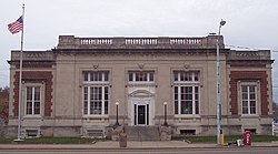
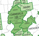
Gibson County is a county in the southwestern part of the U.S. state of Indiana. As of the 2020 United States Census, the population was 33,011. The county seat is Princeton.

<span class="mw-page-title-main">Mount Carmel, Illinois</span> City in Illinois, United States

Mount Carmel is a city in and the county seat of Wabash County, Illinois, United States. At the time of the 2010 census, the population was 7,284, and it is the largest city in the county. The next largest town in Wabash County is Allendale, population 475.

<span class="mw-page-title-main">Edinburgh, Indiana</span> City in Indiana, United States

Edinburgh is a town in Bartholomew, Johnson, and Shelby counties in the U.S. state of Indiana. The population was 4,480 at the 2010 census. It is part of the Columbus, Indiana metropolitan statistical area. Edinburgh was named in honor of Edinburgh, Scotland and for many years was pronounced the same way.

<span class="mw-page-title-main">Fort Branch, Indiana</span> Town in Indiana, United States

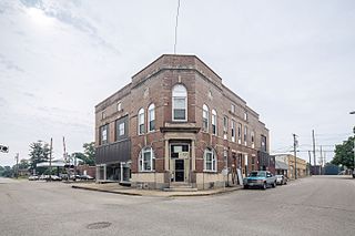
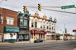
Fort Branch is the largest town and 2nd largest community in Gibson County, Indiana after Princeton. The population was 2,965 at the 2020 census. It is part of the Evansville, Indiana, Metropolitan Area.

<span class="mw-page-title-main">Francisco, Indiana</span> Town in Indiana, United States

Francisco is the fifth largest town and seventh largest community in Gibson County, Indiana, United States. A town in Center Township, the population was 469 at the 2010 census and was founded in 1851. Local tradition says the town was named for its first settler, a Spanish laborer working on the Wabash and Erie Canal who built a shack in the area. It is part of the Evansville, Indiana, Metropolitan Area.

<span class="mw-page-title-main">Haubstadt, Indiana</span> Town in Indiana, United States

Haubstadt is the second largest town, after Fort Branch, and fourth largest community in Gibson County, Indiana, United States. The population was 1,638 at the 2020 census. Haubstadt has recently become a bedroom community of Evansville and such, is part of the Evansville, Indiana, Metropolitan Area.

<span class="mw-page-title-main">Mackey, Indiana</span> Town in Indiana, United States

Mackey is a town in Barton Township, Gibson County, Indiana, United States. With a population of 106 at the 2010 census, Mackey is the smallest incorporated community in Gibson County and one of the smallest incorporated communities in the state.

<span class="mw-page-title-main">Oakland City, Indiana</span> City in Indiana, United States

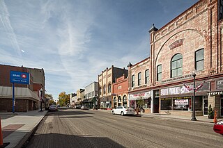
Oakland City is the second-largest city, but third largest community in Gibson County, Indiana, United States, after Princeton and the town of Fort Branch. It is the site of Oakland City University. The population was 2,279 at the 2020 census.

<span class="mw-page-title-main">Owensville, Indiana</span> Town in Indiana, United States

Owensville is the third largest town and the smallest of the five larger communities in Gibson County, Indiana, United States. The population was 1,338 in 2020.

<span class="mw-page-title-main">Somerville, Indiana</span> Town in Indiana, United States

Somerville is a town in Barton Township, Gibson County, Indiana, United States. The population was 293 at the 2010 census, making it the third-smallest community in the county.

<span class="mw-page-title-main">Pendleton, Indiana</span> Town in Indiana, United States

Pendleton is a town in Fall Creek Township, Madison County, Indiana, United States. The population was 4,717 at the 2020 census, up from 4,253 in 2010.

<span class="mw-page-title-main">Kendallville, Indiana</span> City in Indiana, United States

Kendallville is a city in Wayne Township, Noble County, in the U.S. state of Indiana. The population was 10,205 at the 2021 census.

<span class="mw-page-title-main">Osceola, Indiana</span> Town in Indiana, United States

Osceola is a town in Penn Township, St. Joseph County, in the U.S. state of Indiana. The population was 2,463 at the 2010 Census. It is part of the South Bend–Mishawaka, IN-MI, Metropolitan Statistical Area.

<span class="mw-page-title-main">Wabash, Indiana</span> City in Indiana, United States

Wabash is a city in Noble Township, Wabash County, in the U.S. state of Indiana. The population was 10,666 at the 2010 census. The city is situated along the Wabash River in the county seat of Wabash County.

<span class="mw-page-title-main">Monticello, Indiana</span> City in Indiana, United States

Monticello is a city in Union Township, White County, Indiana, United States. The city is the county seat of White County. The population was 5,508 at the 2020 census.

<span class="mw-page-title-main">Princeton, Massachusetts</span> Town in Massachusetts, United States

Princeton is a town in Worcester County, Massachusetts, United States. It is bordered on the east by Sterling and Leominster, on the north by Westminster, on the northwest by Hubbardston, on the southwest by Rutland, and on the southeast by Holden. The preeminent landmark within Princeton is Mount Wachusett, which straddles the line between Princeton and Westminster but the entrance to which is within Princeton. According to tradition, in 1675, Mary Rowlandson was ransomed upon Redemption Rock, now within the town of Princeton, by King Philip. The population was 3,495 at the 2020 census. Princeton is a rural exurb, serving as a bedroom commuter town for nearby cities such as Worcester, Gardner, and Boston.

<span class="mw-page-title-main">Bradford, Tennessee</span> Town in Tennessee, United States

Bradford is a town in Gibson County, Tennessee, United States. The population was 1,048 at the 2010 census.

<span class="mw-page-title-main">Princeton, Minnesota</span> City in Minnesota, United States

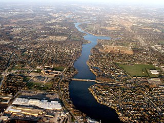
Princeton is a city in Mille Lacs and Sherburne counties in the U.S. state of Minnesota, at the junction of the Rum River and its West Branch. It is 50 miles (80 km) north of Minneapolis and 30 miles (48 km) east of St. Cloud, at the intersection of Highways 169 and 95. The population was 4,819 at the 2020 census and an estimated 5,311 in 2022. A majority of its residents live in Mille Lacs County.

<span class="mw-page-title-main">Oak Grove, Jackson County, Missouri</span> City in Missouri, United States

Oak Grove is a city in Jackson and Lafayette counties in the U.S. state of Missouri. The population was 8,157 at the 2020 census. It is part of the Kansas City metropolitan area.

<span class="mw-page-title-main">Princeton, Wisconsin</span> City in Wisconsin, United States

Princeton is a city in western part of Green Lake County, Wisconsin, United States. The population was 1,214 at the 2010 census. The city is located within the Town of Princeton. The Fox River flows through the city, dividing the city into an east half and west half.

References

  1. "The City of Princeton Indiana". The City of Princeton Indiana. Retrieved September 29, 2012.
  2. "2020 U.S. Gazetteer Files". United States Census Bureau. Retrieved March 16, 2022.
  3. 1 2 U.S. Geological Survey Geographic Names Information System: Princeton, Indiana
  4. 1 2 "U.S. Census website". United States Census Bureau . Retrieved January 31, 2008.
  5. "Find a County". National Association of Counties. Retrieved June 7, 2011.
  6. "Profile for Princeton, Indiana, Indiana". ePodunk. Archived from the original on May 15, 2019. Retrieved September 29, 2012.
  7. "History of Gibson County Indiana". Archived from the original on February 21, 2010. Retrieved July 19, 2009.
  8. Mason, Angela (2011). Death Rides the Sky: The Story of the 1925 Tri-State Tornado. Rockford, IL: Black Oak Media. ISBN   978-1-61876-001-2. p. 294
  9. ""Disasters"". Powell Valley News. January 7, 1927. Retrieved August 21, 2023.
  10. "National Register Information System". National Register of Historic Places . National Park Service. July 9, 2010.
  11. "G001 - Geographic Identifiers - 2010 Census Summary File 1". United States Census Bureau. Archived from the original on February 13, 2020. Retrieved July 29, 2015.
  12. Climate Summary for Princeton, Indiana
  13. "Census of Population and Housing". Census.gov. Retrieved June 4, 2015.
  14. "U.S. Census website" . Retrieved October 16, 2021.
  15. "U.S. Census website". United States Census Bureau . Retrieved December 11, 2012.
  16. "Indiana public library directory" (PDF). Indiana State Library. Retrieved March 7, 2018.
  17. "Gen. Poland Dead". Pharos-Tribune . Logansport, IN. August 9, 1898. p. 1 via Newspapers.com.