Brownstown, Indiana

Last updated

Brownstown, Indiana
BrownstownINHistoricMainStreet.JPG
Historic Downtown Main Street
Jackson County Indiana Incorporated and Unincorporated areas Brownstown Highlighted 1808470.svg
Location of Brownstown in Jackson County, Indiana.
Coordinates: 38°52′40″N86°02′48″W / 38.87778°N 86.04667°W / 38.87778; -86.04667
Country United States
State Indiana
County Jackson
Township Brownstown
Area
[1]
  Total1.62 sq mi (4.21 km2)
  Land1.62 sq mi (4.19 km2)
  Water0.01 sq mi (0.01 km2)
Elevation
[2]
656 ft (200 m)
Population
 (2020)
  Total3,025
  Density1,868.44/sq mi (721.59/km2)
Time zone UTC-5 (EST)
  Summer (DST) UTC-5 (EST)
ZIP code
47220
Area code 812
FIPS code 18-08470 [3]
GNIS feature ID2396612 [2]
Website https://www.explorebrownstown.com/

Brownstown is a town within Brownstown Township and the county seat of Jackson County, Indiana, United States. [4] The population was 2,947 at the 2010 census. It was named for Jacob Brown, a general of the War of 1812. [5]

Contents

History

Jackson County Courthouse Jackson County Courthouse in Brownstown, southern side and front.jpg
Jackson County Courthouse

The town of Brownstown was platted on April 8, 1816, notably prior to the statehood of Indiana itself. [6] Brownstown became the county seat of Jackson County in November 1816, replacing Fort Vallonia, which had only been the county seat since June of that year. The land for the Jackson County Court House, which rests in the heart of Brownstown on the square, was donated by Col. John Ketcham (1782–1865) for this specific function.

The Jackson County Courthouse was listed on the National Register of Historic Places in 2011. [7]

Geography

According to the 2010 census, Brownstown has a total area of 1.6 square miles (4.14 km2), of which 1.59 square miles (4.12 km2) (or 99.38%) is land and 0.01 square miles (0.03 km2) (or 0.63%) is water. [8]

Brownstown lies on the East Fork of the White River, bordered by the Jackson-Washington State Forest and near the Hoosier National Forest.

Demographics

Historical population
CensusPop.Note
1860 504
1870 57213.5%
1880 84948.4%
1890 1,42267.5%
1900 1,68518.5%
1910 1,492−11.5%
1920 1,5544.2%
1930 1,75813.1%
1940 1,8605.8%
1950 1,9987.4%
1960 2,1588.0%
1970 2,37610.1%
1980 2,70413.8%
1990 2,8726.2%
2000 2,9783.7%
2010 2,947−1.0%
2020 3,0252.6%
U.S. Decennial Census [9]

2010 census

As of the census [10] of 2010, there were 2,947 people, 1,175 households, and 792 families living in the town. The population density was 1,853.5 inhabitants per square mile (715.6/km2). There were 1,282 housing units at an average density of 806.3 per square mile (311.3/km2). The racial makeup of the town was 98.3% White, 0.1% African American, 0.3% Native American, 0.2% Asian, 0.1% Pacific Islander, 0.3% from other races, and 0.8% from two or more races. Hispanic or Latino of any race were 1.0% of the population.

There were 1,175 households, of which 34.7% had children under the age of 18 living with them, 48.3% were married couples living together, 15.0% had a female householder with no husband present, 4.2% had a male householder with no wife present, and 32.6% were non-families. 29.0% of all households were made up of individuals, and 14.8% had someone living alone who was 65 years of age or older. The average household size was 2.42 and the average family size was 2.97.

The median age in the town was 38.7 years. 25.7% of residents were under the age of 18; 8% were between the ages of 18 and 24; 24.2% were from 25 to 44; 23.5% were from 45 to 64; and 18.6% were 65 years of age or older. The gender makeup of the town was 48.2% male and 51.8% female.

2000 census

As of the census [3] of 2000, there were 3,000 people, 1,168 households, and 805 families living in the town. The population density was 2,080.6 inhabitants per square mile (803.3/km2). There were 1,242 housing units at an average density of 867.7 per square mile (335.0/km2). The racial makeup of the town was 98.76% White, 0.10% African American, 0.24% Native American, 0.24% Asian, 0.10% Pacific Islander, 0.07% from other races, and 0.50% from two or more races. Hispanic or Latino of any race were 0.60% of the population.

There were 1,168 households, out of which 34.6% had children under the age of 18 living with them, 49.7% were married couples living together, 16.4% had a female householder with no husband present, and 31.0% were non-families. 28.0% of all households were made up of individuals, and 14.0% had someone living alone who was 65 years of age or older. The average household size was 2.43 and the average family size was 2.96.

In the town, the population was spread out, with 26.8% under the age of 18, 8.8% from 18 to 24, 27.8% from 25 to 44, 19.4% from 45 to 64, and 17.3% who were 65 years of age or older. The median age was 36 years. For every 100 females, there were 85.1 males. For every 100 females age 18 and over, there were 76.7 males.

The median income for a household in the town was $35,000, and the median income for a family was $39,044. Males had a median income of $27,984 versus $21,503 for females. The per capita income for the town was $15,525. About 8.9% of families and 11.7% of the population were below the poverty line, including 18.0% of those under age 18 and 6.2% of those age 65 or over.

Education

The town has a lending library, the Brownstown Public Library, along with three main public schools: an elementary, middle, and high school. [11] The town also has a private Lutheran elementary and middle school.

Related Research Articles

<span class="mw-page-title-main">Brownstown, Cambria County, Pennsylvania</span> Borough in Pennsylvania, United States

Brownstown is a borough in Cambria County, Pennsylvania, United States. The population was 744 at the 2010 census. It is part of the Johnstown, Pennsylvania Metropolitan Statistical Area and also part of Johnstown's urban area.

<span class="mw-page-title-main">Jackson County, Indiana</span> County in Indiana, United States

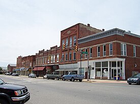
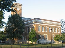
Jackson County is a county located in the U.S. state of Indiana. As of 2020, the population was 46,428. The county seat is Brownstown.

<span class="mw-page-title-main">Dillsboro, Indiana</span> Town in Indiana, United States

Dillsboro is a town in Clay Township, Dearborn County, Indiana, United States. As of 2020, the population is 1,360.

<span class="mw-page-title-main">Greendale, Indiana</span> City in Indiana, United States

Greendale is a city in Dearborn County, Indiana, United States. The population was 4,520 at the 2010 census.

<span class="mw-page-title-main">Moores Hill, Indiana</span> Town in Indiana, United States

Moores Hill is a town in Sparta Township, Dearborn County, Indiana, United States. The population was 597 at the 2010 census.

<span class="mw-page-title-main">West Harrison, Indiana</span> Town in Indiana, United States

West Harrison is a town in Harrison Township, Dearborn County, Indiana, United States. The population was 289 at the 2010 census.

<span class="mw-page-title-main">Andrews, Indiana</span> Town in Indiana, United States

Andrews is a town in Dallas Township, Huntington County, Indiana, United States. The population was 1,048 at the 2020 census.

<span class="mw-page-title-main">Roanoke, Indiana</span> Town in Indiana, United States

Roanoke is a town in Jackson Township, Huntington County, Indiana, United States. The population was 1,762 at the 2020 census. Roanoke is governed by a town council. Town offices include the clerk treasurer, utilities department, police department, and volunteer fire department. The town has a public elementary school. WOWO and WRNP have transmitter towers in Roanoke, along U.S. Highway 24. For many years, television station WPTA was licensed to Roanoke, though that station's studios and transmitter have always been located in nearby Fort Wayne.

<span class="mw-page-title-main">Medora, Indiana</span> Town in Indiana, United States

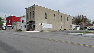
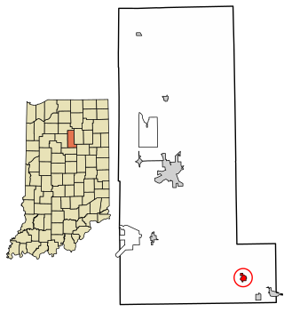
Medora is a town in Carr Township, Jackson County, Indiana, United States. The population was 693 at the 2010 census.

<span class="mw-page-title-main">Prince's Lakes, Indiana</span> Town in Indiana, United States

Prince's Lakes is a town in Nineveh Township, Johnson County, Indiana, United States. The population was 1,312 at the 2010 census.

<span class="mw-page-title-main">Sidney, Indiana</span> Town in Indiana, United States

Sidney is a town in Jackson Township, Kosciusko County, in the U.S. state of Indiana. The population was 83 at the 2010 census.

<span class="mw-page-title-main">Edgewood, Indiana</span> Town in Indiana, United States

Edgewood is a town in Anderson Township, Madison County, Indiana, United States. It is part of the Indianapolis–Carmel–Anderson metropolitan statistical area. The population was 2,053 at the 2020 census.

<span class="mw-page-title-main">Ingalls, Indiana</span> Town in Indiana, United States

Ingalls is a town in Green Township, Madison County, Indiana, United States. It is part of the Indianapolis–Carmel–Anderson metropolitan statistical area. The population was 2,223 at the 2020 census.

<span class="mw-page-title-main">Amboy, Indiana</span> Town in Indiana, United States

Amboy is a town in Jackson Township, Miami County, in the U.S. state of Indiana. The population was 317 at the 2020 census, down from 384 in 2010.

<span class="mw-page-title-main">Morgantown, Indiana</span> Town in Indiana, United States

Morgantown is a town at the intersection of Indiana state routes 135 and 252 in Jackson Township, Morgan County, in the U.S. state of Indiana. The population was 1,014 at the 2020 census.

<span class="mw-page-title-main">Versailles, Indiana</span> Town in Indiana, United States

Versailles is a town in Johnson Township, Ripley County, in the U.S. state of Indiana. The population was 2,113 at the 2010 census. The town is the county seat of Ripley County.

<span class="mw-page-title-main">East Germantown, Indiana</span> Town in Indiana, United States

East Germantown is a town in Jackson Township, Wayne County, in the U.S. state of Indiana. The population was 410 at the 2010 census.

<span class="mw-page-title-main">Brookston, Indiana</span> Town in Indiana, United States

Brookston is a town in Prairie Township, White County, in the U.S. state of Indiana. The population was 1,554 as of the 2010 United States Census.

<span class="mw-page-title-main">Burnettsville, Indiana</span> Town in Indiana, United States

Burnettsville is a town in Jackson Township, White County, in the U.S. state of Indiana. The population was 346 at the 2010 census.

<span class="mw-page-title-main">Reynolds, Indiana</span> Town in Indiana, United States

Reynolds is a town in Honey Creek Township, White County, in the U.S. state of Indiana. The population was 533 at the 2010 census.

References

  1. "2020 U.S. Gazetteer Files". United States Census Bureau. Retrieved March 16, 2022.
  2. 1 2 U.S. Geological Survey Geographic Names Information System: Brownstown, Indiana
  3. 1 2 "U.S. Census website". United States Census Bureau . Retrieved January 31, 2008.
  4. "Find a County". National Association of Counties. Archived from the original on May 31, 2011. Retrieved June 7, 2011.
  5. History of Jackson County, Indiana: From the Earliest Time to the Present, with Biographical Sketches, Notes, Etc., Together with an Extended History of the Northwest, the Indiana Territory and the State of Indiana. Unigraphic. 1886. p. 362.
  6. History of Jackson County, Indiana: From the Earliest Time to the Present, with Biographical Sketches, Notes, Etc., Together with an Extended History of the Northwest, the Indiana Territory and the State of Indiana. Unigraphic. 1886. p. 500.
  7. "National Register of Historic Places Listings". Weekly List of Actions Taken on Properties: 12/12/11 through 12/16/112. National Park Service. November 23, 2011.
  8. "G001 - Geographic Identifiers - 2010 Census Summary File 1". United States Census Bureau. Archived from the original on February 13, 2020. Retrieved July 13, 2015.
  9. "Census of Population and Housing". Census.gov. Retrieved June 4, 2015.
  10. "U.S. Census website". United States Census Bureau . Retrieved December 11, 2012.
  11. "Indiana public library directory" (PDF). Indiana State Library. Archived from the original (PDF) on February 18, 2017. Retrieved March 7, 2018.