Lawrenceburg, Indiana

Last updated

Lawrenceburg, Indiana
Walnut Street, Lawrenceburg, IN (48369751716).jpg
Walnut Street in Downtown Lawrenceburg
Dearborn County Indiana Incorporated and Unincorporated areas Lawrenceburg Highlighted 1842462.svg
Location of Lawrenceburg in Dearborn County, Indiana.
Coordinates: 39°07′06″N84°53′06″W / 39.11833°N 84.88500°W / 39.11833; -84.88500
Country United States
State Indiana
County Dearborn
Government
   Mayor Paddrick Libbert (R)
Area
[1]
  Total5.55 sq mi (14.37 km2)
  Land5.29 sq mi (13.69 km2)
  Water0.26 sq mi (0.68 km2)  5.18%
Elevation
[2]
784 ft (239 m)
Population
 (2020)
  Total5,129
  Density970.30/sq mi (374.67/km2)
Time zone UTC-5 (EST)
  Summer (DST) UTC-4 (EDT)
ZIP code
47025
Area code 812
FIPS code 18-42462 [3]
GNIS feature ID2395648 [2]
Website lawrenceburg-in.com

Lawrenceburg is a city and the county seat of Dearborn County, Indiana, United States. The population was 5,129 at the 2020 census. It is the largest city in Dearborn County. [4] [5] Lawrenceburg is in southeast Indiana, on the Ohio River west of Cincinnati.

Contents

History

Founded in 1802, Lawrenceburg was named for the maiden name of the wife of founder Samuel C. Vance. [5]

In the 19th century, Lawrenceburg became an important trading center for riverboats on the Ohio River. [6]

The Dearborn County Courthouse, Downtown Lawrenceburg Historic District, Hamline Chapel United Methodist Church, the Liberty Theatre, the Dunn Home, The Daniel S. Major House, and Vance-Tousey House are listed on the National Register of Historic Places. [7]

Geography

The City of Lawrenceburg is located in the Ohio River Valley and is situated on the banks of the Ohio River. Lawrenceburg is located on the west side of the Greater Cincinnati, Ohio tri-state metro area. [8]

According to the 2010 census, Lawrenceburg has a total area of 5.21 square miles (13.49 km2), of which 4.94 square miles (12.79 km2) (or 94.82%) is land and 0.27 square miles (0.70 km2) (or 5.18%) is water. [9]

Demographics

Historical population
CensusPop.Note
1850 2,651
1870 3,159
1880 4,66847.8%
1890 4,284−8.2%
1900 4,3261.0%
1910 3,930−9.2%
1920 3,466−11.8%
1930 4,07217.5%
1940 4,4138.4%
1950 4,8068.9%
1960 5,0044.1%
1970 4,636−7.4%
1980 4,403−5.0%
1990 4,375−0.6%
2000 4,6857.1%
2010 5,0427.6%
2020 5,1291.7%
U.S. Decennial Census [10]

2010 census

As of the census [11] of 2010, there were 5,042 people, 2,057 households, and 1,142 families living in the city. The population density was 1,020.6 inhabitants per square mile (394.1/km2). There were 2,313 housing units at an average density of 468.2 per square mile (180.8/km2). The racial makeup of the city was 93.5% White, 3.0% African American, 0.3% Native American, 0.8% Asian, 0.3% from other races, and 2.2% from two or more races. Hispanic or Latino of any race were 1.2% of the population.

There were 2,057 households, of which 31.3% had children under the age of 18 living with them, 31.4% were married couples living together, 17.8% had a female householder with no husband present, 6.3% had a male householder with no wife present, and 44.5% were non-families. 39.1% of all households were made up of individuals, and 13.5% had someone living alone who was 65 years of age or older. The average household size was 2.26 and the average family size was 2.96.

The median age in the city was 35.5 years. 24.1% of residents were under the age of 18; 10.6% were between the ages of 18 and 24; 26.6% were from 25 to 44; 24.1% were from 45 to 64; and 14.7% were 65 years of age or older. The gender makeup of the city was 49.0% male and 51.0% female.

2000 census

As of the census [3] of 2000, there were 4,685 people, 1,914 households, and 1,140 families living in the city. The population density was 956.1 inhabitants per square mile (369.2/km2). There were 2,162 housing units at an average density of 441.2 per square mile (170.3/km2). The racial makeup of the city was 93.81% White. The two largest ethnic groups in Lawrenceburg and Lawrenceburg Township are 29% German Americans, and 19% Irish Americans, 4.18% African American, 0.15% Native American, 0.45% Asian, 0.04% Pacific Islander, 0.32% from other races, and 1.05% from two or more races. Hispanic or Latino of any race were 0.85% of the population.

There were 1,914 households, of which 31.0% had children under the age of 18 living with them, 36.2% were married couples living together, 18.4% had a female householder with no husband present, and 40.4% were non-families. 34.4% of all households were made up of individuals, and 13.5% had someone living alone who was 65 years of age or older. The average household size was 2.28 and the average family size was 2.94.

In the city, the population was spread out, with 24.2% under the age of 18, 11.5% from 18 to 24, 28.3% from 25 to 44, 20.1% from 45 to 64, and 15.8% who were 65 years of age or older. The median age was 35 years. For every 100 females, there were 88.5 males. For every 100 females age 18 and over, there were 86.4 males.

The median income for a household in the city was $29,306, and the median income for a family was $37,978. Males had a median income of $31,543 versus $21,985 for females. The per capita income for the city was $15,656. About 10.3% of families and 14.9% of the population were below the poverty line, including 17.9% of those under age 18 and 23.8% of those age 65 or over.

Economy

Industry

Tanner's Creek Generating Station and the city of Lawrenceburg Lawrenceburg-indiana-from-above.jpg
Tanner's Creek Generating Station and the city of Lawrenceburg

Lawrenceburg was home to the Tanner's Creek Generating Station, now AEP (Tanner's Creek Generating Station has been demolished).

Lawrenceburg has had a long history with whiskey production, earning the city the nickname Whiskey City, U.S.A. MGP Indiana, formerly Seagram's, operates within Lawrenceburg, and distills various alcoholic spirits.

Another industry located within Lawrenceburg is Anchor Glass Container (formerly Thatcher Glass).

Lawrenceburg is also home to Perfect North Slopes, a ski area located off Route 1. It boasts hills for skiing, snowboarding, and snowing tubing. It has been family owned and operated by the Perfect Family for many years and is open throughout the winter months (weather permitting).

Hollywood Casino Lawrenceburg (formerly Argosy Casino) is found in Lawrenceburg, and is the closest Indiana riverboat casino to downtown Cincinnati.

Education

The Lawrenceburg School District consists of the Lawrenceburg Primary School, Central Elementary, Greendale Middle School, Lawrenceburg Highschool and St. Lawrence Catholic School.

The city has a free lending library, the Lawrenceburg Public Library District. [12] Lawrenceburg residents may also obtain a library card at the Aurora Public Library in Aurora. [13]

Notable people

Lawrenceburg Public Library Lawrenceburg Public Library 2017.jpg
Lawrenceburg Public Library

See also

Related Research Articles

<span class="mw-page-title-main">Ohio County, Indiana</span> County in Indiana, United States

Ohio County is a county located in southeastern Indiana. With a 2020 population of 5,940, and an area of just 87 square miles, Ohio County is the smallest county in Indiana by area and the least populous. The county seat and only incorporated municipality is Rising Sun. The county was officially established in 1844 and was one of the last Indiana counties to be created. Ohio County borders the state of Kentucky across the Ohio River for which it was named. It is part of the Cincinnati, OH-KY-IN Metropolitan Statistical Area. The county is divided into four townships which provide local services. Three state roads pass through or into the county.

<span class="mw-page-title-main">Dearborn County, Indiana</span> County in Indiana, United States

Dearborn County is one of 92 counties of the U.S. state of Indiana. Located on the Ohio border near the southeast corner of the state, Dearborn County was formed in 1803 from a portion of Hamilton County, Ohio. In 2020, the population was 50,679. The county seat and largest city is Lawrenceburg. Dearborn County is part of the Cincinnati, OH-KY-IN Metropolitan Statistical Area.

<span class="mw-page-title-main">Aurora, Indiana</span> City in Indiana, United States

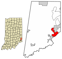
Aurora is a city in Center Township, Dearborn County, Indiana, United States. The population was 3,750 at the 2010 census.

<span class="mw-page-title-main">Bright, Indiana</span> Census-designated place in Indiana, United States

Bright is an unincorporated community and census-designated place (CDP) in Dearborn County, Indiana, United States. The population was 5,814 at the 2020 census.

<span class="mw-page-title-main">Dillsboro, Indiana</span> Town in Indiana, United States

Dillsboro is a town in Clay Township, Dearborn County, Indiana, United States. As of 2020, the population is 1,360.

<span class="mw-page-title-main">Greendale, Indiana</span> City in Indiana, United States

Greendale is a city in Dearborn County, Indiana, United States. The population was 4,520 at the 2010 census.

<span class="mw-page-title-main">Hidden Valley, Indiana</span> Census-designated place in Indiana, United States

Hidden Valley is a private residential community in Dearborn County, Indiana, United States. For statistical purposes it is a census-designated place (CDP), with a population of 5,387 at the 2010 census, up from 4,417 at the 2000 census.

<span class="mw-page-title-main">West Harrison, Indiana</span> Town in Indiana, United States

West Harrison is a town in Harrison Township, Dearborn County, Indiana, United States. The population was 289 at the 2010 census.

<span class="mw-page-title-main">Mitchell, Indiana</span> City in Indiana, United States

Mitchell is a city in Marion Township, Lawrence County, Indiana, United States. The population was 4,350 at the 2010 census.

<span class="mw-page-title-main">Rising Sun, Indiana</span> City in Indiana, United States

Rising Sun is a city in Randolph Township and the county seat of Ohio County, Indiana, United States, along the Ohio River. It is also the only incorporated community in the county. The population of Rising Sun was 2,304 at the 2010 census.

<span class="mw-page-title-main">Tell City, Indiana</span> City in Indiana, United States

Tell City is a city in Troy Township, Perry County, in the U.S. state of Indiana. It is located along the Ohio River. The population was 7,506 at the 2020 census. The city is the county seat of Perry County.

<span class="mw-page-title-main">Union City, Indiana</span> City in Indiana, United States

Union City is a city in Wayne Township, Randolph County, Indiana, United States. As of the 2020 census, the city had a population of 3,454.

<span class="mw-page-title-main">Osgood, Indiana</span> Town in Indiana, United States

Osgood is a town in Center Township, Ripley County, in the U.S. state of Indiana. The population was 1,624 at the 2010 census.

<span class="mw-page-title-main">Grandview, Indiana</span> Town in Indiana, United States

Grandview is a town in Hammond Township, Spencer County, Indiana, along the Ohio River. The population was 749 at the 2010 census.

<span class="mw-page-title-main">Harrison, Ohio</span> City in Ohio, United States

Harrison is a city in western Hamilton County, Ohio, United States. The population was 12,563 at the 2020 census. It is part of the Cincinnati metropolitan area.

<span class="mw-page-title-main">St. Bernard, Ohio</span> Village in Ohio, United States

St. Bernard is a village in Hamilton County, Ohio, United States. It is an enclave and suburb of Cincinnati. The population was 4,070 at the 2020 census.

<span class="mw-page-title-main">Miami Township, Hamilton County, Ohio</span> Township in Ohio, United States

Miami Township is one of the twelve townships of Hamilton County, Ohio, United States. The population was 15,969 as of the 2020 census.

<span class="mw-page-title-main">Whitewater Township, Hamilton County, Ohio</span> Township in Ohio, United States

Whitewater Township is one of the twelve townships of Hamilton County, Ohio, United States. The population was 6,375 as of the 2020 census.

<span class="mw-page-title-main">Hagerstown, Indiana</span> Town in Indiana, United States

Hagerstown is a town in Jefferson Township, Wayne County, in the U.S. state of Indiana. As of the 2020 census, the population was 1,681.

<span class="mw-page-title-main">Shawnee, Hamilton County, Ohio</span> Census-designated place in Ohio, United States

Shawnee is a census-designated place (CDP) in Miami Township, Hamilton County, Ohio, United States, 21 miles (34 km) west of downtown Cincinnati. The population of Shawnee was 747 at the 2020 census.

References

  1. "2020 U.S. Gazetteer Files". United States Census Bureau. Retrieved March 16, 2022.
  2. 1 2 U.S. Geological Survey Geographic Names Information System: Lawrenceburg, Indiana
  3. 1 2 "U.S. Census website". United States Census Bureau . Retrieved January 31, 2008.
  4. "Find a County". National Association of Counties. Retrieved June 7, 2011.
  5. 1 2 "Profile for Lawrenceburg, Indiana, IN". ePodunk. Archived from the original on February 9, 2013. Retrieved September 26, 2012.
  6. Stall, Sam (November 2001). "Liquid Asset". Cincinnati Magazine. p. 56. Retrieved May 15, 2013.
  7. "National Register Information System". National Register of Historic Places . National Park Service. July 9, 2010.
  8. Groh, Brian (October 23, 2020). "Opinion: The Radicalization of a Small American Town". The New York Times. ISSN   0362-4331 . Retrieved October 24, 2020.
  9. "G001 - Geographic Identifiers - 2010 Census Summary File 1". United States Census Bureau. Archived from the original on February 13, 2020. Retrieved July 29, 2015.
  10. "Census of Population and Housing". Census.gov. Retrieved June 4, 2015.
  11. "U.S. Census website". United States Census Bureau . Retrieved December 11, 2012.
  12. "Indiana public library directory" (PDF). Indiana State Library. Retrieved March 4, 2018.
  13. "FAQ". Aurora Public Library District. October 12, 2015. Retrieved March 4, 2018.
  14. "Nevada Governor Henry Goode Blasdel". National Governors Association. Retrieved September 26, 2012.
  15. "Secrets of A Master Builder". PBS. Retrieved September 26, 2012.
  16. "Gunnar Garfors on Media and Travel: Gunnar Garfors Biography". Archived from the original on March 31, 2014.
  17. "USA's Nick Goepper medals in ski slopestyle". USA Today. Retrieved February 14, 2014.
  18. "James Henry Lane". NNB. Retrieved September 26, 2012.
  19. Billy McCool at Society for American Baseball Research
  20. 'Wisconsin Blue Book 1905,' Biographical Sketch of John Coit Spooner