Boonville, Indiana

Last updated

Boonville, Indiana
City of Boonville
Third Street at Courthouse Square in Boonville.jpg
The downtown historic district in Boonville is listed on the National Register of Historic Places
Warrick County Indiana Incorporated and Unincorporated areas Boonville Highlighted 1806616.svg
Location of Boonville in Warrick County, Indiana.
Coordinates: 38°02′44″N87°17′27″W / 38.04556°N 87.29083°W / 38.04556; -87.29083
Country United States
State Indiana
County Warrick
Township Boon
Government
   Mayor Charlie Wyatt [1] (D)
Area
[2]
  Total5.77 sq mi (14.94 km2)
  Land5.73 sq mi (14.84 km2)
  Water0.04 sq mi (0.09 km2)
Elevation
[3]
390 ft (120 m)
Population
 (2020)
  Total6,712
  Density1,171.17/sq mi (452.22/km2)
Time zone UTC-6 (CST)
  Summer (DST) UTC-5 (CDT)
ZIP code
47601
Area code 812
FIPS code 18-06616
GNIS ID2394221 [3]
Website cityofboonvilleindiana.com

Boonville is a city in Boon Township, Warrick County, Indiana, United States. The population was 6,246 at the 2010 census. The city is the county seat of Warrick County. [4]

Contents

History

Boonville was founded in 1818 and named for Jesse Boon, father of Ratliff Boon. [5] A post office has been in operation at Boonville since 1820. [6] Boonville was incorporated in 1858. [7]

President Abraham Lincoln studied law in Boonville. When Abraham Lincoln and his family moved from Kentucky to present-day Spencer County in 1816, their homestead was then considered to be within Boonville's Warrick County boundaries. The future president frequently walked to Boonville to borrow books and watch local attorney John Brackenridge argue cases, thus earning Boonville the distinction of being "where Lincoln learned the law."

Points of interest

The Boonville post office contains a casein tempera-on-canvas mural titled Boonville Beginnings, painted in 1941 by Ida Abelman. [8] Murals were produced from 1934 to 1943 in the United States through the Section of Painting and Sculpture, later called the Section of Fine Arts, of the Treasury Department.

The Boonville Public Square Historic District and Old Warrick County Jail are listed on the National Register of Historic Places. [9]

WBNL is an AM/FM (1540 AM, 99.9 FM) radio station operated in Boonville. Owned by Ralph Turpin, WBNL has been on air for decades. WBNL has broadcast sporting events for not only Boonville High School, but also Tecumseh High School. Most livestreams are hosted by BHS Teacher Jim Little, and he is usually accompanied by Rick Madden, Jay Miller, Allen Buck, or Tom Presley.

Geography

Boonville is located at 38°2′46″N87°16′21″W / 38.04611°N 87.27250°W / 38.04611; -87.27250 (38.046231, -87.272544). [10]

According to the 2010 census, Boonville has a total area of 3.013 square miles (7.80 km2), of which 3 square miles (7.77 km2) (or 99.57%) is land and 0.013 square miles (0.03 km2) (or 0.43%) is water. [11]

Climate

The climate in this area is characterized by hot, humid summers and generally mild to cool winters. According to the Köppen Climate Classification system, Boonville has a humid subtropical climate, abbreviated "Cfa" on climate maps. [12]

Climate data for Boonville, Indiana (1991–2020 normals, extremes 1897–1901, 1990–present)
MonthJanFebMarAprMayJunJulAugSepOctNovDecYear
Record high °F (°C)70
(21)
79
(26)
84
(29)
90
(32)
96
(36)
105
(41)
107
(42)
102
(39)
101
(38)
94
(34)
84
(29)
74
(23)
107
(42)
Mean maximum °F (°C)63.4
(17.4)
69.3
(20.7)
77.1
(25.1)
84.3
(29.1)
89.9
(32.2)
94.6
(34.8)
95.8
(35.4)
95.0
(35.0)
92.1
(33.4)
85.4
(29.7)
74.6
(23.7)
65.7
(18.7)
97.1
(36.2)
Mean daily maximum °F (°C)42.1
(5.6)
47.4
(8.6)
57.7
(14.3)
69.9
(21.1)
78.5
(25.8)
86.3
(30.2)
88.6
(31.4)
87.5
(30.8)
81.7
(27.6)
70.3
(21.3)
56.7
(13.7)
45.8
(7.7)
67.7
(19.8)
Daily mean °F (°C)33.8
(1.0)
38.0
(3.3)
47.0
(8.3)
58.0
(14.4)
67.3
(19.6)
75.4
(24.1)
78.3
(25.7)
76.7
(24.8)
70.0
(21.1)
58.6
(14.8)
46.6
(8.1)
37.5
(3.1)
57.3
(14.1)
Mean daily minimum °F (°C)25.4
(−3.7)
28.6
(−1.9)
36.4
(2.4)
46.1
(7.8)
56.2
(13.4)
64.5
(18.1)
67.9
(19.9)
65.8
(18.8)
58.3
(14.6)
47.0
(8.3)
36.5
(2.5)
29.2
(−1.6)
46.8
(8.2)
Mean minimum °F (°C)3.2
(−16.0)
8.4
(−13.1)
17.2
(−8.2)
28.3
(−2.1)
39.1
(3.9)
50.4
(10.2)
57.4
(14.1)
54.9
(12.7)
42.3
(5.7)
29.5
(−1.4)
19.7
(−6.8)
9.4
(−12.6)
−0.5
(−18.1)
Record low °F (°C)−24
(−31)
−25
(−32)
−1
(−18)
22
(−6)
32
(0)
42
(6)
49
(9)
48
(9)
28
(−2)
24
(−4)
8
(−13)
−11
(−24)
−25
(−32)
Average precipitation inches (mm)3.52
(89)
3.59
(91)
4.93
(125)
5.52
(140)
5.14
(131)
4.56
(116)
4.69
(119)
3.22
(82)
3.80
(97)
3.75
(95)
4.22
(107)
4.23
(107)
51.17
(1,300)
Average snowfall inches (cm)3.4
(8.6)
3.2
(8.1)
1.6
(4.1)
0.0
(0.0)
0.0
(0.0)
0.0
(0.0)
0.0
(0.0)
0.0
(0.0)
0.0
(0.0)
0.1
(0.25)
0.3
(0.76)
2.7
(6.9)
11.3
(29)
Average precipitation days (≥ 0.01 in)9.39.110.811.011.79.29.27.47.17.99.110.4112.2
Average snowy days (≥ 0.1 in)2.12.20.80.00.00.00.00.00.00.00.21.56.8
Source: NOAA [13] [14]

Demographics

Historical population
CensusPop.Note
1850 196
1860 621216.8%
1870 1,03967.3%
1880 1,18213.8%
1890 1,88159.1%
1900 2,84951.5%
1910 3,93438.1%
1920 4,45113.1%
1930 4,208−5.5%
1940 4,5267.6%
1950 5,09212.5%
1960 4,801−5.7%
1970 5,73619.5%
1980 6,3009.8%
1990 6,7246.7%
2000 6,8341.6%
2010 6,246−8.6%
2020 6,7127.5%
U.S. Decennial Census [15]

2010 census

As of the 2010 census, [16] there were 6,246 people, 2,549 households, and 1,647 families living in the city. The population density was 2,082.0 inhabitants per square mile (803.9/km2). There were 2,867 housing units at an average density of 955.7 per square mile (369.0/km2). The racial makeup of the city was 97.7% White, 0.5% African American, 0.2% Native American, 0.1% Asian, 0.4% from other races, and 1.1% from two or more races. Hispanic or Latino of any race were 1.2% of the population.

There were 2,549 households, of which 31.3% had children under the age of 18 living with them, 47.0% were married couples living together, 13.5% had a female householder with no husband present, 4.1% had a male householder with no wife present, and 35.4% were non-families. 31.1% of all households were made up of individuals, and 15.1% had someone living alone who was 65 years of age or older. The average household size was 2.39 and the average family size was 2.97.

The median age in the city was 39.4 years. 23.3% of residents were under the age of 18; 7.4% were between the ages of 18 and 24; 25.8% were from 25 to 44; 25.4% were from 45 to 64; and 18% were 65 years of age or older. The gender makeup of the city was 46.3% male and 53.7% female.

2000 census

As of the 2000 census, [17] there were 6,834 people, 2,688 households, and 1,854 families living in the city. The population density was 2,318.9 inhabitants per square mile (895.3/km2). There were 2,910 housing units at an average density of 987.4 per square mile (381.2/km2). The racial makeup of the city was 98.51% White, 0.64% African American, 0.20% Native American, 0.12% Asian, 0.01% Pacific Islander, 0.03% from other races, and 0.48% from two or more races. Hispanic or Latino of any race were 0.44% of the population.

There were 2,688 households, out of which 32.1% had children under the age of 18 living with them, 52.2% were married couples living together, 12.4% had a female householder with no husband present, and 31.0% were non-families. 27.8% of all households were made up of individuals, and 14.7% had someone living alone who was 65 years of age or older. The average household size was 2.45 and the average family size was 2.98.

In the city, the population was spread out, with 25.2% under the age of 18, 9.3% from 18 to 24, 28.2% from 25 to 44, 21.4% from 45 to 64, and 15.9% who were 65 years of age or older. The median age was 37 years. For every 100 females, there were 90.7 males. For every 100 females age 18 and over, there were 84.9 males.

The median income for a household in the city was $34,913, and the median income for a family was $42,096. Males had a median income of $32,264 versus $22,227 for females. The per capita income for the city was $15,869. About 6.5% of families and 9.2% of the population were below the poverty line, including 14.1% of those under age 18 and 7.3% of those age 65 or over.

Government

The government consists of a mayor and a city council. The mayor is elected in citywide vote. The city council consists of five members. [18] Four are elected from individual districts. One is elected at-large.

Transportation

The Boonville Airport is located two nautical miles (2.3 mi, 3.7 km) west of the central business district. [19] Boonville also has the Warrick Area Transit System (WATS), a public bus line which connects with the nearby Metropolitan Evansville Transit System (METS).

Education

The town has a lending library, the Boonville-Warrick County Public Library. [20] Additionally, within city limits there are two elementary schools: Oakdale Elementary and Loge Elementary. Boonville Middle School and Boonville High School also serve the residents.

Notable people

Related Research Articles

<span class="mw-page-title-main">Warrick County, Indiana</span> County in Indiana, United States

Warrick County is a county located in the U.S. state of Indiana. As of 2020, the population was 63,898. The county seat is Boonville. It was organized in 1813 and was named for Captain Jacob Warrick, an Indiana militia company commander killed in the Battle of Tippecanoe in 1811. It is one of the ten fastest-growing counties in Indiana.

<span class="mw-page-title-main">Vanderburgh County, Indiana</span> County in Indiana, United States

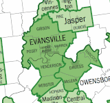
Vanderburgh County is a county in the U.S. state of Indiana. As of 2020, the population was 180,136. The county seat is in Evansville. While Vanderburgh County was the eighth-largest county in 2020 population in Indiana, it is also the eighth-smallest county in area and the smallest in southwestern Indiana, covering only 236 square miles (610 km2).

<span class="mw-page-title-main">Moores Hill, Indiana</span> Town in Indiana, United States

Moores Hill is a town in Sparta Township, Dearborn County, Indiana, United States. The population was 597 at the 2010 census.

<span class="mw-page-title-main">Somerville, Indiana</span> Town in Indiana, United States

Somerville is a town in Barton Township, Gibson County, Indiana, United States. The population was 293 at the 2010 census, making it the third-smallest community in the county.

<span class="mw-page-title-main">Switz City, Indiana</span> Town in Indiana, United States

Switz City is a town in Fairplay and Grant townships, Greene County, Indiana, United States. The population was 293 at the 2010 census. It is part of the Bloomington, Indiana, Metropolitan Statistical Area.

<span class="mw-page-title-main">Cannelton, Indiana</span> City in Indiana, United States

Cannelton is a city in Troy Township, Perry County, in the U.S. state of Indiana, along the Ohio River. The population was 1,563 at the 2010 census. Cannelton, which was the smallest incorporated city in the state until 2010, was formerly the county seat of Perry County until the seat was relocated to Tell City.

<span class="mw-page-title-main">Troy, Indiana</span> Town in Indiana, United States

Troy is a town in Troy Township, Perry County, Indiana, along the Ohio River near the mouth of the Anderson River. It is the second oldest city in Indiana. The population was 347 at the 2020 census.

<span class="mw-page-title-main">Mount Vernon, Indiana</span> City in Indiana, United States

Mount Vernon is a city in and the county seat of Posey County, Indiana, United States. Located in the state's far southwestern corner, within 15 miles (24 km) of both the southernmost or westernmost points, it is the westernmost city in the state. The southernmost is Rockport, located along the Ohio River about 40 miles (64 km) to the southeast.

<span class="mw-page-title-main">Scottsburg, Indiana</span> City in Indiana, United States

Scottsburg is a city within Vienna Township and the county seat of Scott County, in the U.S. state of Indiana, about 30 miles (48 km) north of Louisville, Kentucky. The population of Scottsburg was 7,345 at the 2020 census.

<span class="mw-page-title-main">Grandview, Indiana</span> Town in Indiana, United States

Grandview is a town in Hammond Township, Spencer County, Indiana, along the Ohio River. The population was 749 at the 2010 census.

<span class="mw-page-title-main">Rockport, Indiana</span> City in Indiana, United States

Rockport is a city in Ohio Township and the county seat of Spencer County, Indiana, along the Ohio River. The population was 2,270 at the 2010 census. Once the largest community in Spencer County, the city has recently been surpassed by the town of Santa Claus. At 37°53'1" north, Rockport is also the southernmost city in the state, located slightly south of Evansville, Cannelton, or Mount Vernon.

<span class="mw-page-title-main">Darmstadt, Indiana</span> Town in Indiana, United States

Darmstadt is a small, German-heritage town primarily located in Scott Township, Vanderburgh County, Indiana, United States. It also extends slightly into Armstrong, Center and German townships. The population was 1,407 at the 2010 census. Darmstadt, located just north of Evansville, is the only other incorporated municipality in Vanderburgh County besides Evansville.

<span class="mw-page-title-main">Fairview Park, Indiana</span> Town in Indiana, United States

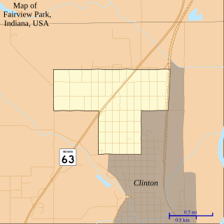
Fairview Park is a town in Clinton Township, Vermillion County, in the U.S. state of Indiana. The population was 1,386 at the 2010 census.

<span class="mw-page-title-main">Chandler, Indiana</span> Town in Indiana, United States

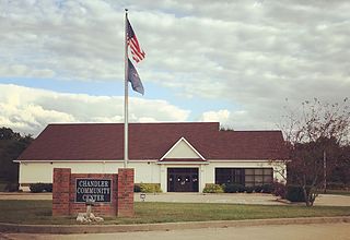
Chandler is a town straddling Ohio and Boon Township in Warrick County, Indiana, United States, located just east of Evansville, Indiana along the Ohio River. The population was 3,693 at the 2020 census, making it Warrick County's second-most populous municipality after Boonville. The town is part of the Evansville metropolitan area with a population of 342,815.

<span class="mw-page-title-main">Elberfeld, Indiana</span> Town in Indiana, United States

Elberfeld is a town in Greer Township, Warrick County, in the U.S. state of Indiana. The population was 625 as of the 2010 census.

<span class="mw-page-title-main">Lynnville, Indiana</span> Town in Indiana, United States

Lynnville is a town in Hart Township, Warrick County, in the U.S. state of Indiana. The population was 888 at the 2010 census.

<span class="mw-page-title-main">Newburgh, Indiana</span> Human settlement in USA, founded 1829

Newburgh is a borough in Ohio Township, Warrick County, Indiana, United States, along the Ohio River. The population was 3,325 at the 2010 census, although the town is part of the larger Evansville metropolitan area which recorded a population of 342,815, and Ohio Township, which Newburgh shares with nearby Chandler, has a population of 37,749 in the 2010 census with over 17,000 of those living in the town and areas adjacent to the town. It is the easternmost suburb of Evansville.

<span class="mw-page-title-main">Tennyson, Indiana</span> Town in Indiana, United States

Tennyson is a town in Skelton Township, Warrick County, in the U.S. state of Indiana. The population was 279 at the 2010 census.

<span class="mw-page-title-main">Boonville, Missouri</span> City in Missouri, United States

Boonville is a city and the county seat of Cooper County, Missouri, United States. The population was 7,964 at the 2020 census. The city was the site of a skirmish early in the Civil War, on July 17, 1861. Union forces defeated the Missouri State Guard in the first Battle of Boonville. It is part of the Columbia, Missouri metropolitan area.

<span class="mw-page-title-main">Boonville, New York</span> Town in New York, United States

Boonville is a town in Oneida County, New York, United States. The town is in the northeastern section of the county. The population was 4,555 at the 2010 census. The town includes a village, also called Boonville. The town and village are named after Gerrit Boon, an agent of the Holland Land Company. The current mayor is Judith Dellerba.

References

  1. "Mayor Charlie Wyatt". City of Boonville, IN. Retrieved February 3, 2018.
  2. "2020 U.S. Gazetteer Files". United States Census Bureau. Retrieved March 16, 2022.
  3. 1 2 U.S. Geological Survey Geographic Names Information System: Boonville, Indiana
  4. "Find a County". National Association of Counties. Archived from the original on May 31, 2011. Retrieved 2011-06-07.
  5. Fortune, William (1881). Warrick and Its Prominent People: A History of Warrick County, Indiana from the Time of Its Organization and Settlement. Courier Company. p.  21.
  6. "Warrick County". Jim Forte Postal History. Retrieved October 3, 2015.
  7. History of Warrick, Spencer, and Perry Counties, Indiana: From the Earliest Time to the Present. Goodspeed. 1885. p.  77.
  8. Carlisle, John C., “A Simple and Vital Design: The Story of the Indiana Post Office Murals”, Indiana Historical Society, Indianapolis, 1995 pp 20-21
  9. "National Register Information System". National Register of Historic Places . National Park Service. July 9, 2010.
  10. "US Gazetteer files: 2010, 2000, and 1990". United States Census Bureau. February 12, 2011. Retrieved April 23, 2011.
  11. "G001 - Geographic Identifiers - 2010 Census Summary File 1". United States Census Bureau. Archived from the original on February 13, 2020. Retrieved July 28, 2015.
  12. Climate Summary for Boonville, Indiana
  13. "NOWData – NOAA Online Weather Data". National Oceanic and Atmospheric Administration. Retrieved November 18, 2023.
  14. "Summary of Monthly Normals 1991–2020". National Oceanic and Atmospheric Administration. Retrieved November 18, 2023.
  15. "Census of Population and Housing". Census.gov. Retrieved June 4, 2015.
  16. "U.S. Census website". United States Census Bureau . Retrieved December 11, 2012.
  17. "U.S. Census website". United States Census Bureau . Retrieved 2008-01-31.
  18. "Boonville City Council". City of Boonville, IN. Retrieved February 3, 2018.
  19. FAA Airport Form 5010 for I91 – Boonville Airport PDF . Federal Aviation Administration. Effective June 30, 2011.
  20. "Indiana public library directory" (PDF). Indiana State Library. Archived from the original (PDF) on February 18, 2017. Retrieved March 15, 2018.