Switzerland County | |
---|---|
Coordinates: 38°49′N85°02′W / 38.82°N 85.03°W | |
Country | United States |
State | Indiana |
Founded | 1814 |
Named for | Switzerland |
Seat | Vevay |
Largest town | Vevay |
Area | |
• Total | 223.44 sq mi (578.7 km2) |
• Land | 220.63 sq mi (571.4 km2) |
• Water | 2.81 sq mi (7.3 km2) 1.26% |
Population (2020) | |
• Total | 9,737 |
• Estimate (2023) | 10,019 |
• Density | 44/sq mi (17/km2) |
Time zone | UTC−5 (Eastern) |
• Summer (DST) | UTC−4 (EDT) |
Congressional district | 6th |
Website | www |
Indiana county number 78 |
Switzerland County is a county in the southeast corner of the U.S. state of Indiana. As of the 2020 United States Census, the population was 9,737. [1] The county seat is Vevay, [2] one of two incorporated towns in the county.
In 1787, the fledgling United States defined the Northwest Territory, which included the area of present-day Indiana. In 1800, Congress separated Ohio from the Northwest Territory, designating the rest of the land as the Indiana Territory. [3] President Thomas Jefferson chose William Henry Harrison as the territory's first governor, and Vincennes was established as the territorial capital. [4] After the Michigan Territory was separated and the Illinois Territory was formed, Indiana was reduced to its current size and geography. [3] By December 1816 the Indiana Territory was admitted to the Union as a state.
Starting in 1794, Native American titles to Indiana lands were extinguished by usurpation, purchase, or war and treaty. The United States acquired land from the Native Americans in the 1809 treaty of Fort Wayne, and by the treaty of St. Mary's in 1818, the SE portion of Indiana Territory was acquired for settlement.
The area included in present-day Switzerland County was first placed in Knox County, formed in 1790. Parts of that extremely large county were partitioned off in 1803 to form Dearborn County and in 1810 to form Jefferson County. Settlers had been pouring into the extreme SE part of the Indiana Territory starting in 1795, and by 1814 there was sufficient population to form a local governing body. Accordingly, the state legislature authorized Switzerland County effective October 1, 1814, partitioning portions of Dearborn and Jefferson counties to make the creation. Four fledgling settlements were considered as the seat of government (Vevay, Little York [present-day Florence], Troy [present-day Patriot], and Center Square). [5] Center Square was nearest the geographic center and was the presumed site, but Vevay carried the day.
Several early settlers were originally from Switzerland. The first was probably Heathcoat Pickett, in 1795. He was followed by John James Dufour (1796), and the Dickason, Cotton, and Rayl families in 1798. Pickett also made the area's first flatboats; he floated them (loaded with goods for sale) to New Orleans and sold the entire package, then walked back to Switzerland County. He made 20 such trips. [5] Early county residents noted the passage of the first steamboat on the Ohio River in 1811; this form of transport quickly transformed the river into a conduit for commerce and travel. [5] Although Indiana was criss-crossed with railroad tracks during the nineteenth century, none was laid to Switzerland County. This hindered its growth after the decline of steamboat travel. [6] [7]
Industrial wine grape production in Switzerland County earned the area the title "The Rhineland of America". [8]
Switzerland County lies at the SE tip of Indiana, with its southeastern border defined by the Ohio River; the state of Kentucky abuts on the opposite shore. Its rolling hills were originally completely wooded. Its more flat areas have been cleared for agricultural or urban use, but its many drainages are still wooded. [9] Its highest elevation (981 feet/299 meters ASL) is a hill in its NW quadrant, 0.7 miles (1.1 km) west of Avonburg. [10]
According to the 2010 census, the county has a total area of 223.44 square miles (578.7 km2), of which 220.63 square miles (571.4 km2) (or 98.74%) is land and 2.81 square miles (7.3 km2) (or 1.26%) is water. [11]
Vevay, Indiana | ||||||||||||||||||||||||||||||||||||||||||||||||||||||||||||
---|---|---|---|---|---|---|---|---|---|---|---|---|---|---|---|---|---|---|---|---|---|---|---|---|---|---|---|---|---|---|---|---|---|---|---|---|---|---|---|---|---|---|---|---|---|---|---|---|---|---|---|---|---|---|---|---|---|---|---|---|
Climate chart (explanation) | ||||||||||||||||||||||||||||||||||||||||||||||||||||||||||||
| ||||||||||||||||||||||||||||||||||||||||||||||||||||||||||||
|
In recent years, average temperatures in Vevay have ranged from a low of 23 °F (−5 °C) in January to a high of 88 °F (31 °C) in July, although a record low of −24 °F (−31 °C) was recorded in January 1977 and a record high of 106 °F (41 °C) was recorded in July 1999. Average monthly precipitation ranged from 3.00 inches (76 mm) in February to 4.72 inches (120 mm) in May. [12]
The county government is a constitutional body, and is granted specific powers by the Constitution of Indiana, and by the Indiana Code.
County Council: The legislative branch of the county government; controls spending and revenue collection in the county. Representatives are elected to four-year terms from county districts. They set salaries, the annual budget, and special spending. The council has limited authority to impose local taxes, in the form of an income and property tax that is subject to state level approval, excise taxes, and service taxes. [13] [14]
Board of Commissioners: The executive body of the county; commissioners are elected county-wide to staggered four-year terms. One commissioner serves as president. The commissioners execute acts legislated by the council, collect revenue, and manage the county government. [13] [14]
Court: The county maintains a circuit court which was established January 1, 2009. The first Judge of the Switzerland Circuit Court is W. Gregory Coy. The Judge is elected to a term of six years. The Court is a general jurisdiction court, meaning it handles all types of cases. The Judge must be a licensed attorney. All decisions of the Court are appealable to the Indiana Court of Appeals or the Indiana Supreme Court.
County Officials: The county has other elected offices, including sheriff, coroner, auditor, treasurer, recorder, surveyor, and circuit court clerk. They are elected to four-year terms. Members elected to county government positions are required to declare party affiliations and to be residents of the county. [14]
Switzerland County is part of Indiana's 6th congressional district. [15]
Year | Republican | Democratic | Third party | |||
---|---|---|---|---|---|---|
No. | % | No. | % | No. | % | |
2020 | 3,133 | 75.33% | 964 | 23.18% | 62 | 1.49% |
2016 | 2,558 | 68.97% | 930 | 25.07% | 221 | 5.96% |
2012 | 1,872 | 55.11% | 1,437 | 42.30% | 88 | 2.59% |
2008 | 1,940 | 53.30% | 1,638 | 45.00% | 62 | 1.70% |
2004 | 2,161 | 58.87% | 1,479 | 40.29% | 31 | 0.84% |
2000 | 1,831 | 56.53% | 1,336 | 41.25% | 72 | 2.22% |
1996 | 1,266 | 39.72% | 1,496 | 46.94% | 425 | 13.34% |
1992 | 1,211 | 35.74% | 1,535 | 45.31% | 642 | 18.95% |
1988 | 1,572 | 51.39% | 1,479 | 48.35% | 8 | 0.26% |
1984 | 1,857 | 55.48% | 1,484 | 44.34% | 6 | 0.18% |
1980 | 1,584 | 47.14% | 1,704 | 50.71% | 72 | 2.14% |
1976 | 1,329 | 38.07% | 2,150 | 61.59% | 12 | 0.34% |
1972 | 1,872 | 53.53% | 1,612 | 46.10% | 13 | 0.37% |
1968 | 1,515 | 44.07% | 1,466 | 42.64% | 457 | 13.29% |
1964 | 1,390 | 38.19% | 2,231 | 61.29% | 19 | 0.52% |
1960 | 1,929 | 49.40% | 1,955 | 50.06% | 21 | 0.54% |
1956 | 2,074 | 49.28% | 2,114 | 50.23% | 21 | 0.50% |
1952 | 2,070 | 48.42% | 2,167 | 50.69% | 38 | 0.89% |
1948 | 1,839 | 43.30% | 2,375 | 55.92% | 33 | 0.78% |
1944 | 2,019 | 47.32% | 2,191 | 51.35% | 57 | 1.34% |
1940 | 2,285 | 46.01% | 2,659 | 53.54% | 22 | 0.44% |
1936 | 2,212 | 43.66% | 2,840 | 56.06% | 14 | 0.28% |
1932 | 1,953 | 38.79% | 2,981 | 59.21% | 101 | 2.01% |
1928 | 2,617 | 58.62% | 1,805 | 40.43% | 42 | 0.94% |
1924 | 2,346 | 48.29% | 2,414 | 49.69% | 98 | 2.02% |
1920 | 2,525 | 50.12% | 2,412 | 47.88% | 101 | 2.00% |
1916 | 1,214 | 44.05% | 1,446 | 52.47% | 96 | 3.48% |
1912 | 882 | 32.81% | 1,342 | 49.93% | 464 | 17.26% |
1908 | 1,444 | 47.27% | 1,537 | 50.31% | 74 | 2.42% |
1904 | 1,461 | 47.48% | 1,554 | 50.50% | 62 | 2.01% |
1900 | 1,631 | 48.50% | 1,713 | 50.94% | 19 | 0.56% |
1896 | 1,637 | 48.27% | 1,742 | 51.37% | 12 | 0.35% |
1892 | 1,497 | 47.42% | 1,589 | 50.33% | 71 | 2.25% |
1888 | 1,560 | 47.87% | 1,637 | 50.23% | 62 | 1.90% |
Census | Pop. | Note | %± |
---|---|---|---|
1820 | 3,934 | — | |
1830 | 7,028 | 78.6% | |
1840 | 9,920 | 41.1% | |
1850 | 12,932 | 30.4% | |
1860 | 12,698 | −1.8% | |
1870 | 12,134 | −4.4% | |
1880 | 13,336 | 9.9% | |
1890 | 12,514 | −6.2% | |
1900 | 11,840 | −5.4% | |
1910 | 9,914 | −16.3% | |
1920 | 9,311 | −6.1% | |
1930 | 8,432 | −9.4% | |
1940 | 8,167 | −3.1% | |
1950 | 7,599 | −7.0% | |
1960 | 7,092 | −6.7% | |
1970 | 6,306 | −11.1% | |
1980 | 7,153 | 13.4% | |
1990 | 7,738 | 8.2% | |
2000 | 9,065 | 17.1% | |
2010 | 10,613 | 17.1% | |
2020 | 9,737 | −8.3% | |
2023 (est.) | 10,019 | [17] | 2.9% |
US Decennial Census [18] 1790-1960 [19] 1900-1990 [20] 1990-2000 [21] 2010-2013 [1] |
As of the 2010 United States Census, there were 10,613 people, 4,034 households, and 2,847 families in the county. [22] The population density was 48.1 inhabitants per square mile (18.6/km2). There were 4,969 housing units at an average density of 22.5 per square mile (8.7/km2). [11] The racial makeup of the county was 97.8% white, 0.3% black or African American, 0.2% Asian, 0.2% American Indian, 0.7% from other races, and 0.8% from two or more races. Those of Hispanic or Latino origin made up 1.4% of the population. [22] In terms of ancestry, 25.4% were German, 16.1% were American, 13.2% were Irish, and 10.1% were English. [23]
Of the 4,034 households, 33.5% had children under the age of 18 living with them, 54.2% were married couples living together, 10.0% had a female householder with no husband present, 29.4% were non-families, and 24.3% of all households were made up of individuals. The average household size was 2.60 and the average family size was 3.07. The median age was 39.1 years. [22]
The median income for a household in the county was $47,697 and the median income for a family was $51,769. Males had a median income of $39,167 versus $30,814 for females. The per capita income for the county was $21,214. About 11.0% of families and 14.4% of the population were below the poverty line, including 19.2% of those under age 18 and 7.5% of those age 65 or over. [24]
Darke County is a county in the U.S. state of Ohio. As of the 2020 census, the population was 51,881. Its county seat and largest city is Greenville. The county was created in 1809 and later organized in 1817. It is named for William Darke, an officer in the American Revolutionary War. Darke County comprises the Greenville, OH Micropolitan Statistical Area, which is also included in the Dayton-Springfield-Sidney, OH Combined Statistical Area.
Wells County is a county in the U.S. state of Indiana. As of the 2020 United States Census, the population was 28,180. The county seat is Bluffton.
Shelby County is a county in the U.S. state of Indiana. As of the 2020 United States Census, the population was 45,055. The county seat is Shelbyville.
Rush County is a county in the U.S. state of Indiana. In the 2020 United States Census, the population was 16,752. The county seat is Rushville.
Ripley County is a county located at the southeastern corner of the U.S. state of Indiana. According to the 2020 Census, the population was 28,995. The county seat is Versailles.
Posey County is the southernmost, southwesternmost, and westernmost county in the U.S. state of Indiana. Its southern border is formed by the Ohio River, and its western border by the Wabash River, a tributary to the Ohio. As of 2020, the population was 25,222. The county seat is Mount Vernon.
Owen County is a county in the U.S. state of Indiana. In 1920 the United States Census Bureau calculated the mean center of U.S. population to fall within this county. As of the 2020 United States Census, it had a population of 21,321. Its county seat is Spencer.
Miami County is a county located in the U.S. state of Indiana. As of 2020, the population was 35,962. The county seat is the City of Peru. Miami County is part of the Kokomo-Peru CSA.
Madison County is a county in the U.S. state of Indiana. The 2020 census states the population is standing at 130,129. The county seat since 1836 has been Anderson, one of three incorporated cities within the county.
Jennings County is a county located in the U.S. state of Indiana. As of 2020, the population was 27,613. The county seat is Vernon.
Jefferson County is a county located in the U.S. state of Indiana. As of 2020, the population was 33,147. The county seat is Madison.
Greene County is a county in the U.S. state of Indiana. As of 2020, the population was 30,803. The county seat is Bloomfield. The county was determined by the US Census Bureau to include the mean center of U.S. population in 1930.
Decatur County is a county in the U.S. state of Indiana. As of the 2020 United States Census, the population was 26,472. The county seat is Greensburg.
Carroll County is a county located in the U.S. state of Indiana. As of the 2020 United States Census, the population was 20,306. The county seat is Delphi.
Jefferson County is a county located in the U.S. state of Idaho. As of the 2020 Census, the county's population was 30,891. The county seat and largest city is Rigby. The county was established in 1913 and named after Thomas Jefferson, the third U.S. President. Jefferson County is part of the Idaho Falls, ID Metropolitan Statistical Area.
Mount Etna is a town in Huntington County, Indiana, United States. The population was 94 at the 2010 census. It lies at the intersection of four townships: Jefferson, Lancaster, Polk and Wayne.
Vevay is a town located in Jefferson Township and the county seat of Switzerland County, Indiana, United States, along the Ohio River. The population was 1,683 at the 2010 census.
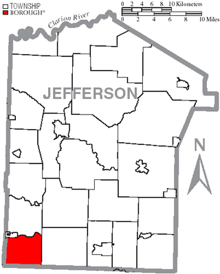
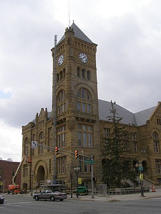
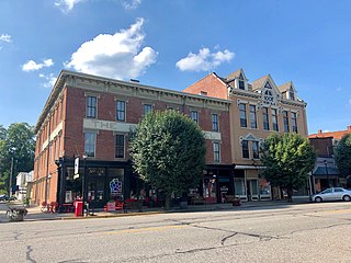
Porter Township is a township in Jefferson County, Pennsylvania, United States. The population was 294 at the 2020 census.
St. Clair County is a county located in the central portion of the U.S. state of Alabama. As of the 2020 census, the population was 91,103. It has two county seats: Ashville and Pell City. It is one of two counties in Alabama, and one of 33 in the United States, with more than one county seat. Its name is in honor of General Arthur St. Clair, an officer in the French and Indian War. St. Clair County is included in the Birmingham, Alabama Metropolitan Statistical Area.
Scott County is a county located in the U.S. state of Indiana. As of 2020, the population was 24,384. The county seat is Scottsburg.