It has a population density of about 39 inhabitants per square mile (15/km2).[3] The county contains six incorporated towns and many unincorporated communities. It is divided into 13 townships which provide local services.[4][5]
Two U.S. Routes and five state highways pass through or into the county, along with one major railroad line.[6][7]
Parke County is included in the Terre Haute, Indiana, Metropolitan Statistical Area.
History
This area had been occupied for thousands of years by cultures of indigenous peoples. The first European settlement of the western area of Indiana along the Wabash River was by French-Canadian colonists, who founded Vincennes in 1703.
After the Seven Years' War, France ceded its territory in North America to Great Britain. In turn, after the American Revolutionary War, the Crown ceded this territory east of the Mississippi River to the new United States, including land it did not control, which was occupied by Native American nations.
In 1811 the Shawnee chief Tecumseh rallied several tribes to try to expel the European-American settlers from the area. When General William Henry Harrison took an army from Vincennes to the Battle of Tippecanoe in late 1811 to fight with the Indians, Zachariah Cicott served as a scout. Cicott had traded with Indians up and down the Wabash River, starting around 1801. The trail taken by Harrison's army, on its way to and from the battle site in Tippecanoe County, passed through the area that later became Parke County. The settlement of Armiesburg in Wabash Township was so named because Harrison and his army crossed the Raccoon Creek and camped near there on their way to the battle.[10]
First located at Roseville, the county seat was relocated to Armiesburg. In 1822, the county settled on Rockville as the permanent location. The state act had called for construction of county buildings to start within one year of the county's formation; but in the event, it did not start until 1824. The first courthouse was completed on the Rockville town square in 1826. The log structure doubled as a church.[12]
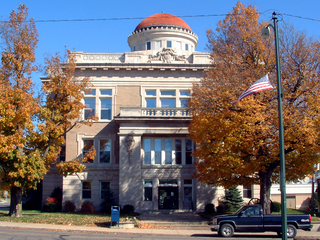
The old Parke County courthouse (1832-1879)
In 1832 the log building was replaced by a brick structure, which served for more than 40 years until 1879, when it was demolished for replacement by a new stone courthouse. The architects for this building were Thomas J. Tolan and his son Brentwood of Fort Wayne; they designed seven Indiana courthouses, as well as two in Ohio, and one each in Iowa and Illinois. (The firm also designed the Rockville sheriff's resident and jail, as well as others in Indiana, Ohio, Michigan, Illinois, Iowa and Tennessee).
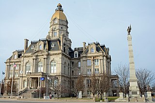
Construction of the courthouse at Rockville was completed in 1882 at a cost of about $79,000.[n 1][14] Items deposited in the cornerstone included documents of the town's history, postage stamps, several varieties of grain grown in the county, coins, and photographs. A dedication ceremony took place on February 22, 1882, the anniversary of George Washington's birthday. The clock and bell were added later at a cost of about $1,500.[15]
The Wabash and Erie Canal was completed through the area around 1850 and ran through Parke County on the east side of the Wabash River. It served several communities along the banks of the river until it was discontinued in the 1870s.[16]
Geography
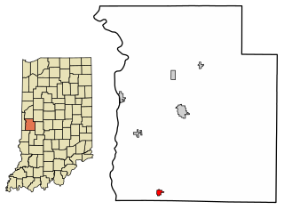
Map of Parke County, showing townships and settlements
Parke County lies in western Indiana about halfway between the state's north and south borders. It is bordered by Fountain County to the north; Montgomery County to the northeast; Putnam County to the east; Clay County to the south; and Vigo County to the southwest. The county's western border is defined by the Wabash River; on the west side of the river lies Vermillion County, beyond which is the state of Illinois, less than 5 miles (8.0km) from Parke County's northwestern corner. The state capital of Indianapolis lies about 60 miles (97km) to the east.[17]
The entire county is within the drainage area of the Wabash River. North of Rockville, the gently undulating land is glacial till resulting from Wisconsinan glaciation. The Shelbyville moraine divides this from the nearly level Illinoisan till plain in the south part of the county.[18]
Turkey Run State Park is located in northern Parke County. It was set aside as one of Indiana's first state parks and consists of 2,382 acres (964ha) of land.[19] The county also contains a portion of Shades State Park, a 3,082-acre (1,247ha) park about 5 miles (8.0km) northeast of Turkey Run; the majority of Shades is located in Montgomery County.[20]
According to the 2010 census, the county has a total area of 449.98 square miles (1,165.4km2), of which 444.66 square miles (1,151.7km2) (or 98.82%) is land and 5.32 square miles (13.8km2) (or 1.18%) is water.[3]
Cities and towns
Parke County contains six incorporated settlements. The largest is Rockville with a population of about 2,600; located near the center of the county at the intersections of U.S. Routes 36 and 41, it is also the county seat. Bloomingdale is about 5 miles (8.0km) to the north-northwest of Rockville and has a population of 335. To the north-northeast of Rockville lies Marshall, on Indiana State Road 236; its population is 324. To the southwest of Rockville, Mecca has a population of 335. Montezuma is at the far western edge of the county on U.S. Route 36; its population is 1,022. Finally, Rosedale is near the southern border of the county and has a population of 725.
Two United States highways pass through the county. U.S. Route 36 passes east–west through the middle of the county, entering from Putnam County to the east, through Rockville and Montezuma, then into Vermillion County to the west.[21]U.S. Route 41 enters from Fountain County to the north and intersects U.S. Route 36 in Rockville; it goes southwest toward Clinton before continuing south to Vigo County and Terre Haute, Indiana.[22]
Indiana State Road 47 begins at U.S. Route 41 in the northern part of the county and goes east into Montgomery County, veering north to Crawfordsville.[23]Indiana State Road 59 enters from Clay County to the south and runs north through the eastern part of the county until it terminates at Indiana State Road 236, which runs east from U.S. Route 41.[24][25]Indiana State Road 163 runs for less than a mile in Parke County, crossing the river at Clinton and terminating at U.S. Route 41 in the far southwest corner of the county.[26] In the far northwestern corner, Indiana State Road 234 enters from Cayuga and runs for less than a mile to Lodi before going north and leaving the county.[27]
A small portion of a major CSX Transportation railroad line passes through the southwest corner of the county, entering from Clinton to the west, then going south toward Terre Haute. Another CSX line enters the far southeastern corner of the county on its way from Terre Haute to Indianapolis.[7]
Economy
Historically a rural county with extensive agriculture, today Parke County's economy is supported by a labor force of approximately 8,050 workers. The unemployment rate in November2011 was 9.6%.[28]
In recent years, average temperatures in Rockville have ranged from a low of 19°F (−7°C) in January to a high of 87°F (31°C) in July, although a record low of −25°F (−32°C) was recorded in January 1994 and a record high of 109°F (43°C) was recorded in July 1936. Average monthly precipitation ranged from 2.25 inches (57mm) in February to 4.89 inches (124mm) in July.[29] From 1950 through 2009, eight tornadoes were reported in Parke County; none resulted in any deaths or injuries, but the total estimated property damage was over $280,000.[30]
Notable people
Warder Clyde Allee was born in Bloomingdale in 1885. He attended Earlham College and the University of Chicago, studying zoology and ecology and receiving his Ph.D. in 1912. He taught, conducted research, and wrote a number of books; among other accomplishments, he identified what became known as the Allee effect. He died in Gainesville, Florida, in 1955 at age 69.[31]
Gordon Allport
Gordon Allport was born in Montezuma in 1897; when he was six years old, his family moved to Ohio. He attended Harvard University and received a Ph.D. in psychology in 1922; his focus was on personality traits. He began teaching at Harvard in 1924, and published a number of works in the following years. He died in Cambridge, Massachusetts in 1967 at the age of 69.[32]
William Henry Harrison Beadle was born in a log cabin in Parke County in 1838. His father offered him a farm, but he accepted $1,000 for an education instead and studied civil engineering at the University of Michigan. He fought in the Civil War on the side of the Union and became a brigadier general. After the war, he was named surveyor-general of the Dakota Territory. Later he became president of the Madison State Normal School (now Dakota State University), then taught geography there after his presidency. He died in 1915 at the age of 77.[33]
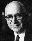
Mordecai Brown in 1904
Baseball great Mordecai Brown was born in the unincorporated town of Nyesville in Parke County on October 19, 1876. He lost parts of two fingers on his right hand in a farm machinery accident, hence his later nickname "Three Finger". He was also called "Miner" because he had worked in coal mines in western Indiana before his baseball career. He began in the minor leagues in Terre Haute in 1901 and joined the major leagues in 1903, retiring in 1916. He died in Terre Haute in 1948 at age 71.[34]
Grover Jones was born in Rosedale in 1893 and grew up in the Terre Haute area. He became a short story writer, screenwriter, and film director, writing for over 100 films. He died in Hollywood, California, in 1940 at age 46.[35]
The county's first newspaper was called The Wabash Herald and was published beginning in 1829. After being sold and renamed several times, it was successively called The Rockville Intelligencer, The Olive Branch, The Parke County Whig and The Rockville Republican. Several other papers came and went; as of 1912, several newspapers were published in the county: the Republican, the Tribune, the Montezuma Enterprise, and the Bloomingdale World, as well as papers printed in Rosedale and Marshall.[36] The original Wabash Herald continues and since 1977 has been called the Parke County Sentinel.[37]
The county government is a constitutional body granted specific powers by the Constitution of Indiana and the Indiana Code. The county council is the legislative branch of the county government and controls all spending and revenue collection. Representatives are elected from county districts. The council members serve four-year terms and are responsible for setting salaries, the annual budget and special spending. The council also has limited authority to impose local taxes, in the form of an income and property tax that is subject to state level approval, excise taxes and service taxes.[38][39] In 2010, the county budgeted approximately $2.2million for the district's schools and $2.8million for other county operations and services, for a total annual budget of approximately $5million.[40]
The executive body of the county is made of a board of commissioners. The commissioners are elected county-wide, in staggered terms, and each serves a four-year term. One of the commissioners, typically the most senior, serves as president. The commissioners are charged with executing the acts legislated by the council, collecting revenue and managing day-to-day functions of the county government.[38][39]
The county maintains a small claims court that can handle some civil cases. The judge on the court is elected to a term of four years and must be a member of the Indiana Bar Association. The judge is assisted by a constable who is elected to a four-year term. In some cases, court decisions can be appealed to the state level circuit court.[39]
The county has several other elected offices, including sheriff, coroner, auditor, treasurer, recorder, surveyor and circuit court clerk. Each of these elected officers serves a term of four years and oversees a different part of county government. Members elected to county government positions are required to declare party affiliations and be residents of the county.[39]
Each of the townships has a trustee who administers rural fire protection and ambulance service, provides poor relief and manages cemetery care, among other duties.[5] The trustee is assisted in these duties by a three-member township board. The trustees and board members are elected to four-year terms.[41]
Parke County is a consistently Republican county in presidential elections, having voted for Democratic Party candidates only four times since 1888, and not at all since Lyndon B. Johnson's national landslide in 1964.
United States presidential election results for Parke County, Indiana[44]
As of the 2010 United States Census, there were 17,339people, 6,222households, and 4,389families residing in the county.[51] The population density was 39.0 inhabitants per square mile (15.1/km2). There were 8,085 housing units at an average density of 18.2 per square mile (7.0/km2).[52] The racial makeup of the county was 96.1% white, 2.3% black or African American, 0.4% American Indian, 0.2% Asian, 0.4% from other races, and 0.6% from two or more races. Those of Hispanic or Latino origin made up 1.2% of the population.[51] In terms of ancestry, 27.7% were American, 23.7% were German, 10.7% were Irish, and 10.1% were English.[53]
Of the 6,222households, 29.8% had children under the age of 18 living with them, 56.4% were married couples living together, 9.4% had a female householder with no husband present, 29.5% were non-families, and 24.8% of all households were made up of individuals. The average household size was 2.51 and the average family size was 2.97. The median age was 41.3 years.[51]
The median income for a household in the county was $47,697 and the median income for a family was $51,581. Males had a median income of $40,395 versus $27,618 for females. The per capita income for the county was $19,494. About 8.8% of families and 15.8% of the population were below the poverty line, including 26.9% of those under age 18 and 9.3% of those age 65 or over.[54]
↑ A $79,000 capital expense in 1880 would be roughly equivalent to $18,000,000 in 2010.[13]
Related Research Articles
Warren County is a county in the U.S. state of Indiana. It lies in the western part of the state between the Illinois state line and the Wabash River. According to the 2020 census, it had a population of 8,440. Its county seat is Williamsport.
Vigo County is a county on the western border of the U.S. state of Indiana. According to the 2020 United States Census, it had a population of 106,153. Its county seat is Terre Haute.
Vermillion County lies in the western part of the U.S. state of Indiana between the Illinois border and the Wabash River. As of the 2020 census, the population was 15,439. The county seat is Newport. It was officially established in 1824 and was the fiftieth Indiana county created. Vermillion County is included in the Terre Haute, Indiana, Metropolitan Statistical Area. The county contains seven incorporated towns with a total population of about 9,900. as well as several unincorporated communities; it is also divided into five townships which provide local services. An interstate highway, two U.S. routes, and five state roads cross the county, as does a major railroad line.
Sullivan County is a county in the U.S. state of Indiana, and determined by the US Census Bureau to include the mean center of U.S. population in 1940. As of 2020, the population was 20,758. The county seat is Sullivan.
Fountain County lies in the western part of the U.S. state of Indiana on the east side of the Wabash River. The county was officially established in 1826 and was the 53rd in Indiana. The county seat is Covington.
Terre Haute is a city in and the county seat of Vigo County, Indiana, United States, about 5 miles (8 km) east of the state's western border with Illinois. As of the 2020 census, the city had a population of 58,389 and its metropolitan area had a population of 168,716.
Bloomingdale is a town in Penn Township, Parke County, in the U.S. state of Indiana. The population was 335 at the 2010 census.
Mecca is a town in Wabash Township, Parke County, in the U.S. state of Indiana. The population was 335 at the 2010 census.
Montezuma is a town in Reserve Township, Parke County, in the U.S. state of Indiana. The population was 1,022 at the 2010 census. It is located approximately 66 miles west of the state capital Indianapolis.
Rockville is a town in Adams Township, Parke County, in the U.S. state of Indiana. The population was 2,607 at the 2010 census. The town is the county seat of Parke County. It is known as "The Covered Bridge Capital of the World".
Rosedale is a town in Florida Township, Parke County, in the U.S. state of Indiana. The population was 725 at the 2010 census.
Clinton is a city in Clinton Township, Vermillion County, in the U.S. state of Indiana. The population was 4,893 at the 2010 census.
Dana is a town in Helt Township, Vermillion County, Indiana, United States. The population was 555 at the 2020 census. It is primarily a farming community.
West Terre Haute is a town in Sugar Creek Township, Vigo County, Indiana, on the western side of the Wabash River near Terre Haute. The population was 2,236 at the 2010 census. It is part of the Terre Haute Metropolitan Statistical Area. Bethany Congregational Church was placed on the National Register of Historic Places in 2003.
Adams Township is one of thirteen townships in Parke County, Indiana, United States. As of the 2020 census, its population was 5,100 and it contained 1,985 housing units.
Harrison Township is one of twelve townships in Vigo County, Indiana, United States. As of the 2010 census, its population was 51,272 and it contained 22,940 housing units. It is entirely contained in Terre Haute's city limits, thus explaining why it is both the most densely populated and the most populated overall.
Honey Creek Township is one of twelve townships in Vigo County, Indiana, United States. As of the 2010 census, its population was 17,179 and it contained 6,509 housing units. It contains Terre Haute's main shopping district along U.S. Route 41 and is by far the most characteristically suburban of the twelve Vigo County townships. The population includes inmates from the Terre Haute Federal Penitentiary, located at its northwest corner.
Prairieton Township is one of twelve townships in Vigo County, Indiana, United States. As of the 2010 census, its population was 1,222 and it contained 517 housing units.
Wabash Township is one of thirteen townships in Parke County, Indiana, United States. As of the 2020 census, its population was 768 and it contained 325 housing units.
Armiesburg is an unincorporated community in Wabash Township, Parke County, in Indiana.
↑ Williamson, Samuel H. (April 2010). Seven Ways to Compute the Relative Value of a U.S. Dollar Amount, 1774 to present. MeasuringWorth. Calculations made using Nominal GDP Per Capita, a measure of capital intensivity, using "the 'average' per-person output of the economy in the prices of the current year." This is a measure of the amount of capital and volume of labor required to reproduce the work over varying production methods, but assuming that money represents a proportion of the economy.
This page is based on this Wikipedia article Text is available under the CC BY-SA 4.0 license; additional terms may apply. Images, videos and audio are available under their respective licenses.