U.S. Route 166 (US 166) is a 164-mile (264 km) west–east United States highway. This route and US-266 are the only two remaining spurs of historic U.S. Route 66, since US-666 was renumbered to US-491 in 2003.
U.S. Route 302 is an east–west spur of U.S. Route 2 in northern New England in the United States. It currently runs 171 miles (275 km) from Montpelier, Vermont, beginning at US 2, to Portland, Maine, at U.S. Route 1. It passes through the states of Vermont, New Hampshire and Maine.
U.S. Route 224 (US 224) is a spur of US 24 that runs through the states of Indiana, Ohio and Pennsylvania. It currently runs for 289 miles (465 km) from Huntington, Indiana. at US 24 to New Castle, Pennsylvania, at US 422 Business and Pennsylvania Route 18 (PA 18). It goes through the cities of Canfield, Ohio, Akron, Ohio, and Findlay, Ohio. In Northeast Ohio, US 224 is located a short distance north of the Western Reserve's southern boundary.
U.S. Route 163 is a 64-mile (103 km) U.S. Highway that runs from US 160 northward to US 191 in the U.S. states of Arizona and Utah. The southernmost 44 miles (71 km) of its length are within the Navajo Nation. The highway forms part of the Trail of the Ancients, a National Scenic Byway. The highway cuts through the heart of Monument Valley and has been featured in numerous movies and commercials.
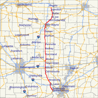
State Road 1 is a north–south state highway in the eastern portion of the U.S. state of Indiana. Its southern terminus is at U.S. Highway 50 in east-central Dearborn County, just east of Lawrenceburg. Its northern terminus is at U.S. Highway 20 in east-central Steuben County, approximately six miles east of Angola.
State Road 38 in the U.S. State of Indiana serves as a connection between Lafayette in the west and Richmond in the east.

State Road 61 is a 64-mile (103 km) north–south route that runs through portions of three counties in the southwest part of the U.S. State of Indiana.
State Road 75, the highest two-digit route in the U.S. state of Indiana consists of two discontinuous north–south segments.
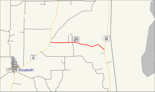
State Road 211 is a short east–west connector route in southeast Harrison County in the U.S. State of Indiana.

State Road 234 exists in two sections in Indiana. The western portion begins at the Illinois border from a Vermilion County, Illinois, county road. It runs east from there to U.S. Route 136 (US 136) near Jamestown. Much of the route is a scenic, two-lane road with very tight turns. The primary access to Shades State Park is located along SR 234.

Louisiana Highway 16 (LA 16) is a state highway located in southeastern Louisiana. It runs 110.27 miles (177.46 km) in a general east–west direction from LA 22 south of French Settlement to LA 21 in Sun.

State Road 520 is a four-lane connector about 1,000 feet in length. It exists solely to connect U.S. Route 12 and U.S. Route 20 in Pines, about 3 miles (5 km) west of Michigan City. U.S. 12 and U.S. 20 do not cross at this point — they parallel each other for another 22 miles (35 km) westbound and overlap in Gary; U.S. 20 is generally considered the faster of the two, while U.S. 12 is the scenic Dunes Highway. Eastbound, U.S. 12 travels through Michigan City and northeast into Michigan where it forks east from the Red Arrow Highway. U.S. 20 stays in Indiana and runs around Michigan City as a bypass to the south.
Interstate 64 (I-64) in the U.S. state of Illinois is a major east–west Interstate highway that runs from the St. Louis metropolitan area east to the Indiana state line near Grayville, Illinois. It travels a distance of 130.4 miles (209.9 km).

State Road 263 is a business route of State Road 63 which runs through West Lebanon in Warren County, covering a distance of about 13 miles (21 km). It is an undivided two-lane surface road for its entire length.
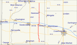
State Road 341 in the U.S. state of Indiana is a north–south state highway in Fountain County in the west-central part of the state.

State Road 357 in the U.S. state of Indiana is a very short north–south state highway in Gibson County, entirely within the city of Oakland City.

State Road 116 is a State Road in the northern section of the US state of Indiana. Running for about 32 miles (51 km) in a general southeast-northwest direction and it is signed east-west. The road connects Markle, Bluffton, and Geneva and passes through mostly farmland outside of cities and towns. SR 116 was originally introduced in the early 1930s routed between Markle and SR 3 north of Bluffton. The road was extended southeast to U.S. Highway 27 in the late 1930s and early 1940s. In the mid-1940s the road was extended east to the Ohio state line, near New Corydon. This extension was removed between late 1990s and early 2000s, the east end of SR 116 was truncated to its current location at US 27.

State Road 301 in the U.S. state of Indiana is a short north–south route in Wells County in the northeastern part of the state.

U.S. Route 6 is a part of the United States Numbered Highway System that runs from Bishop, California to Provincetown, Massachusetts. US 6 is the second longest federal highway in the United States, second only to U.S. Route 20. In Ohio, the road runs west-east from the Indiana state line near Edgerton to the Pennsylvania state line near Andover. The 248.002 miles (399.121 km) that lie in Ohio are maintained by the Ohio Department of Transportation (ODOT). US 6 serves the major cities of Sandusky, Lorain, and Cleveland. The highway is also called the Grand Army of the Republic Highway to honor the Union forces of the American Civil War. The alternate name was designated in 1953.


