Cayuga, Indiana

Last updated

Cayuga, Indiana
Cayuga-Patterson-Curtis-in.jpg
Businesses along Patterson Street
Vermillion County Indiana Incorporated and Unincorporated areas Cayuga Highlighted 1810954.svg
Location of Cayuga in Vermillion County, Indiana.
Map of Cayuga, Indiana.svg
Map of Cayuga
Coordinates: 39°56′50″N87°27′53″W / 39.94722°N 87.46472°W / 39.94722; -87.46472
Country United States
State Indiana
County Vermillion
Township Eugene
Established1827
Area
[1]
  Total1.01 sq mi (2.62 km2)
  Land1.01 sq mi (2.62 km2)
  Water0.00 sq mi (0.00 km2)
Elevation
[2]
505 ft (154 m)
Population
 (2020)
  Total952
  Density939.78/sq mi (362.69/km2)
Time zone UTC-5 (EST)
  Summer (DST) UTC-5 (EST)
ZIP code
47928
Area code 765
FIPS code 18-10954 [3]
GNIS feature ID 432255

Cayuga is a town in Eugene Township, Vermillion County, in the U.S. state of Indiana. [4] The population was 1,162 at the 2010 census.

Contents

History

When the town was laid out on September 20, 1827, it was called Eugene Station, [5] though it was also called Osonimon after an Indian chief of that name. [6] It was later renamed after the village of Cayuga and Cayuga Lake in the state of New York; an early settler named John Groenendyke had originally come from Cayuga County, New York, and moved to Vigo County in 1818, then in 1819 moved to the area that later became Vermillion County. The name is based on the Iroquois term Gwa-u-geh, meaning "the place of taking out" (in terms of a portage). Local legend attributes the name to the sound made by the horn of a Ford Model T. [7] The town was incorporated around 1891. [8]

The Cayuga post office has been in operation since 1886. [9]

Geography

Cayuga is located at the intersection of Indiana State Road 63 and Indiana State Road 234, in the northern half of the county, near the confluence of the Vermillion and Wabash rivers.

According to the 2010 census, Cayuga has a total area of 1.01 square miles (2.62 km2), all land. [10]

Demographics

Historical population
CensusPop.Note
1900 832
1910 9119.5%
1920 9332.4%
1930 9683.8%
1940 1,12616.3%
1950 1,022−9.2%
1960 904−11.5%
1970 1,09020.6%
1980 1,25815.4%
1990 1,083−13.9%
2000 1,1092.4%
2010 1,1624.8%
2020 952−18.1%
U.S. Decennial Census [11]

2010 census

As of the census [12] of 2010, there were 1,162 people, 475 households, and 329 families living in the town. The population density was 1,150.5 inhabitants per square mile (444.2/km2). There were 523 housing units at an average density of 517.8 per square mile (199.9/km2). The racial makeup of the town was 97.8% White, 0.2% African American, 0.5% Native American, 0.1% Asian, 0.3% from other races, and 1.2% from two or more races. Hispanic or Latino of any race were 0.5% of the population.

There were 475 households, of which 29.9% had children under the age of 18 living with them, 50.5% were married couples living together, 13.7% had a female householder with no husband present, 5.1% had a male householder with no wife present, and 30.7% were non-families. 26.7% of all households were made up of individuals, and 14.9% had someone living alone who was 65 years of age or older. The average household size was 2.45 and the average family size was 2.89.

The median age in the town was 43.2 years. 22.5% of residents were under the age of 18; 8.4% were between the ages of 18 and 24; 21.4% were from 25 to 44; 30.1% were from 45 to 64; and 17.6% were 65 years of age or older. The gender makeup of the town was 48.2% male and 51.8% female.

2000 census

As of the census [3] of 2000, there were 1,109 people, 466 households, and 313 families living in the town. The population density was 1,106.8 inhabitants per square mile (427.3/km2). There were 517 housing units at an average density of 516.0 per square mile (199.2/km2). The racial makeup of the town was 98.38% White, 0.09% African American, 0.99% Native American, and 0.54% from two or more races. Hispanic or Latino of any race were 0.90% of the population.

There were 466 households, out of which 29.6% had children under the age of 18 living with them, 53.9% were married couples living together, 8.8% had a female householder with no husband present, and 32.8% were non-families. 30.3% of all households were made up of individuals, and 19.1% had someone living alone who was 65 years of age or older. The average household size was 2.38 and the average family size was 2.93.

In the town, the population was spread out, with 24.1% under the age of 18, 9.5% from 18 to 24, 25.5% from 25 to 44, 24.4% from 45 to 64, and 16.5% who were 65 years of age or older. The median age was 38 years. For every 100 females, there were 91.2 males. For every 100 females age 18 and over, there were 88.8 males.

The median income for a household in the town was $31,053, and the median income for a family was $40,536. Males had a median income of $30,179 versus $19,583 for females. The per capita income for the town was $16,042. About 8.5% of families and 9.9% of the population were below the poverty line, including 14.1% of those under age 18 and 11.2% of those age 65 or over

Industry

Related Research Articles

<span class="mw-page-title-main">Michigantown, Indiana</span> Town in Indiana, United States

Michigantown is a town in Michigan Township, Clinton County, Indiana, United States. The population was 467 at the 2010 census. The town was named for the Michigan Road, an early thoroughfare through the area.

<span class="mw-page-title-main">Mulberry, Indiana</span> Town in Indiana, United States

Mulberry is a town in Madison Township, Clinton County, Indiana, United States. The population was 1,231 at the 2020 census. The town was named for a mulberry tree which grew at the point where it was founded.

<span class="mw-page-title-main">Rossville, Indiana</span> Town in Indiana, United States

Rossville is a town in Ross Township, Clinton County, Indiana, United States. The population was 1,653 at the 2010 census.

<span class="mw-page-title-main">St. Paul, Indiana</span> Town in Indiana, United States

St. Paul or Saint Paul is a small town on the border of Decatur and Shelby counties in the U.S. state of Indiana. The population was 1,031 at the 2010 census.

<span class="mw-page-title-main">Ashley, Indiana</span> Town in Indiana, United States

Ashley is a town in Indiana located on the border of Smithfield Township, DeKalb County and Steuben Township, Steuben County. The population was 983 at the 2010 census.

<span class="mw-page-title-main">Fort Branch, Indiana</span> Town in Indiana, United States

Fort Branch is the largest town and 2nd largest community in Gibson County, Indiana after Princeton. The population was 2,965 at the 2020 census. It is part of the Evansville, Indiana, Metropolitan Area.

<span class="mw-page-title-main">Stilesville, Indiana</span> Town in Indiana, United States

Stilesville is a town in Franklin Township, Hendricks County, Indiana, United States. The population was 316 at the 2010 Census.

<span class="mw-page-title-main">Bloomingdale, Indiana</span> Town in Indiana, United States

Bloomingdale is a town in Penn Township, Parke County, in the U.S. state of Indiana. The population was 335 at the 2010 census.

<span class="mw-page-title-main">Mecca, Indiana</span> Town in Indiana, United States

Mecca is a town in Wabash Township, Parke County, in the U.S. state of Indiana. The population was 335 at the 2010 census.

<span class="mw-page-title-main">Montezuma, Indiana</span> Town in Indiana, United States

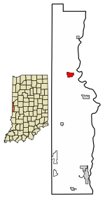
Montezuma is a town in Reserve Township, Parke County, in the U.S. state of Indiana. The population was 1,022 at the 2010 census. It is located approximately 66 miles west of the state capital Indianapolis.

<span class="mw-page-title-main">Rockville, Indiana</span> Town in Indiana, United States

Rockville is a town in Adams Township, Parke County, in the U.S. state of Indiana. The population was 2,607 at the 2010 census. The town is the county seat of Parke County. It is known as "The Covered Bridge Capital of the World".

<span class="mw-page-title-main">Rosedale, Indiana</span> Town in Indiana, United States

Rosedale is a town in Florida Township, Parke County, in the U.S. state of Indiana. The population was 725 at the 2010 census.

<span class="mw-page-title-main">Bainbridge, Indiana</span> Town in Indiana, United States

Bainbridge is a town in Monroe Township, Putnam County, in the U.S. state of Indiana. The population was 746 at the 2010 census.

<span class="mw-page-title-main">Russellville, Indiana</span> Town in Indiana, United States

Russellville is a town in Russell Township, Putnam County, in the U.S. state of Indiana. The population was 358 at the 2010 census.

<span class="mw-page-title-main">Clinton, Indiana</span> City in Indiana, United States

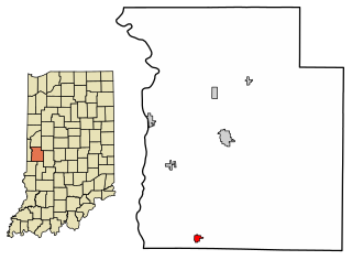
Clinton is a city in Clinton Township, Vermillion County, in the U.S. state of Indiana. The population was 4,893 at the 2010 census.

<span class="mw-page-title-main">Dana, Indiana</span> Town in Indiana, United States

Dana is a town in Helt Township, Vermillion County, Indiana, United States. The population was 555 at the 2020 census. It is primarily a farming community.

<span class="mw-page-title-main">Fairview Park, Indiana</span> Town in Indiana, United States

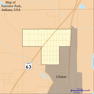
Fairview Park is a town in Clinton Township, Vermillion County, in the U.S. state of Indiana. The population was 1,386 at the 2010 census.

<span class="mw-page-title-main">Newport, Indiana</span> Town in Indiana, United States

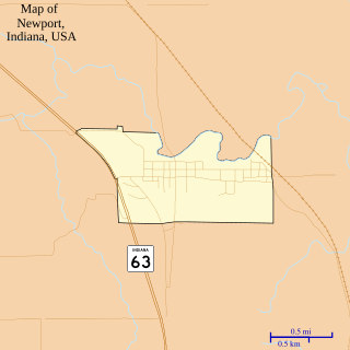
Newport is a town in Vermillion Township, Vermillion County, in the U.S. state of Indiana. The population was 515 at the 2010 census. The town is the county seat of Vermillion County.

<span class="mw-page-title-main">Perrysville, Indiana</span> Town in Indiana, United States

Perrysville is a town in Highland Township, Vermillion County, in the U.S. state of Indiana. The population was 456 at the 2010 census.

<span class="mw-page-title-main">Universal, Indiana</span> Town in Indiana, United States

Universal is a town in Clinton Township, Vermillion County, in the U.S. state of Indiana. The population was 362 at the 2010 census.

References

  1. "2020 U.S. Gazetteer Files". United States Census Bureau. Retrieved March 16, 2022.
  2. "US Board on Geographic Names". United States Geological Survey. October 25, 2007. Retrieved January 31, 2008.
  3. 1 2 "U.S. Census website". United States Census Bureau . Retrieved January 31, 2008.
  4. "Cayuga, Indiana". Geographic Names Information System . United States Geological Survey, United States Department of the Interior . Retrieved July 15, 2016.
  5. Bowen 1913, p. 362.
  6. Bowen 1913, p. 401.
  7. Baker, Ronald L.; Marvin Carmony (1975). Indiana Place Names. Indiana University Press. p. 26. ISBN   0-253-14167-2.
  8. Bowen 1913, pp. 401–402.
  9. "Vermillion County". Jim Forte Postal History. Retrieved July 15, 2016.
  10. "G001 - Geographic Identifiers - 2010 Census Summary File 1". United States Census Bureau. Archived from the original on February 13, 2020. Retrieved July 13, 2015.
  11. "Census of Population and Housing". Census.gov. Retrieved June 4, 2015.
  12. "U.S. Census website". United States Census Bureau . Retrieved December 11, 2012.

Bibliography