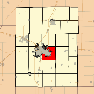
Vermilion County is a county in the eastern part of the U.S. state of Illinois, between the Indiana border and Champaign County. It was established in 1826 and was the 45th of Illinois' 102 counties. According to the 2020 United States census, it had a population of 74,188. It contains 21 incorporated settlements; the county seat and largest city is Danville.

The Illinois River is a 145-mile-long (233 km) tributary of the Arkansas River in the U.S. states of Arkansas and Oklahoma. The Osage Indians named it Ne-eng-wah-kon-dah, which translates as "Medicine Stone River". The state of Oklahoma has designated its portion as a Scenic River.
The Blackwater River is a 79.3-mile-long (127.6 km) tributary of the Lamine River in west-central Missouri in the United States. Via the Lamine and Missouri rivers, it is part of the watershed of the Mississippi River. The Blackwater River was named from the character of its banks and water.
The Mackinaw River is a 130-mile-long (210 km) tributary of the Illinois River in the U.S. state of Illinois. Its watershed covers approximately 1,136 square miles (3,000 km2), and contains some of the most productive agricultural land in the United States. The river itself maintains some of the highest quality streams in the state and provides habitat for 60-70 native fish species and 25-30 species of mussels. Its name, also spelled Mackinac, is derived from the Ojibwe word mikinaak meaning "turtle".

The Embarras River is a 195-mile-long (314 km) tributary of the Wabash River in southeastern Illinois in the United States. The waters of the Embarras reach the Gulf of Mexico via the Wabash, Ohio, and Mississippi Rivers. The river drains a watershed around 1,566,450 acres (6,339.2 km2) in an agricultural region. It arises near Champaign-Urbana and flows south to near Vincennes, Indiana. The name comes from French explorers, who used the French word, embarras, for river navigation obstacles, blockages, and difficulties relating to logjams.

The Little Wabash River is a 240-mile-long (390 km) tributary of the Wabash River in east-central and southeastern Illinois in the United States. Via the Wabash and Ohio rivers, it is part of the watershed of the Mississippi River. It is the third largest tributary after the White River and the Embarras River.

Boneyard Creek is a 3.3-mile-long (5.3 km) waterway that drains much of the cities of Champaign and Urbana, Illinois, United States. It is a tributary of the Saline Branch of the Salt Fork Vermilion River, which is a tributary of the south-flowing Vermilion River and the Wabash River. The creek flows through the northern sections of the campus of the University of Illinois Urbana-Champaign. The newsletter of the university's ACM chapter is Banks of the Boneyard, named after the creek.

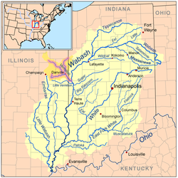
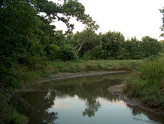
The Vermilion River is a 74.8-mile-long (120.4 km) tributary of the Illinois River in the state of Illinois, United States. The river flows north, in contrast to a second Vermilion River in Illinois, which flows south to the Wabash River. The Illinois and Wabash rivers each have a tributary named the Little Vermilion River as well.
The Middle Fork of the Vermilion River is a tributary of the Vermilion River in Illinois. The Middle Fork rises in Ford County and flows southeast to join the Vermilion near Danville.
The Salt Fork is a tributary of the Vermilion River located in the Central Corn Belt Plains of Illinois.
Bonpas Creek is a tributary of the Wabash River in Illinois. It rises to the east of Olney in Richland County, Illinois. Flowing south, it forms the boundary between Edwards and Wabash counties. The creek is 58.4 miles (94.0 km) long. It joins the Wabash near Grayville, Illinois. In the last 2 miles (3 km) of its watercourse, it occupies part of a former Wabash oxbow bend. As such, the creek now also forms part of the state boundary between White County, Illinois, and Gibson County, Indiana, as flows past Grayville in the former channel.
The Fox River is a tributary of the Little Wabash River in southern Illinois. It rises in Jasper County to the southeast of Newton and flows south past Olney, then joins the Little Wabash at the northeast corner of Edwards County, near Mt. Erie. The river is 46.4 miles (74.7 km) in length.
The West Okaw River is a tributary of the Kaskaskia River, which it joins in Moultrie County, Illinois. The West Okaw forms an arm of Lake Shelbyville where the natural rivers used to meet.
Salt Creek is a major tributary to the Sangamon River, which it joins at the boundary between Mason and Menard County, Illinois. There are at least two other Salt Creeks in Illinois, Salt Creek, and in Effingham County, Illinois.
The Little Vermilion River is a 34.7-mile-long (55.8 km) tributary of the Illinois River, which it joins near LaSalle, Illinois, opposite the north-flowing Vermilion River. There is another "Little Vermilion River" in Illinois which is a tributary of the Wabash River.
Urbana Township is a township in Champaign County, Illinois, USA. As of the 2020 census, its population was 7,556 and it contained 3,463 housing units.
This article is a timeline of Vermilion County, Illinois history.
The Saline Branch, or Saline Branch Ditch, is a tributary of the Vermilion River in east central Illinois. It drains a parcel of east-central Champaign County, including most of the city of Urbana, Illinois and the University of Illinois campus within Urbana.