Outline of Indiana

Last updated
The location of the state of Indiana in the United States of America Map of USA IN.svg
The location of the state of Indiana in the United States of America

The following outline is provided as an overview of and topical guide to the U.S. state of Indiana:

Contents

Indiana a U.S. state, was admitted to the United States as the 19th state on December 11, 1816. It is located in the midwestern United States and Great Lakes Region of North America. With 6,483,802 residents, as of the 2010 U.S. Census, the state is ranked 15th in population and 16th in population density. [1] [2] [3] Indiana is ranked 38th in land area [1] and is the smallest state in the contiguous U.S. west of the Appalachian Mountains. [4] Indiana's capital and largest city is Indianapolis, [5] the second largest of any state capital and largest state capital east of the Mississippi River.[ citation needed ]

General reference

An enlargeable map of the state of Indiana Map of Indiana NA.png
An enlargeable map of the state of Indiana

Geography of Indiana

Geography of Indiana

Places in Indiana

Environment of Indiana

Natural geographic features of Indiana

Human-made geographical features of Indiana

Regions of Indiana

An enlargeable map of the 92 counties of the state of Indiana Indiana Counties.jpg
An enlargeable map of the 92 counties of the state of Indiana

Administrative divisions of Indiana

Demography of Indiana

Demographics of Indiana

Government and politics of Indiana

Politics of Indiana

Federal government in Indiana

Elections and political parties in Indiana

Branches of the government of Indiana

Government of Indiana

Executive branch of the government of Indiana

Legislative branch of the government of Indiana

Judicial branch of the government of Indiana

Courts of Indiana

Law and order in Indiana

Law of Indiana

Military in Indiana

Local government in Indiana

History of Indiana

History of Indiana

By period

The location of the state of Indiana in the United States of America Map of USA IN.svg
The location of the state of Indiana in the United States of America
An enlargeable map of the state of Indiana Map of Indiana NA.png
An enlargeable map of the state of Indiana
An enlargeable map of the 92 counties of the state of Indiana Indiana Counties.jpg
An enlargeable map of the 92 counties of the state of Indiana

By region

By subject

More

Culture of Indiana

Culture of Indiana

The arts in Indiana

Sports in Indiana

Sports in Indiana

Economy and infrastructure of Indiana

Economy of Indiana

Education in Indiana

Education in Indiana

See also

Related Research Articles

<span class="mw-page-title-main">Northwest Territory</span> United States territory (1787–1803)

The Northwest Territory, also known as the Old Northwest and formally known as the Territory Northwest of the River Ohio, was formed from unorganized western territory of the United States after the American Revolution. Established in 1787 by the Congress of the Confederation through the Northwest Ordinance, it was the nation's first post-colonial organized incorporated territory.

<span class="mw-page-title-main">Treaty of Greenville</span> 1795 treaty ending the Northwest Indian War

The Treaty of Greenville, also known to Americans as the Treaty with the Wyandots, etc., but formally titled A treaty of peace between the United States of America, and the tribes of Indians called the Wyandots, Delawares, Shawanees, Ottawas, Chippewas, Pattawatimas, Miamis, Eel Rivers, Weas, Kickapoos, Piankeshaws, and Kaskaskias was a 1795 treaty between the United States and indigenous nations of the Northwest Territory, including the Wyandot and Delaware peoples, that redefined the boundary between indigenous peoples' lands and territory for European American community settlement.

<span class="mw-page-title-main">Michigan Territory</span> Territory of the US, 1805–1837

The Territory of Michigan was an organized incorporated territory of the United States that existed from June 30, 1805, until January 26, 1837, when the final extent of the territory was admitted to the Union as the State of Michigan. Detroit was the territorial capital.

<span class="mw-page-title-main">Indiana Territory</span> 1800–1816 territory of the United States

The Indiana Territory, officially the Territory of Indiana, was created by an organic act that President John Adams signed into law on May 7, 1800, to form an organized incorporated territory of the United States that existed from July 4, 1800, to December 11, 1816, when the remaining southeastern portion of the territory was admitted to the Union as the state of Indiana. The territory originally contained approximately 259,824 square miles (672,940 km2) of land, but its size was decreased when it was subdivided to create the Michigan Territory (1805) and the Illinois Territory (1809). The Indiana Territory was the first new territory created from lands of the Northwest Territory, which had been organized under the terms of the Northwest Ordinance of 1787. The territorial capital was the settlement around the old French fort of Vincennes on the Wabash River, until transferred to Corydon near the Ohio River in 1813.

<span class="mw-page-title-main">Index of Indiana-related articles</span>

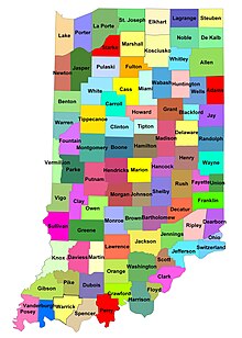
The following is an alphabetical list of articles related to the U.S. state of Indiana.

<span class="mw-page-title-main">Index of Louisiana-related articles</span>

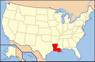
The following is an alphabetical list of articles related to the U.S. state of Louisiana.

<span class="mw-page-title-main">Index of Ohio-related articles</span>

The following is an alphabetical list of articles related to the U.S. state of Ohio.

<span class="mw-page-title-main">Indian removals in Indiana</span> Removal of native tribes from Indiana

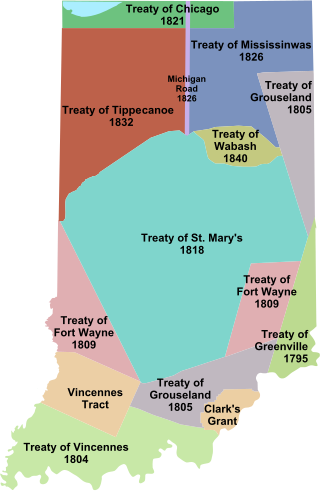
Indian removals in Indiana followed a series of the land cession treaties made between 1795 and 1846 that led to the removal of most of the native tribes from Indiana. Some of the removals occurred prior to 1830, but most took place between 1830 and 1846. The Lenape (Delaware), Piankashaw, Kickapoo, Wea, and Shawnee were removed in the 1820s and 1830s, but the Potawatomi and Miami removals in the 1830s and 1840s were more gradual and incomplete, and not all of Indiana's Native Americans voluntarily left the state. The most well-known resistance effort in Indiana was the forced removal of Chief Menominee and his Yellow River band of Potawatomi in what became known as the Potawatomi Trail of Death in 1838, in which 859 Potawatomi were removed to Kansas and at least forty died on the journey west. The Miami were the last to be removed from Indiana, but tribal leaders delayed the process until 1846. Many of the Miami were permitted to remain on land allotments guaranteed to them under the Treaty of St. Mary's (1818) and subsequent treaties.

<span class="mw-page-title-main">Indiana</span> U.S. state

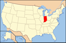
Indiana is a U.S. state in the Midwestern United States. It is the 38th-largest by area and the 17th-most populous of the 50 States. Its capital and largest city is Indianapolis. Indiana was admitted to the United States as the 19th state on December 11, 1816. It is bordered by Lake Michigan to the northwest, Michigan to the north and northeast, Ohio to the east, the Ohio River and Kentucky to the south and southeast, and the Wabash River and Illinois to the west.

<span class="mw-page-title-main">Outline of Florida</span> Overview of and topical guide to Florida

The following outline is provided as an overview of and topical guide to the U.S. state of Florida:

<span class="mw-page-title-main">Outline of Kentucky</span> Overview of and topical guide to Kentucky

The following outline is provided as an overview of and topical guide to the United States Commonwealth of Kentucky:

<span class="mw-page-title-main">Outline of Louisiana</span> Overview of and topical guide to Louisiana

The following outline is provided as an overview of and topical guide to the U.S. state of Louisiana:

<span class="mw-page-title-main">Outline of Maryland</span> Overview of and topical guide to Maryland

The following outline is provided as an overview of and topical guide to the U.S. state of Maryland:

<span class="mw-page-title-main">Outline of Michigan</span> Overview of and topical guide to Michigan

The following outline provides an overview of and topical guide to the U.S. state of Michigan:

<span class="mw-page-title-main">Outline of Minnesota</span> Overview of and topical guide to Minnesota

The following outline is provided as an overview of and topical guide to the U.S. state of Minnesota:

<span class="mw-page-title-main">Outline of Mississippi</span> Overview of and topical guide to Mississippi

The following outline is provided as an overview of and topical guide to the U.S. state of Mississippi:

<span class="mw-page-title-main">Outline of New York</span> Overview of and topical guide to New York

The following outline is provided as an overview of and topical guide to the U.S. State of New York:

<span class="mw-page-title-main">Outline of Ohio</span> Overview of and topical guide to Ohio

The following outline is provided as an overview of and topical guide to the U.S. state of Ohio:

<span class="mw-page-title-main">Outline of Wisconsin</span> Overview of and topical guide to Wisconsin

The following outline is provided as an overview of, and a topical guide to, the U.S. state of Wisconsin:

References

  1. 1 2 "States ranked by population density". Worldatlas.com. 21 June 2023.
  2. "Guide to State and Local Census GeographyIndiana, 2010 U.S. Census". U.S. Census Bureau. Retrieved 2012-08-09.
  3. "State & County QuickFacts Indiana". U.S. Census Bureau. Archived from the original on 2012-04-23. Retrieved 2012-08-09.
  4. "The Geography of Indiana". Netstate. Retrieved 2012-08-13.
  5. "Guide to State and Local Census Geography Indiana". U.S. Census Bureau. 2011-12-22. Retrieved 2012-08-13.
  6. The official sobriquet of the State of Indiana has given rise to the humorous constructions Hoosierana (the land of Hoosiers; see uses in Indiana Journalism Hall of Fame Archived 2005-09-12 at the Wayback Machine and by sports journalist Frank DeFord) and Hoosierstan (the place of Hoosiers).
  7. "U.S. Census Bureau State & County QuickFacts Indiana". Archived from the original on 2012-04-23.
  8. "Profile of the People and Land of the United States". National Atlas of the United States. Archived from the original on 2012-09-15. Retrieved 2012-08-17.

Gnome-globe.svg Wikimedia Atlas of Indiana