
Topography is the study of the forms and features of land surfaces. The topography of an area may refer to the land forms and features themselves, or a description or depiction in maps.

The Geographic Names Information System (GNIS) is a database of name and location information about more than two million physical and cultural features throughout the United States and its territories; the associated states of the Marshall Islands, Federated States of Micronesia, and Palau; and Antarctica. It is a type of gazetteer. It was developed by the United States Geological Survey (USGS) in cooperation with the United States Board on Geographic Names (BGN) to promote the standardization of feature names.

The Sun River is a tributary of the Missouri River in the Great Plains, approximately 130 mi (209 km) long, in Montana in the United States.

The DuPage River is a 28.3-mile-long (45.5 km) tributary of the Des Plaines River in the U.S. state of Illinois.

The elevation of a geographic location is its height above or below a fixed reference point, most commonly a reference geoid, a mathematical model of the Earth's sea level as an equipotential gravitational surface . The term elevation is mainly used when referring to points on the Earth's surface, while altitude or geopotential height is used for points above the surface, such as an aircraft in flight or a spacecraft in orbit, and depth is used for points below the surface.

The North Canadian River is a river, 440 miles (710 km) long, in Oklahoma in the United States. It is a tributary of the Canadian River, draining an area of 17,955 square miles (46,500 km2) in a watershed that includes parts of northeastern New Mexico and the Texas Panhandle.
Henry Gannett was an American geographer who is described as the "father of mapmaking in America." He was the chief geographer for the United States Geological Survey essentially from its founding until 1902.

The Raccoon River is a 30.8-mile-long (49.6 km) tributary of the Des Moines River in central Iowa in the United States. As measured using the longest of its three forks, its length increases to 226 miles (364 km). Via the Des Moines River, it is part of the watershed of the Mississippi River. The river runs through an intensely cultivated area of croplands and livestock farming, receiving Tile drainage from slow-draining rich natural bottomland.
Courtois Creek is a 38.6-mile-long (62.1 km) stream in southern Missouri, United States. It shares its name with the nearby town of Courtois and is in the Courtois Hills region of the Missouri Ozarks. According to the information in the Ramsay Place Names File at the University of Missouri, the creek was "doubtless named for some French settler, but his identity has not been ascertained".

California is a unique place that has not always been well understood. For hundreds of years there persisted a European misconception that California was an island and many maps were made depicting it as such. Eventually, by the 18th century, enough information about California reached the outside world to dispel that myth. As California became increasingly populated, comprehensive surveying and mapping of its territory seemingly expanded slowly. When gold was discovered in 1848 and it joined the United States as the thirty first state in 1851 and interest in plotting California's landscapes boomed.

A national mapping agency (NMA) is an organisation, usually publicly owned, that produces topographic maps and geographic information of a country. Some national mapping agencies also deal with cadastral matters.
Geologic mapping of Georgia is the creation of geologic maps—special-purpose maps made to show geological features—of the State of Georgia in the United States. Rock units or geologic strata are shown by colors or symbols to indicate where they are exposed at the surface. Structural features such as faults and shear zones are also shown. Since the first national geological map, in 1809, there have been numerous maps which included the geology of Georgia. The first Georgia-specific geologic map was created in 1825. The most recent state-produced geologic map of Georgia, by the Georgia Department of Natural Resources is 1:500,000 scale, and was created in 1976 by the department's Georgia Geological Survey. It was generated from a base map produced by the United States Geological Survey. The state geologist and Director of the Geological Survey of Georgia was Sam M. Pickering, Jr. Since 1976, several geological maps of Georgia, featuring the state's five distinct geologic regions, have been produced by the federal government.
The East Branch Mattawamkeag River is a tributary of the Mattawamkeag River in Aroostook County, Maine. From its source in Dudley, the river runs 36 miles (58 km) south and southeast to its confluence with the West Branch Mattawamkeag River in Haynesville, about 10 miles (16 km) west of the Canada–United States border.
The Seboeis River is a river in Penobscot County, Maine. The river is the outflow of Snowshoe Lake in Maine Township 7, Range 7, WELS; Snowshoe Lake is fed via a short stream from Grand Lake Seboeis. The river runs 28.1 miles (45.2 km) south — through White Horse Lake, Seboeis Deadwater, Upper Seboeis River Gorge, and Gagnon Flat — to its confluence with the East Branch of the Penobscot River in T.3 R.7 WELS.

The United States Geological Survey (USGS), founded as the Geological Survey, is an agency of the United States government whose work spans the disciplines of biology, geography, geology, and hydrology. The agency was founded on March 3, 1879, to study the landscape of the United States, its natural resources, and the natural hazards that threaten it. The agency also makes maps of extraterrestrial planets and moons based on data from U.S. space probes.
Slocums River is a 4.3-mile-long (6.9 km) tidal river in southeastern Massachusetts in the United States. The Paskamanset River and Slocums River really form just a single river, but the freshwater portion kept its earlier Indian name, while the salt-water portion is named for the early settlers of the area, the Slocum family.
Philip Burke King was a geologist who worked for the United States Geological Survey. He was born in Chester, Indiana. King graduated from Iowa State University and Yale University. He spent most of his career from 1930 onward as a geologist with the U.S. Geological Survey. He taught at universities for short periods:, Arizona (1929–30), UCLA (1954–56), and in the autumn of 1965 was a visiting lecturer at the University of Moscow.
The National Hydrography Dataset (NHD) is a digital database of surface water features used to make maps. It contains features such as lakes, ponds, streams, rivers, canals, dams and stream gages for the United States.

François Émile Matthes was a geologist and an expert in topographic mapping, glaciers, and climate change. He mapped remote areas of the American West for the United States Geological Survey (USGS). His maps coincided with the development of those areas into national parks. He is one of the founders of the Association of American Geographers and served as its president. Matthes resolved a dispute about formation of the Yosemite Valley and his findings on glaciers introduced the terms nivation and Little Ice Age.
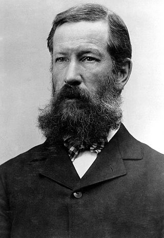
Edward Morehouse Douglas was one of the first topographers employed by the U.S. Geological Survey. When Douglas began work in 1882, the goal of the new government agency was to produce an integrated topographic map of the United States to support development of natural resources including land, water, and forests. This was the plan of its director, appointed the previous year, John Wesley Powell (1834-1902). Douglas remained at the USGS for the next forty-eight years. A civil engineer who earned a degree at Columbia School of Mines in 1881, he eventually supervised all crews in the Rocky Mountain region extending from Montana to Arizona. In 1911 he became director of the Topographic Branch’s Computing Division. In 1923 he authored the standard work on boundary surveys that remained in use through the 1960s.

