Northern Indiana

Last updated
Northern Indiana
Northern Indiana.png
Map of counties in Indiana. Those highlighted in red are part of Northern Indiana.
CountryUnited States
State Indiana
Largest city Fort Wayne
Population
 (2020)
2,317,804

Northern Indiana is a geographic and cultural region that generally comprises the northern third of the U.S. state of Indiana and borders the states of Illinois to the west, Michigan to the north, and Ohio to the east. Spanning the state's northernmost 26 counties, its main population centers include Northwest Indiana (anchored by the cities of Hammond and Gary and part of the larger Chicago metropolitan area), Michiana (anchored by the cities of South Bend, Mishawaka, and Elkhart), and the Fort Wayne metropolitan area (anchored by the city of Fort Wayne).

Contents

Northern Indiana's physical geography was significantly shaped during Wisconsin glaciation, resulting in a till plain ranging from flat to gently rolling terrain, especially in the Wabash Valley. The region experiences a humid continental climate, supporting temperate deciduous forest, prairie, and wetland ecosystems. In addition to Lake Michigan, more than 300 kettle lakes are located in the region, including the state's largest natural lake (Wawasee) and deepest natural lake (Tippecanoe). Following the Valparaiso Moraine, the Laurentian Divide meanders through the region, separating the watersheds of the Great Lakes Basin to the north from those of the Mississippi River drainage basin to the south.

Northern Indiana is situated within the larger Rust Belt and Corn Belt regions, influencing the area's geographic, economic, cultural, and political landscape. Home to about 2.3 million people, the region is defined by both its industrial cities and agricultural towns. Manufacturing remains a vital part of the region's economy, particularly in the production of recreational vehicles, medical devices, and steel. Protected areas include Indiana Dunes National Park and Indiana's most visited state park of the same name. [1] Northern Indiana is home to about 25 public and private higher education institutions, including more than a dozen religiously affiliated colleges and universities. The region is split between the Eastern and Central time zones. [2]

Geography

Major waterways include the Grand Calumet River, the Kankakee River, the Maumee River (St. Marys and St. Joseph rivers), the St. Joseph River (Elkhart River), and the Wabash River (Eel, Little, and Tippecanoe rivers). Besides Lake Michigan, other notable lakes and reservoirs include Lake Freeman, Lake George, Lake James, Lake Manitou, Lake Maxinkuckee, Lake Shafer, Lake Tippecanoe, Lake Wawasee, Webster Lake, and Wolf Lake.

Sub-regions

Michiana

Michiana, a portmanteau of "Michigan" and "Indiana", is a loosely defined sub-region that spans southwestern Michigan and Northern Indiana's north-central counties. It is centered on the South Bend–Elkhart–Mishawaka Combined Statistical Area and generally corresponds with Area code 574. Counties typically considered part of the Michiana sub-region include:

Northeast Indiana

Northeast Indiana comprises the northeastern portion of Northern Indiana, centered on the Fort Wayne–Huntington–Auburn Combined Statistical Area and generally corresponding with Area code 260. Counties typically considered part of the Northeast Indiana sub-region include:

Northwest Indiana

Northwest Indiana, colloqially known as "The Region", [3] comprises the northwestern portion of Northern Indiana, centered on the southeastern extent of the Chicago metropolitan area and generally corresponding with Area code 219. Counties typically considered part of the Northwest Indiana sub-region include:

Other counties

Benton and White counties have economic ties to the Lafayette–West Lafayette metropolitan area, typically considered part of Central Indiana. Cass and Miami counties have economic ties to the Kokomo metropolitan area, also typically considered part of Central Indiana. Portions of these counties fall within Area code 765.

Time zones

Most of Northern Indiana (20 counties) observes Eastern Time. Six counties in the Northwest Indiana sub-region (Jasper, Lake, LaPorte, Newton, Porter, and Starke counties) observe Central Time.

Largest municipalities

Fort Wayne is the largest city in Northern Indiana and second-largest in the state. Downtown Fort Wayne, Indiana Skyline from Old Fort, May 2014.jpg
Fort Wayne is the largest city in Northern Indiana and second-largest in the state.
South Bend is the second-largest city in Northern Indiana and fourth-largest in the state. South-bend-indiana-courthouse.jpg
South Bend is the second-largest city in Northern Indiana and fourth-largest in the state.

The major cities of Northern Indiana are Fort Wayne (in the northeast), South Bend (in the north-central region), and Hammond and Gary (in the extreme northwest along Lake Michigan).

2020 rankCityCounty2020 Census2010 CensusChangeHighest Population (Year)
1 Fort Wayne Allen 263,852253,691+4.01% [4] 263,852 (2020)
2 South Bend St. Joseph 103,675101,168+2.48% [5] 132,445 (1960)
3 Hammond Lake 77,75480,830−3.81% [6] 111,698 (1960)
4 Gary Lake 68,98280,294−14.09% [7] 178,320 (1960)
5 Elkhart Elkhart 54,04450,949+6.07% [8] 54,044 (2020)
6 Mishawaka St. Joseph 51,20148,252+6.11% [9] 51,201 (2020)
7 Portage Porter 37,93436,828+3.00% [10] 37,934 (2020)
8 Merrillville Lake 36,60335,246+3.85% [11] 36,603 (2020)
9 Goshen Elkhart 34,84931,719+9.87% [12] 34,849 (2020)
10 Valparaiso Porter 34,15431,730+7.64% [13] 34,154 (2020)

Demographics

Historical population
CensusPop.Note
1890 524,581
1900 597,43313.9%
1910 687,86715.1%
1920 809,77017.7%
1930 1,015,94225.5%
1940 1,085,2516.8%
1950 1,297,93919.6%
1960 1,621,35724.9%
1970 1,802,56211.2%
1980 1,891,7414.9%
1990 1,901,2090.5%
2000 2,062,9338.5%
2010 2,147,7654.1%
2020 2,317,8047.9%
U.S. Decennial Census [14]

Northern Indiana has experienced steady population growth over the past century (except at the 1990 U.S. census). Between 1980 and 1990, Lake County (which includes the city of Gary) saw a population decline of 47,371 residents, and it was this drop in population that hid the population rise which continued to occur in the majority of the region's other counties. The 2015 Census Estimate [15] has shown that the rural counties (i.e., Wabash and Wells) are seeing a gradual population decline when compared to the gradual increase (or steady) population trend in the more urban counties (i.e., St. Joseph). The trend of rural counties losing population has been observed in various counties in other regions, most notably the Great Plains.

Roughly 10.7% of both Huntington and Wells County live in poverty, as compared to only 15.5% in Pulaski County. At the same time, Northern Indiana, as is the case for much of the Midwest, is predominately made up of people of European heritage. According to the 2010 Census, almost 98% of Whitley County is white, as compared to Lake County (Gary), which is only 64.4% white and 25.9% African American. Lastly, the average family size per household is relatively constant around 3.00 persons per household. In 2010, the average family size per household was 3.66 in LaGrange County, 3.23 in Elkhart County, 3.19 in Lake County, 3.16 in Noble County, 3.15 in Marshall County, and 3.12 in Allen County. [16]

Northern Indiana is known for having the third-highest Amish population in the U.S., especially in Allen, Adams, Elkhart, and LaGrange counties. [17]

Dialect

The Inland North dialect of American English is mostly found in the Calumet region of Northern Indiana. The Northern cities vowel shift is recognizable in Northwest Indiana and the Michiana area. However, the rest of Northern Indiana tends to exhibit North Midland dialect, with little recognizable influences. [18] Because of the city's transitional location between the Inland North, North Midland, and Central Midland dialects, Fort Wayne has been difficult for linguists to define, with some labeling speech here "virtually accent neutral," attributed to historical settlement patterns. [19]

Economy

U.S. STEEL PLANT - NARA - 547097 (retouched).jpg
U.S. Steel Gary Works in 1973
Amish farm in Elkhart County, Indiana.jpg
Farm near Middlebury in 2016

Northern Indiana bases much of its economy around manufacturing, distribution and transportation, and medical devices. Outside the metropolitan areas, the region's agricultural sector is abundant provided its location within the fertile Corn Belt. Northern Indiana is also situated in the heart of the Rust Belt, an area of the U.S. that has suffered deindustrialization and some economic stagnation since the late 20th century.

The Calumet region of Northwest Indiana is home to much heavy industry, notably steel mills. The Calumet region is the nation's second-largest steel-producing area. [20] U.S. Steel's Gary Works (in Gary) was once the largest steel mill in the world and employed 30,000. [21] :90 Gary Works remains North America's largest integrated steel mill. [22] Northwest Indiana is also a vital trade and shipping center for the state. The Port of Indiana–Burns Harbor handles more ocean-going cargo than any other Great Lakes port in the U.S. [23]

The north central area of Northern Indiana, centered on Warsaw, is home to several companies specializing in the development and production of orthopedic medical devices. Nearly one-third of the $38 billion global orthopedic industry is concentrated in north central Indiana. [24] Elkhart and surrounding municipalities in the Michiana region are home to the largest concentration of recreational vehicle and mobile home manufacturers in the U.S., including Forest River, Gulf Stream Coach, Heartland Recreational Vehicles, Jayco, and Monaco Coach, among several others. Some 83 percent of American RVs are produced in Elkhart County. [25] The automotive industry is another significant driver of the region's economy. General Motors' Fort Wayne Assembly near Roanoke produces the Chevrolet Silverado and GMC Sierra. South Bend-based AM General manufactures the civilian Hummer H1 and military Humvee at its Mishawaka assembly plant.

Gambling is an important sector of the region's economy. Northern Indiana is home to three riverboat casinos (Ameristar in East Chicago, Blue Chip in Michigan City, and Horseshoe in Hammond), one land-based casino (Hard Rock in Gary), and one tribal casino (Four Winds in South Bend), owned by the Pokagon Band of Potawatomi Indians.

Energy

Natural gas is primarily supplied by the Northern Indiana Public Service Company (NIPSCO), a subsidiary of Merrillville-based NiSource. Electric utilities serving the region include NIPSCO, Indiana Michigan Power (a subsidiary of American Electric Power), and Duke Energy Indiana (a subsidiary of Duke Energy). Four of Indiana's five hydroelectric power plants are located in Northern Indiana. Two are owned by Indiana Michigan Power (the Elkhart and Twin Branch dams on the St. Joseph River) and two are owned by NIPSCO (the Norway and Oakdale dams on the Tippecanoe River). The company also operates two coal-fired power stations in the region: Michigan City Generating Station and R. M. Schahfer in Wheatfield.

Northern Indiana's share of renewable energy generation, particularly solar and wind sources, has increased since the late 2000s. Wind farms are common in rural Benton and White counties, including Fowler Ridge, the largest wind farm in the American Midwest. Upon its completion, the Mammoth Solar project will be the largest in the U.S., covering 13,000 acres across rural Starke and Pulaski counties. [26]

BP's Whiting Refinery in Whiting is the largest inland oil refinery in the U.S., processing 435,000 barrels (69,200 m3) of crude oil daily. [27]

Two regional transmission organizations serving the nation's electrical grid provide coverage to portions of Northern Indiana: Midcontinent Independent System Operator and PJM Interconnection. [28]

Companies

Do it Best corporate headquarters in Fort Wayne. In 2022, Do it Best was the largest privately held company in the state of Indiana, with US$5.5 billion in revenue. Electric Works, Do it Best, Broadway District, SE corner, Fort Wayne, IN 2024-04-12.jpg
Do it Best corporate headquarters in Fort Wayne. In 2022, Do it Best was the largest privately held company in the state of Indiana, with US$5.5 billion in revenue.

Notable companies headquartered in Northern Indiana include:

Protected areas

National

Indiana Dunes National Park is the most visited protected area in the region, receiving some 2.8 million visitors annually. IndianaDunesBathHouse.jpg
Indiana Dunes National Park is the most visited protected area in the region, receiving some 2.8 million visitors annually.

State

Educational institutions

Main Building on the campus of the University of Notre Dame, a private Catholic research university in St. Joseph County known for its Fighting Irish athletic program. Winter Dome.jpg
Main Building on the campus of the University of Notre Dame, a private Catholic research university in St. Joseph County known for its Fighting Irish athletic program.

About 25 accredited institutions of higher education are located throughout Northern Indiana, including more than a dozen private, liberal arts colleges and Christian seminaries, and multiple regional campuses of the public Indiana, Purdue, and Ivy Tech Community College systems. The "‡" symbol indicates universities with main campuses outside Northern Indiana.

Public

Private

Transportation

Two of Indiana's six state-designated scenic byways—the Historic Michigan Road Byway and the Lincoln Highway Scenic Byway—traverse portions of Northern Indiana.

Roads

Interstate Highways

US Highways

State Roads

Mass transit

NICTD South Shore Line commuter train in Michigan City 07 21 09 006xRP - Flickr - drewj1946.jpg
NICTD South Shore Line commuter train in Michigan City

Airports

Most of Northern Indiana's 26 public aviation facilities are categorized as general aviation airports; however, the region is also home to two primary airports and one relief airport. In addition, two United States Air Force installations are based in the region.

Primary

Relief

General aviation

Military

Maritime

Notable people

See also

Related Research Articles

<span class="mw-page-title-main">Berrien County, Michigan</span> County in Michigan, United States

Berrien County is a county in the U.S. state of Michigan. It is located at the southwest corner of the state's Lower Peninsula, located on the shore of Lake Michigan and sharing a land border with Indiana. As of the 2020 Census, the population was 154,316. The county seat is St. Joseph.

<span class="mw-page-title-main">LaPorte County, Indiana</span> County in Indiana, United States

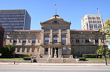
LaPorte County is a county located in the U.S. state of Indiana. As of 2020, the population was 112,417. The county seat is the city of La Porte, and the largest city is Michigan City. This county is part of the Northwest Indiana and Michiana regions of the Chicago metropolitan area. The LaPorte County Courthouse is located in the county seat of La Porte and is listed on the National Register of Historic Places.

<span class="mw-page-title-main">Elkhart County, Indiana</span> County in Indiana, United States

Elkhart County is a county located in the U.S. state of Indiana. As of 2020, the county's population was 207,047. The county seat is Goshen. Elkhart County is part of the Elkhart-Goshen Metropolitan Statistical Area, which in turn is part of the South Bend-Elkhart-Mishawaka Combined Statistical Area. It is also considered part of the broader region of Northern Indiana known as Michiana, and is 20 miles (32 km) east of South Bend, Indiana, 110 miles (180 km) east of Chicago, Illinois, and 150 miles (240 km) north of Indianapolis, Indiana. The area is referred to by locals as the recreation vehicle (RV) capital of the world and is known for its sizable Amish and Old Order Mennonite population.

<span class="mw-page-title-main">Watersheds of Indiana</span>

The Watersheds of Indiana consist of six distinct Indiana watershed regions that drain into five major bodies of water.

<span class="mw-page-title-main">Michiana</span> Geographic region in Indiana and Michigan, United States

Michiana is a region in northern Indiana and southwestern Michigan centered on the city of South Bend, Indiana. The Chamber of Commerce of St. Joseph County, Indiana defines Michiana as St. Joseph County and "counties that contribute at least 500 inbound commuting workers to St. Joseph County daily." Those counties include Elkhart, La Porte, Marshall, St. Joseph, and Starke in Indiana, and Berrien and Cass in Michigan. As of the 2010 census, those seven counties had a population of 856,377.

<span class="mw-page-title-main">St. Joseph River (Lake Michigan)</span> Tributary of Lake Michigan in Michigan and Indiana

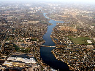
The St. Joseph River is a tributary of Lake Michigan with a length of 206 miles (332 km). The river flows in a generally westerly direction through southern Michigan and northern Indiana, United States, to its terminus on the southeast shore of the lake. It drains a primarily rural farming area in the watershed of Lake Michigan. It was enormously important to Native Americans and greatly aided in the colonial exploration, settlement and administration of New France and the nascent United States as a canoe route between Lake Michigan and the watershed of the Mississippi River.

<span class="mw-page-title-main">Indiana State Road 13</span> Highway in Indiana

State Road 13 (SR 13) is a north–south state road in the US state of Indiana. The southern terminus is at an intersection with U.S. Highway 36 and SR 67, in the town of Fortville, and its northern terminus is at the Michigan state line. At its northern end, signage for SR 13 ends at the interchange with the Indiana Toll Road; the highway continues unsigned for an additional 0.6 miles (0.97 km) running concurrently with US 131 to the state line. The state road runs through six counties in central and north-central Indiana mostly through rural farm fields and small towns.

<span class="mw-page-title-main">U.S. Route 33</span> US Numbered Highway in between Indiana and Virginia, US

U.S. Route 33 (US 33) is a United States Numbered Highway that runs northwest–southeast for 709 miles (1,141 km) from northern Indiana to Richmond, Virginia, passing through Ohio and West Virginia en route. Although most odd-numbered U.S. routes are north–south, US 33 is labeled east–west throughout its route, except in Indiana where it is labeled north–south. It roughly follows a historic trail used by Native Americans from Chesapeake Bay to Lake Michigan.

<span class="mw-page-title-main">Northwest Indiana</span> Sub-region of Indiana, US

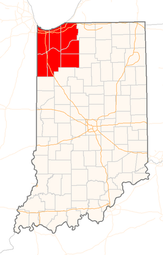
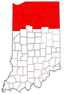
Northwest Indiana, nicknamed The Region after the Calumet Region, is an unofficial region of northern Indiana, United States that is located at the northwestern corner of the state. Though there is no official definition of the region, it is based on the Gary, Indiana Metropolitan Division, which comprises Jasper, Lake, Porter and Newton counties in Indiana, and the Michigan City-La Porte, IN Metropolitan Statistic Area, which comprises LaPorte, with unofficial definitions also including Starke and Pulaski counties. This region neighbors Lake Michigan and parts of it are in the Chicago metropolitan area. According to the 2020 Census, the largest definition of Northwest Indiana has a population of 866,965 and is the state's second largest urban area after the Indianapolis Metropolitan Area. It is also the home of the Indiana Dunes, parts of which have been preserved through conservation efforts. The town of Ogden Dunes houses the Hour Glass, a museum showcasing the ecological and conservation efforts of O. D. Frank.

<span class="mw-page-title-main">Area code 219</span> Area code that serves northwest Indiana

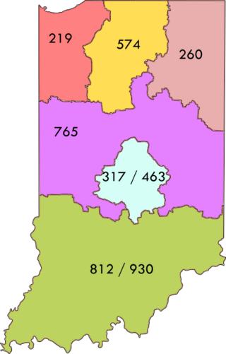
Area code 219 is a telephone area code in the North American Numbering Plan for Northwest Indiana, including the state's portion of the Chicago metropolitan area. The numbering plan area includes the cities of Schererville, Chesterton, Lake Station, Lowell, Crown Point, Cedar Lake, Hobart, Whiting, Gary, Hammond, East Chicago, Merrillville, Munster, Griffith, Highland, Portage, Valparaiso, Michigan City, Ogden Dunes, St. John, La Porte, DeMotte, Roselawn, Kouts, Lake Village, and Rensselaer. 219 is largely co-extensive with the Indiana side of the Chicago metropolitan area, of which it includes the Lake, Porter, La Porte, Newton, and Jasper counties. Service is provided by AT&T, Frontier Communications, and Northwestern Indiana Telephone Company.

<span class="mw-page-title-main">Indiana State Road 15</span> Highway in Indiana

State Road 15 is a north–south state road in northern part of the US state of Indiana. Its southern terminus is at U.S. Highway 35 and SR 22 near Jonesboro and its northern terminus is the Michigan state line, north of Bristol, where the roadway continues north as M-103. It is a surface highway that mostly passes farm fields but passing through a few cities of Marion, Wabash, Warsaw, and Goshen. Running for 94.835 miles (152.622 km) through the state, SR 15 is maintained by the Indiana Department of Transportation (INDOT).

<span class="mw-page-title-main">Area code 260</span> Telephone area code in northeast Indiana, United States

Area code 260 is a telephone area code in the North American Numbering Plan (NANP) for the northeastern part of the U.S. state of Indiana. Cities served include Angola, Auburn, Bluffton, Butler, Columbia City, Decatur, Fort Wayne, Huntington, New Haven, and Wabash.

<span class="mw-page-title-main">Geography of Indiana</span> Overview of the geography of Indiana

The geography of Indiana comprises the physical features of the land and relative location of U.S. State of Indiana. Indiana is in the north-central United States and borders on Lake Michigan. Surrounding states are Michigan to the north and northeast, Illinois to the west, Kentucky to the south, and Ohio to the east. The entire southern boundary is the Ohio River.

<span class="mw-page-title-main">South Bend–Mishawaka metropolitan area</span> Combined Statistical Area in the United States

The South Bend–Mishawaka Metropolitan Statistical Area, sometimes referred to as Michiana, as defined by the United States Census Bureau, is an area consisting of two counties – one in northern Indiana and one in southwest Michigan (Cass), anchored by the cities of South Bend and Mishawaka in Indiana. As of the 2010 census, the MSA had a population of 319,224.

<span class="mw-page-title-main">County Road 17 (Elkhart County, Indiana)</span> Highway in Elkhart County, Indiana, US

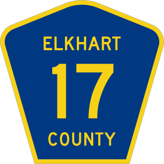
County Road 17 (CR 17) is a 23.08-mile-long (37.14 km) north–south county highway in Elkhart County, Indiana. It is currently undergoing improvements to become a four-lane divided road with non-limited traffic. CR 17 begins at the state line, connecting with state highway M-217 in Michigan. The roadway enters Indiana and becomes CR 17. Currently the improved section of CR 17 ends between CR 40 and CR 38.

<span class="mw-page-title-main">U.S. Route 33 in Indiana</span> Highway in Indiana

U.S. Route 33 (US 33) is part of the United States Numbered Highway System that runs from Richmond, Virginia, to Elkhart of the US state of Indiana. In Indiana, it is a state road that enters the state at the Ohio state line between Willshire, Ohio, and Pleasant Mills, Indiana. The 106.217 miles (170.940 km) of US 33 that lie within Indiana serve as a major conduit. All of the highway is listed on the National Highway System. Various sections are rural two-lane highway, urbanized four-lane divided expressway and the Lincoln Highway. The northernmost community along the highway is Elkhart. The highway ends at an interchange in southern Elkhart after serving the northeastern region of Indiana. US 33 passes through farm fields and urban areas.

<span class="mw-page-title-main">Indiana</span> U.S. state

Indiana is a state in the Midwestern region of the United States. It borders Lake Michigan to the northwest, Michigan to the north and northeast, Ohio to the east, the Ohio River and Kentucky to the south and southeast, and the Wabash River and Illinois to the west. Nicknamed "the Hoosier State", Indiana is the 38th-largest by area and the 17th-most populous of the 50 states. Its capital and largest city is Indianapolis. Indiana was admitted to the United States as the 19th state on December 11, 1816.

References

  1. "2020 / 2021 Estimated Fiscal Year Visits - Indiana State Parks" (PDF). Indiana Department of Natural Resources . Retrieved January 26, 2024.
  2. Mack, Justin L. (March 8, 2019). "Looking back at Indiana's complicated relationship with time: Why Indiana observes daylight saving time". The Indianapolis Star. Retrieved January 26, 2024.
  3. Kasarda, Bob (February 3, 2018). "What's up with that? Where did the term 'Da Region' come from?". The Times of Northwest Indiana . Retrieved February 17, 2024.
  4. "QuickFacts - Fort Wayne city, Indiana". United States Census Bureau. 2020. Retrieved 2022-07-03.
  5. "QuickFacts - South Bend city, Indiana". United States Census Bureau. 2020. Retrieved 2022-07-03.
  6. "QuickFacts - Hammond city, Indiana". United States Census Bureau. 2020. Retrieved 2022-07-03.
  7. "QuickFacts - Gary city, Indiana". United States Census Bureau. 2020. Retrieved 2022-07-03.
  8. "QuickFacts - Elkhart city, Indiana". United States Census Bureau. 2020. Retrieved 2022-07-03.
  9. "QuickFacts - Mishawaka city, Indiana". United States Census Bureau. 2020. Retrieved 2022-07-03.
  10. "QuickFacts - Portage city, Indiana". United States Census Bureau. 2020. Retrieved 2022-07-03.
  11. "QuickFacts - Merrillville town, Indiana". United States Census Bureau. 2020. Retrieved 2022-07-03.
  12. "QuickFacts - Goshen city, Indiana". United States Census Bureau. 2020. Retrieved 2022-07-03.
  13. "QuickFacts - Valparaiso city, Indiana". United States Census Bureau. 2020. Retrieved 2022-07-03.
  14. United States Census Bureau. "Census of Population and Housing" . Retrieved July 3, 2022.
  15. https://www.census.gov/quickfacts/table/PST045215/18179,18169,18069,18149,18131,18099 [ dead link ]
  16. "Census Demographics".
  17. "The Twelve Largest Amish Settlements". Young Center for Anabaptist and Pietist Studies, Elizabethtown College. 2008. Retrieved October 25, 2013.
  18. "American English Dialects" . Retrieved 2013-10-26.
  19. Haynie, Devon (March 15, 2009). "Hoosier dialects difficult to define". The Journal Gazette. Retrieved October 26, 2013.
  20. The Times of Northwest Indiana (2012-01-03). "U.S. steel production up nearly 8 percent in 2011" . Retrieved 2013-10-25.
  21. Catlin, Robert A. (1993). Racial politics and urban planning: Gary, Indiana, 1980-1989. University Press of Kentucky. ISBN   0813117984. OL   1737844M.
  22. NiSource, Inc. (1999-10-14). "U.S. Steel - Primary Energy Cogeneration Plant at Gary Works Wins National Recognition" . Retrieved 2013-10-25.
  23. Ports of Indiana. "Burns Harbor Executive Summary" . Retrieved 2013-10-25.
  24. Grace College and Seminary. "Orthopaedic Regulatory and Clinical Affairs (ORCA)" . Retrieved 2013-10-25.
  25. Roadshow for Growth and Holly Allen (2013-05-24). "Infographic: Meet the RV Capital of the World" . Retrieved 2013-10-25.
  26. Ross, Doug (October 14, 2021). "$1.5 billion solar project being planted in NWI". The Times of Northwest Indiana . Retrieved March 11, 2024.
  27. BP. "Whiting Refinery Facility Fact Sheet" (PDF). Retrieved 2013-10-25.
  28. Gibson, London (July 27, 2021). "Scrub Hub: How much electricity does an Indiana wind turbine produce?". The Indianapolis Star. Retrieved March 11, 2024.
  29. Carnes, Terry (June 8, 2023). "Largest Indiana Private Companies". Indianapolis Business Journal . Retrieved May 2, 2024.
  30. 1 2 3 4 5 6 7 8 Higgins, Will (January 30, 2019). "They were born in a small town. Meet 48 famous (or otherwise interesting) Hoosiers". The Indianapolis Star . Retrieved February 4, 2024.
  31. 1 2 Mitchell, Dawn (August 7, 2019). "Dillinger, Dean and more: 12 famous graves in Indiana". The Indianapolis Star. Retrieved February 4, 2024.
  32. 1 2 3 4 5 Murphy, Marin (August 14, 2023). "Famous Hoosiers: Actors and actresses who made their start in the 'Crossroads of America'". WANE-TV . Retrieved February 4, 2024.
  33. Marini, Glenn (May 6, 2023). "DaMarcus Beasley inducted into National Soccer Hall of Fame". WANE-TV . Retrieved February 4, 2024.
  34. Fountain, Nigel (November 10, 2023). "Frank Borman obituary". The Guardian . Retrieved February 4, 2024.
  35. "Pete Buttigieg Fast Facts". CNN . May 12, 2023. Retrieved February 4, 2024.
  36. "New road signs in Gary direct visitors to Jackson 5's childhood home". Chicago Sun-Times . Associated Press. May 16, 2021. Retrieved February 4, 2024.
  37. Cieply, Michael (May 26, 2008). "Sydney Pollack, Film Director, Dies at 73". The New York Times . Retrieved February 4, 2024.
  38. Pete, Joseph S. (August 18, 2023). "Gregg Popovich talks up Region roots while being inducted into Basketball Hall of Fame". The Times of Northwest Indiana . Retrieved February 4, 2024.
  39. "Woodson's hometown proud". The Beaver County Times . Associated Press. July 14, 2009. Retrieved February 4, 2024.

41°10′N86°0′W / 41.167°N 86.000°W / 41.167; -86.000