Clay County, Indiana

Last updated

Clay County
Clay County Courthouse, Brazil.jpg
Clay County Courthouse, Brazil
Map of Indiana highlighting Clay County.svg
Location within the U.S. state of Indiana
Indiana in United States.svg
Indiana's location within the U.S.
Coordinates: 39°24′N87°07′W / 39.4°N 87.11°W / 39.4; -87.11
CountryFlag of the United States.svg United States
StateFlag of Indiana.svg  Indiana
FoundedFebruary 12, 1825
Named for Henry Clay
Seat Brazil
Largest cityBrazil
Area
  Total360.32 sq mi (933.2 km2)
  Land357.54 sq mi (926.0 km2)
  Water2.78 sq mi (7.2 km2)  0.77%
Population
 (2020)
  Total26,466
  Density73/sq mi (28/km2)
Time zone UTC−5 (Eastern)
  Summer (DST) UTC−4 (EDT)
Congressional district 8th
Website www.claycountyin.gov
Indiana county number 11

Clay County is a county located in the U.S. state of Indiana. As of 2020, the population was 26,466. [1] The county seat is Brazil. [2]

Contents

Clay County is included in the Terre Haute, Indiana, Metropolitan Statistical Area.

History

The Indiana Legislature mandated Clay County in 1825, with territory partitioned from Owen, Putnam, Sullivan, and Vigo counties. Its name honors Henry Clay, [3] a famous antebellum American statesman.

The first Courthouse was built in the newly platted town of Bowling Green in 1828. It was a two-story structure of hand-hewn logs.

By the late 1830s Clay County had grown to the extent that the first Courthouse could no longer provide adequate facilities. Therefore, a second Courthouse was constructed near the first Courthouse. This two-story brick structure served until destroyed by fire on November 30, 1851.

By the 1860s the towns of Harmony, Knightsville, and Brazil were growing rapidly, due in part to their location along the National Road, and also because of the many coal companies in that area. An effort to move the county seat of government to a more central location, which had begun in the 1850s, grew stronger creating controversy among citizens. In the 1860s citizens in the northern section of Clay County became more organized in their efforts. In 1871 brothers Robert and John Stewart donated land along the National Road in Brazil for a new courthouse. $5,300 was also raised by citizens in the area to entice the commissioners to move the seat of government from Bowling Green to Brazil. This amount was reportedly the value of the existing courthouse and grounds, thus defusing opponents' argument that abandoning the present courthouse would be a waste of taxpayers money. The relocation efforts, which began in 1871, were challenged in the Supreme Court. The relocation was finally granted in 1876.

In 1912 John W. Gaddis, a prominent architect in Vincennes, Indiana, entered into a contract with the County Commissioners to design, plan, and oversee the construction of a new courthouse. The construction bid of W.H. Bailey and Charles A. Koemer of Louisville, Kentucky was accepted in 1912 with the cornerstone being laid in the fall of 1912. Gaddis had completed several others: in Fairfield and Robinson, Illinois: Perryville, Missouri and two in Indiana, the Putnam County Courthouse in Greencastle (1905) and the Huntington County Courthouse (1906) in Huntington, which are also in Classical Revival mode.

The Clay County Courthouse, built in 1913–1914, is one of the most historically and architecturally significant buildings in Brazil and Clay County, Indiana. Built in Classical Revival style of architecture, it is the only building in Clay County holding county government offices and records. It is also located alongside the famed National Road (Cumberland Trail). The present building is the fifth Clay County Courthouse. [ citation needed ]

Geography

According to the 2010 census, the county has a total area of 360.32 square miles (933.2 km2), of which 357.54 square miles (926.0 km2) (or 99.23%) is land and 2.78 square miles (7.2 km2) (or 0.77%) is water. [4]

Communities

City

Towns

Census-designated place

Unincorporated communities

Townships

Adjacent counties

Education

The county has two high schools: Northview High School (grades 9–12) and Clay City High School (grades 7–12). There are 7 elementary schools: Van Buren Elementary, Jackson Township Elementary, Staunton Elementary, Meridian Street Elementary, Forest Park Elementary, East Side Elementary and Clay City Elementary. The Clay Community School Corporation [5] is located in Brazil.

Transportation

Major highways

Airport

The county contains one public-use airport: Brazil Clay County Airport (0I2), serving Brazil, Indiana. [6]

Climate and weather

Brazil, Indiana
Climate chart (explanation)
J
F
M
A
M
J
J
A
S
O
N
D
 
 
2.5
 
 
36
19
 
 
2.3
 
 
42
24
 
 
3.7
 
 
54
33
 
 
4.1
 
 
66
43
 
 
4.8
 
 
76
52
 
 
4.3
 
 
84
61
 
 
4.9
 
 
87
65
 
 
4.5
 
 
85
63
 
 
3.1
 
 
79
56
 
 
3.1
 
 
68
45
 
 
4.3
 
 
53
36
 
 
3.5
 
 
40
25
Average max. and min. temperatures in °F
Precipitation totals in inches
Source: The Weather Channel [7]
Metric conversion
J
F
M
A
M
J
J
A
S
O
N
D
 
 
65
 
 
2
−7
 
 
57
 
 
6
−4
 
 
94
 
 
12
1
 
 
104
 
 
19
6
 
 
121
 
 
24
11
 
 
108
 
 
29
16
 
 
124
 
 
31
18
 
 
114
 
 
29
17
 
 
78
 
 
26
13
 
 
77
 
 
20
7
 
 
108
 
 
12
2
 
 
89
 
 
4
−4
Average max. and min. temperatures in °C
Precipitation totals in mm

In recent years, average temperatures in Brazil have ranged from a low of 19 °F (−7 °C) in January to a high of 87 °F (31 °C) in July, although a record low of −25 °F (−32 °C) was recorded in January 1994 and a record high of 109 °F (43 °C) was recorded in July 1936. Average monthly precipitation ranged from 2.25 inches (57 mm) in February to 4.89 inches (124 mm) in July. [7]

Government

The county government is a constitutional body, and is granted specific powers by the Constitution of Indiana, and by the Indiana Code.

County Council: The county council is the legislative branch of the county government and controls all the spending and revenue collection in the county. Representatives are elected to four-year terms from county districts. They are responsible for setting salaries, the annual budget, and special spending. The council also has limited authority to impose local taxes, in the form of an income and property tax that is subject to state level approval, excise taxes, and service taxes. [8] [9]

Board of Commissioners: The Board of Commissioners serves as the county's executive body. The commissioners are elected county-wide to staggered four-year terms. The Board executes acts of the County Council, collects revenue, and runs the day-to-day functions of the county government. [8] [9]

Court: The county maintains a small claims court that can handle some civil cases. The judge on the court is elected to a term of four years and must be a member of the Indiana Bar Association. The judge is assisted by a constable who is also elected to a four-year term. In some cases, court decisions can be appealed to the state-level circuit court. [9]

County Officials: The county has several other elected offices, including sheriff, coroner, auditor, treasurer, recorder, surveyor, and circuit court clerk. Each of these elected officers serves a term of four years and oversees a different part of county government. Members elected to county government positions are required to declare a party affiliation and to be residents of the county. [9]

Clay County is part of Indiana's 8th congressional district; Indiana Senate districts 38 and 39; [10] and Indiana House of Representatives districts 42, 44 and 46. [11]

Clay County tends to vote Republican. Since 1888, county voters have chosen the Republican Party nominee in 73% (24 of 34) of the elections through 2020.

United States presidential election results for Clay County, Indiana [12]
Year Republican Democratic Third party
No.%No.%No.%
2020 9,49977.35%2,55220.78%2301.87%
2016 8,53175.26%2,30620.34%4984.39%
2012 7,09665.67%3,46032.02%2492.30%
2008 6,26755.00%4,95443.48%1741.53%
2004 7,36168.26%3,33330.91%890.83%
2000 6,39362.94%3,60535.49%1601.58%
1996 4,85849.00%3,60536.36%1,45214.64%
1992 4,69646.20%3,30632.53%2,16221.27%
1988 5,85260.77%3,72438.67%530.55%
1984 6,95764.87%3,70734.56%610.57%
1980 6,98059.09%4,36336.94%4693.97%
1976 5,67450.37%5,43348.23%1581.40%
1972 7,14665.34%3,74234.21%490.45%
1968 5,74350.83%3,95635.02%1,59914.15%
1964 5,41245.00%6,52854.28%860.72%
1960 7,43457.92%5,34241.62%580.45%
1956 7,30255.91%5,72043.79%390.30%
1952 7,11853.31%6,07845.52%1551.16%
1948 5,65447.49%5,96550.10%2862.40%
1944 6,68853.28%5,72145.57%1441.15%
1940 7,76851.40%7,25548.00%910.60%
1936 6,33543.15%8,23556.09%1130.77%
1932 5,34338.67%8,15158.99%3242.34%
1928 7,10356.19%5,35842.39%1801.42%
1924 5,95548.86%5,34943.88%8857.26%
1920 6,12948.20%5,61244.13%9757.67%
1916 3,10242.82%3,43547.42%7079.76%
1912 1,49420.45%3,29745.12%2,51634.43%
1908 3,76643.79%4,20448.88%6317.34%
1904 4,00548.01%3,56542.74%7729.25%
1900 3,87346.11%4,11448.98%4124.91%
1896 3,82345.55%4,48253.40%881.05%
1892 3,10542.79%3,55849.04%5938.17%
1888 3,71148.12%3,77348.92%2282.96%

Demographics

Historical population
CensusPop.Note
1830 1,616
1840 5,567244.5%
1850 7,94442.7%
1860 12,16153.1%
1870 19,08456.9%
1880 25,85435.5%
1890 30,53618.1%
1900 34,28512.3%
1910 32,535−5.1%
1920 29,447−9.5%
1930 26,479−10.1%
1940 25,365−4.2%
1950 23,918−5.7%
1960 24,2071.2%
1970 23,933−1.1%
1980 24,8623.9%
1990 24,705−0.6%
2000 26,5567.5%
2010 26,8901.3%
2020 26,466−1.6%
2023 (est.)26,460 [13] 0.0%
US Decennial Census [14]
1790-1960 [15] 1900-1990 [16]
1990-2000 [17] 2010 [18]

As of the 2010 United States Census, there were 26,890 people, 10,447 households, and 7,454 families in the county. [19] The population density was 75.2 inhabitants per square mile (29.0/km2). There were 11,703 housing units at an average density of 32.7 per square mile (12.6/km2). [4] The racial makeup of the county was 97.8% white, 0.3% black or African American, 0.2% Asian, 0.2% American Indian, 0.5% from other races, and 0.9% from two or more races. Those of Hispanic or Latino origin made up 1.1% of the population. [19] In terms of ancestry, 29.2% were German, 20.2% were American, 12.8% were Irish, and 11.0% were English. [20]

Of the 10,447 households, 33.4% had children under the age of 18 living with them, 55.9% were married couples living together, 10.7% had a female householder with no husband present, 28.6% were non-families, and 24.0% of all households were made up of individuals. The average household size was 2.54 and the average family size was 2.99. The median age was 39.9 years. [19]

The median income for a household in the county was $47,697 and the median income for a family was $52,907. Males had a median income of $40,671 versus $31,331 for females. The per capita income for the county was $20,569. About 9.0% of families and 12.5% of the population were below the poverty line, including 21.9% of those under age 18 and 6.7% of those age 65 or over. [21]

2020 census

Clay County Racial Composition [22]
RaceNum.Perc.
White (NH)24,88094%
Black or African American (NH)1290.5%
Native American (NH)430.2%
Asian (NH)910.3%
Pacific Islander (NH)60.02%
Other/Mixed (NH)8573.2%
Hispanic or Latino 4601.73%

See also

Related Research Articles

<span class="mw-page-title-main">Wabash County, Indiana</span> County in Indiana, United States

Wabash County is a county located in the northern central part of the U.S. state of Indiana. As of 2020, the population was 30,976. The county seat is Wabash.

<span class="mw-page-title-main">Tipton County, Indiana</span> County in Indiana, United States

Tipton County is a county in the U.S. state of Indiana, located north of the state capital of Indianapolis. According to the 2020 census, it had a population of 15,359. Its county seat is Tipton. The county has four incorporated towns with a total population of about 7,000, as well as many small unincorporated communities. It is divided into six townships which provide local services. Three Indiana state roads and one U.S. Route cross the county, as do two railroad lines. Before the arrival of non-indigenous settlers in the early 19th century, the area was inhabited by several Native American tribes. The county was officially established in 1844, one of the last Indiana counties to be settled. Tipton and Howard Counties were established by the same legislative action on January 15.

<span class="mw-page-title-main">Tippecanoe County, Indiana</span> County in Indiana, United States

Tippecanoe County is located in the west-central portion of the U.S. state of Indiana about 22 miles east of the Illinois state line and less than 50 miles from the Chicago and the Indianapolis metro areas. As of the 2020 census, the population was 186,251. The county seat and largest city is Lafayette. It was created in 1826 from Wabash County portion of New Purchase and unorganized territory.

<span class="mw-page-title-main">Spencer County, Indiana</span> County in Indiana, United States

Spencer County is a county located in the U.S. state of Indiana. As of the 2020 census, the population was 19,810. The county seat is Rockport. Despite not being in the Owensboro Metropolitan Area, the entire riverfront of the city of Owensboro, Kentucky borders the southern tip of the county.

<span class="mw-page-title-main">Shelby County, Indiana</span> County in Indiana, United States

Shelby County is a county in the U.S. state of Indiana. As of the 2020 United States Census, the population was 45,055. The county seat is Shelbyville.

<span class="mw-page-title-main">Randolph County, Indiana</span> County in Indiana, United States

Randolph County is a county located in the central section of U.S. state of Indiana, on its eastern border with Ohio. As of 2020, the population was 24,502. The county seat is Winchester.

<span class="mw-page-title-main">Parke County, Indiana</span> County in Indiana, United States

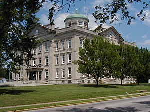
Parke County lies in the western part of the U.S. state of Indiana along the Wabash River. The county was formed in 1821 out of a portion of Vigo County. According to the 2020 census, the population was 16,156. The county seat is Rockville.

<span class="mw-page-title-main">Owen County, Indiana</span> County in Indiana, United States

Owen County is a county in the U.S. state of Indiana. In 1920 the United States Census Bureau calculated the mean center of U.S. population to fall within this county. As of the 2020 United States Census, it had a population of 21,321. Its county seat is Spencer.

<span class="mw-page-title-main">Orange County, Indiana</span> County in Indiana, United States

Orange County is located in southern Indiana in the United States. As of 2020, its population was 19,867. The county seat is Paoli. The county has four incorporated settlements with a total population of about 8,600, as well as several small unincorporated communities. It is divided into 10 townships which provide local services. One U.S. route and five Indiana state roads pass through or into the county.

<span class="mw-page-title-main">Ohio County, Indiana</span> County in Indiana, United States

Ohio County is a county located in southeastern Indiana. With a 2020 population of 5,940, and an area of just 87 square miles, Ohio County is the smallest county in Indiana by area and the least populous. The county seat and only incorporated municipality is Rising Sun. The county was officially established in 1844 and was one of the last Indiana counties to be created. Ohio County borders the state of Kentucky across the Ohio River for which it was named. It is part of the Cincinnati, OH-KY-IN Metropolitan Statistical Area. The county is divided into four townships which provide local services. Three state roads pass through or into the county.

<span class="mw-page-title-main">Newton County, Indiana</span> County in Indiana, United States

Newton County is a county located near the northwestern corner of the U.S. state of Indiana. As of 2020, the population was 13,830. This county is part of Northwest Indiana as well as the Chicago metropolitan area. The county seat is Kentland. The county is divided into 10 townships which provide local services.

<span class="mw-page-title-main">Morgan County, Indiana</span> County in Indiana, United States

Morgan County is a county located in the U.S. state of Indiana. As of the 2020 United States Census, the population was 71,780. The county seat is Martinsville.

<span class="mw-page-title-main">Madison County, Indiana</span> County in Indiana, United States

Madison County is a county in the U.S. state of Indiana. The 2020 census states the population is standing at 130,129. The county seat since 1836 has been Anderson, one of three incorporated cities within the county.

<span class="mw-page-title-main">Grant County, Indiana</span> County in Indiana, United States

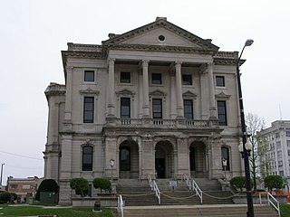
Grant County is a county in central Indiana in the United States Midwest. At the time of the 2020 census, the population was 66,674. The county seat is Marion. Important paleontological discoveries, dating from the Pliocene epoch, have been made at the Pipe Creek Sinkhole in Grant County.

<span class="mw-page-title-main">Delaware County, Indiana</span> County in Indiana, United States

Delaware County is a county in the east central portion of the U.S. state of Indiana. As of 2020, the population was 111,903. The county seat is Muncie.

<span class="mw-page-title-main">Decatur County, Indiana</span> County in Indiana, United States

Decatur County is a county in the U.S. state of Indiana. As of the 2020 United States Census, the population was 26,472. The county seat is Greensburg.

<span class="mw-page-title-main">Cass County, Indiana</span> County in Indiana, United States

Cass County is a county located in the U.S. state of Indiana. As of the 2020 United States Census, its population was 37,870. The county seat is Logansport. Cass County comprises the Logansport, IN Micropolitan Statistical Area.

<span class="mw-page-title-main">Carroll County, Indiana</span> County in Indiana, United States

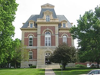
Carroll County is a county located in the U.S. state of Indiana. As of the 2020 United States Census, the population was 20,306. The county seat is Delphi.

<span class="mw-page-title-main">Benton County, Indiana</span> County in Indiana, United States

Benton County is located in the northwest part of the U.S. state of Indiana, along the border with Illinois. As of 2020, the county's population was 8,719. It contains six incorporated towns as well as several small unincorporated settlements; it is divided into 11 townships which provide local services. The county seat is Fowler.

<span class="mw-page-title-main">Bartholomew County, Indiana</span> County in Indiana, United States

Bartholomew County is a county located in the U.S. state of Indiana. The population was 82,208 at the 2020 census. The county seat is Columbus. The county was determined by the U.S. Census Bureau to be home to the mean center of U.S. population in 1900.

References

Specific
  1. "Clay County, Indiana". United States Census Bureau . Retrieved May 30, 2023.
  2. "Find a County". National Association of Counties. Retrieved June 7, 2011.
  3. Gannett, Henry (1905). The Origin of Certain Place Names in the United States. Govt. Print. Off. p.  83.
  4. 1 2 "Population, Housing Units, Area, and Density: 2010 - County". US Census Bureau. Archived from the original on February 12, 2020. Retrieved July 10, 2015.
  5. Clay Community Schools website
  6. Public and Private Airports, Clay County, Indiana
  7. 1 2 "Monthly Averages for Brazil IN". The Weather Channel. Retrieved January 27, 2011.
  8. 1 2 Indiana Code. "Title 36, Article 2, Section 3". IN.gov. Retrieved September 16, 2008.
  9. 1 2 3 4 Indiana Code. "Title 2, Article 10, Section 2" (PDF). IN.gov. Retrieved September 16, 2008.
  10. "Indiana Senate Districts". State of Indiana. Retrieved January 23, 2011.
  11. "Indiana House Districts". State of Indiana. Retrieved January 23, 2011.
  12. Leip, David. "Dave Leip's Atlas of U.S. Presidential Elections" . Retrieved May 14, 2018.
  13. "Annual Estimates of the Resident Population for Counties: April 1, 2020 to July 1, 2023". United States Census Bureau. Retrieved April 2, 2024.
  14. "US Decennial Census". US Census Bureau. Retrieved July 10, 2014.
  15. "Historical Census Browser". University of Virginia Library. Archived from the original on August 11, 2012. Retrieved July 10, 2014.
  16. "Population of Counties by Decennial Census: 1900 to 1990". US Census Bureau. Retrieved July 10, 2014.
  17. "Census 2000 PHC-T-4. Ranking Tables for Counties: 1990 and 2000" (PDF). US Census Bureau. Retrieved July 10, 2014.
  18. "Clay County QuickFacts". US Census Bureau. Archived from the original on June 7, 2011. Retrieved September 17, 2011.
  19. 1 2 3 "Profile of General Population and Housing Characteristics: 2010 Demographic Profile Data". US Census Bureau. Archived from the original on February 13, 2020. Retrieved July 10, 2015.
  20. "Selected Social Characteristics in the United States – 2006-2010 American Community Survey 5-Year Estimates". US Census Bureau. Archived from the original on February 14, 2020. Retrieved July 10, 2015.
  21. "Selected Economic Characteristics – 2006-2010 American Community Survey 5-Year Estimates". US Census Bureau. Archived from the original on February 14, 2020. Retrieved July 10, 2015.
  22. "P2 HISPANIC OR LATINO, AND NOT HISPANIC OR LATINO BY RACE – 2020: DEC Redistricting Data (PL 94-171) – Clay County, Indiana".
General

39°24′N87°07′W / 39.40°N 87.11°W / 39.40; -87.11