Asheboro is a city in and the county seat of Randolph County, North Carolina, United States. The population was 25,012 at the 2010 census. It is part of the Greensboro–High Point Metropolitan Area of the Piedmont Triad and is home of the state-owned North Carolina Zoo.
Jacksonburg is an unincorporated community in Harrison Township, Wayne County, in the U.S. state of Indiana.

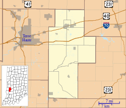
Art is an unincorporated community in Perry Township, Clay County, Indiana. It is part of the Terre Haute Metropolitan Statistical Area.
Asherville is an unincorporated community in Jackson Township, Clay County, Indiana. It is part of the Terre Haute Metropolitan Statistical Area.
Benwood is an unincorporated community in Van Buren Township, Clay County, Indiana, United States. It is part of the Terre Haute Metropolitan Statistical Area. Benwood is located at 39°33′40″N87°06′51″W.
Billtown is an unincorporated community in Posey Township, Clay County, Indiana. It is part of the Terre Haute Metropolitan Statistical Area.

Bowling Green is an unincorporated community in Washington Township, Clay County, Indiana. It is part of the Terre Haute Metropolitan Statistical Area.
Cardonia is an unincorporated community in Van Buren Township, Clay County, Indiana. It is part of the Terre Haute Metropolitan Statistical Area.

Cloverland is an unincorporated community in Posey Township, Clay County, Indiana. It is part of the Terre Haute Metropolitan Statistical Area.

Coalmont is an unincorporated community and census-designated place in Lewis Township, Clay County, Indiana, United States. It is part of the Terre Haute Metropolitan Statistical Area. As of the 2010 census it had a population of 402.
Hoosierville is an unincorporated community in Jackson Township, Clay County, Indiana. It is part of the Terre Haute Metropolitan Statistical Area.
Howesville is an unincorporated community in Lewis Township, Clay County, Indiana. It is part of the Terre Haute Metropolitan Statistical Area.
Perth is an unincorporated community in Dick Johnson Township, Clay County, Indiana. It is part of the Terre Haute Metropolitan Statistical Area.

Saline City is an unincorporated community in Sugar Ridge Township, Clay County, Indiana. It is part of the Terre Haute Metropolitan Statistical Area.
Stearleyville is an unincorporated community in Jackson Township, Clay County, Indiana.

Peppertown is an unincorporated community in Salt Creek Township, Franklin County, Indiana.

Shepardsville is an unincorporated census-designated place in northeastern Fayette Township, Vigo County, in the U.S. state of Indiana. It lies along Trinity Ave. north of the city of Terre Haute, the county seat of Vigo County. Its elevation is 502 feet (153 m), and it is located at 39°36′3″N87°25′3″W. Although Shepardsville is unincorporated, it has a post office, with the ZIP code of 47880.

Middlebury is an unincorporated community in Harrison Township, Clay County, Indiana. It is part of the Terre Haute Metropolitan Statistical Area.

Lena is an unincorporated community in southern Jackson Township, Parke County, in the U.S. state of Indiana. A portion of Lena also extends into Clay County, just north of Carbon. This portion of Lena is referred to as Marysville.
Whitehall is an unincorporated community in Clay Township, Owen County, in the U.S. state of Indiana.


