
Clay County is a county located in the U.S. state of Indiana. As of 2010, the population was 26,890. The county seat is Brazil.
Vigo County is a county on the western border of the U.S. state of Indiana. According to the 2010 United States Census, the population was 107,848. The county seat is Terre Haute.

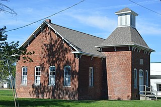
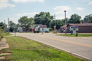
West Terre Haute is a town in Sugar Creek Township, Vigo County, Indiana, on the western side of the Wabash River near Terre Haute. The population was 2,236 at the 2010 census. It is part of the Terre Haute Metropolitan Statistical Area. Bethany Congregational Church was placed on the National Register of Historic Places in 2003.

Prairieton is an unincorporated community in Prairieton Township, Vigo County, in the U.S. state of Indiana. Today, due to its proximity to both Terre Haute's southern shopping district and the Terre Haute Federal Penitentiary, it has mostly become a commuter town, with fewer than ten businesses within its "city limits".

Lost Creek Township is one of twelve townships in Vigo County, Indiana, United States. As of the 2010 census, its population was 10,497 and it contained 4,236 housing units. It contains Terre Haute, Indiana's eastern, suburban end, along with the affluent Hulman family ranch and the Terre Haute International Airport originally named after the family. Seelyville, the third largest city in the county, is also located there.
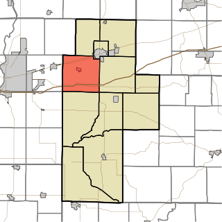
Posey Township is one of eleven townships in Clay County, Indiana. As of the 2010 census, its population was 4,063 and it contained 1,706 housing units.

Sandford is an unincorporated community in Fayette Township, Vigo County, in the U.S. state of Indiana. The community is part of the Terre Haute Metropolitan Statistical Area. A small portion of Sandford, now known as West Sandford or “Stringtown”, is in Illinois.

Lewis, also known as Lewisburg or Centerville, is an unincorporated community in Vigo County, in the U.S. state of Indiana. Originally platted entirely within Vigo County, it has now expanded into adjacent Sullivan County.
New Goshen is a census-designated place (CDP) in Fayette Township, Vigo County, in the U.S. state of Indiana. It is part of the Terre Haute Metropolitan Statistical Area.
Pimento is an unincorporated community in Linton Township, Vigo County, in the U.S. state of Indiana. It is part of the Terre Haute Metropolitan Statistical Area.

Asherville is an unincorporated community in Jackson Township, Clay County, Indiana. It is part of the Terre Haute Metropolitan Statistical Area.

Cloverland is an unincorporated community in Posey Township, Clay County, Indiana. It is part of the Terre Haute Metropolitan Statistical Area.
Howesville is an unincorporated community in Lewis Township, Clay County, Indiana. It is part of the Terre Haute Metropolitan Statistical Area.

Westphalia is an unincorporated community and census-designated place (CDP) in Vigo Township, Knox County, Indiana. As of the 2010 census it had a population of 202.
Prairie Creek is an unincorporated community in southeastern Prairie Creek Township, Vigo County, in the U.S. state of Indiana. Its elevation is 528 feet (161 m), and it is located at 39°16′30″N87°29′50″W. Because the community has had multiple names, the Board on Geographic Names officially decided in favor of "Prairie Creek" in 1959. Although Prairie Creek is unincorporated, it has a post office, with the ZIP code of 47869.
Atherton is an unincorporated community in northern Otter Creek Township, Vigo County, in the U.S. state of Indiana. It is part of the Terre Haute metropolitan area.
Coal Bluff is an unincorporated community in northern Nevins Township, Vigo County, in the U.S. state of Indiana.
Hickory Island is an unincorporated community in Vigo and Clay counties, in the U.S. state of Indiana.
State Line is an unincorporated community in western Sugar Creek Township, Vigo County, in the U.S. state of Indiana.

Whitehall is an unincorporated community in Clay Township, Owen County, in the U.S. state of Indiana.


