Bee Ridge, Indiana

Last updated

Bee Ridge
Location map of Clay County, Indiana.svg
Red pog.svg
Bee Ridge
Location in Clay County
Coordinates: 39°32′13″N87°10′10″W / 39.53694°N 87.16944°W / 39.53694; -87.16944
Country United States
State Indiana
County Clay
Township Dick Johnson
Elevation
640 ft (200 m)
ZIP code
47834
FIPS code 18-04312 [1]
GNIS feature ID430706 [2]

Bee Ridge is a locality with (now or formerly) a church and a school in Dick Johnson Township, Clay County, Indiana. [3] [4] [5] [6] [7] [8] [9] [10] [11] [12] [13]

It is part of the Terre Haute Metropolitan Statistical Area.


Bee Ridge is the location of the Bee Ridge Congregational Christian Church which was founded in 1832. [11] [9] [7] [12]

Geography

Bee Ridge is located at 39°32′13″N87°10′10″W / 39.53694°N 87.16944°W / 39.53694; -87.16944 .

Related Research Articles

<span class="mw-page-title-main">Clay County, Indiana</span> County in Indiana, United States

Clay County is a county located in the U.S. state of Indiana. As of 2020, the population was 26,466. The county seat is Brazil.

<span class="mw-page-title-main">Milan Township, Allen County, Indiana</span> Township in Indiana, United States

Milan Township is one of twenty townships in Allen County, Indiana, United States. Milan Township is located in east central Allen County, with the Maumee River meandering across the township. As of the 2010 census, its population was 3,749. The township is highly rural, with only 1,137 houses in the 2010 census. Many of the residents of Milan Township are Swiss Amish who mostly speak a Low Alemannic Alsatian dialect. Milan township is generally demarcated by Schwartz Road to the west, Notestine Road to the north, Sampson Road to the east, and Gar Creek Road to the south.

<span class="mw-page-title-main">Jackson Township, Parke County, Indiana</span> Township in Indiana, United States

Jackson Township is one of thirteen townships in Parke County, Indiana, United States. As of the 2020 census, its population was 711 and it contained 427 housing units.

<span class="mw-page-title-main">Brown Township, Montgomery County, Indiana</span> Township in Indiana, United States

Brown Township is one of eleven townships in Montgomery County, Indiana, United States. As of the 2020 census, its population was 1,617 and it contained 705 housing units.

<span class="mw-page-title-main">Brazil Township, Clay County, Indiana</span> Township in Indiana, United States

Brazil Township is one of eleven townships in Clay County, Indiana. As of the 2010 census, its population was 8,604 and it contained 3,813 housing units.

<span class="mw-page-title-main">Dick Johnson Township, Clay County, Indiana</span> Township in Indiana, United States

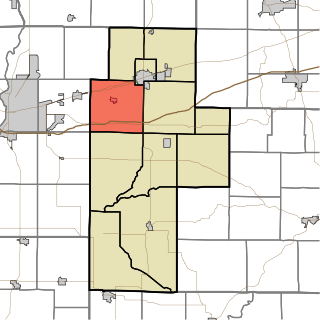
Dick Johnson Township is one of eleven townships in Clay County, Indiana. As of the 2020 census, its population was 1,355 and it contained 576 housing units.

<span class="mw-page-title-main">Jackson Township, Clay County, Indiana</span> Township in Indiana, United States

Jackson Township is one of eleven townships in Clay County, Indiana. As of the 2020 census, its population was 2,839 and it contained 1,187 housing units.

<span class="mw-page-title-main">Posey Township, Clay County, Indiana</span> Township in Indiana, United States

Posey Township is one of eleven townships in Clay County, Indiana. As of the 2020 census, its population was 4,016 and it contained 1,682 housing units.

<span class="mw-page-title-main">Van Buren Township, Clay County, Indiana</span> Township in Indiana, United States

Van Buren Township is one of eleven townships in Clay County, Indiana. As of the 2020 census, its population was 3,203 and it contained 1,415 housing units.

<span class="mw-page-title-main">Marion Township, Owen County, Indiana</span> Township in Indiana, United States

Marion Township is one of thirteen townships in Owen County, Indiana, United States. As of the 2020 census, its population was 922 and it contained 413 housing units.

<span class="mw-page-title-main">Clay Township, Cass County, Indiana</span> Township in Indiana, United States

Clay Township is one of fourteen townships in Cass County, Indiana, United States, and one of the seventeen townships sharing the name in the state. As of the 2020 census, its population was 2,842 and it contained 1,177 housing units.

<span class="mw-page-title-main">Clear Lake Township, Steuben County, Indiana</span> Township in Indiana, United States

Clear Lake Township is one of twelve townships in Steuben County, Indiana, United States. As of the 2020 census, its population was 818, up from 799 at 2010, and it contained 912 housing units. It is the north easternmost township in the state.

Ashboro is an unincorporated community in Sugar Ridge Township, Clay County, Indiana. It is part of the Terre Haute Metropolitan Statistical Area.

<span class="mw-page-title-main">Bowling Green, Indiana</span> Unincorporated community in Indiana, United States

Bowling Green is an unincorporated community in Washington Township, Clay County, Indiana. It is part of the Terre Haute Metropolitan Statistical Area.

<span class="mw-page-title-main">Cloverland, Indiana</span> Unincorporated community in Indiana, United States

Cloverland is an unincorporated community in Posey Township, Clay County, Indiana. It is part of the Terre Haute Metropolitan Statistical Area.

Perth is an unincorporated community in Dick Johnson Township, Clay County, Indiana. It is part of the Terre Haute Metropolitan Statistical Area.

<span class="mw-page-title-main">Saline City, Indiana</span> Unincorporated community in Indiana, United States

Saline City is an unincorporated community in Sugar Ridge Township, Clay County, Indiana. It is part of the Terre Haute Metropolitan Statistical Area.

Stearleyville is an unincorporated community in Jackson Township, Clay County, Indiana.

Lap Corner is an unincorporated community in northern Sugar Ridge Township, Clay County, Indiana, just north of Center Point. It is part of the Terre Haute Metropolitan Statistical Area.

Shady Lane is an unincorporated community in Brazil Township, Clay County, Indiana. It is part of the Terre Haute Metropolitan Statistical Area.

References

  1. "U.S. Census website". United States Census Bureau . Retrieved January 31, 2008.
  2. "Bee Ridge, Indiana". Geographic Names Information System . United States Geological Survey, United States Department of the Interior . Retrieved October 10, 2009.
  3. "Bee Ridge, Township of Dick Johnson, Clay County, Indiana, United States". mindat.
  4. "Dick Johnson Schools | Clay County Genealogical Society". www.ccgsilib.org. Retrieved May 15, 2024.
  5. "Clay,DJohnson,1884.pdf" (PDF). INGenWeb Project.
  6. "Clay County". Genealogy Lady. November 21, 2014. Retrieved May 15, 2024.
  7. 1 2 "The Churches of Clay County, Indiana" (PDF). INGenWeb Project.
  8. Travis, William (1909). A History of Clay County, Indiana: Closing the First Century's History of the County, and Showing the Growth of Its People, Institutions, Industries and Wealth. Lewis Publishing Company. ISBN   978-0-598-73231-6.
  9. 1 2 "Clay County Churches 1 | Clay County Genealogical Society". www.ccgsilib.org. Retrieved May 15, 2024.
  10. "CLAY COUNTY THROUGH THE YEARS". The Brazil Times.
  11. 1 2 "Bee Ridge Congregational Christian Church founded in 1832". The Brazil Times.
  12. 1 2 "Clay County Indiana". genealogytrails.com. Retrieved May 15, 2024.
  13. Bee Ridge appears on the Brazil West U.S. Geological Survey Map.