
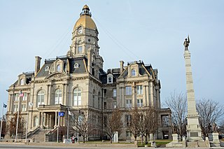
Clay County is a county located in the U.S. state of Indiana. As of 2020, the population was 26,466. The county seat is Brazil.
Vigo County is a county on the western border of the U.S. state of Indiana. According to the 2020 United States Census, it had a population of 106,153. Its county seat is Terre Haute.

Parke County lies in the western part of the U.S. state of Indiana along the Wabash River. The county was formed in 1821 out of a portion of Vigo County. According to the 2020 census, the population was 16,156. The county seat is Rockville.

The Miami are a Native American nation originally speaking one of the Algonquian languages. Among the peoples known as the Great Lakes tribes, they occupied territory that is now identified as north-central Indiana, southwest Michigan, and western Ohio. The Miami were historically made up of several prominent subgroups, including the Piankeshaw, Wea, Pepikokia, Kilatika, Mengakonkia, and Atchakangouen. In modern times, Miami is used more specifically to refer to the Atchakangouen. By 1846, most of the Miami had been forcefully displaced to Indian Territory. The Miami Tribe of Oklahoma are the federally recognized tribe of Miami Indians in the United States. The Miami Nation of Indiana, a nonprofit organization of self-identified descendants of Miamis who were exempted from removal, have unsuccessfully sought separate recognition.

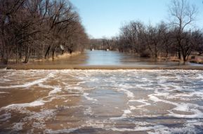
The Wabash and Erie Canal was a shipping canal that linked the Great Lakes to the Ohio River via an artificial waterway. The canal provided traders with access from the Great Lakes all the way to the Gulf of Mexico. Over 460 miles long, it was the longest canal ever built in North America.

The Treaty of St. Mary's may refer to one of six treaties concluded in fall of 1818 between the United States and Natives of central Indiana regarding purchase of Native land. The treaties were
Ouiatenon was a dwelling place of members of the Wea tribe of Native Americans. The name Ouiatenon, also variously given as Ouiatanon, Oujatanon, Ouiatano or other similar forms, is a French rendering of a term from the Wea dialect of the Miami-Illinois language which means "place of the people of the whirlpool", an ethnonym for the Wea. Ouiatenon can be said to refer generally to any settlement of Wea or to their tribal lands as a whole, though the name is most frequently used to refer to a group of extinct settlements situated together along the Wabash River in what is now western Tippecanoe County, Indiana.

Hillsdale is an unincorporated community in Helt Township, Vermillion County, in the U.S. state of Indiana.

Liberty Mills is an unincorporated community on the Eel River in Chester Township, Wabash County, in the U.S. state of Indiana. Proprietor John Comstock (1802–1879) platted the town June 24, 1837. The name Liberty Mills comes from the number of mills the town once operated, including a saw mill, a carding mill, and a distillery, with one of the mills coming from the ‘Liberty’ brand. Its ZIP code is 46946.
Collamer is an unincorporated community in Cleveland Township, Whitley County, Indiana, United States, located on the Eel River and at the intersection of Indiana State Road 14 and Whitley County road 900 W. Smith Rambo platted the town February 9, 1846. Collamer is named after Jacob Collamer, 13th United States Postmaster General.

Wabash Township is one of thirteen townships in Parke County, Indiana, United States. As of the 2020 census, its population was 768 and it contained 325 housing units.

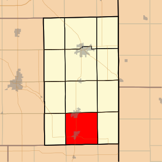
Harrison Township is one of eleven townships in Clay County, Indiana. As of the 2020 census, its population was 2,151 and it contained 1,025 housing units.
Wabash Township is one of twelve townships in Adams County, Indiana. As of the 2020 census, its population was 6,545, up from 6,223 at the 2010 census.
Chili (Cheye-leye) is an unincorporated community and census-designated place in Richland Township, Miami County, in the U.S. state of Indiana.

Tecumseh is an unincorporated census-designated place in eastern Fayette Township, Vigo County, in the U.S. state of Indiana. It is part of the Terre Haute metropolitan area.

Greenville is an unincorporated community in northern Cass Township, Sullivan County, in the U.S. state of Indiana.
Eel River is an unincorporated community in northern Harrison Township, Clay County, Indiana. It is part of the Terre Haute Metropolitan Statistical Area.
Denmark is an unincorporated community in the southwest portion of Marion Township, Owen County, in the U.S. state of Indiana. It lies near the intersection of County Road 1400 West and County Road 150 South, which is a community about fifteen miles west of the city of Spencer, the county seat of Owen County. Its elevation is 722 feet, and it is located at 39°16′11″N87°1′33″W.
Old Town is an extinct town located in Pike Township in Warren County, Indiana, and the original site of what is now the town of West Lebanon.

