Seelyville, Indiana

Last updated

Seelyville, Indiana
Seelyville-Town-Hall-water-tower-in.jpg
Town Hall and water tower
Vigo County Indiana Incorporated and Unincorporated areas Seelyville Highlighted 1868652.svg
Location of Seelyville in Vigo County, Indiana.
Coordinates: 39°29′32″N87°15′59″W / 39.49222°N 87.26639°W / 39.49222; -87.26639
CountryUnited States
State Indiana
County Vigo
Township Lost Creek
Area
[1]
  Total0.91 sq mi (2.35 km2)
  Land0.89 sq mi (2.30 km2)
  Water0.02 sq mi (0.05 km2)
Elevation
[2]
584 ft (178 m)
Population
 (2020)
  Total1,012
  Density1,139.64/sq mi (440.13/km2)
Time zone UTC−5 (Eastern (EST))
  Summer (DST) UTC−4 (EDT)
ZIP code
47878
Area code 812
FIPS code 18-68652 [3]
GNIS feature ID 443203

Seelyville is a town in Lost Creek Township, Vigo County, in the U.S. state of Indiana. [4] The population was 1,029 at the 2010 census. It is part of the Terre Haute Metropolitan Statistical Area.

Contents

History

Seelyville was originally called the "Woodsmills." The town was laid out by Moddisett, the owner of the land north of the Jonas Seely property. When the Terre Haute and Eastern Railroad was built along the south side of town, the small whistle stop station hired Jonas Seely as station master. The name was originally the Seely Station but was later changed to Seelyville Station. [5] The town expanded with the opening of the McKeen coal shaft, one of the earliest operated in the county. After passing through several hands, the mine closed operations in 1879. Others operated into the early 1900s. A post office was established in Seelyville in 1878. [6]

Geography

Seelyville is located at 39°29′32″N87°15′59″W / 39.49222°N 87.26639°W / 39.49222; -87.26639 (39.492188, -87.266466). [7] The town lies east of Terre Haute along U.S. Route 40.

According to the 2010 census, Seelyville has a total area of 0.91 square miles (2.36 km2), of which 0.89 square miles (2.31 km2) (or 97.8%) is land and 0.02 square miles (0.05 km2) (or 2.2%) is water. [8]

Climate

The climate in this area is characterized by hot, humid summers and generally mild to cool winters. According to the Köppen climate classification system, Seelyville has a humid subtropical climate, abbreviated "Cfa" on climate maps. [9]

Demographics

Historical population
CensusPop.Note
1910 1,188
1920 915−23.0%
1930 825−9.8%
1940 807−2.2%
1950 89811.3%
1960 1,11424.1%
1970 1,1957.3%
1980 1,37415.0%
1990 1,090−20.7%
2000 1,1828.4%
2010 1,029−12.9%
2020 1,012−1.7%
U.S. Decennial Census [10]

2010 census

As of the census [11] of 2010, there were 1,029 people, 424 households, and 263 families living in the town. The population density was 1,156.2 inhabitants per square mile (446.4/km2). There were 481 housing units at an average density of 540.4 per square mile (208.6/km2). The racial makeup of the town was 97.8% White, 0.4% African American, 0.2% Native American, 0.2% Asian, 0.2% from other races, and 1.3% from two or more races. Hispanic or Latino of any race were 0.9% of the population.

There were 424 households, of which 31.4% had children under the age of 18 living with them, 44.8% were married couples living together, 12.7% had a female householder with no husband present, 4.5% had a male householder with no wife present, and 38.0% were non-families. 29.2% of all households were made up of individuals, and 10.6% had someone living alone who was 65 years of age or older. The average household size was 2.40 and the average family size was 2.99.

The median age in the town was 36.2 years. 23.2% of residents were under the age of 18; 10.4% were between the ages of 18 and 24; 27.5% were from 25 to 44; 27.5% were from 45 to 64; and 11.4% were 65 years of age or older. The gender makeup of the town was 50.0% male and 50.0% female.

2000 census

As of the census [3] of 2000, there were 1,182 people, 491 households, and 326 families living in the town. The population density was 1,371.4 inhabitants per square mile (529.5/km2). There were 526 housing units at an average density of 610.3 per square mile (235.6/km2). The racial makeup of the town was 98.39% White, 0.68% African American, 0.17% Asian, 0.42% from other races, and 0.34% from two or more races. Hispanic or Latino of any race were 0.85% of the population.

There were 491 households, out of which 32.2% had children under the age of 18 living with them, 53.0% were married couples living together, 9.2% had a female householder with no husband present, and 33.6% were non-families. 27.1% of all households were made up of individuals, and 10.6% had someone living alone who was 65 years of age or older. The average household size was 2.38 and the average family size was 2.90.

In the town, the age distribution of the population shows 24.1% under the age of 18, 8.3% from 18 to 24, 29.5% from 25 to 44, 24.5% from 45 to 64, and 13.6% who were 65 years of age or older. The median age was 37 years. For every 100 females, there were 96.0 males. For every 100 females age 18 and over, there were 95.9 males.

The median income for a household in the town was $35,114, and the median income for a family was $45,167. Males had a median income of $31,000 versus $21,326 for females. The per capita income for the town was $17,588. About 3.5% of families and 7.4% of the population were below the poverty line, including 5.3% of those under age 18 and 14.3% of those age 65 or over.

Notable natives

One of Seelyville's most famous residents was New York Giants outfielder Josh Devore, sometimes referred to as the "Seelyville Speed Demon."

Related Research Articles

<span class="mw-page-title-main">Jamestown, Indiana</span> Town in Indiana, United States

Jamestown is a town in Jackson Township, Boone County and Eel River Township, Hendricks County, Indiana, United States. The population was 958 at the 2010 census.

<span class="mw-page-title-main">Center Point, Indiana</span> Town in Indiana, United States

Center Point is a town in Sugar Ridge Township, Clay County, Indiana, United States. The population was 242 at the 2010 census. It is part of the Terre Haute Metropolitan Statistical Area.

<span class="mw-page-title-main">Staunton, Indiana</span> Town in Indiana, United States

Staunton is a town in Posey Township, Clay County, Indiana, United States. The population was 534 at the 2010 census. It is part of the Terre Haute Metropolitan Statistical Area.

<span class="mw-page-title-main">Mulberry, Indiana</span> Town in Indiana, United States

Mulberry is a town in Madison Township, Clinton County, Indiana, United States. The population was 1,231 at the 2020 census. The town was named for a mulberry tree which grew at the point where it was founded.

<span class="mw-page-title-main">Switz City, Indiana</span> Town in Indiana, United States

Switz City is a town in Fairplay and Grant townships, Greene County, Indiana, United States. The population was 293 at the 2010 census. It is part of the Bloomington, Indiana, Metropolitan Statistical Area.

<span class="mw-page-title-main">Whiteland, Indiana</span> Town in Indiana, United States

Whiteland is a town in Pleasant, Franklin and Clark townships, Johnson County, Indiana, United States. The population was 4,599 at the 2020 census.

<span class="mw-page-title-main">New Market, Indiana</span> Town in Indiana, United States

New Market is a town in Montgomery County, Indiana, in the United States. The population was 559 at the 2020 census, down from 636 in 2010.

<span class="mw-page-title-main">Waveland, Indiana</span> Town in Indiana, United States

Waveland is a town in Brown Township, Montgomery County, in the U.S. state of Indiana. The population was 427 at the 2020 census.

<span class="mw-page-title-main">Winslow, Indiana</span> Town in Indiana, United States

Winslow is a town in Patoka Township, Pike County, in the U.S. state of Indiana. The population was 864 at the 2010 census. It is part of the Jasper Micropolitan Statistical Area.

<span class="mw-page-title-main">Poseyville, Indiana</span> Town in Indiana, United States

Poseyville is a town in Robb Township, Posey County, in the U.S. state of Indiana. The population was 1,045 at the 2010 census.

<span class="mw-page-title-main">Sunman, Indiana</span> Town in Indiana, United States

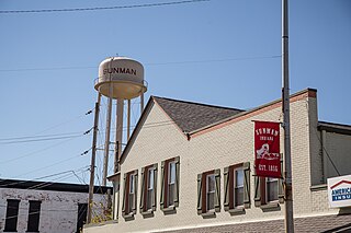
Sunman is a town in Adams Township, Ripley County, in the U.S. state of Indiana. The population was 1,049 at the 2010 census.

<span class="mw-page-title-main">Farmersburg, Indiana</span> Town in Indiana, United States

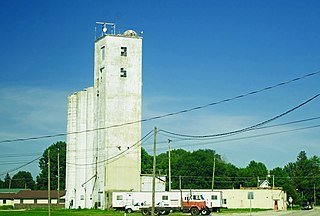
Farmersburg is a town in Curry Township, Sullivan County, Indiana, United States. The population was 1,118 at the 2010 census. It is part of the Terre Haute Metropolitan Statistical Area. The town is adjacent to the Vigo County line and is overshadowed by several large TV and radio transmitter towers.

<span class="mw-page-title-main">Fairview Park, Indiana</span> Town in Indiana, United States

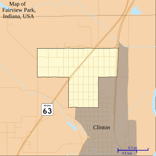
Fairview Park is a town in Clinton Township, Vermillion County, in the U.S. state of Indiana. The population was 1,386 at the 2010 census.

<span class="mw-page-title-main">West Terre Haute, Indiana</span> Town in Indiana, United States

West Terre Haute is a town in Sugar Creek Township, Vigo County, Indiana, on the western side of the Wabash River near Terre Haute. The population was 2,236 at the 2010 census. It is part of the Terre Haute Metropolitan Statistical Area. Bethany Congregational Church was placed on the National Register of Historic Places in 2003.

<span class="mw-page-title-main">Clay Township, Lancaster County, Pennsylvania</span> Township in Pennsylvania, United States

Clay Township is a township in north central Lancaster County, Pennsylvania, United States. The population was 6,887 at the 2020 census.

<span class="mw-page-title-main">Sandy Creek Township, Pennsylvania</span> Township in Pennsylvania, United States

Sandy Creek Township is a township that is located in Mercer County, Pennsylvania, United States. The population was 800 at the time of the 2020 census, an increase from the figure of 795 that was documented in 2010.

<span class="mw-page-title-main">Centre Township, Perry County, Pennsylvania</span> Township in Pennsylvania, United States

Centre Township is a township in Perry County, Pennsylvania, United States. The population was 2,537 at the 2020 census.

<span class="mw-page-title-main">Spring Township, Perry County, Pennsylvania</span> Township in Pennsylvania, United States

Spring Township is a township in Perry County, Pennsylvania, United States. The population was 2,290 at the 2020 census.

<span class="mw-page-title-main">Union Township, Schuylkill County, Pennsylvania</span> Township in Pennsylvania, United States

Union Township is a township that is located in Schuylkill County, Pennsylvania, United States. The population was 1,231 at the time of the 2020 census.

<span class="mw-page-title-main">Lost Creek Township, Vigo County, Indiana</span> Township in Indiana, United States

Lost Creek Township is one of twelve townships in Vigo County, Indiana, United States. As of the 2010 census, its population was 10,497 and it contained 4,236 housing units. It contains Terre Haute, Indiana's eastern, suburban end, along with the affluent Hulman family ranch and the Terre Haute International Airport originally named after the family. Seelyville, the third largest city in the county, is also located there.

References

  1. "2020 U.S. Gazetteer Files". United States Census Bureau. Retrieved March 16, 2022.
  2. "US Board on Geographic Names". United States Geological Survey. October 25, 2007. Retrieved January 31, 2008.
  3. 1 2 "U.S. Census website". United States Census Bureau . Retrieved January 31, 2008.
  4. "Seelyville, Indiana". Geographic Names Information System . United States Geological Survey, United States Department of the Interior . Retrieved July 13, 2016.
  5. "Profile for Seelyville, IN". ePodunk . Retrieved July 13, 2016.
  6. Bradsby, H.C. (1891). History of Vigo County, Indiana, with Biographical Selections. Chicago: S. B. Nelson & Co. pp.  479.
  7. "US Gazetteer files: 2010, 2000, and 1990". United States Census Bureau. February 12, 2011. Retrieved April 23, 2011.
  8. "G001 – Geographic Identifiers – 2010 Census Summary File 1". United States Census Bureau. Archived from the original on February 13, 2020. Retrieved July 25, 2015.
  9. Climate Summary for Seelyville, Indiana
  10. "Census of Population and Housing". Census.gov. Retrieved June 4, 2015.
  11. "U.S. Census website". United States Census Bureau . Retrieved December 11, 2012.