Prairieton Township, Vigo County, Indiana

Last updated
Prairieton Township
Township
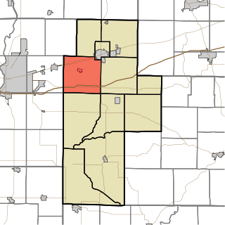
Map highlighting Prairieton Township, Vigo County, Indiana.svg
Location in Vigo County
Coordinates: 39°21′33″N87°30′11″W / 39.35917°N 87.50306°W / 39.35917; -87.50306 Coordinates: 39°21′33″N87°30′11″W / 39.35917°N 87.50306°W / 39.35917; -87.50306
Country United States
State Indiana
County Vigo
Government
  Type Indiana township
Area
  Total 18.51 sq mi (47.9 km2)
  Land 17.83 sq mi (46.2 km2)
  Water 0.68 sq mi (1.8 km2)  3.67%
Elevation 459 ft (140 m)
Population (2010)
  Total 1,222
  Density 68.6/sq mi (26.5/km2)
ZIP codes47870
GNIS feature ID 453775

Prairieton Township is one of twelve townships in Vigo County, Indiana, United States. As of the 2010 census, its population was 1,222 and it contained 517 housing units. [1]

A civil township is a widely used unit of local government in the United States that is subordinate to a county. The term town is used in New England, New York, and Wisconsin to refer to the equivalent of the civil township in these states. Specific responsibilities and the degree of autonomy vary based on each state. Civil townships are distinct from survey townships, but in states that have both, the boundaries often coincide and may completely geographically subdivide a county. The U.S. Census Bureau classifies civil townships as minor civil divisions. Currently, there are 20 states with civil townships.
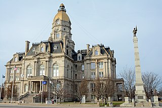
Vigo County, Indiana County in the United States

Vigo County is a county located along the western border of the U.S. state of Indiana. According to the 2010 census, the population was 107,848. The county seat is Terre Haute.

Indiana State of the United States of America

Indiana is a U.S. state located in the Midwestern and Great Lakes regions of North America. Indiana is the 38th largest by area and the 17th most populous of the 50 United States. Its capital and largest city is Indianapolis. Indiana was admitted to the United States as the 19th U.S. state on December 11, 1816. Indiana borders Lake Michigan to the northwest, Michigan to the north, Ohio to the east, Kentucky to the south and southeast, and Illinois to the west.

Contents

Geography

According to the 2010 census, the township has a total area of 18.51 square miles (47.9 km2), of which 17.83 square miles (46.2 km2) (or 96.33%) is land and 0.68 square miles (1.8 km2) (or 3.67%) is water. [1]

Cities, towns, villages

Unincorporated communities

Adjacent townships

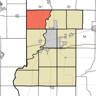
Sugar Creek Township, Vigo County, Indiana Township in Indiana, United States

Sugar Creek Township is one of twelve townships in Vigo County, Indiana, United States. As of the 2010 census, its population was 7,153 and it contained 3,009 housing units.

Honey Creek Township, Vigo County, Indiana Township in Indiana, United States

Honey Creek Township is one of twelve townships in Vigo County, Indiana, United States. As of the 2010 census, its population was 17,179 and it contained 6,509 housing units. It contains Terre Haute's main shopping district along U.S. Route 41 and is by far the most characteristically suburban of the twelve Vigo County townships. The population includes inmates from the Terre Haute Federal Penitentiary, located at its northwest corner.

Linton Township, Vigo County, Indiana Township in Indiana, United States

Linton Township is one of twelve townships in Vigo County, Indiana, United States. As of the 2010 census, its population was 1,323 and it contained 555 housing units.

Cemeteries

The township contains New Harmony Cemetery.

Airports and landing strips

Landmarks

Federal Bureau of Prisons Corrections agency of the US federal government

The Federal Bureau of Prisons (BOP) is a United States enforcement agency responsible for the custody, control, and care of individuals incarcerated in the federal prison system of the United States. Staff are credentialed federal law enforcement officers under the Department of Justice with limited arrest powers within their prison properties.

School districts

Political districts

Indianas 8th congressional district District that is based in southwest and west central Indiana, and includes Evansville, Jasper, Princeton, Terre Haute, Vincennes and Washington

Indiana's 8th congressional district is a congressional district in the U.S. state of Indiana. Based in southwest and west central Indiana, the district is anchored in Evansville and also includes Jasper, Princeton, Terre Haute, Vincennes and Washington.

Municipal

Related Research Articles

North Terre Haute, Indiana Census-designated place in Indiana, United States

North Terre Haute is a census-designated place (CDP) in Otter Creek Township, Vigo County, in the U.S. state of Indiana. The population was 4,305 at the 2010 census. It is part of the Terre Haute Metropolitan Statistical Area.

West Terre Haute, Indiana Town in Indiana, United States

West Terre Haute is a town in Sugar Creek Township, Vigo County, Indiana, on the western side of the Wabash River near Terre Haute. The population was 2,236 at the 2010 census. It is part of the Terre Haute Metropolitan Statistical Area. Bethany Congregational Church was placed on the National Register of Historic Places in 2003.

Prairieton, Indiana Unincorporated community in Indiana, United States

Prairieton is an unincorporated community in Prairieton Township, Vigo County, in the U.S. state of Indiana. Today, due to its proximity to both Terre Haute's southern shopping district and the Terre Haute Federal Penitentiary, it has mostly become a commuter town, with fewer than ten businesses within its "city limits".

Harrison Township, Vigo County, Indiana Township in Indiana, United States

Harrison Township is one of twelve townships in Vigo County, Indiana, United States. As of the 2010 census, its population was 51,272 and it contained 22,940 housing units. It is entirely contained in Terre Haute's city limits, thus explaining why it is both the most densely populated and the most populated overall.

Lost Creek Township, Vigo County, Indiana Township in Indiana, United States

Lost Creek Township is one of twelve townships in Vigo County, Indiana, United States. As of the 2010 census, its population was 10,497 and it contained 4,236 housing units. It contains Terre Haute, Indiana's eastern, suburban end, along with the affluent Hulman family ranch and the Terre Haute International Airport originally named after the family. Seelyville, the third largest city in the county, is also located there.

Pike Township, Warren County, Indiana Township in Indiana, United States

Pike Township is one of twelve townships in Warren County, Indiana, United States. According to the 2010 census, its population was 1,221 and it contained 529 housing units.

Libertyville Township, Lake County, Illinois Township in Illinois, United States

Libertyville Township is a township in Lake County, Illinois, USA. As of the 2010 census, its population was 53,139. The village of Libertyville is part of the township, as are parts of Green Oaks, Lake Bluff, Lake Forest, Mettawa, Mundelein, North Chicago, Rondout, Vernon Hills and Waukegan.

Terre Haute Township, Henderson County, Illinois Township in Illinois, United States

Terre Haute Township is one of eleven townships in Henderson County, Illinois, USA. As of the 2010 census, its population was 263 and it contained 122 housing units.

Prairieton Township, Christian County, Illinois Township in Illinois, United States

Prairieton Township is one of seventeen townships in Christian County, Illinois, USA. As of the 2010 census, its population was 449 and it contained 176 housing units.

Otter Creek Township, Vigo County, Indiana Township in Indiana, United States

Otter Creek Township is one of twelve townships in Vigo County, Indiana, United States. As of the 2010 census, its population was 9,069 and it contained 3,917 housing units.

Fayette Township, Vigo County, Indiana Township in Indiana, United States

Fayette Township is one of twelve townships in Vigo County, Indiana, United States. As of the 2010 census, its population was 2,630 and it contained 1,099 housing units.

Prairie Creek Township, Vigo County, Indiana Township in Indiana, United States

Prairie Creek Township is one of twelve townships in Vigo County, Indiana, United States. As of the 2010 census, its population was 1,195 and it contained 494 housing units.

Riley Township, Vigo County, Indiana Township in Indiana, United States

Riley Township is one of twelve townships in Vigo County, Indiana, United States. As of the 2010 census, its population was 3,123 and it contained 1,260 housing units.

Posey Township, Clay County, Indiana Township in Indiana, United States

Posey Township is one of eleven townships in Clay County, Indiana. As of the 2010 census, its population was 4,063 and it contained 1,706 housing units.

Curry Township, Sullivan County, Indiana Township in Indiana, United States

Curry Township is one of nine townships in Sullivan County, Indiana, United States. As of the 2010 census, its population was 3,559 and it contained 1,643 housing units.

Fairbanks Township, Sullivan County, Indiana Township in Indiana, United States

Fairbanks Township is one of nine townships in Sullivan County, Indiana, United States. As of the 2010 census, its population was 733 and it contained 344 housing units.

References

  1. 1 2 "Population, Housing Units, Area, and Density: 2010 - County -- County Subdivision and Place -- 2010 Census Summary File 1". United States Census. Retrieved 2013-05-10.