Hillsdale is an unincorporated community in Helt Township, Vermillion County, in the U.S. state of Indiana.

Jackson Hill is an unincorporated community in Hamilton Township, Sullivan County, in the U.S. state of Indiana.
Kellerville is an unincorporated community in Harbison Township, Dubois County, in the U.S. state of Indiana.

Whitcomb Heights is an unincorporated community in Sugar Creek Township, Vigo County, in the U.S. state of Indiana. It is officially part of West Terre Haute, Indiana. Whitcomb Heights is part of the Terre Haute metropolitan area.

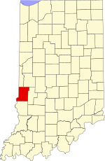
Hickory Island is an unincorporated community in Vigo and Clay counties, in the U.S. state of Indiana.
Larimer Hill is an unincorporated community in Sugar Creek Township, Vigo County, in the U.S. state of Indiana.
Pine Ridge is an unincorporated community in Fayette Township, Vigo County, in the U.S. state of Indiana. It is part of the Terre Haute metropolitan area.
Spring Hill is an unincorporated community in Honey Creek Township, Vigo County, in the U.S. state of Indiana.

Taylorville, also known as Taylorsville or Dresser, is an unincorporated community in eastern Sugar Creek Township, Vigo County, in the U.S. state of Indiana. It is part of the Terre Haute metropolitan area. Though the United States Board on Geographic Names has officially designated the area as Taylorville, the 2010 United States Census considered the area a census designated place called Dresser.

Snow Hill is an unincorporated community in Raccoon Township, Parke County, in the U.S. state of Indiana.

Cunot is an unincorporated community in Jackson Township, Owen County, in the U.S. state of Indiana. It lies near the intersection of Indiana Highway 42 and Indiana Highway 243, which is a community about twenty miles north of the city of Spencer, the county seat of Owen County. Its elevation is 722 feet, and it is located at 39°27′23″N86°51′17″W. Although this community is located within Owen County on its northern boundary, it has an address of Cloverdale, Indiana in Putnam County, which is about six miles northeast of the community.
Denmark is an unincorporated community in the southwest portion of Marion Township, Owen County, in the U.S. state of Indiana. It lies near the intersection of County Road 1400 West and County Road 150 South, which is a community about fifteen miles west of the city of Spencer, the county seat of Owen County. Its elevation is 722 feet, and it is located at 39°16′11″N87°1′33″W.
Farmers is an unincorporated community in the southwest corner of Franklin Township, Owen County, in the U.S. state of Indiana. It lies just south of US Highway 231 at the intersection of 650 West, which is a community about twelve miles south of the city of Spencer, the county seat of Owen County. Its elevation is 591 feet, and it is located at 39°10′31″N86°53′30″W. This community is also known as Farmers Station.
Hubbell is an unincorporated community in the southwestern corner of Jefferson Township, Owen County, in the U.S. state of Indiana. It lies near the intersection of County Road 750 South and Indiana Highway 157, which is a community nearly twenty miles southwest of the city of Spencer, the county seat. Its elevation is 528 feet, and it is located at 39°10′59″N87°0′44″W. This community is also known as Hubbells Station.
Smithville is an unincorporated community in the northwest corner of Marion Township, Owen County, in the U.S. state of Indiana. It lies near the intersection of County Road 200 North and County Road 1400 West, which is a community about fifteen miles west of the city of Spencer, the county seat. Its elevation is 591 feet, and it is located at 39°19′15″N87°1′33″W.
Hickory Corner is an unincorporated community in the northwest corner of Marion Township, Owen County, in the U.S. state of Indiana. It lies near the intersection of County Road 1500 West and Orman Road, which is a community about twenty miles west of the city of Spencer, the county seat. Its elevation is 643 feet, and it is located at 39°18′18″N87°2′40″W.

Crompton Hill is an unincorporated community in Clinton Township, Vermillion County, in the U.S. state of Indiana.
Keytsville is an unincorporated community in Parke and Putnam counties, in the U.S. state of Indiana.
Wayne Center is an unincorporated community in Wayne Township, Noble County, in the U.S. state of Indiana.

Gravel Hill is an unincorporated community in Center Township, Benton County, in the U.S. state of Indiana.