Clay Township is one of thirteen townships in Owen County, Indiana, United States. As of the 2010 census, its population was 2,600 and it contained 1,083 housing units.

Franklin Township is one of thirteen townships in Owen County, Indiana, United States. As of the 2010 census, its population was 1,269 and it contained 551 housing units.

Harrison Township is one of thirteen townships in Owen County, Indiana, United States. As of the 2010 census, its population was 444 and it contained 208 housing units.

Montgomery Township is one of thirteen townships in Owen County, Indiana, United States. As of the 2010 census, its population was 1,304 and it contained 569 housing units.

Morgan Township is one of thirteen townships in Owen County, Indiana, United States. As of the 2010 census, its population was 1,237 and it contained 668 housing units.

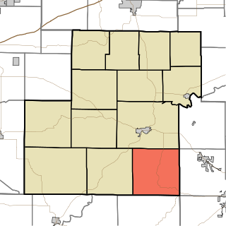
Washington Township is one of thirteen townships in Owen County, Indiana, United States. As of the 2010 census, its population was 6,164 and it contained 2,755 housing units.

Patricksburg is an unincorporated community in eastern Marion Township, Owen County, in the U.S. state of Indiana. It lies along State Road 246, west of the city of Spencer, the county seat of Owen County. Its elevation is 715 feet (218 m), and it is located at 39°18′56″N86°57′33″W. Although Patricksburg is unincorporated, it has a post office, with the ZIP code of 47455.
Vandalia is an unincorporated community in Lafayette Township, Owen County, in the U.S. state of Indiana.
Jordan is an unincorporated community in Morgan Township, Owen County, in the U.S. state of Indiana.

Cataract is an unincorporated community in Jennings Township, Owen County, in the U.S. state of Indiana.

Pottersville is an unincorporated community in Franklin Township, Owen County, in the U.S. state of Indiana.
Atkinsonville is an unincorporated community in Morgan Township, Owen County, in the U.S. state of Indiana.
Adel is an unincorporated community in eastern Franklin Township, Owen County, in the U.S. state of Indiana. It lies near the bridge on County Road 150 West over Raccoon Creek, which is a community nearly ten miles southwest of the city of Spencer, the county seat. Its elevation is 541 feet (165 m), and it is located at 39°11′31″N86°47′45″W.
Carp is an unincorporated community in the northeastern part of Montgomery Township, Owen County, in the U.S. state of Indiana. It lies near the intersection of US Highway 231 and County Road 50 East, which is a community nearly eight miles north of the city of Spencer, the county seat of Owen County. Its elevation is 722 feet, and it is located at 39°23′6″N86°45′39″W.
Cuba is an unincorporated community in the northwestern part of Montgomery Township, Owen County, in the U.S. state of Indiana. It lies near the intersection of County Road 150 West and County Road 600 North, which is a community about ten miles north of the town of Spencer, the county seat of Owen County. Its elevation is 722 feet, and it is located at 39°22′41″N86°47′53″W.

Cunot is an unincorporated community in Jackson Township, Owen County, in the U.S. state of Indiana. It lies near the intersection of Indiana Highway 42 and Indiana Highway 243, which is a community about twenty miles north of the city of Spencer, the county seat of Owen County. Its elevation is 722 feet, and it is located at 39°27′23″N86°51′17″W. Although this community is located within Owen County on its northern boundary, it has an address of Cloverdale, Indiana in Putnam County, which is about six miles northeast of the community.
Denmark is an unincorporated community in the southwest portion of Marion Township, Owen County, in the U.S. state of Indiana. It lies near the intersection of County Road 1400 West and County Road 150 South, which is a community about fifteen miles west of the city of Spencer, the county seat of Owen County. Its elevation is 722 feet, and it is located at 39°16′11″N87°1′33″W.
Freeman is an unincorporated community in the center of Clay Township, Owen County, in the U.S. state of Indiana. It lies near the intersection of County Road 650 South and Indiana Highway 43, which is a community nearly nine miles south of the city of Spencer, the county seat. Its elevation is 541 feet (165 m), and it is located at 39°11′44″N86°44′1″W.
Braysville is an unincorporated community in the western part of Clay Township, Owen County, in the U.S. state of Indiana. It lies near the intersection of Freedom Road and Ranard Road, which is a community about six miles south of the city of Spencer, the county seat. Its elevation is 735 feet, and it is located at 39°12′42″N86°46′28″W.
Lewisville is an unincorporated community in the northeast corner of Harrison Township, Owen County, in the U.S. state of Indiana. It lies near the intersection of County Road 700 East and West Lewisville Road, which is a community about twenty miles northeast of the city of Spencer, the county seat. Its elevation is 771 feet, and it is located at 39°28′16″N86°37′55″W. This community lies on the border of Owen County and Morgan County.


