
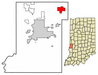
Terre Haute is a city in and the county seat of Vigo County, Indiana, United States, about 5 miles east of the state's western border with Illinois. As of the 2020 census, the city had a population of 58,389 and its metropolitan area had a population of 168,716.

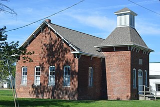
West Terre Haute is a town in Sugar Creek Township, Vigo County, Indiana, on the western side of the Wabash River near Terre Haute. The population was 2,236 at the 2010 census. It is part of the Terre Haute Metropolitan Statistical Area. Bethany Congregational Church was placed on the National Register of Historic Places in 2003.

Prairieton is an unincorporated community in Prairieton Township, Vigo County, in the U.S. state of Indiana. Today, due to its proximity to both Terre Haute's southern shopping district and the Terre Haute Federal Penitentiary, it has mostly become a commuter town, with fewer than ten businesses within its "city limits".
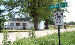
Johnsonville is a small unincorporated community in Steuben Township, Warren County, in the U.S. state of Indiana.
Lewis, also known as Lewisburg or Centerville, is an unincorporated community in Vigo County, in the U.S. state of Indiana. Originally platted entirely within Vigo County, it has now expanded into adjacent Sullivan County.
New Goshen is a census-designated place (CDP) in Fayette Township, Vigo County, in the U.S. state of Indiana. It is part of the Terre Haute Metropolitan Statistical Area.
Billtown is an unincorporated community in Posey Township, Clay County, Indiana. It is part of the Terre Haute Metropolitan Statistical Area.
Cardonia is an unincorporated community in Van Buren Township, Clay County, Indiana. It is part of the Terre Haute Metropolitan Statistical Area.

Cloverland is an unincorporated community in Posey Township, Clay County, Indiana. It is part of the Terre Haute Metropolitan Statistical Area.

Shepardsville is an unincorporated census-designated place in northeastern Fayette Township, Vigo County, in the U.S. state of Indiana. It lies along Trinity Ave. north of the city of Terre Haute, the county seat of Vigo County. Its elevation is 502 feet (153 m), and it is located at 39°36′3″N87°25′3″W. Although Shepardsville is unincorporated, it has a post office, with the ZIP code of 47880.
Fontanet is an unincorporated census-designated place in central Nevins Township, Vigo County, in the U.S. state of Indiana. It lies along Baldwin St., northeast of the city of Terre Haute, the county seat of Vigo County. Its elevation is 614 feet (187 m), and it is located at 39°34′34″N87°14′37″W. Although Fontanet is unincorporated, it has a post office, with the ZIP Code of 47851.

Atherton is an unincorporated community in northern Otter Creek Township, Vigo County, in the U.S. state of Indiana. It is part of the Terre Haute metropolitan area.
Cherryvale is an unincorporated community in Vigo and Clay counties, in the U.S. state of Indiana.
Coal Bluff is an unincorporated community in northern Nevins Township, Vigo County, in the U.S. state of Indiana.

Taylorville, also known as Taylorsville or Dresser, is an unincorporated community in eastern Sugar Creek Township, Vigo County, in the U.S. state of Indiana. It is part of the Terre Haute metropolitan area. Though the United States Board on Geographic Names has officially designated the area as Taylorville, the 2010 United States Census considered the area a census designated place called Dresser.

Curryville is an unincorporated community in Curry Township, Sullivan County, in the U.S. state of Indiana.

The Vandalia Railroad Company was incorporated January 1, 1905, by a merger of several lines in Indiana and Illinois that formed a 471-mile railroad consisting of lines mostly west of Indianapolis.
Bolivar is an unincorporated community in Chester Township, Wabash County, in the U.S. state of Indiana.
Parker City, also known simply as Parker, is a former settlement in Johnson County, Illinois, United States. Parker City was west of New Burnside, south of Creal Springs, and founded at the crossings of the former Cleveland, Cincinnati, Chicago and St. Louis Railway and Marion to Brookport branch of the Illinois Central Railroad. The town was named after George Washington Parker, a former president of the St. Louis, Alton and Terre Haute Railroad, which was a predecessor to the Big Four.
Terre Haute is an extinct town in Putnam County, in the U.S. state of Missouri. The GNIS classifies it as a populated place.


