Bloomingdale, Indiana

Last updated

Bloomingdale, Indiana
Jungle Park Cabins and Cafe, Bloomingdale, Ind., 8 miles north of Rockville on U. S. 41 (82791).jpg
Parke County Indiana Incorporated and Unincorporated areas Bloomingdale Highlighted 1805788.svg
Location of Bloomingdale in Parke County, Indiana.
Locator map of Parke County, Indiana.svg
Red pog.svg
Bloomingdale
Location in Parke County
Coordinates: 39°49′50″N87°14′57″W / 39.83056°N 87.24917°W / 39.83056; -87.24917
Country Flag of the United States (23px).png  United States
State Flag of Indiana.svg  Indiana
County Parke
Township Penn
Area
[1]
  Total0.58 sq mi (1.51 km2)
  Land0.58 sq mi (1.51 km2)
  Water0.00 sq mi (0.00 km2)
Elevation
[2]
646 ft (197 m)
Population
 (2020)
  Total269
  Density462.20/sq mi (178.59/km2)
Time zone UTC-5 (Eastern (EST))
  Summer (DST) UTC-5 (EST)
ZIP code
47832
Area code 765
FIPS code 18-05788
GNIS ID2396593 [2]

Bloomingdale is a town in Penn Township, Parke County, in the U.S. state of Indiana. [2] The population was 335 at the 2010 census.

Contents

History

The town of Bloomingdale was platted in 1825 or 1826, south of its present location. Originally it was named Bloomfield. [3] A post office called Bloomingdale has been in operation since 1860. [4] The Friends' Bloomingdale Academy was in operation from 1846 to 1916.

The William Hill Polygonal Barn was listed on the National Register of Historic Places in 1993. [5]

On June 17, 2021, a magnitude 3.8 earthquake occurred 2 miles west of Bloomingdale. No damage was reported.

Geography

Bloomingdale is located about 6 miles (9.7 km) north of the county seat of Rockville. U.S. Route 41 passes less than a mile to the east of the town. [6]

According to the 2010 census, Bloomingdale has a total area of 0.58 square miles (1.50 km2), all land. [7]

Demographics

Historical population
CensusPop.Note
1880 355
1890 43121.4%
1900 50517.2%
1910 5284.6%
1920 479−9.3%
1930 412−14.0%
1940 4324.9%
1950 4340.5%
1960 4554.8%
1970 391−14.1%
1980 4094.6%
1990 341−16.6%
2000 319−6.5%
2010 3355.0%
2020 269−19.7%
U.S. Decennial Census [8]

2010 census

As of the 2010 census, [9] there were 335 people, 129 households, and 96 families living in the town. The population density was 577.6 inhabitants per square mile (223.0/km2). There were 150 housing units at an average density of 258.6 per square mile (99.8/km2). The racial makeup of the town was 97.6% White, 0.3% African American, and 2.1% from two or more races. Hispanic or Latino of any race were 0.3% of the population.

There were 129 households, of which 35.7% had children under the age of 18 living with them, 55.8% were married couples living together, 14.0% had a female householder with no husband present, 4.7% had a male householder with no wife present, and 25.6% were non-families. 20.9% of all households were made up of individuals, and 11.6% had someone living alone who was 65 years of age or older. The average household size was 2.60 and the average family size was 3.02.

The median age in the town was 38.5 years. 23.6% of residents were under the age of 18; 10.9% were between the ages of 18 and 24; 22.8% were from 25 to 44; 30.2% were from 45 to 64; and 12.8% were 65 years of age or older. The gender makeup of the town was 50.4% male and 49.6% female.

2000 census

As of the 2000 census, [10] there were 319 people, 135 households, and 88 families living in the town. The population density was 558.7 inhabitants per square mile (215.7/km2). There were 159 housing units at an average density of 278.5 per square mile (107.5/km2). The racial makeup of the town was 99.06% White, 0.31% African American, 0.31% Pacific Islander, and 0.31% from two or more races.

There were 135 households, out of which 27.4% had children under the age of 18 living with them, 54.1% were married couples living together, 8.1% had a female householder with no husband present, and 34.8% were non-families. 31.1% of all households were made up of individuals, and 16.3% had someone living alone who was 65 years of age or older. The average household size was 2.36 and the average family size was 2.99.

In the town, the population was spread out, with 25.4% under the age of 18, 6.9% from 18 to 24, 29.5% from 25 to 44, 24.1% from 45 to 64, and 14.1% who were 65 years of age or older. The median age was 38 years. For every 100 females, there were 84.4 males. For every 100 females age 18 and over, there were 85.9 males.

The median income for a household in the town was $36,500, and the median income for a family was $46,071. Males had a median income of $27,308 versus $20,417 for females. The per capita income for the town was $17,928. About 2.2% of families and 2.0% of the population were below the poverty line, including none of those under age 18 and 4.9% of those age 65 or over.

Related Research Articles

<span class="mw-page-title-main">Onward, Indiana</span> Town in Indiana, United States

Onward is a town in Tipton Township, Cass County, Indiana, United States. The population was 100 at the 2010 census.

<span class="mw-page-title-main">Milltown, Indiana</span> Town in Indiana, United States

Milltown is a town in Whiskey Run Township in Crawford County, Indiana and in Blue River and Spencer townships in Harrison County. The population was 818 at the time of the 2010 census.

<span class="mw-page-title-main">Shirley, Indiana</span> Town in Indiana, United States

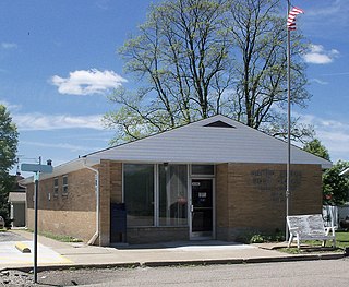
Shirley is a town in Brown Township, Hancock County and Greensboro Township, Henry County, Indiana, United States. The population was 830 at the 2010 census.

<span class="mw-page-title-main">Bargersville, Indiana</span> Town in Indiana, United States

Bargersville is a town in White River and Union townships, Johnson County, Indiana, United States. The population was 9,560 at the 2020 census.

<span class="mw-page-title-main">Silver Lake, Indiana</span> Town in Indiana, United States

Silver Lake is a town in Lake Township, Kosciusko County, in the U.S. state of Indiana. The population was 915 at the 2010 census.

<span class="mw-page-title-main">Syracuse, Indiana</span> Town in Indiana, United States

Syracuse is a town in Turkey Creek Township, Kosciusko County, in the U.S. state of Indiana. The population was 3,079 at the 2020 census. Syracuse is the location of Lake Syracuse and the nearby, larger Lake Wawasee, in addition to several other lakes in the region. The National Weather Service operates a Weather Forecast Office South of town, toward North Webster. It serves Northern Indiana.

<span class="mw-page-title-main">Kingsbury, Indiana</span> Town in Indiana, United States

Kingsbury is a town in Washington Township, LaPorte County, Indiana, just northwest of the intersection of U.S. Route 35 and U.S. Route 6. The town was founded in 1835 and incorporated on March 3, 1941. During 1940 - 1941, the Kingsbury Ordnance Plant (KOP) was built for use during World War II. The plant closed after the war but reopened during the Korean War, closing permanently in 1959. The population was 242 at the 2010 census. It is included in the Michigan City, Indiana-La Porte, Indiana Metropolitan Statistical Area. The town has its own fire department, KVFD, and a Greek revival style First Baptist church built in 1851 with its own graveyard and Winchell Cemetery.

<span class="mw-page-title-main">Ingalls, Indiana</span> Town in Indiana, United States

Ingalls is a town in Green Township, Madison County, Indiana, United States. It is part of the Indianapolis–Carmel–Anderson metropolitan statistical area. The population was 2,223 at the 2020 census.

<span class="mw-page-title-main">Marshall, Indiana</span> Town in Indiana, United States

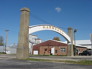
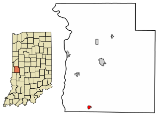
Marshall is a town in Washington Township, Parke County, Indiana, United States. As of the 2010 census, the population was 324.

<span class="mw-page-title-main">Mecca, Indiana</span> Town in Indiana, United States

Mecca is a town in Wabash Township, Parke County, in the U.S. state of Indiana. The population was 335 at the 2010 census.

<span class="mw-page-title-main">Montezuma, Indiana</span> Town in Indiana, United States

Montezuma is a town in Reserve Township, Parke County, in the U.S. state of Indiana. The population was 1,022 at the 2010 census. It is located approximately 66 miles west of the state capital Indianapolis.

<span class="mw-page-title-main">Rockville, Indiana</span> Town in Indiana, United States

Rockville is a town in Adams Township, Parke County, in the U.S. state of Indiana. The population was 2,607 at the 2010 census. The town is the county seat of Parke County. It is known as "The Covered Bridge Capital of the World".

<span class="mw-page-title-main">Rosedale, Indiana</span> Town in Indiana, United States

Rosedale is a town in Florida Township, Parke County, in the U.S. state of Indiana. The population was 725 at the 2010 census.

<span class="mw-page-title-main">Bainbridge, Indiana</span> Town in Indiana, United States

Bainbridge is a town in Monroe Township, Putnam County, in the U.S. state of Indiana. The population was 746 at the 2010 census.

<span class="mw-page-title-main">Cayuga, Indiana</span> Town in Indiana, United States

Cayuga is a town in Eugene Township, Vermillion County, in the U.S. state of Indiana. The population was 1,162 at the 2010 census.

<span class="mw-page-title-main">Fairview Park, Indiana</span> Town in Indiana, United States

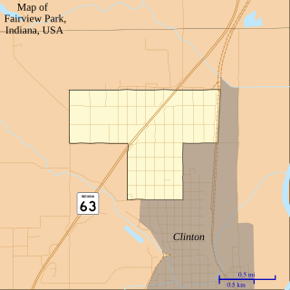
Fairview Park is a town in Clinton Township, Vermillion County, in the U.S. state of Indiana. The population was 1,386 at the 2010 census.

<span class="mw-page-title-main">Mount Auburn, Indiana</span> Town in Indiana, United States

Mount Auburn is a town in Jackson Township, Wayne County, in the U.S. state of Indiana. The population was 117 at the 2010 census. The town is sandwiched between Dublin and Cambridge City.

<span class="mw-page-title-main">Bloomingdale Township, Michigan</span> Township in Michigan, United States

Bloomingdale Township is a civil township of Van Buren County in the U.S. state of Michigan. As of the 2020 census, the township population was 2,930. It was established in 1845.

<span class="mw-page-title-main">Bloomingdale, Michigan</span> Village in Michigan, United States

Bloomingdale is a village in Van Buren County in the U.S. state of Michigan. The population was 454 at the 2010 census. The village is located within Bloomingdale Township and is the township seat.

<span class="mw-page-title-main">Bloomingdale, Ohio</span> Village in Ohio, United States

Bloomingdale is a village in central Jefferson County, Ohio, United States. The population was 145 at the 2020 census. It is part of the Weirton–Steubenville metropolitan area.

References

  1. "2020 U.S. Gazetteer Files". United States Census Bureau. Retrieved March 16, 2022.
  2. 1 2 3 U.S. Geological Survey Geographic Names Information System: Bloomingdale, Indiana
  3. Bowen 1913, p. 196.
  4. "Parke County". Jim Forte Postal History. Retrieved September 30, 2015.
  5. "National Register Information System". National Register of Historic Places . National Park Service. July 9, 2010.
  6. Google (January 14, 2012). "Bloomingdale, Indiana" (Map). Google Maps . Google. Retrieved January 14, 2012.
  7. "G001 - Geographic Identifiers - 2010 Census Summary File 1". United States Census Bureau. Archived from the original on February 13, 2020. Retrieved July 13, 2015.
  8. "Census of Population and Housing". Census.gov. Retrieved June 4, 2015.
  9. "U.S. Census website". United States Census Bureau . Retrieved December 11, 2012.
  10. "U.S. Census website". United States Census Bureau . Retrieved January 31, 2008.

Bibliography