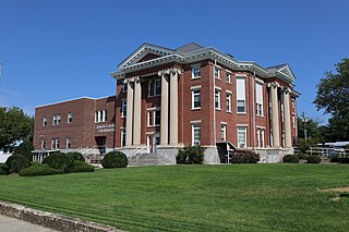
Hardy County is a county in the U.S. state of West Virginia. As of the 2020 census, the population was 14,299. Its county seat is Moorefield. The county was created from Hampshire County in 1786 and named for Samuel Hardy, a distinguished Virginian.
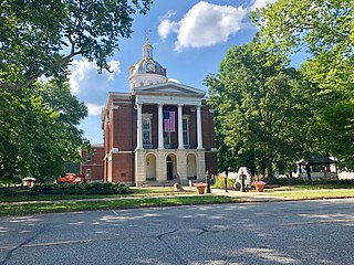
Switzerland County is a county in the southeast corner of the U.S. state of Indiana. As of the 2020 United States Census, the population was 9,737. The county seat is Vevay, one of two incorporated towns in the county.

Moorefield is a town and the county seat of Hardy County, West Virginia, United States. It is located at the confluence of the South Branch Potomac River and the South Fork South Branch Potomac River. Moorefield was originally chartered in 1777; it was named for Conrad Moore, who owned the land upon which the town was laid out. The population was 2,527 at the 2020 census.

The South Branch Potomac River has its headwaters in northwestern Highland County, Virginia, near Hightown along the eastern edge of the Allegheny Front. After a river distance of 139 miles (224 km), the mouth lies east of Green Spring, Hampshire County, West Virginia, where it meets the North Branch Potomac River to form the Potomac.

Moorefield Township is one of the ten townships of Clark County, Ohio, United States. The population as of the 2020 census was 12,622.

Francis Marion Griffith was an American educator and politician who served four terms as a U.S. Representative from Indiana from 1897 to 1905.
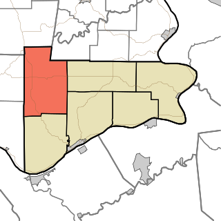
Pleasant Township is one of six townships in Switzerland County, Indiana, United States. As of the 2010 census, its population was 1,521 and it contained 610 housing units.
North Grove is an unincorporated community and census-designated place (CDP) in Harrison Township, Miami County, in the U.S. state of Indiana.
Moorefield and North Branch Turnpike was a turnpike in the U.S. state of Virginia built to facilitate travel and commerce between the Baltimore and Ohio Railroad at Green Spring on the North Branch Potomac River and Moorefield. Today, Green Spring Road, Harriott-Wappocomo Road, and West Virginia Route 28 encompass most of the Moorefield and North Branch Turnpike's original route.

Moorefield is a census-designated place (CDP) in Loudoun County, Virginia, United States. As of the 2010 census, the CDP was named Moorefield Station, and the population was 77. As of 2019, the estimated population was 1,976. Moorefield is a mixed-use development currently in progress, located at the Ashburn station at the western terminus of the Metrorail Silver Line.
Moorefield is an unincorporated community in Harrison County, in the U.S. state of Ohio.
New Moorefield is an unincorporated community in Clark County, in the U.S. state of Ohio.
Markland is an unincorporated community in York Township, Switzerland County, in the U.S. state of Indiana.
Lamb is an unincorporated community in Craig Township, Switzerland County, in the U.S. state of Indiana.
Jacksonville is an unincorporated community in Jefferson Township, Switzerland County, in the U.S. state of Indiana.
Braytown is an unincorporated community in Craig Township, Switzerland County, in the U.S. state of Indiana.
Quercus Grove is an unincorporated community in Posey Township, Switzerland County, in the U.S. state of Indiana.
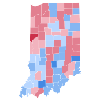
The 1916 United States presidential election in Indiana took place on November 7, 1916, as part of the 1916 United States presidential election which was held throughout all contemporary 48 states. Voters chose 15 representatives, or electors to the Electoral College, who voted for president and vice president.


