Tennyson, Indiana

Last updated

Tennyson, Indiana
Tennyson-Main-in.jpg
Main Street (SR 161)
Warrick County Indiana Incorporated and Unincorporated areas Tennyson Highlighted 1875302.svg
Location of Tennyson in Warrick County, Indiana.
Coordinates: 38°4′54″N87°7′8″W / 38.08167°N 87.11889°W / 38.08167; -87.11889
Country United States
State Indiana
County Warrick
Township Skelton
Area
[1]
  Total0.23 sq mi (0.61 km2)
  Land0.23 sq mi (0.61 km2)
  Water0.00 sq mi (0.00 km2)
Elevation
[2]
404 ft (123 m)
Population
 (2020)
  Total213
  Density910.26/sq mi (351.72/km2)
Time zone UTC-6 (Central (CST))
  Summer (DST) UTC-5 (CDT)
ZIP code
47637
Area code 812
FIPS code 18-75302 [3]
GNIS feature ID2397694 [2]
Website https://townoftennyson.com/

Tennyson is a town in Skelton Township, Warrick County, in the U.S. state of Indiana. [2] The population was 279 at the 2010 census.

Contents

History

A post office has been in operation at Tennyson since 1881. [4] A town plat was made in about 1882. [5] The town was named after George Martin Van Buren Tennyson .

Geography

Tennyson is located at 38°4′54″N87°7′8″W / 38.08167°N 87.11889°W / 38.08167; -87.11889 (38.081673, -87.118946). [6] The town lies in eastern Warrick County, northeast of Boonville, the county seat. Indiana State Road 161 (signed as Main Street) traverses the town from north to south. Little Pigeon Creek and its associated state wetland conservation area lies just east of Tennyson.

According to the 2010 census, Tennyson has a total area of 0.23 square miles (0.60 km2), all land. [7]

Demographics

Historical population
CensusPop.Note
1900 302
1910 37122.8%
1920 3864.0%
1930 335−13.2%
1940 293−12.5%
1950 40939.6%
1960 312−23.7%
1970 3357.4%
1980 331−1.2%
1990 267−19.3%
2000 2908.6%
2010 279−3.8%
2020 213−23.7%
U.S. Decennial Census [8]

2010 census

As of the census [9] of 2010, there were 279 people, 106 households, and 75 families living in the town. The population density was 1,213.0 inhabitants per square mile (468.3/km2). There were 111 housing units at an average density of 482.6 per square mile (186.3/km2). The racial makeup of the town was 99.3% White, 0.4% African American, and 0.4% from other races. Hispanic or Latino of any race were 2.2% of the population.

There were 106 households, of which 36.8% had children under the age of 18 living with them, 47.2% were married couples living together, 16.0% had a female householder with no husband present, 7.5% had a male householder with no wife present, and 29.2% were non-families. 20.8% of all households were made up of individuals, and 7.6% had someone living alone who was 65 years of age or older. The average household size was 2.63 and the average family size was 2.89.

The median age in the town was 40.1 years. 24.4% of residents were under the age of 18; 8.2% were between the ages of 18 and 24; 22.9% were from 25 to 44; 31.5% were from 45 to 64; and 12.9% were 65 years of age or older. The gender makeup of the town was 50.5% male and 49.5% female.

2000 census

As of the census [3] of 2000, there were 290 people, 105 households, and 82 families living in the town. The population density was 1,155.1 inhabitants per square mile (446.0/km2). There were 111 housing units at an average density of 442.1 per square mile (170.7/km2). The racial makeup of the town was 98.97% White, 0.34% African American, and 0.69% from two or more races. Hispanic or Latino of any race were 0.34% of the population.

There were 105 households, out of which 43.8% had children under the age of 18 living with them, 52.4% were married couples living together, 15.2% had a female householder with no husband present, and 21.0% were non-families. 17.1% of all households were made up of individuals, and 5.7% had someone living alone who was 65 years of age or older. The average household size was 2.76 and the average family size was 3.08.

In the town, the population was spread out, with 29.7% under the age of 18, 9.3% from 18 to 24, 31.7% from 25 to 44, 19.0% from 45 to 64, and 10.3% who were 65 years of age or older. The median age was 34 years. For every 100 females, there were 92.1 males. For every 100 females age 18 and over, there were 94.3 males.

The median income for a household in the town was $36,250, and the median income for a family was $36,250. Males had a median income of $25,833 versus $20,000 for females. The per capita income for the town was $13,660. About 13.7% of families and 16.8% of the population were below the poverty line, including 20.2% of those under the age of eighteen and 21.7% of those 65 or over.

Education

Tennyson has a public library, a branch of the Boonville-Warrick County Public Library. [10]

Tennyson has an Elementary school. [11]

Related Research Articles

<span class="mw-page-title-main">Warrick County, Indiana</span> County in Indiana, United States

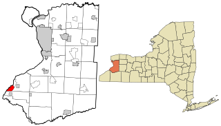
Warrick County is a county located in the U.S. state of Indiana. As of 2020, the population was 63,898. The county seat is Boonville. It was organized in 1813 and was named for Captain Jacob Warrick, an Indiana militia company commander killed in the Battle of Tippecanoe in 1811. It is one of the ten fastest-growing counties in Indiana.

<span class="mw-page-title-main">Crane, Indiana</span> Town in Indiana, United States

Crane is a town in Perry Township, Martin County, in the U.S. state of Indiana. The population was 166 at the 2020 census. The community is adjacent to the Naval Surface Warfare Center Crane Division.

<span class="mw-page-title-main">Denver, Indiana</span> Town in Indiana, United States

Denver is a town in Jefferson Township, Miami County, in the U.S. state of Indiana. The population was 478 at the 2020 census.

<span class="mw-page-title-main">Troy, Indiana</span> Town in Indiana, United States

Troy is a town in Troy Township, Perry County, Indiana, along the Ohio River near the mouth of the Anderson River. It is the second oldest city in Indiana. The population was 347 at the 2020 census.

<span class="mw-page-title-main">Farmland, Indiana</span> Town in Indiana, United States

Farmland is a town in Monroe Township, Randolph County, in the U.S. state of Indiana. The population was 1,333 at the 2010 census.

<span class="mw-page-title-main">Chrisney, Indiana</span> Town in Indiana, United States

Chrisney is a town in Grass Township, Spencer County, in the U.S. state of Indiana. The population was 481 at the 2010 census.

<span class="mw-page-title-main">Dale, Indiana</span> Town in Indiana, United States

Dale is a town in Carter Township, Spencer County, in the U.S. state of Indiana. The population was 1,593 at the 2010 census.

<span class="mw-page-title-main">Gentryville, Indiana</span> Town in Indiana, United States

Gentryville is a town in Jackson Township, Spencer County, in the U.S. state of Indiana. The population was 268 at the 2010 census.

<span class="mw-page-title-main">Grandview, Indiana</span> Town in Indiana, United States

Grandview is a town in Hammond Township, Spencer County, Indiana, along the Ohio River. The population was 749 at the 2010 census.

<span class="mw-page-title-main">Carlisle, Indiana</span> Town in Indiana, United States

Carlisle is a town in Haddon Township, Sullivan County, in the U.S. state of Indiana. The population was 692 at the 2010 census. It is part of the Terre Haute Metropolitan Statistical Area. Carlisle is home to the Wabash Valley Correctional Facility.

<span class="mw-page-title-main">Darmstadt, Indiana</span> Town in Indiana, United States

Darmstadt is a small, German-heritage town primarily located in Scott Township, Vanderburgh County, Indiana, United States. It also extends slightly into Armstrong, Center and German townships. The population was 1,407 at the 2010 census. Darmstadt, located just north of Evansville, is the only other incorporated municipality in Vanderburgh County besides Evansville.

<span class="mw-page-title-main">Boonville, Indiana</span> City in Indiana, United States

Boonville is a city in Boon Township, Warrick County, Indiana, United States. The population was 6,246 at the 2010 census. The city is the county seat of Warrick County.

<span class="mw-page-title-main">Chandler, Indiana</span> Town in Indiana, United States

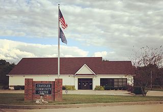
Chandler is a town straddling Ohio and Boon Township in Warrick County, Indiana, United States, located just east of Evansville, Indiana along the Ohio River. The population was 3,693 at the 2020 census, making it Warrick County's second-most populous municipality after Boonville. The town is part of the Evansville metropolitan area with a population of 342,815.

<span class="mw-page-title-main">Elberfeld, Indiana</span> Town in Indiana, United States

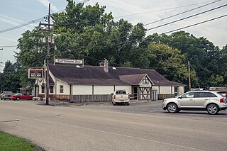
Elberfeld is a town in Greer Township, Warrick County, in the U.S. state of Indiana. The population was 625 as of the 2010 census.

<span class="mw-page-title-main">Lynnville, Indiana</span> Town in Indiana, United States

Lynnville is a town in Hart Township, Warrick County, in the U.S. state of Indiana. The population was 888 at the 2010 census.

<span class="mw-page-title-main">Livonia, Indiana</span> Town in Indiana, United States

Livonia is a town in Madison Township, Washington County, in the U.S. state of Indiana. The population was 128 at the 2010 census.

<span class="mw-page-title-main">Vera Cruz, Indiana</span> Town in Indiana, United States

Vera Cruz is a town in Harrison Township, Wells County, in the U.S. state of Indiana. The population was 80 at the 2010 census.

<span class="mw-page-title-main">Blencoe, Iowa</span> City in Iowa, United States

Blencoe is a city in Monona County, Iowa, United States. The population was 233 at the 2020 census.

<span class="mw-page-title-main">Lake Erie Beach, New York</span> Census-designated place in New York, United States

Lake Erie Beach is a hamlet and census-designated place (CDP) in the town of Evans, Erie County, New York, United States. The population was 3,872 at the 2010 census. It is part of the Buffalo–Niagara Falls Metropolitan Statistical Area.

<span class="mw-page-title-main">Pine Grove, West Virginia</span> Town in West Virginia, United States

Pine Grove is a town in Wetzel County, West Virginia, United States. The population was 363 at the 2020 census. The community was named for a grove of pine trees near the original town site.

References

  1. "2020 U.S. Gazetteer Files". United States Census Bureau. Retrieved March 16, 2022.
  2. 1 2 3 U.S. Geological Survey Geographic Names Information System: Tennyson, Indiana
  3. 1 2 "U.S. Census website". United States Census Bureau . Retrieved January 31, 2008.
  4. "Warrick County". Jim Forte Postal History. Retrieved October 3, 2015.
  5. Baker, Ronald L. (October 1995). From Needmore to Prosperity: Hoosier Place Names in Folklore and History. Indiana University Press. p. 321. ISBN   978-0-253-32866-3. ...town was platted about 1882.
  6. "US Gazetteer files: 2010, 2000, and 1990". United States Census Bureau. February 12, 2011. Retrieved April 23, 2011.
  7. "G001 - Geographic Identifiers - 2010 Census Summary File 1". United States Census Bureau. Archived from the original on February 13, 2020. Retrieved July 25, 2015.
  8. "Census of Population and Housing". Census.gov. Retrieved June 4, 2015.
  9. "U.S. Census website". United States Census Bureau . Retrieved December 11, 2012.
  10. "Boonville-Warrick County Public Library (Tennyson Branch)". librarything. Retrieved March 15, 2018.
  11. "Tennyson Elementary School". tennyson.warrick.k12.in.us. ParentSquare. Retrieved October 20, 2023.