Owensville, Indiana

Last updated

Owensville, Indiana
Town of Owensville
Owensville, Indiana.jpg
Row of buildings along east side of town square. Owensville Town Hall is on far left.
Gibson County Indiana Incorporated and Unincorporated areas Owensville Highlighted 1857528.svg
Location of Owensville in Gibson County, Indiana
Coordinates: 38°16′19″N87°41′30″W / 38.27194°N 87.69167°W / 38.27194; -87.69167
Country United States
State Indiana
County Gibson
Township Montgomery
Area
[1]
  Total0.57 sq mi (1.47 km2)
  Land0.57 sq mi (1.47 km2)
  Water0.00 sq mi (0.00 km2)
Elevation
[2]
525 ft (160 m)
Population
 (2020)
  Total1,338
  Density2,351.49/sq mi (907.92/km2)
Time zone UTC-6 (Central (CST))
  Summer (DST) UTC-5 (CDT)
ZIP code
47665
Area code(s) 812, 930
FIPS code 18-57528 [3]
GNIS feature ID2396843 [2]
Major State Roads Indiana 65.svg Indiana 165.svg Indiana 168.svg
Website http://owensville.org/1.html

Owensville is the third largest town and the smallest of the five larger communities in Gibson County, Indiana, United States. The population was 1,338 in 2020.

Contents

History

Owensville was established in 1817 [4] [5] by Phillip Briscoe, when he filed the town plat consisting of 52 parcels and five out-parcels. A fire in 1876 destroyed many of the wood framed businesses on the eastern side of the town square.

It was not until 1881 that Owensville incorporated. [6]

On March 18, 1925, the Tri-State Tornado struck just northwest of the town, killing nine people.

On February 28, 2017, an EF3 wedge tornado, originating in Crossville, Illinois, passed to the south of the town, destroying or heavily damaging several structures along Indiana 65. The highway was closed for several days as power crews replaced several large power poles. [7]

On April 8, 2024, Owensville, along with most of the rest of southwestern Indiana will view a total solar eclipse, lasting approximately 3 minutes and 55 seconds. [8]

Geography

Owensville is located at 38°16′18″N87°41′26″W / 38.27167°N 87.69056°W / 38.27167; -87.69056 (38.271769, -87.690652). [9]

According to the 2010 census, Owensville has a total area of 0.59 square miles (1.53 km2), all land. [10]

Climate

The climate in this area is characterized by hot, humid summers and generally mild to cool winters. According to the Köppen Climate Classification system, Owensville has a humid subtropical climate, abbreviated "Cfa" on climate maps, [11] although areas just north of town have a humid continental climate. Local meteorologists often tend to use nearby Interstate 64 for comparison of local weather events.

In relation to climate, in 2004, the National Weather Service installed a NEXRAD Doppler Radar station approximately 2 miles west of the town.

Demographics

Historical population
CensusPop.Note
1850 235
1860 491108.9%
1870 5226.3%
1880 68531.2%
1890 75910.8%
1900 1,01934.3%
1910 1,23721.4%
1920 1,2390.2%
1930 1,056−14.8%
1940 1,18812.5%
1950 1,110−6.6%
1960 1,1211.0%
1970 1,056−5.8%
1980 1,26119.4%
1990 1,053−16.5%
2000 1,32225.5%
2010 1,284−2.9%
2020 1,3384.2%
U.S. Decennial Census [12]

2010 census

As of the census [13] of 2010, there were 1,284 people, 510 households, and 337 families living in the town. The population density was 2,176.3 inhabitants per square mile (840.3/km2). There were 567 housing units at an average density of 961.0 per square mile (371.0/km2). The racial makeup of the town was 97.9% White, 0.2% African American, 0.7% Native American, 0.2% Asian, and 0.9% from two or more races. Hispanic or Latino people of any race were 1.2% of the population.

There were 510 households, of which 33.1% had children under the age of 18 living with them, 48.8% were married couples living together, 12.9% had a female householder with no husband present, 4.3% had a male householder with no wife present, and 33.9% were non-families. 29.0% of all households were made up of individuals, and 15.7% had someone living alone who was 65 years of age or older. The average household size was 2.41 and the average family size was 2.97.

The median age in the town was 40.6 years. 24% of residents were under the age of 18; 7.8% were between the ages of 18 and 24; 23.5% were from 25 to 44; 24.8% were from 45 to 64; and 19.9% were 65 years of age or older. The gender makeup of the town was 47.5% male and 52.5% female.

2000 census

As of the census [3] of 2000, there were 1,322 people, 523 households, and 359 families living in the town. The population density was 2,665.3 inhabitants per square mile (1,029.1/km2). There were 565 housing units at an average density of 1,139.1 per square mile (439.8/km2). The racial makeup of the town was 98.18% White, 0.23% African American, 0.38% Native American, 0.23% Asian, 0.53% from other races, and 0.45% from two or more races. Hispanic or Latino people of any race were 1.13% of the population.

There were 523 households, out of which 32.9% had children under the age of 18 living with them, 56.0% were married couples living together, 10.3% had a female householder with no husband present, and 31.2% were non-families. 28.3% of all households were made up of individuals, and 16.4% had someone living alone who was 65 years of age or older. The average household size was 2.41 and the average family size was 2.94.

In the town, the population was spread out, with 24.4% under the age of 18, 6.8% from 18 to 24, 27.7% from 25 to 44, 19.3% from 45 to 64, and 21.9% who were 65 years of age or older. The median age was 39 years. For every 100 females, there were 89.4 males. For every 100 females age 18 and over, there were 82.1 males.

The median income for a household in the town was $34,306, and the median income for a family was $40,263. Males had a median income of $35,294 versus $23,897 for females. The per capita income for the town was $15,916. About 5.2% of families and 8.9% of the population were below the poverty line, including 8.7% of those under age 18 and 8.1% of those age 65 or over.

Education

The Owensville Carnegie Library Owensville Carnegie Library.jpg
The Owensville Carnegie Library

Former schools

Public library

The town has a lending library, the Owensville Carnegie Public Library. [14]

Economy

Owensville's uniquely black coated water tower Owensville, IN Water Tower.jpg
Owensville's uniquely black coated water tower

Unlike Princeton and Fort Branch, Owensville's economy practically consists of a scant few family-owned business with only three exceptions: Goodlettsville, Tennessee-based Dollar General, Mount Carmel, Illinois-based Community Natural Gas, and Mount Vernon, Indiana-based Schultheis Insurance. The largest family-owned businesses in Owensville are Holder's Furniture and Holders Funeral Home (not owned by the same family). However, like Fort Branch, Owensville is largely surrounded by unincorporated subdivisions, primarily north of the town. The two largest employers of Owensville's residents are the Toyota Motor Manufacturing Indiana plant located halfway between Princeton and Fort Branch, as well as Gibson Generating Station located 5.5 miles north-northwest of Owensville, as well two coal mines that opened up in 2008 and 2014, located 6 miles and 1 mile north of town respectively.

Like the other communities in Gibson County, Owensville's prime economy is based on agriculture. The farms immediately around the town primarily produce corn, soybeans, strawberries, and wheat. Like many other communities along the Lower Wabash Valley, the surrounding Montgomery Township is particularly known for its watermelons, pumpkins, squash, cantaloupes, and zucchini, all heavily produced in the sandy bottom grounds located from the north to the southwest of the town. In addition, milo tends to be produced in place of corn in areas prone to flooding from the Wabash, Patoka, or Black Rivers or any of the other smaller creeks or streams that flow into them.

Owensville High School, which merged with Fort Branch and Haubstadt high schools to form Gibson Southern, had the first high school gymnasium in Indiana with a glass backboard. One of those backboards is now in the Indiana High School Basketball Hall of Fame in New Castle, Indiana.

Highways - local names

Notable people

Related Research Articles

<span class="mw-page-title-main">Fort Branch, Indiana</span> Town in Indiana, United States

Fort Branch is the largest town and 2nd largest community in Gibson County, Indiana after Princeton. The population was 2,965 at the 2020 census. It is part of the Evansville, Indiana, Metropolitan Area.

<span class="mw-page-title-main">Haubstadt, Indiana</span> Town in Indiana, United States

Haubstadt is the second largest town, after Fort Branch, and fourth largest community in Gibson County, Indiana, United States. The population was 1,638 at the 2020 census. Haubstadt has recently become a bedroom community of Evansville and such, is part of the Evansville, Indiana, Metropolitan Area.

<span class="mw-page-title-main">Mackey, Indiana</span> Town in Indiana, United States

Mackey is a town in Barton Township, Gibson County, Indiana, United States. With a population of 106 at the 2010 census, Mackey is the smallest incorporated community in Gibson County and one of the smallest incorporated communities in the state.

<span class="mw-page-title-main">Oakland City, Indiana</span> City in Indiana, United States

Oakland City is the second-largest city, but third largest community in Gibson County, Indiana, United States, after Princeton and the town of Fort Branch. It is the site of Oakland City University. The population was 2,279 at the 2020 census.

<span class="mw-page-title-main">Patoka, Indiana</span> Town in Indiana, United States

Patoka is the fourth largest town and sixth largest community in Gibson County, Indiana, United States. The population was 735 at the 2010 census.

<span class="mw-page-title-main">Princeton, Indiana</span> City in Indiana, United States

Princeton is the largest city in and the county seat of Patoka Township, Gibson County, Indiana, United States. The population was 8,301 at the 2020 United States Census, and it is part of the greater Evansville, Indiana, Metropolitan Area.

<span class="mw-page-title-main">Somerville, Indiana</span> Town in Indiana, United States

Somerville is a town in Barton Township, Gibson County, Indiana, United States. The population was 293 at the 2010 census, making it the third-smallest community in the county.

<span class="mw-page-title-main">Newberry, Indiana</span> Town in Indiana, United States

Newberry is a town in Cass Township, Greene County, Indiana, United States. The population was 193 at the 2010 census. It is part of the Bloomington, Indiana Metropolitan Statistical Area.

<span class="mw-page-title-main">Switz City, Indiana</span> Town in Indiana, United States

Switz City is a town in Fairplay and Grant townships, Greene County, Indiana, United States. The population was 293 at the 2010 census. It is part of the Bloomington, Indiana, Metropolitan Statistical Area.

<span class="mw-page-title-main">New Whiteland, Indiana</span> Town in Indiana, United States

New Whiteland is a town in Pleasant Township, Johnson County, Indiana, United States. The population was 5,550 at the 2020 census.

<span class="mw-page-title-main">Whiteland, Indiana</span> Town in Indiana, United States

Whiteland is a town in Pleasant, Franklin and Clark townships, Johnson County, Indiana, United States. The population was 4,599 at the 2020 census.

<span class="mw-page-title-main">Shoals, Indiana</span> Town in Indiana, United States

Shoals is a town in Center and Halbert townships and the county seat of Martin County, in the U.S. state of Indiana. The population was 677 at the 2020 census, down from 756 in 2010.

<span class="mw-page-title-main">Paoli, Indiana</span> Town in Indiana, United States

Paoli is a town within Paoli Township and the county seat of Orange County, in the U.S. state of Indiana. The population was 3,677 at the 2010 census.

<span class="mw-page-title-main">Spencer, Indiana</span> Town in Indiana, United States

Spencer is a town in Washington Township, Owen County, in the U.S. state of Indiana. The population was 2,217 at the 2010 census. It is the county seat of Owen County.

<span class="mw-page-title-main">Poseyville, Indiana</span> Town in Indiana, United States

Poseyville is a town in Robb Township, Posey County, in the U.S. state of Indiana. The population was 1,045 at the 2010 census.

<span class="mw-page-title-main">Owensville, Missouri</span> City in Missouri, United States

Owensville is a city in Gasconade County, Missouri, United States. The population was 2,757 at the 2020 census.

<span class="mw-page-title-main">Owensville, Ohio</span> Village in Ohio, United States

Owensville is a village in Clermont County, Ohio, United States. The population was 786 at the 2020 census.

<span class="mw-page-title-main">Manchester, Green Lake County, Wisconsin</span> Town in Wisconsin, United States

Manchester is a town in Green Lake County, Wisconsin, United States. The population was 848 at the 2000 census. The unincorporated community of Manchester is located in the town.

<span class="mw-page-title-main">Pence, Wisconsin</span> Town in Wisconsin, United States

Pence is a town in Iron County, Wisconsin, United States. The population was 198 at the 2000 census. The census-designated place of Pence is located in the town. The unincorporated community of Germania is also located in the town.

<span class="mw-page-title-main">Mountain View, Wyoming</span> Town in Wyoming, United States

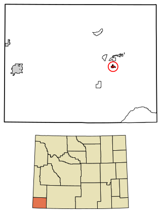
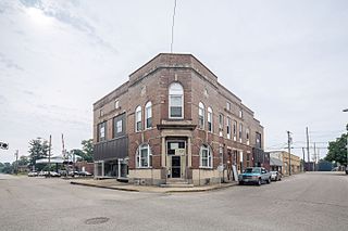
Mountain View is a town in Uinta County, Wyoming, United States. The population was 1,286 at the 2010 census.

References

  1. "2020 U.S. Gazetteer Files". United States Census Bureau. Retrieved March 16, 2022.
  2. 1 2 U.S. Geological Survey Geographic Names Information System: Owensville, Indiana
  3. 1 2 "U.S. Census website". United States Census Bureau . Retrieved January 31, 2008.
  4. Peattie, Elia Wilkinson (1897). History of Gibson County, Indiana. Cook & McDowell Publications. p. 13.
  5. Stormont, Gil R. (1914). History of Gibson County, Indiana: Her People, Industries and Institutions. B.F. Bowen. p. 343.
  6. Steve Malone (2012). The First Malone Families to Settle in Gibson County, Indiana Territory: Volume 1. self published. p. 5.
  7. "Family, friends come together to help after tornado in Gibson County".
  8. 2024 Solar Eclipse
  9. "US Gazetteer files: 2010, 2000, and 1990". United States Census Bureau. February 12, 2011. Retrieved April 23, 2011.
  10. "G001 - Geographic Identifiers - 2010 Census Summary File 1". United States Census Bureau. Archived from the original on February 13, 2020. Retrieved July 17, 2015.
  11. "Owensville, Indiana Climate Classification (Weatherbase)". Weatherbase.
  12. "Census of Population and Housing". Census.gov. Retrieved June 4, 2015.
  13. "U.S. Census website". United States Census Bureau . Retrieved December 11, 2012.
  14. "Indiana public library directory" (PDF). Indiana State Library. Archived from the original (PDF) on February 18, 2017. Retrieved March 7, 2018.