
Gibson County is a county in the southwestern part of the U.S. state of Indiana. As of the 2010 United States Census, the population was 33,503. The county seat is Princeton.

Gibson City is a city in Ford County, Illinois, United States. The population was 3,407 at the 2010 census.

Haubstadt is the second largest town, after Fort Branch, and fourth largest community in Gibson County, Indiana, United States. The population was 1,577 at the 2010 census. Haubstadt has recently become a bedroom community of Evansville and such, is part of the Evansville, Indiana, Metropolitan Area.

Mackey is a town in Barton Township, Gibson County, Indiana, United States. With a population of 106 at the 2010 census, Mackey is the smallest incorporated community in Gibson County and one of the smallest incorporated communities in the state.

Princeton is the largest city in and the county seat of Patoka Township, Gibson County, Indiana, United States. The population was 8,301 at the 2020 United States Census, and it is part of the greater Evansville, Indiana, Metropolitan Area.

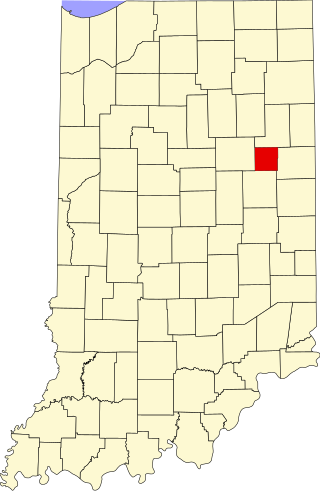
Johnson Township is one of fourteen townships in Clinton County, Indiana. As of the 2010 census, its population was 511 and it contained 209 housing units. The township was named for Richard M. Johnson, a military officer and later vice president of the United States.

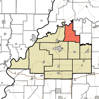
Barton Township is one of ten townships in Gibson County, Indiana. As of the 2010 census, its population was 1,677 and it contained 720 housing units. Somerville is the township seat.
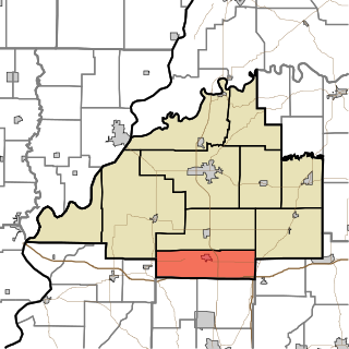
Johnson Township is one of ten townships in Gibson County, Indiana. As of the 2010 census, its population was 4,094 and it contained 1,605 housing units.

Montgomery Township is the largest of the ten townships in Gibson County, Indiana as well as one of the largest townships by area in Southwestern Indiana, USA. At the 2010 census, its population was 3,996 and it contained 1,645 housing units, 75% of which were in areas adjacent to Owensville. Montgomery Township is served by the South Gibson School Corporation. Gibson Generating Station and Gibson Lake are located at the northern end of Montgomery Township.

Union Township is one of ten townships in Gibson County, Indiana. As of the 2010 census, its population was 4,197 and it contained 1,779 housing units, more than 90% of which live either within or in areas adjacent to the town of Fort Branch. Fort Branch is the township seat. Nearly all of the Toyota Motor Manufacturing Indiana Complex is located within Union Township.
Washington Township is one of ten townships in Gibson County, Indiana. As of the 2010 census, its population was 785 and it contained 345 housing units. Like Wabash Township, Washington Township also has no organized seat within the township, despite its two corporation-worthy towns Mount Olympus and Wheeling. Patoka, in White River Township, serves as the seat.
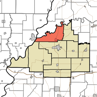
White River Township is one of ten townships in Gibson County, Indiana. As of the 2010 census, its population was 1,689 and it contained 817 housing units.

Armstrong Township is one of eight townships in Vanderburgh County, Indiana, United States. As of the 2010 census, its population was 1,599 and it contained 634 housing units.

Scott Township is one of eight townships in Vanderburgh County, Indiana, United States. As of the 2010 census, its population was 8,528 and it contained 3,343 housing units. In recent years, Scott Township has become one of the fastest-growing townships in the county.

Greer Township is one of ten townships in Warrick County, Indiana, United States. As of the 2010 census, its population was 1,883 and it contained 769 housing units.
Renner is an extinct American village in Indiana's Blackford County. Although Renner has been listed as a “populated place” by the U.S. Geological Survey, this description is misleading. Renner was a railroad stop on the Pittsburgh, Cincinnati and St. Louis Railroad. The land around the railroad stop was originally used to supply timber for railroad crossties, and eventually became a livestock farm. Housing for the families of the employees of the livestock farm was also located nearby. Although it is not known for certain, Renner is thought to have been named for railroad executive John W. Renner. Renner was an executive of the Pittsburgh, Cincinnati and St. Louis Railroad, and later the Pennsylvania Railroad, and retired with over 50 years of railroad experience. Another community, Rennerdale, Pennsylvania, was named in his honor in 1895.
Saint James is a small hamlet located roughly 1 mile south of Haubstadt, Indiana in Johnson Township, Gibson County, Indiana, United States, and 1/4 mile north of Vanderburgh County.

Wheeling is an unincorporated community in Washington Township, Gibson County, Indiana, United States. The community contains a historic covered bridge over the Patoka River, the Wheeling Bridge, completed in 1877.

The Underground Railroad in Indiana was part of a larger, unofficial, and loosely-connected network of groups and individuals who aided and facilitated the escape of runaway slaves from the southern United States. The network in Indiana gradually evolved in the 1830s and 1840s, reached its peak during the 1850s, and continued until slavery was abolished throughout the United States at the end of the American Civil War in 1865. It is not known how many fugitive slaves escaped through Indiana on their journey to Michigan and Canada. An unknown number of Indiana's abolitionists, anti-slavery advocates, and people of color, as well as Quakers and other religious groups illegally operated stations along the network. Some of the network's operatives have been identified, including Levi Coffin, the best-known of Indiana's Underground Railroad leaders. In addition to shelter, network agents provided food, guidance, and, in some cases, transportation to aid the runaways.
Mounts is an unincorporated community in Gibson County, Indiana, in the United States.


