Lyles Station, Indiana

Last updated
Lyles Station, Indiana
USA Indiana location map.svg
Red pog.svg
Lyles Station
Usa edcp location map.svg
Red pog.svg
Lyles Station
Coordinates: 38°22′13″N87°39′33″W / 38.37028°N 87.65917°W / 38.37028; -87.65917 Coordinates: 38°22′13″N87°39′33″W / 38.37028°N 87.65917°W / 38.37028; -87.65917
Country United States
State Indiana
County Gibson
Township Patoka
Lyle's Purchase1849
Elevation
400 ft (100 m)
Population
 (2000)
  Total401
ZIP code
47670
FIPS code 18-45414 [1]
GNIS feature ID438427 [2]
Website http://lylesstation.org/

Lyles or Lyles Station is an unincorporated community in Patoka Township, Gibson County, Indiana. The community dates from 1849, although its early settlers first arrived in the 1830s, and it was formally named Lyles Station in 1886 to honor Joshua Lyles, a free African American who migrated with his family from Tennessee to Indiana around 1837. Lyles Station is one of Indiana's early black rural settlements and the only one remaining. The rural settlement reached its peak in the years between 1880 and 1912, when major structures in the community included the railroad depot, a post office, a lumber mill, two general stores, two churches, and a school. By the turn of the twentieth century, Lyles Station had fifty-five homes, with a population of more than 800 people. The farming community never fully recovered from the Great Flood of 1913, which destroyed much of the town. Most of its residents left for economic reasons, seeking opportunities for higher paying jobs and additional education in larger cities. By 1997 approximately fifteen families remained at Lyles Station, nearly all of them descended from the original settlers.

Contents

Although most of Indiana's black rural settlements no longer exist as self-contained communities, Lyles Station continues. The restored Lyles Consolidated School building, which serves as a local living history museum and a community center, and the Wayman Chapel African Methodist Episcopal Church, are two remaining points of interest in Lyles Station.

The "Power of Place" exhibition in the Smithsonian's National Museum of African American History and Culture on the National Mall in Washington, D.C., which opened in 2016, features Lyles Station as part of its exhibition on black rural communities in the Midwest. [3] The exhibit includes hundreds of items from the Lyles Station area, including a horse-drawn plow used by Joshua Lyles, clothing, a quilt, and soil from the Greer family farm which has been farmed by the Greer family for over 150 years. [4]

Geography

Lyles Station is located in Patoka Township, Gibson County, Indiana, [5] at 38°22′13″N87°39′33″W / 38.37028°N 87.65917°W / 38.37028; -87.65917 , approximately 4.5 miles (7.2 km) west of Princeton, in the southwestern part of the state. [6] By 1900, the settlement bordered the Patoka River on the north; old U.S. 41 on the east; Indiana State Route 64 on the south; and the boundary line with the Illinois state line on the west. [7] Its proximity to the White, Patoka, and Wabash Rivers, makes it especially susceptible to flooding.[ citation needed ]

Demographics

Lyles Station, whose early settlers arrived in the 1830s, dates from 1849 and is one of Indiana's early first black rural settlements. As of 2008 it is the only one remaining. [8] Two other black rural settlements were established nearby: Roundtree, north of Lyles Station, and Sand Hill, two miles south. [9] By the turn of the century, with approximately 800 residents, Lyles Station reached its peak as an active farming community. Lyles Station's population declined after a major flood in 1913; few residents and homes remain. [6]

History

Lyles Station is named in honor of Joshua Lyles (alternate spelling of Liles or Lisles), who was a free African American born around 1800, in Henry County, Virginia. [10] He moved with his family to Montgomery County, Tennessee, as a boy and was raised in Springfield, Tennessee. Joshua and his wife, Carparta (Clara), migrated to Indiana around 1837. (Six of the couple's thirteen children were born in Tennessee, before their departure.) [5]

Numerous articles written about Joshua Lyles assert, without any evidentiary verification, that he was born a slave and freed when he was twenty-eight years old. More recent scholarship citing archival records in Virginia, Tennessee, and Indiana provides documentation of family members' status as free persons. [11] A reprint of an Indianapolis News article appearing in the Fort Wayne Evening Sentinel on July 26, 1902, may have initiated the information about Joshua Lyles being a freed slave. [12]

Joshua Lyles was among the community's early pioneer settlers. He arrived about 1837 with members of his family. The Lyles family bought land near the confluence of the White, Patoka, and Wabash Rivers in what is now Patoka Township, Gibson County, Indiana. Joshua and his father, John, are listed in the 1840 census for the township as two of ten free black men who were heads of household. [5] [13] The other free black men listed as heads of households in the township's 1840 census were Nelson Bass, Joel Stewart, John A. Morland, Robert Cole, Banister Chaves, Thomas McDaniel, Isaac Williams, and Duke Anderson. [14]

Joshua Lyles appeared to have been a successful farmer by 1850. The Agricultural Schedule for the 1850 census identifies Joshua Lyles as the owner of 320 acres (130 hectares) of land, 60 acres (24 hectares) of improved land and 260 acres (110 hectares) unimproved, with a farm valued at $500. Farm implements were valued at $10, the estimated value of his livestock at $247, and the value of the animals slaughtered was assessed at $99. The Schedule also indicates that the previous year (1849), Lyles had 4 horses, 10 cows, and 50 hogs. The Lyles farm produced 150 pounds (68 kg) of butter, 10 pounds (4.5 kg) of maple sugar, 60 pounds (27 kg) of honey, and 500 bushels of Indian corn. [14] [15] [16] Joshua Lyles continued farming in Gibson County, eventually increasing his holdings to 1,200 acres (490 hectares). He died in 1885. [17] In addition to Joshua, some of his siblings, and his father, three more of Lyles's siblings had moved to the Patoka Township community by the 1860s. [14]

Shortly after the Civil War, Joshua Lyles returned to Tennessee to encourage family friends, free blacks, and newly emancipated slaves to settle in Indiana. [7] He also provided land to further the settlement's development. In 1864 Lyles donated the land to build a subscription school in the community. [5] In 1866 the community was granted a U.S. post office, which was replaced with rural route delivery service in 1917. [9] Thomas Cole, another early settler, donated 1 acre (0.40 hectares) of land for the community's first cemetery. [7] In 1870 Joshua Lyles donated 60 acres (24 hectares) of land to the Airline Railroad. In exchange, the railroad built a train station that provided the community with the means to export crops outside the local area. The railroad also offered passenger and mail service, which helped to speed up the settlement's growth. [17]

Lyles Station reached its peak in the years between 1880 and 1912, when major structures in the community included the railroad depot, a post office, a lumber mill, a school, two churches, and two general stores. [18] The community incorporated and was formally named Lyles Station in 1886 in honor of Joshua Lyles. By the turn of the twentieth century, the settlement had fifty-five homes, with a population of more than 800 people. [5]

Unusually heavy rains in the Midwest caused the White, Wabash, and Patoka Rivers to overflow their banks during the Great Flood of 1913. The catastrophic flood destroyed much of Lyles Station. [18] The community never fully recovered from the flood. Most of its residents left for economic reasons. Agriculture trends favored large farming operations over the small family farms such as those at Lyles Station. Former residents sought a less risky existence and better opportunities for higher paying jobs and additional education in larger cities. [19] By 1997 approximately fifteen families remained at Lyles Station, nearly all of them descended from the original settlers. [18] About six families remain in Lyles Station as of mid-2007.[ citation needed ]

Although most of Indiana's black rural settlements no longer exist as self-contained communities, Lyles Station continues. The community hosts annual reunions and its advocacy group, the Lyles Station Historic Preservation Corporation, preserves its heritage. [20] [21] The National Museum of African American History and Culture, slated to open its new building in Washington, D.C., in 2016, plans to feature Lyles Station as part of its exhibition on black rural communities in the Midwest. [22]

Education

The first school in what became Lyles Stations was subscription school, where parents paid a fee for their children to attend. Established about 1865, its classes were held in a local church building. The community's second school, a three-room schoolhouse, replaced the earlier school. It was built across the road from the Wayman Chapel African Methodist Episcopal Church. [23]

The restored Lyles Consolidated School building Lyles Station.jpg
The restored Lyles Consolidated School building

Lyles Consolidated School, which now serves as a community center and museum, was Lyles Station's third school. Although the population of Lyles Station declined after the flood of 1913, a new school was erected to educate the remaining children of the community, when older schools at Lyles Station and nearby Sand Hill and Sugar Bluff were closed as part of a statewide trend towards school consolidation. [24] The school opened in 1919 and was an integrated school until 1922, when it became an all-black public school. (White students were enrolled at Baldwin Heights School in Patoka Township.) Lyles Stations's school was integrated once again in the 1950s; it closed in 1958 due to declining enrollment. [23]

Following its formation in 1997, the Lyles Station Historic Preservation Corporation began plans to restore Lyles Consolidated School for use as a local heritage classroom, living history museum, and community center. The school was listed on the National Register of Historic Places in 1999. After decades of deterioration, fundraising efforts and additional grants provided the financial resources needed to restore the school building to serve as a community gathering place and museum. [18] [21] [25]

Religion

Two churches were established at Lyles Station: Hardshell Baptist Church and Wayman Chapel African Methodist Episcopal Church. [9] As of 2008 Wayman Chapel AME Church continued to hold regular Sunday services, with an average attendance of fifteen to twenty people. It is the only remaining AME church in Indiana that is located in an agricultural community. [26]

Transportation

The Lyles Station train depot for the Louisville-Saint Louis Railroad line, a division of the Southern Railway, provided the community with access to a wider area. Freight, passenger, and mail service also helped increase the settlement's growth. Passenger service at the local depot was discontinued after the community's population declined. [17] A Norfolk Southern railway line runs along the north of the site.[ citation needed ]

Points of interest

The restored Lyles Consolidated School building, which serves as a community center and local history museum, and the Wayman Chapel AME Church, are two remaining points of interest in Lyles Station to remind residents and visitor of its heritage as one of Indiana's early rural black communities. [6]

While the Gibson Community Foundation helped with funding for the building restoration, the Lyles Station Historic Preservation Corporation also received grants from the United States Department of Agriculture & Build Indiana. The corporation chose two individuals noted as being experts in physical restoration to lead the project: Architect George Ridgway and contractor Jeffrrey Koester. [27]

Notable people

Notes

  1. "U.S. Census website". United States Census Bureau . Retrieved 2008-01-31.
  2. "Lyles Station, Indiana". Geographic Names Information System . United States Geological Survey . Retrieved 2009-10-17.
  3. Corley, Cheryl. “In Indiana, The Last Remnants Of America's Free African-American Settlements.” NPR, NPR, 22 Sept. 2016, www.npr.org/sections/codeswitch/2016/09/22/4949841
  4. Evans, Tim. “Lyles Station a Secret No More with African-American History Museum's Dedication.” Indianapolis Star, IndyStar, 24 Sept. 2016, www.indystar.com/story/news/2016/09/24/lyles-station-secret-no-more-african-american-history-museums-dedication/91021008/.
  5. 1 2 3 4 5 "Early Black Settlements: Gibson County". Indiana Historical Society. Retrieved 2016-02-16.
  6. 1 2 3 "History". Lyles Station Historic Preservation Corporation. Retrieved 2016-02-11.
  7. 1 2 3 Carl Lyles (November 1982). "The Story of Lyles Station, Indiana: Yesterday and Today". Black History News and Notes. Indianapolis: Indiana Historical Society (11): 4.
  8. "There Is No Place Like Home". Rural Development Spotlight - Indiana. United States Department of Agriculture. Archived from the original on 2008-05-13. Retrieved 2008-09-25.
  9. 1 2 3 Lyles, "The Story of Lyles Station, Indiana", p. 5.
  10. The Registry of Negroes in Gibson County, Indiana (Patoka township), ca. 1852.
  11. On July 1, 1823, the Probate Court of Montgomery County, Tennessee, determined that several family members, including Joshua; his grandfather, James; and his father, John; among others, were born free persons before their arrival in Tennessee. The Tennessee court issued them official documents known as "freedom papers" to recognize their status. The court's decision was based on an affidavit filed by Colonel Joseph Hopson, an American Revolutionary War veteran, who attested that he had known the family when he lived in Virginia and that he knew specific members of the family, including Joshua, were free black persons when they resided in Virginia. See Arlene Blanks Polk (Fall 2013). "The Truth About Joshua Lyles: A Free African American Settler of Lyles Station, Indiana". Traces of Indiana and Midwestern History. Indianapolis: Indiana Historical Society. 25 (4): 33–34. See also, Montgomery County, Tennessee Court Minutes, volume 2, 1823–1824, on microfilm in the Montgomery County Department of Preservation of Records' Archives in Clarksville, Tennessee, and Arlene B. Polk. "The Settlement of Lyles Station by Free African Americans: John Lyles". Freeafricanamericans.com. Retrieved 2016-02-18.
  12. The story of Joshua Lyles's liberation by a benevolent master was often repeated in subsequent articles and books without reference or confirmation. See Polk, "The Truth About Joshua Lyles", p. 36. For other works with content about Joshua Lyles's status as a freed slave see: "History". Lyles Station Historic Preservation Corporation. Retrieved 2016-02-11.Carl C. Lyles, Sr. (1984). Lyles Station, Indiana: Yesterday and Today. Evansville: University of Southern Indiana. pp. 2–3. OCLC   20522522.Bill Shaw (1997-02-02). "A Beacon of History". The Indianapolis Star. p. 3.Rebecca C. Zorich & Cornelius O’Brien (1995). Our Historical Perspective. 1. The African-American Landmarks Committee, Historic Landmarks Foundation of Indiana. p. 3.Slaves Sought Freedom. Princeton Indiana Genealogy, Lyles Station Historical Preservation Corporation. 2000. p. 1."Lyles Station Historical Marker Ceremony". Black History News and Notes. Indianapolis: Indiana Historical Society. 1 (89): 2. August 2002.Randy K. Mills (August 2005). "They Defended Themselves Nobly: A Story of African American Empowerment in Evansville, Indiana, 1857". Black History News and Notes. Indianapolis: Indiana Historical Society. 1 (101): 3.
  13. Polk, "The Truth About Joshua Lyles", pp. 33–34.
  14. 1 2 3 Polk, "The Truth About Joshua Lyles", p. 36.
  15. U.S. Census of 1850, Patoka township, Gibson County, Indiana, roll M432 147, page 6, image 12, Joshua Lyles household.
  16. Agricultural Schedule to U.S. Census of 1850, Gibson County, Indiana.
  17. 1 2 3 Lyles, "The Story of Lyles Station, Indiana", p. 4, and Polk, "The Truth About Joshua Lyles", p. 37.
  18. 1 2 3 4 "New Smithsonian Museum Includes Story of Lyles Station". News Archive. Indiana Landmarks. 2015-11-11. Retrieved 2016-02-16.
  19. Lyles, "The Story of Lyles Station, Indiana", pp. 5–6.
  20. Wilma L. Moore (Winter 2015). "A Treasure Hunt: Black Rural Settlements in Indiana by 1870". Traces of Indiana and Midwestern History. Indianapolis: Indiana Historical Society. 27 (1): 24.
  21. 1 2 "Historic Preservation Corporation". Lyles Station Historic Preservation Corporation. Retrieved 2016-02-16.
  22. Moore, "A Treasure Hunt", p. 33.
  23. 1 2 "History", Lyles Station Historic Preservation Corporation website, and Lyles, "The Story of Lyles Station, Indiana", p. 5.
  24. Lyles, Lyles Station, Indiana, pp. 30–31.
  25. "National Register Information System". National Register of Historic Places . National Park Service. March 13, 2009.
  26. Susan Orr (2008-08-02). "Wayman Chapel: Small But Active, It Remains Strong Link to a Unique Indiana Community". Evansville Courier and Press. Evansville, Indiana. Retrieved 2016-02-18.
  27. "About Us". Lyles Station.
  28. "Museum". Lyles Station Historic Preservation Corporation. Retrieved 2011-03-11.
  29. Arville L. Funk (May 1986). "Lt. Aaron R. Fisher–Hoosier Hero". Black History News and Notes. Indianapolis: Indiana Historical Society (25): 6.
  30. "Documentary on early radiation experiments in southern Indiana". Vincennes University. Retrieved 2016-02-19.
  31. "Biographical Sketch" in Matthias Nolcox Oral History Interview, ca. 1979, Collection Guide (PDF). Indianapolis: Indiana Historical Society. Emma Lou Thornbrough (1982). This Far By Faith. Indianapolis: Indiana Committee for the Humanities. p. 2. OCLC   8870719.
  32. Jim Harger (2009-11-04). "Grand Rapids First Black Mayor Rev. Lyman Parks Remembered for Honesty, Calm". mlive.com. Retrieved 2016-02-17.
  33. Lyles, Lyles Station, Indiana, p. 34.

Related Research Articles

Gibson County, Indiana U.S. county in Indiana

Gibson County is a county in the southwestern part of the U.S. state of Indiana. As of the 2010 United States Census, the population was 33,503. The county seat is Princeton.

Princeton, Indiana City in Indiana, United States

Princeton is a city in Patoka Township, Gibson County, Indiana, United States. The population was 8,644 at the 2010 census, and it is part of the greater Evansville, Indiana, Metropolitan Area. The city is the county seat of and the largest city in Gibson County.

Evansville, Indiana City in Indiana, United States

Evansville is a city in, and the county seat of, Vanderburgh County, Indiana. The population was 117,429 at the 2010 census, making it the state's third-most populous city after Indianapolis and Fort Wayne, the largest city in Southern Indiana, and the 232nd-most populous city in the United States. It is the commercial, medical, and cultural hub of Southwestern Indiana and the Illinois–Indiana–Kentucky tri-state area, home to over 911,000 people. The 38th parallel crosses the north side of the city and is marked on Interstate 69.

Patoka River

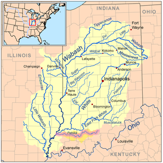
The Patoka River is a 167-mile-long (269 km) tributary of the Wabash River in southwestern Indiana in the United States. It drains a largely rural area of forested bottomland and agricultural lands among the hills north of Evansville.

Angel Mounds United States historic place

Angel Mounds State Historic Site, an expression of the Mississippian culture, is an archaeological site managed by the Indiana State Museum and Historic Sites that includes more than 600 acres of land about 8 miles (13 km) southeast of present-day Evansville, in Vanderburgh and Warrick counties in Indiana. The large residential and agricultural community was constructed and inhabited from AD 1100 to AD 1450, and served as the political, cultural, and economic center of the Angel chiefdom. It extended within 120 miles (190 km) of the Ohio River valley to the Green River in present-day Kentucky. The town had as many as 1,000 inhabitants at its peak, and included a complex of thirteen earthen mounds, hundreds of home sites, a palisade (stockade), and other structures.

Indiana Landmarks

Indiana Landmarks is America's largest private statewide historic preservation organization. Founded in 1960 as Historic Landmarks Foundation of Indiana by a volunteer group of civic and business leaders led by Indianapolis pharmaceutical executive Eli Lilly, the organization is a private non-governmental organization with nearly 6,000 members and an endowment of over $40-million. The organization simplified its name to Indiana Landmarks in 2010.

Gibson Generating Station

The Gibson Generating Station is a coal-burning power plant located at the northernmost end of Montgomery Township, Gibson County, Indiana, United States. It is close to the Wabash River, 1.5 miles southeast of Mount Carmel, Illinois, 2 miles south of the mouth of the Patoka River, and 4 miles south of the mouth of the White River. The closest Indiana communities are Owensville 7.5 miles to the southeast of the plant, and Princeton, 10.5 miles to the east. With a 2013 aggregate output capacity among its five units of 3,345 megawatts, it is the largest power plant run by Duke Energy, the tenth-largest electrical plant in the United States, With the reduction of Nanticoke Generating Station, it became the largest coal power plant in North America by generated power late in 2012. Also on the grounds of the facility is a 3,000-acre (12 km2) large man-made lake called Gibson Lake which is used as a cooling pond for the plant. Neighboring the plant is a Duke-owned, publicly accessible access point to the Wabash River near a small island that acts as a wildlife preserve. This is the nearest boat-ramp to Mount Carmel on the Indiana side of the river. Located immediately south of Gibson Lake, the plant's cooling pond, is the Cane Ridge National Wildlife Refuge, the newest unit of the Patoka River National Wildlife Refuge and Management Area. Opened in August 2006, this 26-acre (11 ha) area serves as a nesting ground for the least tern, a rare bird. Cane Ridge NWR is reportedly the easternmost nesting ground for the bird in the U.S. The Gibson Generating Station is connected to the power grid via five 345 kV and one 138 kV transmission lines to 79 Indiana counties including the Indianapolis area and a sixth 345 kV line running from GGS to Evansville and Henderson, owned by Vectren and Kenergy.

Lyles Consolidated School United States historic place

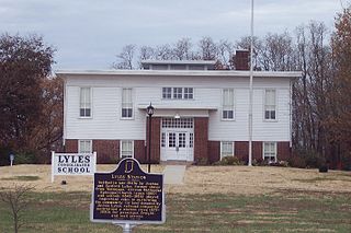
Lyles Consolidated School is a historic school in Lyles Station, Indiana. The third school to be located in Lyles Station, it was opened in 1919 and used until 1958. Abandoned for nearly forty years, it had deteriorated almost to the point of total collapse by 1997. The Lyles Station Historic Preservation Corporation was founded in June 1997, to preserve and promote the history of the Lyles Station community. Its major project was restoration of the schoolhouse, intending to use it as a living history museum to educate others both about Lyles Station's history and the daily school routine in the early twentieth century. The school was listed on the National Register of Historic Places in 1999. Restoration of the site was completed in 2003.

Montgomery Township, Gibson County, Indiana Township in Indiana, United States

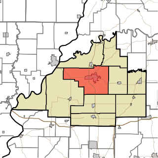
Montgomery Township is the largest of the ten townships in Gibson County, Indiana as well as one of the largest townships by area in Southwestern Indiana. As of the 2010 census, its population was 3,996 and it contained 1,645 housing units, 75% of which live in areas adjacent to Owensville. Montgomery Township is served by the South Gibson School Corporation. Gibson Generating Station and Gibson Lake are located at the northern end of Montgomery Township.

Patoka Township, Gibson County, Indiana Township in Indiana, United States

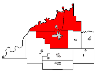
Patoka Township is one of ten townships in Gibson County, Indiana, United States. As of the 2010 census, its population was 11,864 and it contained 5,341 housing units. It is the largest township in population, accounting for roughly 30% of the county's total population.

South Gibson School Corporation

The South Gibson School Corporation is the largest of the three public school governing institutions in both enrollment and territory covered in Gibson County, Indiana as well as one of the ten largest in enrollment in Southwestern Indiana. The SGSC is responsible for a district including four townships of southern and southwestern Gibson County; Johnson, Montgomery, Union, Wabash, and parts of Barton, Center and Patoka Townships within Gibson County as well as drawing in students from Northern Vanderburgh and Posey Counties. It consists of a superintendent, a five-member school board, eight principals and vice principals and employs around 190 teachers and specialists. The SGSC's renovation of the then-35-year-old Gibson Southern High School was complete as of 2010-11 School Year.

North Gibson School Corporation

The North Gibson School Corporation is the second largest of the three public school governing institutions in Gibson County, Indiana, United States as well as one of the twenty largest in enrollment in Southwestern Indiana. The NGSC is responsible for a district including three townships of northern and northeastern Gibson County; Patoka, Washington, and White River. However, the Gibson-Pike-Warrick Special Education Cooperative sends the majority of the special needs students from Pike and Gibson Counties to Princeton Community High School, the high school of the district.

Underground Railroad in Indiana

The Underground Railroad in Indiana was part of a larger, unofficial, and loosely-connected network of groups and individuals who aided and facilitated the escape of runaway slaves from the southern United States. The network in Indiana gradually evolved in the 1830s and 1840s, reached its peak during the 1850s, and continued until slavery was abolished throughout the United States at the end of the American Civil War in 1865. It is not known how many fugitive slaves escaped through Indiana on their journey to Michigan and Canada. An unknown number of Indiana's abolitionists, anti-slavery advocates, and people of color, as well as Quakers and other religious groups illegally operated stations along the network. Some of the network's operatives have been identified, including Levi Coffin, the best-known of Indiana's Underground Railroad leaders. In addition to shelter, network agents provided food, guidance, and, in some cases, transportation to aid the runaways.

Roberts Chapel (Atlanta, Indiana) United States historic place

Roberts Chapel, is a non-denominational church that was originally built in 1847 at Roberts Settlement, one of Indiana's early black pioneer communities. The rural church, whose main building dates from 1858, is located near the present-day town of Atlanta in rural Jackson Township, Hamilton County, Indiana. The chapel was listed on the National Register of Historic Places in 1996.

Bethel A.M.E. Church (Indianapolis, Indiana) United States historic place

The Bethel A.M.E. Church, known in its early years as Indianapolis Station or the Vermont Street Church, is a historic African Methodist Episcopal Church in Indianapolis, Indiana. Organized in 1836, it is the city's oldest African-American congregation. The three-story church on West Vermont Street dates to 1869 and was added to the National Register in 1991. The surrounding neighborhood, once the heart of downtown Indianapolis's African American community, significantly changed with post-World War II urban development that included new hotels, apartments, office space, museums, and the Indiana University–Purdue University at Indianapolis campus. In 2016 the congregation sold their deteriorating church, which will be used in a future commercial development. The congregation built a new worship center at 6417 Zionsville Road in Pike Township, Marion County, Indiana.

Weaver is an unincorporated community in Liberty Township, Grant County, Indiana. Weaver's first settlers were free people of color who migrated from North Carolina and South Carolina to Grant County in the early 1840s. The neighborhood was originally known as Crossroad; however, it was later renamed Weaver in honor of a prominent family of the community. The rural settlement reached its peak in the late 1800s, when its population reportedly reached 2,000. Many of its residents left the community for higher-paying jobs in larger towns during the Indiana's natural gas boom, but more than 100 families remained in the settlement in the early 1920s. Weaver, as with most of Indiana's black rural settlements, no longer exists as a self-contained community, but Weaver Cemetery remains as a community landmark.

Beech Settlement was a rural settlement in Ripley Township, Rush County, Indiana. Its early settlers were free people of color and a small number of free blacks, who came to the area with Quakers. Beech was one of Indiana's early black rural settlements and also one of its largest. The rural neighborhood received its name because of a large stand of beech trees in its vicinity. By 1835 the farming community had a population of 400 residents, but largely due to changing economic conditions, including rising costs of farming, the settlement's population began to decline after 1870. Fewer than six of the Beech families remained by 1920. As with most of Indiana's black rural settlements, Beech Settlement no longer exists. Few major points of interest remain; however, the community's Mount Pleasant Beech Church serves as the site for annual reunions of its friends and the descendants of former residents.

Roberts Settlement was an early rural settlement in Jackson Township, Hamilton County, Indiana. Dating from the 1830s, its first settlers were free people of color, most of whom migrated from Beech Settlement, located 40 miles (64 km) southeast in rural Rush County, Indiana. Many of Roberts Settlement's early pioneers were born in eastern North Carolina and Virginia. Some of its settlers were ex-slaves. The neighborhood received its name from the large contingent of its residents who had the surname of Roberts. By the 1870s the farming community had a population of approximately 300 residents. In the late nineteenth and early twentieth centuries, the settlement's population began to decline, largely due to changing economic conditions that included rising costs of farming. Fewer than six families remained at the settlement by the mid-1920s. Most of Indiana's early black rural settlements, including Roberts Settlement, no longer exist. Roberts Chapel, listed on the National Register of Historic Places, serves as the site for the community's annual reunions of its friends and the descendants of former residents.

Indiana State Federation of Colored Womens Clubs United States historic place

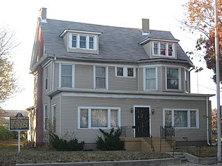
Indiana State Federation of Colored Women's Clubs, also known as the Minor House, is a historic National Association of Colored Women's Clubs clubhouse in Indianapolis, Indiana. The two-and-one-half-story "T"-plan building was originally constructed in 1897 as a private dwelling for John and Sarah Minor; however, since 1927 it has served as the headquarters of the Indiana State Federation of Colored Women's Clubs, a nonprofit group of African American women. The Indiana federation was formally organized on April 27, 1904, in Indianapolis and incorporated in 1927. The group's Colonial Revival style frame building sits on a brick foundation and has a gable roof with hipped dormers. It was listed on the National Register of Historic Places in 1987.

Union Literary Institute Racially integrated school in the United States

The Union Literary Institute, located in rural Randolph County, Indiana, at 8605 East County Road 600 South, Union City, Indiana, was a school founded in 1846 by abolitionist Quakers and free blacks from Ohio, Kentucky, and North Carolina, after the Indiana Legislature decreed in 1843 that "colored students" could not attend the public schools. When founded it was one of only a handful of American schools in which black and white students studied together; it was the first in Indiana, The school closed briefly because of the Civl War. It published a magazine, and survived until 1880.

References