Hazleton, Indiana

Last updated

Town of Hazleton, Indiana
Hazleton-IOOF-town-hall-in.jpg
Hazleton
Gibson County Indiana Incorporated and Unincorporated areas Hazleton Highlighted 1832728.svg
Location of Hazleton in Gibson County, Indiana.
Coordinates: 38°29′21″N87°32′26″W / 38.48917°N 87.54056°W / 38.48917; -87.54056
Country United States
State Indiana
County Gibson
Township White River
Area
[1]
  Total0.35 sq mi (0.90 km2)
  Land0.35 sq mi (0.90 km2)
  Water0.00 sq mi (0.00 km2)
Elevation
[2]
449 ft (137 m)
Population
 (2020)
  Total194
  Density560.69/sq mi (216.30/km2)
Time zone UTC-6 (CST)
  Summer (DST) UTC-5 (CDT)
ZIP code
47640
Area code(s) 812, 930
FIPS code 18-32728 [3]
GNIS feature ID2396992 [2]

Hazleton is a town in White River Township, Gibson County, Indiana, United States. The population was 263 at the 2010 census making it the second smallest community in the county. While having almost no connection to it, it is part of the Evansville, Indiana, Metropolitan Area.

Contents

History

Hazleton is the second-oldest town in Gibson County after Patoka. It was named in honor of Gervas Hazleton, [4] believed to be the second settler to permanently locate to the county. Hazleton first lived in a crude camp lit by large log fires that was a popular stopover for early migrants to the area. [5]

The town was platted in 1856 by Lucius French. T. S. Fuller erected the town's first frame building, and John Breedlove built the town's blacksmith shop. The first steamboat of any note to travel up the White River was the Cleopatria in 1884. [6]

On March 10, 1897, a passenger train of the Evansville and Terre Haute Railroad (now the Chicago & Eastern Illinois) wrecked near Hazleton. An embankment which carried the tracks past the White River had been weakened by the river's flood waters, and collapsed under the weight of the train, causing it to derail. Around a dozen people are believed to have been killed, though most bodies were never found. [7]

Geography

Hazleton is located at 38°29′20″N87°32′30″W / 38.48889°N 87.54167°W / 38.48889; -87.54167 (38.488953, -87.541652). [8] The town is situated along the south bank of the White River in northern Gibson County (the river marks the county line between Gibson and Knox counties). State Road 56 connects the town with U.S. Route 41, which runs northward to Vincennes and southward to the Evansville area. Hazleton is 422 feet (129 m) above sea level.

According to the 2010 census, Hazleton has a total area of 0.33 square miles (0.85 km2), all land. [9]

Demographics

Historical population
CensusPop.Note
1870 356
1880 61873.6%
1890 608−1.6%
1900 75824.7%
1910 648−14.5%
1920 605−6.6%
1930 507−16.2%
1940 5161.8%
1950 498−3.5%
1960 5071.8%
1970 416−17.9%
1980 368−11.5%
1990 357−3.0%
2000 288−19.3%
2010 263−8.7%
2020 194−26.2%
U.S. Decennial Census [10]

2020 census

As of the census [11] of 2020, there were 194 people, 108 households, and 78 families residing in the town. The population density was 797.0 inhabitants per square mile (307.7/km2). There were 120 housing units at an average density of 363.6 per square mile (140.4/km2). The racial makeup of the town was 97.3% White, 2.3% African American, and 0.4% from two or more races. Hispanic or Latino of any race were 0.4% of the population.

There were 108 households, of which 30.6% had children under the age of 18 living with them, 55.6% were married couples living together, 10.2% had a female householder with no husband present, 6.5% had a male householder with no wife present, and 27.8% were non-families. 24.1% of all households were made up of individuals, and 10.2% had someone living alone who was 65 years of age or older. The average household size was 2.44 and the average family size was 2.86.

The median age in the town was 44.9 years. 21.3% of residents were under the age of 18; 6% were between the ages of 18 and 24; 22.8% were from 25 to 44; 35.3% were from 45 to 64; and 14.4% were 65 years of age or older. The gender makeup of the town was 50.2% male and 49.8% female.

2000 census

As of the census [3] of 2000, there were 288 people, 108 households, and 84 families residing in the town. The population density was 841.0 inhabitants per square mile (324.7/km2). There were 119 housing units at an average density of 347.5 per square mile (134.2/km2). The racial makeup of the town was 97.22% White, and 2.78% from two or more races.

There were 108 households, out of which 24.1% had children under the age of 18 living with them, 60.2% were married couples living together, 13.9% had a female householder with no husband present, and 22.2% were non-families. 20.4% of all households were made up of individuals, and 6.5% had someone living alone who was 65 years of age or older. The average household size was 2.67 and the average family size was 3.08.

In the town, the population was spread out, with 21.5% under the age of 18, 11.8% from 18 to 24, 22.2% from 25 to 44, 31.3% from 45 to 64, and 13.2% who were 65 years of age or older. The median age was 40 years. For every 100 females, there were 100.0 males. For every 100 females age 18 and over, there were 93.2 males.

The median income for a household in the town was $31,875, and the median income for a family was $36,406. Males had a median income of $28,750 versus $28,750 for females. The per capita income for the town was $13,156. About 25.0% of families and 25.9% of the population were below the poverty line, including 36.9% of those under the age of eighteen and 12.5% of those 65 or over.

Related Research Articles

<span class="mw-page-title-main">Milltown, Indiana</span> Town in Indiana, United States

Milltown is a town in Whiskey Run Township in Crawford County, Indiana and in Blue River and Spencer townships in Harrison County. The population was 818 at the time of the 2010 census.

<span class="mw-page-title-main">Fort Branch, Indiana</span> Town in Indiana, United States

Fort Branch is the largest town and 2nd largest community in Gibson County, Indiana after Princeton. The population was 2,965 at the 2020 census. It is part of the Evansville, Indiana, Metropolitan Area.

<span class="mw-page-title-main">Francisco, Indiana</span> Town in Indiana, United States

Francisco is the fifth largest town and seventh largest community in Gibson County, Indiana, United States. A town in Center Township, the population was 469 at the 2010 census and was founded in 1851. Local tradition says the town was named for its first settler, a Spanish laborer working on the Wabash and Erie Canal who built a shack in the area. It is part of the Evansville, Indiana, Metropolitan Area.

<span class="mw-page-title-main">Haubstadt, Indiana</span> Town in Indiana, United States

Haubstadt is the second largest town, after Fort Branch, and fourth largest community in Gibson County, Indiana, United States. The population was 1,638 at the 2020 census. Haubstadt has recently become a bedroom community of Evansville and such, is part of the Evansville, Indiana, Metropolitan Area.

<span class="mw-page-title-main">Owensville, Indiana</span> Town in Indiana, United States

Owensville is the third largest town and the smallest of the five larger communities in Gibson County, Indiana, United States. The population was 1,338 in 2020.

<span class="mw-page-title-main">Patoka, Indiana</span> Town in Indiana, United States

Patoka is the fourth largest town and sixth largest community in Gibson County, Indiana, United States. The population was 735 at the 2010 census.

<span class="mw-page-title-main">Princeton, Indiana</span> City in Indiana, United States

Princeton is the largest city in and the county seat of Patoka Township, Gibson County, Indiana, United States. The population was 8,301 at the 2020 United States Census, and it is part of the greater Evansville, Indiana, Metropolitan Area.

<span class="mw-page-title-main">Somerville, Indiana</span> Town in Indiana, United States

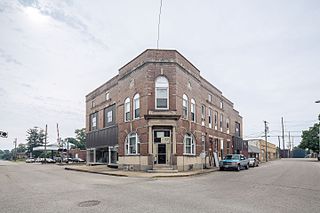
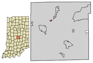
Somerville is a town in Barton Township, Gibson County, Indiana, United States. The population was 293 at the 2010 census, making it the third-smallest community in the county.

<span class="mw-page-title-main">Mooreland, Indiana</span> Town in Indiana, United States

Mooreland is a town in Blue River Township, Henry County, Indiana, United States. The population was 375 at the 2010 census.

<span class="mw-page-title-main">Country Club Heights, Indiana</span> Town in Indiana, United States

Country Club Heights is a town in Anderson Township, Madison County, Indiana, United States. The population was 98 at the 2020 census.

<span class="mw-page-title-main">Paragon, Indiana</span> Town in Indiana, United States

Paragon is a town in Ray Township, Morgan County, in the U.S. state of Indiana. The population was 556 at the 2020 census, down from 659 in 2010.

<span class="mw-page-title-main">Merom, Indiana</span> Town in Indiana, United States

Merom is a town in Gill Township, Sullivan County, Indiana, United States. The population was 228 at the 2010 census. It is part of the Terre Haute Metropolitan Statistical Area. Nearby is Hallador Energy's Merom Generating Station.

<span class="mw-page-title-main">Darmstadt, Indiana</span> Town in Indiana, United States

Darmstadt is a small, German-heritage town primarily located in Scott Township, Vanderburgh County, Indiana, United States. It also extends slightly into Armstrong, Center and German townships. The population was 1,407 at the 2010 census. Darmstadt, located just north of Evansville, is the only other incorporated municipality in Vanderburgh County besides Evansville.

<span class="mw-page-title-main">Chandler, Indiana</span> Town in Indiana, United States

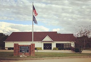
Chandler is a town straddling Ohio and Boon Township in Warrick County, Indiana, United States, located just east of Evansville, Indiana along the Ohio River. The population was 3,693 at the 2020 census, making it Warrick County's second-most populous municipality after Boonville. The town is part of the Evansville metropolitan area with a population of 342,815.

<span class="mw-page-title-main">Elberfeld, Indiana</span> Town in Indiana, United States

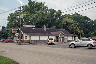
Elberfeld is a town in Greer Township, Warrick County, in the U.S. state of Indiana. The population was 625 as of the 2010 census.

<span class="mw-page-title-main">Hazleton, Iowa</span> City in Iowa, United States

Hazleton is a city in Buchanan County, Iowa, United States. The population was 713 at the time of the 2020 census.

<span class="mw-page-title-main">Somerville, Maine</span> Town in the state of Maine, United States

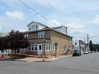
Somerville is a town in Lincoln County, Maine, United States. The population was 600 at the 2020 census. Somerville is located 15 miles east of the state capital, Augusta.

<span class="mw-page-title-main">Kline Township, Schuylkill County, Pennsylvania</span> Township in Pennsylvania, United States

Kline Township is a township in Schuylkill County, Pennsylvania. The population was 1,473 at the 2020 census.

<span class="mw-page-title-main">North Crows Nest, Indiana</span> Town in Indiana, United States

North Crows Nest is a town in Washington Township, Marion County, Indiana, United States. It is approximately 7 miles (11 km) north of downtown Indianapolis. The population was 44 at the 2020 census. It has existed as an "included town" since 1970, when it was incorporated into Indianapolis as part of Unigov. It is part of Indianapolis, but retains town governmental powers under IC 36-3-1-11.

<span class="mw-page-title-main">Spring Hill, Indiana</span> Town in Indiana, United States

Spring Hill is a town in Marion County, Indiana, United States. The population was 95 at the 2020 census. It has existed as an "included town" since 1970, when it was incorporated into Indianapolis as part of Unigov. It is part of Indianapolis, but retains town governmental powers under IC 36-3-1-11.

References

  1. "2020 U.S. Gazetteer Files". United States Census Bureau. Retrieved March 16, 2022.
  2. 1 2 U.S. Geological Survey Geographic Names Information System: Hazleton, Indiana
  3. 1 2 "U.S. Census website". United States Census Bureau . Retrieved January 31, 2008.
  4. Peattie, Elia Wilkinson (1897). History of Gibson County, Indiana. Cook & McDowell Publications. p. 14.
  5. Gil R. Stormont, History of Gibson County, Indiana (B.F. Bowen, 1914), p. 377.
  6. James T. Tartt and Company, History of Gibson County, Indiana (1884), p. 187.
  7. Stormont, History of Gibson County, Indiana, pp. 108-109.
  8. "US Gazetteer files: 2010, 2000, and 1990". United States Census Bureau. February 12, 2011. Retrieved April 23, 2011.
  9. "G001 - Geographic Identifiers - 2010 Census Summary File 1". United States Census Bureau. Archived from the original on February 13, 2020. Retrieved July 17, 2015.
  10. "Census of Population and Housing". Census.gov. Retrieved June 4, 2015.
  11. "U.S. Census website". United States Census Bureau . Retrieved December 11, 2012.