Hayden, Indiana

Last updated

Hayden, Indiana
Hayden Cemetery, Hayden, IN.jpg
Hayden Cemetery
Jennings County Indiana Incorporated and Unincorporated areas Hayden Highlighted 1832584.svg
Location of Hayden in Jennings County, Indiana
USA Indiana location map.svg
Red pog.svg
Hayden
Usa edcp location map.svg
Red pog.svg
Hayden
Coordinates: 38°58′17″N85°44′20″W / 38.97139°N 85.73889°W / 38.97139; -85.73889
Country United States
State Indiana
County Jennings
Township Spencer
Area
[1]
  Total2.47 sq mi (6.41 km2)
  Land2.47 sq mi (6.41 km2)
  Water0.00 sq mi (0.00 km2)
Elevation
[2]
604 ft (184 m)
Population
 (2020)
  Total501
  Density202.51/sq mi (78.18/km2)
ZIP code
47245
GNIS feature ID2587019 [2]
FIPS code 18-32584

Hayden (also Hardenburgh or Six Mile) is an unincorporated community and census-designated place (CDP) in central Spencer Township, Jennings County, Indiana, United States. As of the 2020 census it had a population of 501. [3]

Contents

Geography

It lies along CR700W, west of the town of Vernon, the county seat of Jennings County. [4] U.S. Route 50 passes through the CDP south of the village center; the highway leads northeast 7 miles (11 km) to North Vernon and west 8 miles (13 km) to Seymour.

The Hayden post office has the ZIP code of 47245. [5]

Demographics

Historical population
CensusPop.Note
2020 501
U.S. Decennial Census [6]

As of the 2020 census, Hayden had a population of 501. Of those residents, 459 were white, three were Black, four were Native American or Alaskan Native, two were of some other race, and 33 were of two or more races. [3]

History

Hayden was platted in 1854. [7]

Notable people

Climate

The climate in this area is characterized by hot, humid summers and generally mild to cool winters. According to the Köppen Climate Classification system, Hayden has a humid subtropical climate, abbreviated "Cfa" on climate maps. [11]

Related Research Articles

<span class="mw-page-title-main">Jennings County, Indiana</span> County in Indiana, United States

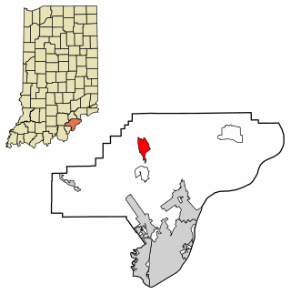
Jennings County is a county located in the U.S. state of Indiana. As of 2020, the population was 27,613. The county seat is Vernon.

<span class="mw-page-title-main">Henryville, Indiana</span> Census-designated place in Indiana, United States

Henryville is a census-designated place (CDP) in Monroe Township, Clark County, in the U.S. state of Indiana. The population was 1,905 at the 2010 census.

<span class="mw-page-title-main">English, Indiana</span> Town in Indiana, United States

English is a town and the county seat of Crawford County, Indiana, United States. The population was 645 at the 2010 census, making it one of Indiana's smallest county seats. The settlement was named Hartford (1839-1884) prior to its incorporation.

<span class="mw-page-title-main">Huntingburg, Indiana</span> City in Indiana, United States

Huntingburg is a city in Patoka Township, Dubois County, in the U.S. state of Indiana. The population was 6,362 at the 2020 census.

<span class="mw-page-title-main">Wellington, Kansas</span> City in Sumner County, Kansas

Wellington is a city in and the county seat of Sumner County, Kansas, United States. As of the 2020 census, the population of the city was 7,715.

<span class="mw-page-title-main">Crosby, Texas</span> Census-designated place in Texas, United States

Crosby is a census-designated place in Harris County, Texas, United States. The population was 3,417 at the 2020 census.

<span class="mw-page-title-main">Timonium, Maryland</span> Census-designated place in Maryland, United States

Timonium is a census-designated place (CDP) in Baltimore County, Maryland, United States. As of the 2010 census it had a population of 9,926. Prior to 2010 the area was part of the Lutherville-Timonium CDP.

<span class="mw-page-title-main">North Vernon, Indiana</span> City in Indiana, United States

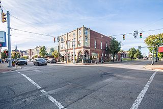
North Vernon is a city in Jennings County, Indiana, United States. The population was 6,608 as of the 2020 census.

<span class="mw-page-title-main">Dola, Ohio</span> Census-designated place in Ohio, United States

Dola is a census-designated place in central Washington Township, Hardin County, Ohio, United States. As of the 2020 United States Census it had a population of 143. It has a post office with the ZIP code 45835.

<span class="mw-page-title-main">Damascus, Ohio</span> Census-designated place in Ohio, United States

Damascus is an unincorporated community and census-designated place in southern Mahoning and northern Columbiana counties in the U.S. state of Ohio. As of the 2020 census, it had a population of 418. The community lies at the intersection of U.S. Route 62 and State Routes 173 and 534.

<span class="mw-page-title-main">Haydenville, Ohio</span> United States historic place

Haydenville is an unincorporated community and census-designated place (CDP) in southern Green Township, Hocking County, Ohio, United States. As of the 2020 census the population of the CDP was 337.

<span class="mw-page-title-main">Deputy, Indiana</span> Census-designated place in Indiana, United States

Deputy is an unincorporated community and census-designated place (CDP) in Graham Township, Jefferson County, Indiana, United States. By road it is approximately 18 miles (29 km) northwest of Madison, the county seat. As of the 2010 census it had a population of 86.

Kent is an unincorporated community and census-designated place (CDP) in Republican Township, Jefferson County, Indiana, United States. As of the 2010 census it had a population of 70.

<span class="mw-page-title-main">Scipio, Indiana</span> Census-designated place in Indiana, United States

Scipio is an unincorporated community and census-designated place (CDP) in Geneva Township, Jennings County, Indiana, United States. As of the 2010 census it had a population of 153.

<span class="mw-page-title-main">Wheeler, Indiana</span> Census-designated place in Indiana, United States

Wheeler is an unincorporated census-designated place (CDP) in northern Union Township, Porter County, in the U.S. state of Indiana. It lies along State Road 130, northwest of the city of Valparaiso. Although Wheeler is unincorporated, it had a post office, with the ZIP code of 46393. The population of Wheeler was 443 at the 2010 census.

<span class="mw-page-title-main">Rome, Indiana</span> Unincorporated community in Indiana, United States

Rome is an unincorporated community along the Ohio River in southeastern Tobin Township, Perry County, in the U.S. state of Indiana.

Paris Crossing is an unincorporated community in southern Montgomery Township, Jennings County, Indiana, United States. It lies along State Road 250, south of the town of Vernon, the county seat of Jennings County. Although Paris Crossing is unincorporated, it has a post office, with the ZIP code of 47270.

Commiskey is an unincorporated community in central Montgomery Township, Jennings County, Indiana, United States. It lies along local roads just west of State Road 3, south of the town of Vernon, the county seat of Jennings County. Although Commiskey is unincorporated, it has a post office, with the ZIP code of 47227.

<span class="mw-page-title-main">Butlerville, Indiana</span> Census-designated place in Indiana, United States

Butlerville is an unincorporated community and census-designated place (CDP) in central Campbell Township, Jennings County, Indiana, United States. As of the 2010 census it had a population of 282.

Wesley is an unincorporated community and census-designated place (CDP) in western Madison County, Arkansas, United States. Wesley is located at the junction of Arkansas highways 74 and 295, 13 miles (21 km) by road west-southwest of Huntsville. Wesley has a post office with ZIP code 72773. It was first listed as a CDP in the 2020 census with a population of 161.

References

  1. "2020 U.S. Gazetteer Files". United States Census Bureau. Retrieved March 16, 2022.
  2. 1 2 U.S. Geological Survey Geographic Names Information System: Hayden, Indiana
  3. 1 2 "Explore Census Data". data.census.gov. Retrieved June 17, 2022.
  4. DeLorme. Indiana Atlas & Gazetteer. 3rd ed. Yarmouth: DeLorme, 2004, p. 52. ISBN   0-89933-319-2.
  5. Zip Code Lookup
  6. "Census of Population and Housing". Census.gov. Retrieved June 4, 2016.
  7. Baker, Ronald L. (October 1995). From Needmore to Prosperity: Hoosier Place Names in Folklore and History . Indiana University Press. p.  160. ISBN   978-0-253-32866-3. This village was platted in 1854.
  8. 1 2 Cava, Pete (2015). Indiana-Born Major League Baseball Players a Biographical Dictionary, 1871-2014. McFarland & Company, Inc., Publishers. ISBN   978-1-4766-2270-5. OCLC   946542327.
  9. Jennings Co, in - Pictorial. Turner Publishing Company. June 15, 1999. ISBN   978-1-56311-521-9.
  10. Davies, Tom (February 8, 2016). "Edgar Whitcomb, Indiana governor with late-life wanderlust, dies at 98". Washington Post. ISSN   0190-8286 . Retrieved June 17, 2022.
  11. Climate Summary for Hayden, Indiana