Argos, Indiana

Last updated

Argos, Indiana
Argos, Indiana.jpg
Marshall County Indiana Incorporated and Unincorporated areas Argos Highlighted 1802044.svg
Location of Argos in Marshall County, Indiana.
Coordinates: 41°14′16″N86°14′46″W / 41.23778°N 86.24611°W / 41.23778; -86.24611
Country United States
State Indiana
County Marshall
Townships Green, Walnut
Area
[1]
  Total1.30 sq mi (3.36 km2)
  Land1.29 sq mi (3.33 km2)
  Water0.01 sq mi (0.03 km2)
Elevation
[2]
728 ft (222 m)
Population
 (2020)
  Total1,777
  Density1,381.80/sq mi (533.68/km2)
Time zone UTC−5 (EST)
  Summer (DST) UTC−5 (EST)
ZIP code
46501
Area code 574
FIPS code [2] [3] 18-02044
GNIS ID [2] [3] 430243
Website townofargos.com

Argos is a town in Green and Walnut townships, Marshall County, Indiana, United States. The population was 1,777 at the 2020 census.

Contents

History

In 1833, Sidney Williams arrived in the area which is now Marshall County and purchased 600 acres (2.4 km2) of land on the present day site of Argos. Mr. Williams built a tavern, an inn, and helped build a section of Michigan Road. Mr. Williams sold his land to Clark Bliven, the man who built the courthouse on the Williams's land. This local place of rest wasn’t considered a town until some time later. On January 8, 1851, John Pleak and Marquis L. Smith, laid out the town of Sidney, which is the predecessor to Argos. The town of Sidney was named in honor of Sidney Williams. On November 6, 1856, the town of Fremont, adjoining Sidney, was laid out by Joseph H. Rhodes. Fremont was named after Col. John C. Fremont, who on November 6, 1856, won the Republican candidate for president. On May 21, 1859, a meeting was held for anyone who was interested in the formation of a new township was held in the school house. The purpose of the meeting was to select a name for the township and appointing a suitable person to be the trustee. The names that were offered up for vote were Argos, Noble, and Richland. Noble was withdrawn. The vote total was Argos 12, Richland 8. The commissioners ordered the Township to be called Walnut Township due to the abundance of walnut trees in the area. John A. Rhodes and Charles Brown were proposed for trustee. Rhodes won by a vote of 18 to 4.

In 1854, the post office was removed from Sidney through political manipulations. Schuyler Colfax, the congressman in the district was asked to name the post office. He had a great interest in Greek history which led him to name the post office Argos, after the ancient Greek city made famous in the Iliad of Homer. Argos was the name that was kept when Sidney and Fremont were consolidated in 1859. The town of Argos was incorporated in the state law in December 1869. [4]

The Argos Downtown Historic District was listed on the National Register of Historic Places in 2001. [5]

Geography

Argos is located at 41°14′16″N86°14′46″W / 41.23778°N 86.24611°W / 41.23778; -86.24611 (41.237732, -86.245976). [6]

According to the 2010 census, Argos has a total area of 1.17 square miles (3.03 km2), of which 1.16 square miles (3.00 km2) (or 99.15%) is land and 0.01 square miles (0.03 km2) (or 0.85%) is water. [7]

Demographics

Historical population
CensusPop.Note
1880 622
1890 1,10177.0%
1900 1,30718.7%
1910 1,088−16.8%
1920 1,1112.1%
1930 1,2119.0%
1940 1,190−1.7%
1950 1,2847.9%
1960 1,3293.5%
1970 1,3934.8%
1980 1,54711.1%
1990 1,6426.1%
2000 1,613−1.8%
2010 1,6914.8%
2020 1,7775.1%
U.S. Decennial Census [8]

2010 census

As of the 2010 census, [9] there were 1,691 people, 642 households, and 443 families residing in the town. The population density was 1,457.8 inhabitants per square mile (562.9/km2). There were 724 housing units at an average density of 624.1 per square mile (241.0/km2). The racial makeup of the town was 94.9% White, 0.3% African American, 0.5% Native American, 0.2% Asian, 2.0% from other races, and 2.1% from two or more races. Hispanic or Latino of any race were 4.6% of the population.

There were 642 households, of which 37.1% had children under the age of 18 living with them, 46.4% were married couples living together, 17.3% had a female householder with no husband present, 5.3% had a male householder with no wife present, and 31.0% were non-families. 25.2% of all households were made up of individuals, and 10.4% had someone living alone who was 65 years of age or older. The average household size was 2.63 and the average family size was 3.08.

The median age in the town was 33.1 years. 28.4% of residents were under the age of 18; 9.3% were between the ages of 18 and 24; 26.6% were from 25 to 44; 23.6% were from 45 to 64; and 12% were 65 years of age or older. The gender makeup of the town was 50.2% male and 49.8% female.

2000 census

As of the 2000 census, [10] there were 1,613 people, 615 households, and 432 families residing in the town. The population density was 1378.6 people per square mile. There were 669 housing units at an average density of 576.7 per square mile . The racial makeup of the town was 98.57% White, 0.19% African American, 0.06% Native American, 0.12% Asian, 0.43% from other races, and 0.62% from two or more races. Hispanic or Latino of any race were 1.30% of the population.

There were 615 households, out of which 40.3% had children under the age of 18 living with them, 55.9% were married couples living together, 9.6% had a female householder with no husband present, and 29.6% were non-families. 25.4% of all households were made up of individuals, and 9.9% had someone living alone who was 65 years of age or older. The average household size was 2.62 and the average family size was 3.18.

In the town, the population was spread out, with 30.8% under the age of 18, 8.8% from 18 to 24, 30.4% from 25 to 44, 19.2% from 45 to 64, and 10.8% who were 65 years of age or older. The median age was 32 years. For every 100 females, there were 98.2 males. For every 100 females age 18 and over, there were 97.0 males.

The median income for a household in the town was $35,000, and the median income for a family was $41,190. Males had a median income of $34,286 versus $21,250 for females. The per capita income for the town was $15,643. About 8.6% of families and 11.5% of the population were below the poverty line, including 12.3% of those under age 18 and 18.8% of those age 65 or over.

Education

Argos Community School Corporation operates an elementary school and Argos Junior Senior High School. [11]

The town has a lending library, the Argos Public Library. [12]

Notable people

See also

Related Research Articles

<span class="mw-page-title-main">Boswell, Indiana</span> Town in Indiana, United States

Boswell is a town in Grant Township, Benton County, Indiana, United States. The population was 778 at the 2010 census. It is part of the Lafayette, Indiana Metropolitan Statistical Area.

<span class="mw-page-title-main">Yeoman, Indiana</span> Town in Indiana, United States

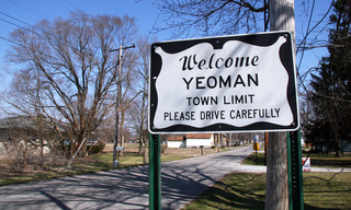
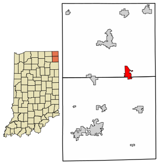
Yeoman is a town in Jefferson Township, Carroll County, Indiana, United States. The population was 139 at the 2010 census. It is part of the Lafayette, Indiana Metropolitan Statistical Area.

<span class="mw-page-title-main">Alfordsville, Indiana</span> Town in Indiana, United States

Alfordsville is a town in Reeve Township, Daviess County, Indiana, United States. The population was 101 at the 2010 census.

<span class="mw-page-title-main">Hamilton, Indiana</span> Town in Indiana, United States

Hamilton is a town located on the border of Steuben County, Indiana and DeKalb County, Indiana. In Steuben County, it is in Otsego Township, and in DeKalb County it is in Franklin Township. The population was 1,532 at the 2010 census.

<span class="mw-page-title-main">Newberry, Indiana</span> Town in Indiana, United States

Newberry is a town in Cass Township, Greene County, Indiana, United States. The population was 193 at the 2010 census. It is part of the Bloomington, Indiana Metropolitan Statistical Area.

<span class="mw-page-title-main">Cadiz, Indiana</span> Town in Indiana, United States

Cadiz is a town in Harrison Township, Henry County, Indiana, United States. The population was 150 at the 2010 census.

<span class="mw-page-title-main">Kennard, Indiana</span> Town in Indiana, United States

Kennard is a town in Greensboro Township, Henry County, Indiana, United States. The population was 471 at the 2010 census.

<span class="mw-page-title-main">Bicknell, Indiana</span> City in Indiana, United States

Bicknell is a city in Knox County, Indiana, United States. The population was 2,915 at the 2010 census.

<span class="mw-page-title-main">Etna Green, Indiana</span> Town in Indiana, United States

Etna Green is a town in Etna Township, Kosciusko County, in the U.S. state of Indiana. The population was 586 at the 2010 census.

<span class="mw-page-title-main">Pierceton, Indiana</span> Town in Indiana, United States

Pierceton is a town in Washington Township, Kosciusko County, in the U.S. state of Indiana. The population was 928 at the 2020 census.

<span class="mw-page-title-main">Sidney, Indiana</span> Town in Indiana, United States

Sidney is a town in Jackson Township, Kosciusko County, in the U.S. state of Indiana. The population was 83 at the 2010 census.

<span class="mw-page-title-main">Bremen, Indiana</span> Town in Indiana, United States

Bremen is a town in German Township, Marshall County, Indiana, United States. The population was 4,696 at the 2020 census.

<span class="mw-page-title-main">Morgantown, Indiana</span> Town in Indiana, United States

Morgantown is a town at the intersection of Indiana state routes 135 and 252 in Jackson Township, Morgan County, in the U.S. state of Indiana. The population was 1,014 at the 2020 census.

<span class="mw-page-title-main">Avilla, Indiana</span> Town in Indiana, United States

Avilla is a town in Allen Township, Noble County, in the U.S. state of Indiana. The population was 2,401 at the 2010 census.

<span class="mw-page-title-main">Fremont, Indiana</span> Town in Indiana, United States

Fremont is a town in Fremont Township, Steuben County, in the U.S. state of Indiana. The population was 2,138 at the 2010 census.

<span class="mw-page-title-main">West College Corner, Indiana</span> Town in Indiana, United States

West College Corner is a town in Union Township, Union County, Indiana, United States. The population was 545 at the 2020 census. The town is bordered on the east by the state line with Ohio, directly bordering the village of College Corner, Ohio. The town's public school, part of the Union County–College Corner Joint School District, is bisected by the state line and is operated jointly with Ohio authorities.

<span class="mw-page-title-main">Dublin, Indiana</span> Town in Indiana, United States

Dublin is a town in Jackson Township, Wayne County, in the U.S. state of Indiana. The population was 679 at the 2020 census.

Lake Fremont Township is a township in Martin County, Minnesota, United States. The population was 175 at the 2000 census.

<span class="mw-page-title-main">Blacklick Township, Cambria County, Pennsylvania</span> Township in Pennsylvania, United States

Blacklick Township is a township in Cambria County, Pennsylvania, United States. The population was 1,880 at the 2020 census. It is part of the Johnstown, Pennsylvania Metropolitan Statistical Area.

<span class="mw-page-title-main">Canoe Township, Pennsylvania</span> Township in Pennsylvania, United States

Canoe Township is a township in Indiana County, Pennsylvania, United States. The population was 1,432 at the 2020 census, a decline from the figure of 1,505 tabulated in 2010. Canoe Township was formed from Montgomery Township in 1847. It was named after Canoe Creek, which was so called because its mouth on Mahoning Creek was traditionally the head of canoe navigation. The township includes the communities of Canoe Ridge, Juneau, Locust, Locust Lane, Robertsville, and Rossiter.

References

  1. "2020 U.S. Gazetteer Files". United States Census Bureau. Retrieved March 16, 2022.
  2. 1 2 3 "Feature ID 430243". Geographic Names Information System . United States Geological Survey . Retrieved June 30, 2014.
  3. 1 2 "FIPS55 Data: Indiana". FIPS55 Data. United States Geological Survey. February 23, 2006. Archived from the original on June 18, 2006. Retrieved June 30, 2014.
  4. Argos Sesquicentennial Souvenir Book, Argos Public Library.
  5. "National Register Information System". National Register of Historic Places . National Park Service. July 9, 2010.
  6. "US Gazetteer files: 2010, 2000, and 1990". United States Census Bureau. February 12, 2011. Retrieved April 23, 2011.
  7. "G001 - Geographic Identifiers - 2010 Census Summary File 1". United States Census Bureau. Archived from the original on February 13, 2020. Retrieved July 13, 2015.
  8. "Census of Population and Housing". Census.gov. Retrieved June 4, 2015.
  9. "U.S. Census website". United States Census Bureau . Retrieved December 11, 2012.
  10. "U.S. Census website". United States Census Bureau . Retrieved January 31, 2008.
  11. "Homepage". Argos Community Schools. Retrieved March 10, 2018.
  12. "Indiana public library directory" (PDF). Indiana State Library. Archived from the original (PDF) on February 18, 2017. Retrieved March 10, 2018.
  13. Darnall, Bruce A. (February 28, 2013). "Padres Pitcher Is Passionate About Faith, Family, Farming and Baseball". Athletes in Action. Archived from the original on September 23, 2015. Retrieved April 8, 2023.