Bourbon, Indiana

Last updated

Bourbon, Indiana
Bourbon-indiana-downtown.jpg
Bourbon downtown
Marshall County Indiana Incorporated and Unincorporated areas Bourbon Highlighted 1806760.svg
Location of Bourbon in Marshall County, Indiana.
Coordinates: 41°17′52″N86°7′1″W / 41.29778°N 86.11694°W / 41.29778; -86.11694
Country United States
State Indiana
County Marshall
Township Bourbon
Area
[1]
  Total1.16 sq mi (2.99 km2)
  Land1.15 sq mi (2.98 km2)
  Water0.00 sq mi (0.01 km2)
Elevation
843 ft (257 m)
Population
 (2020)
  Total1,698
  Density1,475.24/sq mi (569.51/km2)
Time zone UTC-5 (EST)
  Summer (DST) UTC-5 (EST)
ZIP code
46504
Area code 574
FIPS code 18-06760 [2]
GNIS feature ID0431382 [3]
Website bourbon-in.gov

Bourbon is a town in Bourbon Township, Marshall County, Indiana, United States. The population was 1,698 at the 2020 census.

Contents

History

The town of Bourbon was laid out in 1853 when it was certain the railroad would be extended to that point. [4] It took its name from Bourbon Township, which was named after Bourbon County, Kentucky, the former home of many of the early settlers. [5]

The Bourbon Community Building-Gymnasium was listed on the National Register of Historic Places in 2015. [6]

Geography

Bourbon from the east. Bourbon-indiana-from-above.jpg
Bourbon from the east.

Bourbon is located at 41°17′52″N86°7′1″W / 41.29778°N 86.11694°W / 41.29778; -86.11694 (41.297815, -86.116921). [7]

According to the 2010 census, Bourbon has a total area of 0.99 square miles (2.56 km2), all land. [8]

Demographics

Historical population
CensusPop.Note
1870 874
1880 1,05620.8%
1890 1,0640.8%
1900 1,18711.6%
1910 1,163−2.0%
1920 1,2598.3%
1930 1,193−5.2%
1940 1,145−4.0%
1950 1,40422.6%
1960 1,5228.4%
1970 1,6065.5%
1980 1,522−5.2%
1990 1,6729.9%
2000 1,6911.1%
2010 1,8107.0%
2020 1,698−6.2%
U.S. Decennial Census [9]
Bourbon municipal offices building. Bourbon-indiana-town-hall.jpg
Bourbon municipal offices building.

2020 census

As of the census [10] of 2020, there were 1,698 people, 678 households, and 465 families living in the town. The population density was 1,828.3 inhabitants per square mile (705.9/km2). There were 753 housing units at an average density of 760.6 per square mile (293.7/km2). The racial makeup of the town was 96.7% White, 0.3% African American, 0.1% Native American, 0.6% Asian, 1.2% from other races, and 1.0% from two or more races. Hispanic or Latino of any race were 5.0% of the population.

There were 678 households, of which 38.8% had children under the age of 18 living with them, 49.1% were married couples living together, 14.5% had a female householder with no husband present, 5.0% had a male householder with no wife present, and 31.4% were non-families. 26.8% of all households were made up of individuals, and 10% had someone living alone who was 65 years of age or older. The average household size was 2.67 and the average family size was 3.25.

The median age in the town was 32.7 years. 30.8% of residents were under the age of 18; 8% were between the ages of 18 and 24; 26.6% were from 25 to 44; 23.8% were from 45 to 64; and 10.9% were 65 years of age or older. The gender makeup of the town was 48.6% male and 51.4% female.

2000 census

As of the census [2] of 2000, there were 1,691 people, 646 households, and 443 families living in the town. The population density was 1,630.3 inhabitants per square mile (629.5/km2). There were 702 housing units at an average density of 676.8 per square mile (261.3/km2). The racial makeup of the town was 96.16% White, 0.06% African American, 0.24% Native American, 0.59% Asian, 0.18% Pacific Islander, 2.37% from other races, and 0.41% from two or more races. Hispanic or Latino of any race were 5.03% of the population.

There were 646 households, out of which 38.1% had children under the age of 18 living with them, 54.8% were married couples living together, 9.4% had a female householder with no husband present, and 31.4% were non-families. 28.6% of all households were made up of individuals, and 12.2% had someone living alone who was 65 years of age or older. The average household size was 2.62 and the average family size was 3.26.

In the town, the population was spread out, with 31.3% under the age of 18, 9.5% from 18 to 24, 31.3% from 25 to 44, 16.2% from 45 to 64, and 11.7% who were 65 years of age or older. The median age was 32 years. For every 100 females, there were 92.8 males. For every 100 females age 18 and over, there were 89.6 males.

The median income for a household in the town was $40,292, and the median income for a family was $50,000. Males had a median income of $32,679 versus $21,645 for females. The per capita income for the town was $17,054. About 4.1% of families and 5.9% of the population were below the poverty line, including 8.0% of those under age 18 and 8.4% of those age 65 or over.

Education

The town has a lending library, the Bourbon Public Library. [11]

Triton School Corporation is headquartered in Bourbon, along with Triton Elementary and Jr./Sr. high schools, encompassing grades kindergarten through 12.

Bourbon Christian School is located on the north end of the town and encompasses grades 1 through 12.

See also

Related Research Articles

<span class="mw-page-title-main">Castleberry, Alabama</span> Town in Alabama, United States

Castleberry is a town in Conecuh County, Alabama, United States. At the 2020 census, the population was 486. Castleberry is known as the "Strawberry Capital of Alabama" and is home to the annual Castleberry Strawberry Festival. Castleberry is also known for its "speed trap" with the confiscation of property happening on a regular basis. The town has five police officers. A lawsuit against former Police Chief Tracy Hawsey and the town of Castleberry is pending. According to one source, "Lawsuits allege that Brookside police officers made up charges to soak vehicle owners for thousands of dollars in fines."

<span class="mw-page-title-main">Margaret, Alabama</span> City in Alabama, United States

Margaret is a city in St. Clair County, Alabama, United States. At the 2020 census, the population was 5,106. As of the 2010 census, the population is 4,428, an increase of 278.8%. Margaret incorporated in 1960 and became a city in October 2011.

<span class="mw-page-title-main">Bascom, Florida</span> Town in Florida, United States

Bascom is a town in Jackson County, Florida, United States. The town is located on the Florida Panhandle in North Florida, and is 5 miles (8 km) south of the Alabama border. The population was 121 at the 2020 census.

<span class="mw-page-title-main">Monroe, Adams County, Indiana</span> Town in Indiana, United States

Monroe is a town in Washington and Monroe townships, Adams County, Indiana, United States. The population of the town was 945 residents at the 2019 census. Adams Central Community Schools is located in Monroe.

<span class="mw-page-title-main">Grabill, Indiana</span> Town in Indiana, United States

Grabill is a town in Cedar Creek Township, Allen County, Indiana, United States. The population was 1,053 at the 2010 census. Today it is known for the presence of antique stores and Amish farms. An incorporated town, Grabill has two community parks within the corporate limits.

<span class="mw-page-title-main">Clifford, Indiana</span> Town in Indiana, United States

Clifford is a town in Flat Rock Township, Bartholomew County, Indiana, United States. The population was 233 at the 2010 census. It is part of the Columbus, Indiana metropolitan statistical area.

<span class="mw-page-title-main">Milltown, Indiana</span> Town in Indiana, United States

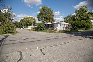
Milltown is a town in Whiskey Run Township in Crawford County, Indiana and in Blue River and Spencer townships in Harrison County. The population was 818 at the time of the 2010 census.

<span class="mw-page-title-main">Altona, Indiana</span> Town in Indiana, United States

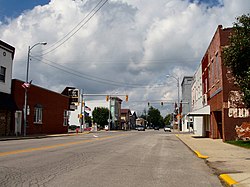
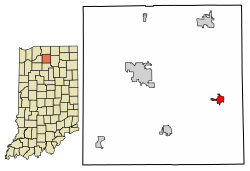
Altona is a town in Keyser Township, DeKalb County, Indiana, United States. The population was 197 at the 2010 census.

<span class="mw-page-title-main">Bargersville, Indiana</span> Town in Indiana, United States

Bargersville is a town in White River and Union townships, Johnson County, Indiana, United States. The population was 9,560 at the 2020 census.

<span class="mw-page-title-main">Bremen, Indiana</span> Town in Indiana, United States

Bremen is a town in German Township, Marshall County, Indiana, United States. The population was 4,696 at the 2020 census.

<span class="mw-page-title-main">Clear Lake, Indiana</span> Town in Indiana, United States

Clear Lake is a town located in the northeast corner of Steuben County, Indiana, in Clear Lake Township. As such, is the northeasternmost community in the State of Indiana. The population was 339 at the 2010 census.

<span class="mw-page-title-main">Livonia, Indiana</span> Town in Indiana, United States

Livonia is a town in Madison Township, Washington County, in the U.S. state of Indiana. The population was 128 at the 2010 census.

<span class="mw-page-title-main">Poneto, Indiana</span> Town in Indiana, United States

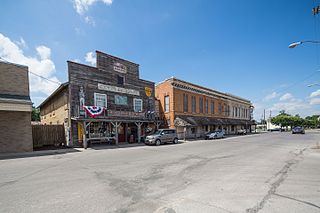
Poneto is a town in Chester, Harrison and Liberty townships, Wells County, in the U.S. state of Indiana. The population was 166 at the 2010 census.

<span class="mw-page-title-main">Freedom, Maine</span> Town in the state of Maine, United States

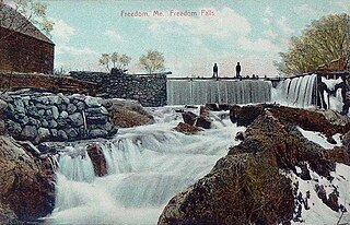
Freedom is a town in Waldo County, Maine, United States. The population was 711 at the 2020 census. Freedom is a residential and recreational area.

<span class="mw-page-title-main">Conneaut Lakeshore, Pennsylvania</span> Census-designated place in Pennsylvania, United States

Conneaut Lakeshore is a census-designated place (CDP) in Crawford County, Pennsylvania, United States. The population was 2,395 at the 2010 census.

<span class="mw-page-title-main">East Sumter, South Carolina</span> CDP in South Carolina, United States

East Sumter is a census-designated place (CDP) in Sumter County, South Carolina, United States. The population was 1,220 at the 2000 census. It is included in the Sumter, South Carolina Metropolitan Statistical Area.

<span class="mw-page-title-main">North Bend, Wisconsin</span> Town in Wisconsin, United States

North Bend is a town in Jackson County, Wisconsin, United States. The population was 397 at the 2000 census. The unincorporated communities of Buckholz Corners and North Bend are located in the town.

<span class="mw-page-title-main">Sinclair, Wyoming</span> Town in Wyoming, United States

Sinclair is a town in Carbon County, Wyoming, United States.

<span class="mw-page-title-main">Zwingle, Iowa</span> City in Iowa, United States

Zwingle is a city in Dubuque and Jackson counties in the U.S. state of Iowa. The population was 84 at the time of the 2020 census, down from 100 in 2000.

<span class="mw-page-title-main">Wynnedale, Indiana</span> Town in Indiana, United States

Wynnedale is a town in Washington Township, Marion County, Indiana, United States. The population was 215 at the 2020 census. It has existed as an "included town" since 1970, when it was incorporated into Indianapolis as part of Unigov. It is part of Indianapolis, but retains a functioning town government under IC 36-3-1-11.

References

  1. "2020 U.S. Gazetteer Files". United States Census Bureau. Retrieved March 16, 2022.
  2. 1 2 "U.S. Census website". United States Census Bureau . Retrieved January 31, 2008.
  3. "US Board on Geographic Names". United States Geological Survey. October 25, 2007. Retrieved January 31, 2008.
  4. "In The Beginning". Town of Bourbon, Indiana. Archived from the original on July 14, 2014. Retrieved July 11, 2014.
  5. McDonald, Daniel (1908). A Twentieth Century History of Marshall County, Indiana, Volume 1. Lewis Publishing Company. p. 114.
  6. "National Register of Historic Places Listings". Weekly List of Actions Taken on Properties: 12/14/15 through 12/18/15. National Park Service. December 24, 2015.
  7. "US Gazetteer files: 2010, 2000, and 1990". United States Census Bureau. February 12, 2011. Retrieved April 23, 2011.
  8. "G001 - Geographic Identifiers - 2010 Census Summary File 1". United States Census Bureau. Archived from the original on February 13, 2020. Retrieved July 13, 2015.
  9. "Census of Population and Housing". Census.gov. Retrieved June 4, 2015.
  10. "U.S. Census website". United States Census Bureau . Retrieved December 11, 2012.
  11. "Indiana public library directory" (PDF). Indiana State Library. Archived from the original (PDF) on February 18, 2017. Retrieved March 10, 2018.