Salamonia, Indiana

Last updated

Salamonia, Indiana
Salamonia, Indiana.jpg
Jay County Indiana Incorporated and Unincorporated areas Salamonia Highlighted 1867302.svg
Location of Salamonia in Jay County, Indiana.
Coordinates: 40°23′09″N84°51′54″W / 40.38583°N 84.86500°W / 40.38583; -84.86500
Country United States
State Indiana
County Jay
Township Madison
Area
[1]
  Total0.73 sq mi (1.90 km2)
  Land0.73 sq mi (1.90 km2)
  Water0.00 sq mi (0.00 km2)
Elevation
[2]
968 ft (295 m)
Population
 (2020)
  Total151
  Density206.00/sq mi (79.54/km2)
Time zone UTC-5 (Eastern (EST))
  Summer (DST) UTC-4 (EDT)
ZIP code
47381
Area code 260
FIPS code 18-67302 [3]
GNIS feature ID2396902 [2]

Salamonia is a town in Madison Township, Jay County, Indiana, United States. The population was 157 at the 2010 census. The town is situated along the Salamonie River, near its headwaters in Northern Indiana. [4]

Contents

History

Salamonia was originally called Lancaster, and under the latter name was platted in 1839. When the first post office was established there, it was discovered there was another Lancaster, Indiana, and the town was renamed Salamonia, in order to avoid repetition. [5] Salamonia was incorporated as a town in 1867. [6]

Geography

According to the 2010 census, Salamonia has a total area of 0.37 square miles (0.96 km2), all land. [7]

Demographics

Historical population
CensusPop.Note
1880 133
1890 15012.8%
1900 16812.0%
1910 1690.6%
1920 19414.8%
1930 180−7.2%
1940 1916.1%
1950 181−5.2%
1960 142−21.5%
1970 16214.1%
1980 147−9.3%
1990 138−6.1%
2000 15814.5%
2010 157−0.6%
2020 151−3.8%
U.S. Decennial Census [8]

2010 census

As of the census [9] of 2010, there were 157 people, 52 households, and 40 families living in the town. The population density was 424.3 inhabitants per square mile (163.8/km2). There were 61 housing units at an average density of 164.9 per square mile (63.7/km2). The racial makeup of the town was 98.7% White, 0.6% Native American, and 0.6% from two or more races. Hispanic or Latino of any race were 0.6% of the population.

There were 52 households, of which 42.3% had children under the age of 18 living with them, 61.5% were married couples living together, 13.5% had a female householder with no husband present, 1.9% had a male householder with no wife present, and 23.1% were non-families. 19.2% of all households were made up of individuals, and 5.8% had someone living alone who was 65 years of age or older. The average household size was 3.02 and the average family size was 3.50.

The median age in the town was 30.5 years. 33.8% of residents were under the age of 18; 9% were between the ages of 18 and 24; 22.9% were from 25 to 44; 26.8% were from 45 to 64; and 7.6% were 65 years of age or older. The gender makeup of the town was 49.7% male and 50.3% female.

2000 census

As of the census [3] of 2000, there were 158 people, 57 households, and 47 families living in the town. The population density was 429.9 inhabitants per square mile (166.0/km2). There were 58 housing units at an average density of 157.8 per square mile (60.9/km2). The racial makeup of the town was 98.73% White, 0.63% Asian, and 0.63% from two or more races. Hispanic or Latino of any race were 0.63% of the population.

There were 57 households, out of which 43.9% had children under the age of 18 living with them, 71.9% were married couples living together, 10.5% had a female householder with no husband present, and 15.8% were non-families. 14.0% of all households were made up of individuals, and 7.0% had someone living alone who was 65 years of age or older. The average household size was 2.77 and the average family size was 3.04.

In the town, the population was spread out, with 31.6% under the age of 18, 7.0% from 18 to 24, 29.7% from 25 to 44, 26.6% from 45 to 64, and 5.1% who were 65 years of age or older. The median age was 35 years. For every 100 females, there were 95.1 males. For every 100 females age 18 and over, there were 92.9 males.

The median income for a household in the town was $36,458, and the median income for a family was $46,250. Males had a median income of $30,313 versus $25,313 for females. The per capita income for the town was $11,734. About 16.2% of families and 16.1% of the population were below the poverty line, including 28.8% of those under the age of eighteen and 66.7% of those 65 or over.

Related Research Articles

<span class="mw-page-title-main">Monroe, Adams County, Indiana</span> Town in Indiana, United States

Monroe is a town in Washington and Monroe townships, Adams County, Indiana, United States. The population of the town was 945 residents at the 2019 census. Adams Central Community Schools is located in Monroe.

<span class="mw-page-title-main">Utica, Indiana</span> Town in Indiana, United States

Utica is a town in Utica Township, Clark County, Indiana, United States. The population was 776 at the 2010 census.

<span class="mw-page-title-main">Center Point, Indiana</span> Town in Indiana, United States

Center Point is a town in Sugar Ridge Township, Clay County, Indiana, United States. The population was 242 at the 2010 census. It is part of the Terre Haute Metropolitan Statistical Area.

<span class="mw-page-title-main">Wilkinson, Indiana</span> Town in Indiana, United States

Wilkinson is a town in Brown Township, Hancock County, Indiana, United States. The population was 449 at the 2010 census.

<span class="mw-page-title-main">Coatesville, Indiana</span> Town in Indiana, United States

Coatesville is a town in Clay Township, Hendricks County, Indiana, United States. The population was 523 at the 2010 Census.

<span class="mw-page-title-main">Bryant, Indiana</span> Town in Indiana, United States

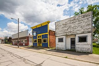
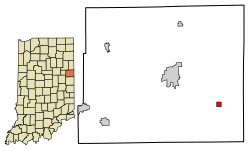
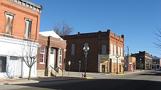
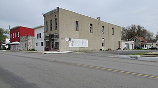
Bryant is a town in Bearcreek Township, Jay County, Indiana, United States. The population was 252 at the 2010 census.

<span class="mw-page-title-main">Redkey, Indiana</span> Town in Indiana, United States

Redkey is a town in Richland Township, Jay County, Indiana, United States. The population was 1,353 at the 2010 census.

<span class="mw-page-title-main">Prince's Lakes, Indiana</span> Town in Indiana, United States

Prince's Lakes is a town in Nineveh Township, Johnson County, Indiana, United States. The population was 1,312 at the 2010 census.

<span class="mw-page-title-main">Sidney, Indiana</span> Town in Indiana, United States

Sidney is a town in Jackson Township, Kosciusko County, in the U.S. state of Indiana. The population was 83 at the 2010 census.

<span class="mw-page-title-main">Topeka, Indiana</span> Town in Indiana, United States

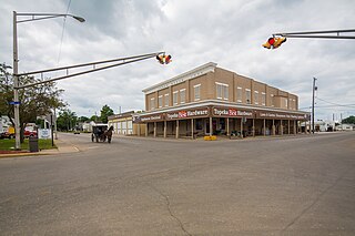
Topeka is a town in Clearspring and Eden townships, LaGrange County, Indiana, United States. The population was 1,153 at the 2010 census. Topeka is located approximately eleven miles south of Shipshewana, Indiana.

<span class="mw-page-title-main">Kingsbury, Indiana</span> Town in Indiana, United States

Kingsbury is a town in Washington Township, LaPorte County, Indiana, just northwest of the intersection of U.S. Route 35 and U.S. Route 6. The town was founded in 1835 and incorporated on March 3, 1941. During 1940 - 1941, the Kingsbury Ordnance Plant (KOP) was built for use during World War II. The plant closed after the war but reopened during the Korean War, closing permanently in 1959. The population was 242 at the 2010 census. It is included in the Michigan City, Indiana-La Porte, Indiana Metropolitan Statistical Area. The town has its own fire department, KVFD, and a Greek revival style First Baptist church built in 1851 with its own graveyard and Winchell Cemetery.

<span class="mw-page-title-main">Edgewood, Indiana</span> Town in Indiana, United States

Edgewood is a town in Anderson Township, Madison County, Indiana, United States. It is part of the Indianapolis–Carmel–Anderson metropolitan statistical area. The population was 2,053 at the 2020 census.

<span class="mw-page-title-main">Ingalls, Indiana</span> Town in Indiana, United States

Ingalls is a town in Green Township, Madison County, Indiana, United States. It is part of the Indianapolis–Carmel–Anderson metropolitan statistical area. The population was 2,223 at the 2020 census.

<span class="mw-page-title-main">Winslow, Indiana</span> Town in Indiana, United States

Winslow is a town in Patoka Township, Pike County, in the U.S. state of Indiana. The population was 864 at the 2010 census. It is part of the Jasper Micropolitan Statistical Area.

<span class="mw-page-title-main">Losantville, Indiana</span> Town in Indiana, United States

Losantville is a town in Union Township, Randolph County, in the U.S. state of Indiana. The population was 237 at the 2010 census.

<span class="mw-page-title-main">Modoc, Indiana</span> Town in Indiana, United States

Modoc is a town in Union Township, Randolph County, in the U.S. state of Indiana. The population was 196 at the 2010 census.

<span class="mw-page-title-main">Hudson, Indiana</span> Town in Indiana, United States

Hudson is a town in Salem and Steuben townships, Steuben County, in the U.S. state of Indiana. The population was 518 at the 2010 census.

<span class="mw-page-title-main">Whitewater, Indiana</span> Town in Indiana, United States

Whitewater is a town in Franklin Township, Wayne County, in the U.S. state of Indiana. The population was 83 at the 2010 census.

<span class="mw-page-title-main">Warren Park, Indiana</span> Town in Indiana, United States

Warren Park is a town in Warren Township, Marion County, Indiana, United States. The population was 1,490 at the 2020 census. It has existed as an "included town" since 1970, when it was incorporated into Indianapolis as part of Unigov. It is part of Indianapolis, but retains a functioning town government under IC 36-3-1-11.

<span class="mw-page-title-main">Williams Creek, Indiana</span> Town in Indiana, United States

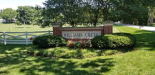
Williams Creek is a town in Washington Township, Marion County, Indiana, United States. It is located about 9 miles (14 km) north of downtown Indianapolis. The population was 430 at the 2020 census. It has existed as an "included town" since 1970, when it was incorporated into Indianapolis as part of Unigov. It is part of Indianapolis, but retains a functioning town government under IC 36-3-1-11.

References

  1. "2020 U.S. Gazetteer Files". United States Census Bureau. Retrieved March 16, 2022.
  2. 1 2 U.S. Geological Survey Geographic Names Information System: Salamonia, Indiana
  3. 1 2 "U.S. Census website". United States Census Bureau . Retrieved January 31, 2008.
  4. DeLorme (1998). Indiana Atlas & Gazetteer. Yarmouth, Maine: DeLorme. ISBN   0-89933-211-0
  5. Jay, Milton T. (1922). History of Jay County, Indiana: Including Its World War Record and Incorporating the Montgomery History, Volume 1. Historical Publishing Company. p. 252.
  6. "Incorporated Cities and Towns". Jay County Historical Society. Archived from the original on May 29, 2014. Retrieved May 28, 2014.
  7. "G001 - Geographic Identifiers - 2010 Census Summary File 1". United States Census Bureau. Archived from the original on February 13, 2020. Retrieved July 25, 2015.
  8. "Census of Population and Housing". Census.gov. Retrieved June 4, 2015.
  9. "U.S. Census website". United States Census Bureau . Retrieved December 11, 2012.