
Oceola is a census-designated place (CDP) in central Tod Township, Crawford County, Ohio, United States. As of the 2020 census its population was 156. It has a post office with the ZIP code 44860. It is located along the road that was U.S. Route 30 until being upgraded to a freeway.
Miamiville is an unincorporated community and census-designated place (CDP) in western Miami Township, Clermont County, Ohio, United States, along the Little Miami River and the Loveland Bike Trail. It had a population of 205 at the 2020 census. It has a post office with the ZIP code 45147.

Rockbridge is an unincorporated community and census-designated place (CDP) in eastern Good Hope Township, Hocking County, Ohio, United States. It has a post office with the ZIP code 43149. It is located at the interchange of U.S. Route 33 and State Route 374, between Logan and Lancaster. As of the 2020 census the population of the CDP was 160.

Haydenville is an unincorporated community and census-designated place (CDP) in southern Green Township, Hocking County, Ohio, United States. As of the 2020 census the population of the CDP was 337.

Miamitown is a census-designated place (CDP) in western Whitewater Township, Hamilton County, Ohio, United States. The population was 1,256 at the 2020 census. It has a post office with the ZIP code 45041.
Camp Dennison is a census-designated place (CDP) just outside Indian Hill in southern Symmes Township, Hamilton County, Ohio, United States. It has a post office with the ZIP code 45111. The population was 384 at the 2020 census.

Stewart is an unincorporated community and census-designated place in central Rome Township, Athens County, Ohio, United States. The population was 221 at the 2020 census. It has a post office with the ZIP code 45778.

New Marshfield is a census-designated place in central Waterloo Township, Athens County, Ohio, United States. The population was 316 at the 2020 census. It has a post office with the ZIP code 45766. It is located along State Route 56 west of the county seat of Athens.

Millfield is a census-designated place in northern Dover Township, Athens County, Ohio, United States. It had a population of 311 at the 2020 census. It has a post office with the ZIP code 45761. It is located near State Route 13 midway between Chauncey and Jacksonville. Route 13 formerly ran through the community, but a bypass relocated it close by.

Hockingport is a census-designated place in southeastern Troy Township, Athens County, Ohio, United States. As of the 2020 census it had a population of 205. It has a post office with the ZIP code 45739. It is located at the intersection of State Routes 124 and 144.

Dundee is a census-designated place in central Wayne Township, Tuscarawas County, Ohio, United States. It has a post office with the ZIP code 44624. It lies at the intersection of State Routes 93 and 516. The population was 269 at the 2020 census.
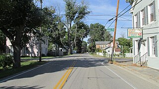
Robertsville is an unincorporated community and census-designated place in western Paris Township, Stark County, Ohio, United States. It has a post office with the ZIP code 44670. It lies along U.S. Route 30 between East Canton and Minerva and is in the Minerva Local School District. The community is part of the Canton–Massillon Metropolitan Statistical Area. The population was 293 at the 2020 census.

Friendship is a census-designated place in western Nile Township, Scioto County, Ohio, United States. As of the 2020 census it had a population of 343. It has a post office with the ZIP code 45630. It lies along U.S. Route 52.
Vincent is a census-designated place in southern Barlow Township, Washington County, Ohio, United States. It lies along State Route 339 near Tupper Creek, a subsidiary of the Little Hocking River, which in turn meets the Ohio River at Little Hocking to the south. The population was 329 at the 2020 census.

Reno is a census-designated place in southern Marietta Township, Washington County, Ohio, United States. It has a post office with the ZIP code 45773. It is located on the Ohio River a short distance south of the county seat of Marietta. State Route 7 forms its main street. The population was 1,129 at the 2020 census.

Newport is a census-designated place in eastern Newport Township, Washington County, Ohio, United States. It has a post office with the ZIP code 45768. Newport lies along the Ohio River several miles above the county seat of Marietta. Today its main street is designated as State Route 7. The population of the CPD was 895 at the 2020 census.

Cutler is an unincorporated community in southwestern Fairfield Township, Washington County, Ohio, United States. It has a post office with the ZIP code 45724. It lies at the intersection of State Route 555 and County Road 59 near Gilbert Run, a subsidiary of the Little Hocking River, which meets the Ohio River at Little Hocking to the southeast.

Richmond Dale is a census-designated place in central Jefferson Township, Ross County, Ohio, United States. It has a post office with the ZIP code 45673. It is located along U.S. Route 35 southeast of the county seat of Chillicothe. The population of the CPD was 386 at the 2020 census.

Bourneville is a census-designated place in central Twin Township, Ross County, Ohio, United States. It has a post office with the ZIP code 45617. It lies along U.S. Route 50. The population of the CPD was 241 at the 2020 census.

East Fultonham is a census-designated place in central Newton Township, Muskingum County, Ohio, United States. It has a post office with the ZIP code 43735. It is located along U.S. Route 22 a short distance east of the village of Fultonham. The population was 290 at the 2020 census.

