Arlington is an unincorporated community in Posey Township, in the northwestern part of Rush County, Indiana, United States. It lies just south of the B&O Railroad, on U.S. Route 52, 8 miles west of Rushville.

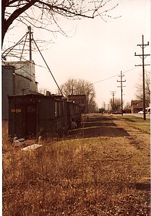
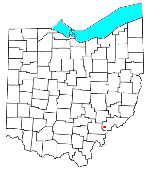
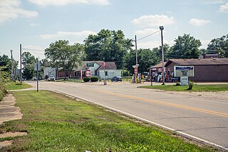
Damascus is an unincorporated community and census-designated place in southern Mahoning and northern Columbiana counties in the U.S. state of Ohio. As of the 2020 census, it had a population of 418. The community lies at the intersection of U.S. Route 62 and State Routes 173 and 534.
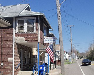
Kensington is an unincorporated community in southwestern Hanover Township, Columbiana County, Ohio, United States. Lying along U.S. Route 30 at its intersection with Ohio State Routes 9 and 644, it has a post office with the ZIP code 44427. Kensington is a part of the Salem micropolitan area, 23 miles (37 km) miles east of Canton and 30 miles (48 km) southwest of Youngstown.

Wingett Run is an unincorporated community in western Ludlow Township, Washington County, Ohio, United States. It has a post office with the ZIP code 45789. It is located along State Route 26 and the Little Muskingum River.
Cutler is an unincorporated community in southwestern Fairfield Township, Washington County, Ohio, United States. It has a post office with the ZIP code 45724. It lies at the intersection of State Route 555 and County Road 59 near Gilbert Run, a subsidiary of the Little Hocking River, which meets the Ohio River at Little Hocking to the southeast.
Mays is an unincorporated community in Center Township, Rush County, in the U.S. state of Indiana.

St. Croix or Saint Croix is an unincorporated community in northern Oil Township, Perry County, in the U.S. state of Indiana.
Richland is an unincorporated community in western Richland Township, Rush County, Indiana, United States. It lies along State Road 244, south of the city of Rushville, the county seat of Rush County.

Patricksburg is an unincorporated community in eastern Marion Township, Owen County, in the U.S. state of Indiana. It lies along State Road 246, west of the city of Spencer, the county seat of Owen County. Its elevation is 715 feet (218 m), and it is located at 39°18′56″N86°57′33″W. Although Patricksburg is unincorporated, it has a post office, with the ZIP code of 47455.

Quincy is an unincorporated community in northeastern Taylor Township, Owen County, in the U.S. state of Indiana. It lies just south of CR1150N, north of the town of Spencer, the county seat of Owen County. Its elevation is 738 feet (225 m), and it is located at 39°27′13″N86°42′45″W. Although Quincy is unincorporated, it has a post office, with the ZIP code of 47456.
Prairie Creek is an unincorporated community in southeastern Prairie Creek Township, Vigo County, in the U.S. state of Indiana. Its elevation is 528 feet (161 m), and it is located at 39°16′30″N87°29′50″W. Because the community has had multiple names, the Board on Geographic Names officially decided in favor of "Prairie Creek" in 1959. Although Prairie Creek is unincorporated, it has a post office, with the ZIP code of 47869.
Paris Crossing is an unincorporated community in southern Montgomery Township, Jennings County, Indiana, United States. It lies along State Road 250, south of the town of Vernon, the county seat of Jennings County. Although Paris Crossing is unincorporated, it has a post office, with the ZIP code of 47270.

Norman is an unincorporated community in northwestern Owen Township, Jackson County, Indiana, United States. It lies along State Road 58 northwest of the town of Brownstown, the county seat of Jackson County. Because the community had two different names, the Board on Geographic Names officially decided in favor of "Norman" in 1943. Although Norman is unincorporated, it has a post office, with the ZIP code of 47264.
Falmouth is an unincorporated community in Fayette and Rush counties in the U.S. state of Indiana. Located at the northeastern corner of Union Township and the southeastern corner of Washington Township in Rush County and along the northwestern edge of Fairview Township in Fayette County, it lies at the intersection of CR800E with CR600N /CR400N(Fayette County). Falmouth sits northwest of Connersville and northeast of Rushville, the county seats of Fayette and Rush counties respectively. Although Falmouth is unincorporated, it has a post office, with the ZIP code of 46127.

Derby is an unincorporated community along the Ohio River in far southern Union Township, Perry County, in the U.S. state of Indiana. It lies at the intersection of State Roads 66 and 70 above the city of Tell City, the county seat of Perry County. Although Derby is unincorporated, it has a post office, with the ZIP code of 47525.
Cortland is an unincorporated community in eastern Hamilton Township, Jackson County, Indiana, United States. It lies along State Road 258, northwest of the city of Seymour. Although Cortland is unincorporated, it has a post office, with the ZIP code of 47228.

Butlerville is an unincorporated community and census-designated place (CDP) in central Campbell Township, Jennings County, Indiana, United States. As of the 2010 census it had a population of 282.
Bennington is an unincorporated community in central Pleasant Township, Switzerland County, in the U.S. state of Indiana. Although Bennington is unincorporated, it has a post office, with the ZIP code of 47011.
Ozark is an unincorporated community in Johnson County, Illinois, United States. Ozark is south of New Burnside. and has a post office with ZIP code 62972. Ozark is also home to Camp Ondessonk, a Catholic youth camp that is run by the Diocese of Belleville.
Mary Marjorie Pebworth was an American politician.