
Carroll County is a county located in the U.S. state of Indiana. As of the 2020 United States Census, the population was 20,306. The county seat is Delphi.

Corydon is a town in Harrison Township, Harrison County, Indiana. Located north of the Ohio River in the extreme southern part of the U.S. state of Indiana, it is the seat of government for Harrison County. Corydon was founded in 1808 and served as the capital of the Indiana Territory from 1813 to 1816. It was the site of Indiana's first constitutional convention, which was held June 10–29, 1816. Forty-three delegates convened to consider statehood for Indiana and drafted its first state constitution. Under Article XI, Section 11, of the Indiana 1816 constitution, Corydon was designated as the capital of the state, which it remained until 1825, when the seat of state government was moved to Indianapolis. In 1863, during the American Civil War, Corydon was the site of the Battle of Corydon, the only official pitched battle waged in Indiana during the war. More recently, the town's numerous historic sites have helped it become a tourist destination. A portion of its downtown area is listed in the National Register of Historic Places as the Corydon Historic District. As of the 2010 census, Corydon had a population of 3,122.

Knightstown is a town in Wayne Township, Henry County, Indiana, adjacent to Rush County, along the Big Blue River. The population was 2,182 at the 2010 census. It is approximately thirty-two miles east of Indianapolis.

Farmland is a town in Monroe Township, Randolph County, in the U.S. state of Indiana. The population was 1,333 at the 2010 census.
Vevay is a town located in Jefferson Township and the county seat of Switzerland County, Indiana, United States, along the Ohio River. The population was 1,683 at the 2010 census.

Monon is a town in Monon Township, White County, in the U.S. state of Indiana. The population was 1,777 at the 2010 census.
Adams Township is one of fourteen townships in Carroll County, Indiana. As of the 2010 census, its population was 516 and it contained 209 housing units.

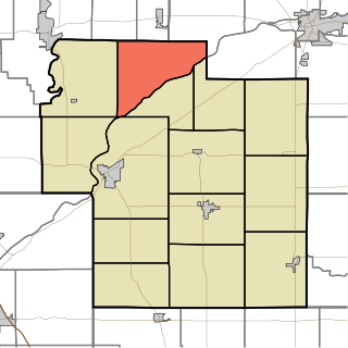
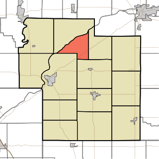
Deer Creek Township is one of fourteen townships in Carroll County, Indiana. As of the 2010 census, its population was 4,571 and it contained 1,970 housing units.
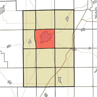
Rock Creek Township is one of fourteen townships in Carroll County, Indiana. As of the 2010 census, its population was 475 and it contained 185 housing units.

Tippecanoe Township is one of fourteen townships in Carroll County, Indiana. As of the 2010 census, its population was 2,341 and it contained 1,186 housing units.

Manchester Township is one of fourteen townships in Dearborn County, Indiana. As of the 2010 census, its population was 3,215 and it contained 1,233 housing units.
Huntington Township is one of twelve townships in Huntington County, Indiana. As of the 2020 census, its population was 20,326, making it the most populous township in the county.

Burnsville is an unincorporated community in Rock Creek Township, Bartholomew County, in the U.S. state of Indiana.

Scotland is an unincorporated community and census-designated place (CDP) in Taylor Township, Greene County, Indiana, United States. As of the 2010 census it had a population of 134.

Freetown is an unincorporated community and census-designated place in Pershing Township, Jackson County, Indiana, United States. As of the 2010 census the population was 385.

Avoca is an unincorporated community and census-designated place in Marshall Township, Lawrence County, Indiana, United States. As of the 2010 census the population was 583.

Lee is an unincorporated community in Monon Township, White County, in the U.S. state of Indiana.

Trinity Springs is an unincorporated community in Mitcheltree Township, Martin County, in the U.S. state of Indiana.
Deer Creek is an unincorporated town in Carroll County, Indiana, in the United States. It is tracked by the United States Census as a census-designated place.

District School No. 3, also known as Rock Creek Township School No. 3, Election School, and Martin School, is a historic school building located in Rockfield, Indiana in Rock Creek Township, Carroll County, Indiana. It was built in 1874, and is a one-story, rectangular red brick building with Greek Revival and Italianate style design elements. It has a front gable roof and sits on a fieldstone foundation.


