
LaPorte County is a county located in the U.S. state of Indiana. As of 2010, the population was 111,467. The county seat is the city of La Porte, and the largest city is Michigan City. This county is part of the Northwest Indiana and Michiana regions of the Chicago metropolitan area. The LaPorte County Courthouse is located in the county seat of La Porte and is listed on the National Register of Historic Places.

Francisco is the fifth largest town and seventh largest community in Gibson County, Indiana, United States. A town in Center Township, the population was 469 at the 2010 census and was founded in 1851. Local tradition says the town was named for its first settler, a Spanish laborer working on the Wabash and Erie Canal who built a shack in the area. It is part of the Evansville, Indiana, Metropolitan Area.

Cambridge City is a town in Jackson Township, Wayne County, in the U.S. state of Indiana. The population was 1,870 at the 2010 census.

Port Leyden is a village in Lewis County, New York, United States. The population was 672 at the 2010 census. The name is derived from the village's early history as a port on the Black River Canal.
Cherry Tree is a borough in Indiana County, Pennsylvania, United States. The population was 364 at the 2010 census.

Saltsburg is a borough in Indiana County, Pennsylvania, United States. The population was 873 at the 2010 census. The town was based on the construction of salt wells and the canals and railroad tracks that passed through it. It is in western Pennsylvania.

Junction is a city in and the seat of Kimble County, Texas, United States. Its population was 2,574 at the 2010 census.

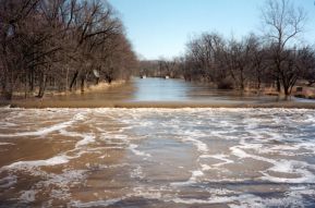
The Wabash and Erie Canal was a shipping canal that linked the Great Lakes to the Ohio River via an artificial waterway. The canal provided traders with access from the Great Lakes all the way to the Gulf of Mexico. Over 460 miles long, it was the longest canal ever built in North America.

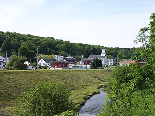
Metamora is an unincorporated town and census-designated place in Metamora Township, Franklin County, Indiana. The town was once a stop along the Whitewater Canal and is now primarily dependent on tourism. As of the 2010 census, it had a population of 188.

LaOtto is a small unincorporated community in Swan Township, Noble County, Indiana, in the U.S. state of Indiana. Located west of the current intersection of Indiana State Road 3 and Indiana State Road 205, it is 16 miles north of Fort Wayne and is also in proximity to Kendallville and Auburn. It is therefore considered a bedroom community to these cities.
Collamer is an unincorporated community in Cleveland Township, Whitley County, Indiana, United States, located on the Eel River and at the intersection of Indiana State Road 14 and Whitley County road 900 W. Smith Rambo platted the town February 9, 1846. Collamer is named after Jacob Collamer, 13th United States Postmaster General.

Jackson Township is one of twelve townships in Boone County, Indiana. As of the 2010 census, its population was 2,731 and it contained 1,089 housing units.

Harrison Township is one of eleven townships in Clay County, Indiana. As of the 2010 census, its population was 2,172 and it contained 1,040 housing units.

Jefferson Township is one of fifteen townships in Greene County, Indiana, USA. As of the 2010 census, its population was 2,094.

Eel Township is one of fourteen townships in Cass County, Indiana. As of the 2010 census, its population was 18,767.

Collins is an unincorporated community in Smith Township, Whitley County, in the U.S. state of Indiana. It is commonly referred to as a 'ghost town', however this is untrue; Collins just has a very low population and contains an abandoned school.

Adamsboro is an unincorporated community in Clay Township, Cass County, Indiana.

Scotland is an unincorporated community and census-designated place (CDP) in Taylor Township, Greene County, Indiana, United States. As of the 2010 census it had a population of 134.

Pettysville is an unincorporated community in Richland Township, Miami County, in the U.S. state of Indiana.

Rome is an unincorporated community along the Ohio River in southeastern Tobin Township, Perry County, in the U.S. state of Indiana.


