Owensburg, Indiana

Last updated

Owensburg, Indiana
Greene County Indiana Incorporated and Unincorporated areas Owensburg Highlighted 1857510.svg
Location of Owensburg in Greene County, Indiana.
USA Indiana location map.svg
Red pog.svg
Owensburg
Usa edcp location map.svg
Red pog.svg
Owensburg
Coordinates: 38°55′20″N86°44′40″W / 38.92222°N 86.74444°W / 38.92222; -86.74444
Country United States
State Indiana
County Greene
Township Jackson
Area
[1]
  Total5.93 sq mi (15.35 km2)
  Land5.92 sq mi (15.33 km2)
  Water0.01 sq mi (0.02 km2)
Elevation
[2]
643 ft (196 m)
Population
 (2020)
  Total402
  Density67.91/sq mi (26.22/km2)
ZIP code
47453
FIPS code 18-57510 [3]
GNIS feature ID2583463 [2]

Owensburg is an unincorporated community and census-designated place (CDP) in Jackson Township, Greene County, Indiana, United States. It was named in honor of the Owens family of early settlers. [4] As of the 2010 census it had a population of 406. [5]

Contents

Geography

Owensburg is located in southeastern Greene County. The southern border of the CDP follows the Martin County line, and the western edge of the CDP follows Indiana State Road 45. State Road 58 passes through the center of Owensburg, leading east 17 miles (27 km) to Bedford and west with State Road 45 11 miles (18 km) to Interstate 69 and U.S. Route 231 near Scotland. State Road 45 leads north from Owensburg 4 miles (6 km) to Interstate 69 and 25 miles (40 km) to Bloomington.

According to the U.S. Census Bureau, the Owensburg CDP has a total area of 5.9 square miles (15.4 km2), of which 0.01 square miles (0.02 km2), or 0.13%, is water. [5] The center of Owensburg is in the valley of Town Branch, which flows east to Indian Creek, a tributary of East Fork of the White River and part of the Wabash River watershed.

Demographics

Historical population
CensusPop.Note
2020 402
U.S. Decennial Census [6]

Related Research Articles

<span class="mw-page-title-main">Greene County, Indiana</span> County in Indiana, United States

Greene County is a county in the U.S. state of Indiana. As of 2020, the population was 30,803. The county seat is Bloomfield. The county was determined by the US Census Bureau to include the mean center of U.S. population in 1930.

<span class="mw-page-title-main">Roselawn, Indiana</span> Census-designated place in Indiana, United States

Roselawn is a census-designated place (CDP) in Newton and Jasper counties in the U.S. state of Indiana. The population was 4,131 at the 2010 census.

<span class="mw-page-title-main">Mexico, Indiana</span> Census-designated place in Indiana, United States

Mexico is an unincorporated community and census-designated place (CDP) in Jefferson Township, Miami County, in the U.S. state of Indiana. The population was 915 at the 2020 census.

Jefferson Heights is a hamlet and census-designated place (CDP) in Greene County, New York, United States. The population was 1,122 at the 2020 census.

Parker is a census-designated place (CDP) in Greenville County, South Carolina, United States. The population was 11,431 at the 2010 census, up from 10,760 in 2000. It is part of the Greenville–Mauldin–Easley Metropolitan Statistical Area.

<span class="mw-page-title-main">Lincolnia, Virginia</span> Census-designated place in Virginia, United States

Lincolnia is a census-designated place (CDP) in Fairfax County, Virginia, United States. The population was 22,828 at the 2010 census, an increase of over 44% from 2000.

<span class="mw-page-title-main">Glen Allen, Virginia</span> Census-designated place in Virginia

Glen Allen is a census-designated place (CDP) in Henrico County, Virginia, United States. The population was 16,187 as of the 2020 Census, up from 14,774 at the 2010 census. Areas outside the CDP which use a "Glen Allen" mailing address include residences in neighboring Hanover County.

<span class="mw-page-title-main">Riverpoint, Washington</span> Census-designated place in Washington, United States

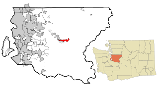
Riverpoint is an unincorporated community and census-designated place (CDP) in east King County, Washington, United States. As of the 2020 census, it had a population of 774. At the 2010 census, the area was listed as the Tanner CDP and had a population of 1,018 over a larger area.

Belmont is a census-designated place (CDP) in Loudoun County, Virginia, United States. The population as of the 2010 United States Census was 5,966. It is 5 miles (8 km) southeast of Leesburg, the Loudoun county seat, and 31 miles (50 km) northwest of Washington, D.C. The Belmont Manor House, built between 1799 and 1802 by a son of Richard Henry Lee, is in the northeast part of the CDP and is now the clubhouse for a gated golf community.

<span class="mw-page-title-main">Harrison Township, Clay County, Indiana</span> Township in Indiana, United States

Harrison Township is one of eleven townships in Clay County, Indiana. As of the 2010 census, its population was 2,172 and it contained 1,040 housing units.

<span class="mw-page-title-main">Scotland, Indiana</span> Census-designated place in Indiana, United States

Scotland is an unincorporated community and census-designated place (CDP) in Taylor Township, Greene County, Indiana, United States. As of the 2010 census it had a population of 134.

<span class="mw-page-title-main">Scipio, Indiana</span> Census-designated place in Indiana, United States

Scipio is an unincorporated community and census-designated place (CDP) in Geneva Township, Jennings County, Indiana, United States. As of the 2010 census it had a population of 153.

<span class="mw-page-title-main">Stanford, Indiana</span> Census-designated place in Indiana, United States

Stanford is an unincorporated community and census-designated place (CDP) in Van Buren Township, Monroe County, in the U.S. state of Indiana.

Waverly is an unincorporated community and census-designated place (CDP) in Harrison Township, Morgan County, in the U.S. state of Indiana.

<span class="mw-page-title-main">Clinton (CDP), Maine</span> Census-designated place in Maine, United States

Clinton is a census-designated place (CDP) and the primary village in the town of Clinton in Kennebec County, Maine, United States. The population was 1,419 at the 2010 census, out of 3,486 in the entire town of Clinton.

<span class="mw-page-title-main">Farmingdale (CDP), Maine</span> Census-designated place in Maine, United States

Farmingdale is a census-designated place (CDP) in the town of Farmingdale in Kennebec County, Maine, United States. The population was 1,970 at the 2010 census, out of 2,956 in the entire town.

<span class="mw-page-title-main">Oakland (CDP), Maine</span> Census-designated place in Maine, United States

Oakland is a census-designated place (CDP) comprising the main population center in the town of Oakland in Kennebec County, Maine, United States. The population was 2,602 at the 2010 census, out of 6,240 in the entire town of Oakland.

<span class="mw-page-title-main">Waldoboro (CDP), Maine</span> Census-designated place in Maine, United States

Waldoboro is a census-designated place (CDP) comprising the central village in the town of Waldoboro in Lincoln County, Maine, United States. The population was 1,300 at the 2020 census, out of 5,075 people in the entire town of Waldoboro.

<span class="mw-page-title-main">Wiscasset (CDP), Maine</span> Census-designated place in Maine, United States

Wiscasset is a census-designated place (CDP) comprising the primary settlement in the town of Wiscasset in Lincoln County, Maine, United States. The population was 1,232 at the 2020 census, out of 3,732 people in the entire town. Wiscasset is the county seat of Lincoln County.

<span class="mw-page-title-main">Landess, Indiana</span> Census-designated place in Indiana, United States

Landess is an unincorporated community and census-designated place (CDP) in Washington and Van Buren townships, Grant County, Indiana, in the United States. As of the 2010 census it had a population of 188.

References

  1. "2020 U.S. Gazetteer Files". United States Census Bureau. Retrieved March 16, 2022.
  2. 1 2 U.S. Geological Survey Geographic Names Information System: Owensburg, Indiana
  3. "U.S. Census website". United States Census Bureau . Retrieved January 31, 2008.
  4. Baker, Ronald L. (October 1995). From Needmore to Prosperity: Hoosier Place Names in Folklore and History . Indiana University Press. p.  254. ISBN   978-0-253-32866-3. ...named for the local Owens family.
  5. 1 2 "Geographic Identifiers: 2010 Demographic Profile Data (G001): Owensburg CDP, Indiana". American Factfinder. U.S. Census Bureau. Retrieved December 5, 2016.[ dead link ]
  6. "Census of Population and Housing". Census.gov. Retrieved June 4, 2016.