Alton, Indiana

Last updated

Alton, Indiana
Crawford County Indiana Incorporated and Unincorporated areas Alton Highlighted 1801270.svg
Location of Alton in Crawford County, Indiana.
Coordinates: 38°07′16″N86°25′10″W / 38.12111°N 86.41944°W / 38.12111; -86.41944
Country United States
State Indiana
County Crawford
Township Boone
Area
[1]
  Total0.20 sq mi (0.51 km2)
  Land0.17 sq mi (0.45 km2)
  Water0.03 sq mi (0.06 km2)
Elevation
[2]
407 ft (124 m)
Population
 (2020)
  Total29
  Density168.60/sq mi (65.11/km2)
Time zone UTC-5 (EST)
  Summer (DST) UTC-4 (EDT)
ZIP code
47137
Area code 812
FIPS code 18-01270
GNIS ID2397425 [2]

Alton is a town in Boone Township, Crawford County, Indiana, United States. The population was 29 at the 2020 census.

Contents

History

Alton was founded in 1838. [3]

Alton was called Nebraska in its early years. [4] The Nebraska post office opened in 1847, and was renamed Alton in 1860. [5] The post office in Alton was finally discontinued in 1965. [6]

Geography

According to the 2010 census, Alton has a total area of 0.19 square miles (0.49 km2), of which 0.17 square miles (0.44 km2) (or 89.47%) is land and 0.02 square miles (0.05 km2) (or 10.53%) is water. [7]

Demographics

Historical population
CensusPop.Note
1870 137
1880 25989.1%
1890 2776.9%
1900 238−14.1%
1910 161−32.4%
1920 128−20.5%
1930 109−14.8%
1940 78−28.4%
1950 71−9.0%
1960 57−19.7%
1970 56−1.8%
1980 6414.3%
1990 57−10.9%
2000 53−7.0%
2010 553.8%
2020 29−47.3%
US Decennial Census [8]

2010 census

As of the 2010 census, [9] there were 55 people, 25 households, and 19 families residing in the town. The population density was 323.5 inhabitants per square mile (124.9/km2). There were 55 housing units at an average density of 323.5 per square mile (124.9/km2). The racial makeup of the town was 96.4% White and 3.6% from other races. Hispanic or Latino of any race were 3.6% of the population.

There were 25 households, of which 24.0% had children under the age of 18 living with them, 52.0% were married couples living together, 12.0% had a female householder with no husband present, 12.0% had a male householder with no wife present, and 24.0% were non-families. 20.0% of all households were made up of individuals, and 4% had someone living alone who was 65 years of age or older. The average household size was 2.20 and the average family size was 2.37.

The median age in the town was 53.2 years. 10.9% of residents were under the age of 18; 11% were between the ages of 18 and 24; 14.6% were from 25 to 44; 40% were from 45 to 64; and 23.6% were 65 years of age or older. The gender makeup of the town was 56.4% male and 43.6% female.

2000 census

As of the 2000 census, [10] there were 53 people, 24 households, and 16 families residing in the town. The population density was 312.3 inhabitants per square mile (120.6/km2). There were 65 housing units at an average density of 383.0 per square mile (147.9/km2). The racial makeup of the town was 100.00% White.

There were 24 households, out of which 29.2% had children under the age of 18 living with them, 54.2% were married couples living together, 12.5% had a female householder with no husband present, and 33.3% were non-families. 29.2% of all households were made up of individuals, and 12.5% had someone living alone who was 65 years of age or older. The average household size was 2.21 and the average family size was 2.75.

The population age spread was 22.6% under the age of 18, 9.4% from 18 to 24, 28.3% from 25 to 44, 26.4% from 45 to 64, and 13.2% who were 65 years of age or older. The median age was 38 years. For every 100 females, there were 96.3 males. For every 100 females age 18 and over, there were 86.4 males.

The median income for a household in the town was $19,375, and the median income for a family was $29,375. Males had a median income of $41,250 versus $11,250 for females. The per capita income for the town was $11,167. There were 7.7% of families and 9.3% of the population living below the poverty line, including 21.4% of under eighteens and none of those over 64.

See also

Related Research Articles

<span class="mw-page-title-main">English, Indiana</span> Town in Indiana, United States

English is a town and the county seat of Crawford County, Indiana, United States. The population was 645 at the 2010 census, making it one of Indiana's smallest county seats. The settlement was named Hartford (1839-1884) prior to its incorporation.

<span class="mw-page-title-main">Marengo, Indiana</span> Town in Indiana, United States

Marengo is a town in Liberty Township, Crawford County, Indiana, United States. The population was 829 at the 2020 census. One of the tourist attractions and sources of revenue for the town is Marengo Cave, a U.S. National Landmark.

<span class="mw-page-title-main">Milltown, Indiana</span> Town in Indiana, United States

Milltown is a town in Whiskey Run Township in Crawford County, Indiana and in Blue River and Spencer townships in Harrison County. The population was 818 at the time of the 2010 census.

<span class="mw-page-title-main">Albany, Indiana</span> Town in Indiana, United States

Albany is a town in Delaware and Randolph counties in the U.S. state of Indiana, along the Mississinewa River. The population was 2,295 at the 2020 census. It is part of the Muncie, IN Metropolitan Statistical Area.

<span class="mw-page-title-main">Dupont, Indiana</span> Town in Indiana, United States

Dupont is a town in Lancaster Township, Jefferson County, Indiana, United States. The population was 339 at the 2010 census.

<span class="mw-page-title-main">Bargersville, Indiana</span> Town in Indiana, United States

Bargersville is a town in White River and Union townships, Johnson County, Indiana, United States. The population was 9,560 at the 2020 census.

<span class="mw-page-title-main">Monroe City, Indiana</span> Town in Indiana, United States

Monroe City is a town in Harrison Township, Knox County, Indiana, United States. The population was 545 at the 2010 census.

<span class="mw-page-title-main">Kingsbury, Indiana</span> Town in Indiana, United States

Kingsbury is a town in Washington Township, LaPorte County, Indiana, just northwest of the intersection of U.S. Route 35 and U.S. Route 6. The town was founded in 1835 and incorporated on March 3, 1941. During 1940 - 1941, the Kingsbury Ordnance Plant (KOP) was built for use during World War II. The plant closed after the war but reopened during the Korean War, closing permanently in 1959. The population was 242 at the 2010 census. It is included in the Michigan City, Indiana-La Porte, Indiana Metropolitan Statistical Area. The town has its own fire department, KVFD, and a Greek revival style First Baptist church built in 1851 with its own graveyard and Winchell Cemetery.

<span class="mw-page-title-main">Bethany, Indiana</span> Town in Indiana, United States

Bethany is a town in Clay Township, Morgan County, in the U.S. state of Indiana. The population was 95 at the 2020 census.

<span class="mw-page-title-main">Paragon, Indiana</span> Town in Indiana, United States

Paragon is a town in Ray Township, Morgan County, in the U.S. state of Indiana. The population was 556 at the 2020 census, down from 659 in 2010.

<span class="mw-page-title-main">Marshall, Indiana</span> Town in Indiana, United States

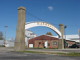
Marshall is a town in Washington Township, Parke County, Indiana, United States. As of the 2010 census, the population was 324.

<span class="mw-page-title-main">Shadeland, Indiana</span> Town in Indiana, United States

Shadeland is a town in Union Township, Tippecanoe County, in the U.S. state of Indiana. The population was 1,610 at the 2010 census.

<span class="mw-page-title-main">Fredericksburg, Indiana</span> Census-designated place in Indiana, United States

Fredericksburg is an unincorporated community in Posey Township, Washington County, in the U.S. state of Indiana. The population was 85 at the 2010 census, at the time it was a town.

<span class="mw-page-title-main">Hardinsburg, Indiana</span> Census-designated place in Indiana, United States

Hardinsburg is a census-designated place in Posey Township, Washington County, in the U.S. state of Indiana. The population was 222 at the 2020 census.

<span class="mw-page-title-main">Mount Auburn, Indiana</span> Town in Indiana, United States

Mount Auburn is a town in Jackson Township, Wayne County, in the U.S. state of Indiana. The population was 117 at the 2010 census. The town is sandwiched between Dublin and Cambridge City.

<span class="mw-page-title-main">Whitewater, Indiana</span> Town in Indiana, United States

Whitewater is a town in Franklin Township, Wayne County, in the U.S. state of Indiana. The population was 83 at the 2010 census.

<span class="mw-page-title-main">Uniondale, Indiana</span> Town in Indiana, United States

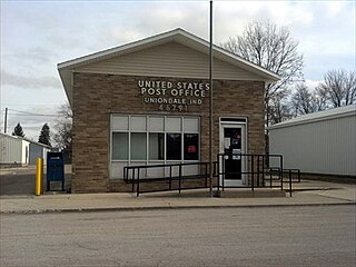
Uniondale is a town in Union and Rockcreek townships, Wells County, in the U.S. state of Indiana. The population was 310 at the 2010 census, down from 271 at the 2020 Census.

Alton is a town in Penobscot County, Maine, United States. It is part of the Bangor Metropolitan Statistical Area. The population was 829 at the 2020 census. The community is named after an Alton in England.

Crawford is a town in Washington County, Maine, United States. The town was named after William H. Crawford, Secretary of the Treasury. The population was 93 at the 2020 census.

<span class="mw-page-title-main">Alton, Missouri</span> City in Missouri, United States

Alton is a city and the county seat of Oregon County, Missouri, United States. The population was 707 at the 2020 census.

References

  1. "2020 U.S. Gazetteer Files". United States Census Bureau. Retrieved March 16, 2022.
  2. 1 2 U.S. Geological Survey Geographic Names Information System: Alton, Indiana
  3. Biographical and Historical Souvenir for the Counties of Clark, Crawford, Harrison, Floyd, Jefferson, Jennings, Scott, and Washington, Indiana. Chicago Printing Company. 1889. p.  60 via Archive.org.
  4. Cottman, George Streiby; Coleman, Christopher Bush; Esarey, Logan (1921). Indiana Magazine of History. p. 241.
  5. Baker, Ronald L. (October 1995). From Needmore to Prosperity: Hoosier Place Names in Folklore and History . Indiana University Press. p.  49. ISBN   978-0-253-32866-3. A post office established as Nebraska on March 8, 1847, was changed to Alton on July 2, 1860...
  6. "Crawford County". Jim Forte Postal History. Retrieved August 30, 2014.
  7. "G001 - Geographic Identifiers - 2010 Census Summary File 1". US Census Bureau. Archived from the original on February 13, 2020. Retrieved July 13, 2015.
  8. "Census of Population and Housing". Census.gov. Retrieved June 4, 2015.
  9. "U.S. Census website". US Census Bureau. Retrieved December 11, 2012.
  10. "U.S. Census website". US Census Bureau. Retrieved January 31, 2008.