Marengo, Indiana

Last updated

Marengo, Indiana
Marengo, Indiana.jpg
Crawford County Indiana Incorporated and Unincorporated areas Marengo Highlighted 1846746.svg
Location of Marengo in Crawford County, Indiana.
Coordinates: 38°22′24″N86°20′39″W / 38.37333°N 86.34417°W / 38.37333; -86.34417
Country United States
State Indiana
County Crawford
Township Liberty
Area
[1]
  Total0.77 sq mi (2.01 km2)
  Land0.77 sq mi (2.01 km2)
  Water0.00 sq mi (0.00 km2)
Elevation
[2]
659 ft (201 m)
Population
 (2020)
  Total829
  Density1,071.06/sq mi (413.32/km2)
Time zone UTC-5 (Eastern (EST))
  Summer (DST) UTC-4 (EDT)
ZIP code
47140
Area code 812
FIPS code 18-46746 [3]
GNIS feature ID2396735 [2]

Marengo is a town in Liberty Township, Crawford County, Indiana, United States. The population was 829 at the 2020 census. One of the tourist attractions and sources of revenue for the town is Marengo Cave, a U.S. National Landmark.

Contents

History

Marengo was originally called Big Springs, and under the latter name was platted in 1839. [4]

The name Marengo commemorates the Battle of Marengo. [5]

Marengo was devastated by an F3 tornado in 2004, resulting in damage to nearly 75 percent of the town and the death of one resident. [6]

Marengo High School was located in Marengo until the consolidation of the schools into Crawford County High School.

Geography

According to the 2010 census, Marengo has a total area of 0.77 square miles (1.99 km2), all land. [7]

Demographics

Historical population
CensusPop.Note
1890 669
1900 7004.6%
1910 686−2.0%
1920 7478.9%
1930 8067.9%
1940 8120.7%
1950 801−1.4%
1960 8030.2%
1970 767−4.5%
1980 89216.3%
1990 856−4.0%
2000 829−3.2%
2010 828−0.1%
2020 8290.1%
U.S. Decennial Census [8]

2010 census

As of the census [9] of 2010, there were 828 people, 354 households, and 213 families living in the town. The population density was 1,075.3 inhabitants per square mile (415.2/km2). There were 408 housing units at an average density of 529.9 per square mile (204.6/km2). The racial makeup of the town was 95.4% White, 0.1% African American, 0.8% Native American, 0.5% Pacific Islander, 0.5% from other races, and 2.7% from two or more races. Hispanic or Latino of any race were 2.1% of the population.

There were 354 households, of which 34.5% had children under the age of 18 living with them, 39.8% were married couples living together, 15.0% had a female householder with no husband present, 5.4% had a male householder with no wife present, and 39.8% were non-families. 36.7% of all households were made up of individuals, and 15.6% had someone living alone who was 65 years of age or older. The average household size was 2.34 and the average family size was 3.02.

The median age in the town was 36.2 years. 26.7% of residents were under the age of 18; 10.5% were between the ages of 18 and 24; 24% were from 25 to 44; 24% were from 45 to 64; and 14.5% were 65 years of age or older. The gender makeup of the town was 47.8% male and 52.2% female.

2000 census

As of the census [3] of 2000, there were 829 people, 363 households, and 218 families living in the town. The population density was 1,083.5 inhabitants per square mile (418.3/km2). There were 403 housing units at an average density of 526.7 per square mile (203.4/km2). The racial makeup of the town was 98.31% White, 0.24% Native American, 0.12% Asian, 0.12% Pacific Islander, 0.60% from other races, and 0.60% from two or more races. Hispanic or Latino of any race were 1.09% of the population.

There were 363 households, out of which 28.9% had children under the age of 18 living with them, 45.2% were married couples living together, 11.0% had a female householder with no husband present, and 39.9% were non-families. 35.0% of all households were made up of individuals, and 17.9% had someone living alone who was 65 years of age or older. The average household size was 2.28 and the average family size was 3.00.

In the town, the population was spread out, with 24.7% under the age of 18, 7.0% from 18 to 24, 28.6% from 25 to 44, 22.1% from 45 to 64, and 17.6% who were 65 years of age or older. The median age was 37 years. For every 100 females, there were 89.7 males. For every 100 females age 18 and over, there were 83.0 males.

The median income for a household in the town was $23,542, and the median income for a family was $32,019. Males had a median income of $27,109 versus $19,211 for females. The per capita income for the town was $11,194. About 13.6% of families and 23.9% of the population were below the poverty line, including 29.9% of those under age 18 and 26.1% of those age 65 or over.

Trivia

Formations seen during a tour of Marengo Cave. Marengo Cave formations.JPG
Formations seen during a tour of Marengo Cave.

Points of interest

Related Research Articles

<span class="mw-page-title-main">Zanesville, Indiana</span> Town in Indiana, United States

Zanesville is a town in Wells and Allen counties in the U.S. state of Indiana, southwest of Fort Wayne. The population was 580 at the 2020 Census, down from 600 at the 2010 census.

<span class="mw-page-title-main">Milltown, Indiana</span> Town in Indiana, United States

Milltown is a town in Whiskey Run Township in Crawford County, Indiana and in Blue River and Spencer townships in Harrison County. The population was 818 at the time of the 2010 census.

<span class="mw-page-title-main">Ashley, Indiana</span> Town in Indiana, United States

Ashley is a town in Indiana located on the border of Smithfield Township, DeKalb County and Steuben Township, Steuben County. The population was 983 at the 2010 census.

<span class="mw-page-title-main">Chesterfield, Indiana</span> Town in Indiana, United States

Chesterfield is a town in the U.S. state of Indiana which lies in Union Township, Madison County, and Salem Township, Delaware County. The population was 2,490 at the 2020 census. It is part of the Indianapolis–Carmel–Anderson metropolitan statistical area.

<span class="mw-page-title-main">Lyons, Indiana</span> Town in Indiana, United States

Lyons is a town in Washington Township, Greene County, Indiana, United States. The population was 742 at the 2010 census. It is part of the Bloomington, Indiana Metropolitan Statistical Area.

<span class="mw-page-title-main">McCordsville, Indiana</span> Town in Indiana, United States

McCordsville is a town in Vernon Township, Hancock County, Indiana, United States. The town is a fast-growing suburb of Indianapolis with an estimated population of 8,592 in 2020.

<span class="mw-page-title-main">Wilkinson, Indiana</span> Town in Indiana, United States

Wilkinson is a town in Brown Township, Hancock County, Indiana, United States. The population was 449 at the 2010 census.

<span class="mw-page-title-main">Andrews, Indiana</span> Town in Indiana, United States

Andrews is a town in Dallas Township, Huntington County, Indiana, United States. The population was 1,048 at the 2020 census.

<span class="mw-page-title-main">Medora, Indiana</span> Town in Indiana, United States

Medora is a town in Carr Township, Jackson County, Indiana, United States. The population was 693 at the 2010 census.

<span class="mw-page-title-main">Prince's Lakes, Indiana</span> Town in Indiana, United States

Prince's Lakes is a town in Nineveh Township, Johnson County, Indiana, United States. The population was 1,312 at the 2010 census.

<span class="mw-page-title-main">Silver Lake, Indiana</span> Town in Indiana, United States

Silver Lake is a town in Lake Township, Kosciusko County, in the U.S. state of Indiana. The population was 915 at the 2010 census.

<span class="mw-page-title-main">Topeka, Indiana</span> Town in Indiana, United States

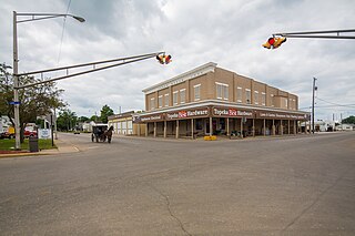
Topeka is a town in Clearspring and Eden townships, LaGrange County, Indiana, United States. The population was 1,153 at the 2010 census. Topeka is located approximately eleven miles south of Shipshewana, Indiana.

<span class="mw-page-title-main">Edgewood, Indiana</span> Town in Indiana, United States

Edgewood is a town in Anderson Township, Madison County, Indiana, United States. It is part of the Indianapolis–Carmel–Anderson metropolitan statistical area. The population was 2,053 at the 2020 census.

<span class="mw-page-title-main">Paragon, Indiana</span> Town in Indiana, United States

Paragon is a town in Ray Township, Morgan County, in the U.S. state of Indiana. The population was 556 at the 2020 census, down from 659 in 2010.

<span class="mw-page-title-main">Fillmore, Indiana</span> Town in Indiana, United States

Fillmore is a town in Marion Township, Putnam County, in the U.S. state of Indiana. The population was 532 at the 2020 census.

<span class="mw-page-title-main">Parker City, Indiana</span> Town in Indiana, United States

Parker City is a town in Monroe Township, Randolph County, in the U.S. state of Indiana. The population was 1,419 at the 2010 census.

<span class="mw-page-title-main">Hudson, Indiana</span> Town in Indiana, United States

Hudson is a town in Salem and Steuben townships, Steuben County, in the U.S. state of Indiana. The population was 518 at the 2010 census.

<span class="mw-page-title-main">Shadeland, Indiana</span> Town in Indiana, United States

Shadeland is a town in Union Township, Tippecanoe County, in the U.S. state of Indiana. The population was 1,610 at the 2010 census.

<span class="mw-page-title-main">Marengo, Ohio</span> Village in Ohio, United States

Marengo is a village in Morrow County, Ohio, United States. The population was 283 at the 2020 census. Marengo is south of Mount Gilead, the county seat.

<span class="mw-page-title-main">Meridian Hills, Indiana</span> Town in Indiana, United States

Meridian Hills is a town in Washington Township, Marion County, Indiana, about 8 miles (13 km) north of downtown Indianapolis. It had a population of 1,774 at the 2020 census, up from 1,616 in 2010.

References

  1. "2020 U.S. Gazetteer Files". United States Census Bureau. Retrieved March 16, 2022.
  2. 1 2 U.S. Geological Survey Geographic Names Information System: Marengo, Indiana
  3. 1 2 "U.S. Census website". United States Census Bureau . Retrieved January 31, 2008.
  4. Cottman, George Streiby; Coleman, Christopher Bush; Esarey, Logan (1921). Indiana Magazine of History. p. 239.
  5. Baker, Ronald L. (October 1995). From Needmore to Prosperity: Hoosier Place Names in Folklore and History . Indiana University Press. p.  210. ISBN   978-0-253-32866-3. ...Marengo, after one of Napoleon's great victories...
  6. Small Indiana town rallies to surmount a tornado's wrath, by Patrik Jonsson, The Christian Science Monitor. Retrieved on June 28, 2008.
  7. "G001 - Geographic Identifiers - 2010 Census Summary File 1". United States Census Bureau. Archived from the original on February 13, 2020. Retrieved July 17, 2015.
  8. "Census of Population and Housing". Census.gov. Retrieved June 4, 2015.
  9. "U.S. Census website". United States Census Bureau . Retrieved December 11, 2012.
  10. 1 2 Courier Press. Retrieved on June 9, 2008