Wyandot County, Ohio

Last updated

Wyandot County
Wyandot County Ohio Courthouse.JPG
Wyandot County Courthouse in Upper Sandusky
Seal of Wyandot County Ohio.svg
Map of Ohio highlighting Wyandot County.svg
Location within the U.S. state of Ohio
Ohio in United States.svg
Ohio's location within the U.S.
Coordinates: 40°51′N83°18′W / 40.85°N 83.3°W / 40.85; -83.3
CountryFlag of the United States.svg United States
StateFlag of Ohio.svg  Ohio
FoundedFebruary 3, 1845 [1]
Named for the Wyandot people
Seat Upper Sandusky
Largest cityUpper Sandusky
Area
  Total408 sq mi (1,060 km2)
  Land407 sq mi (1,050 km2)
  Water0.7 sq mi (2 km2)  0.2%
Population
 (2020)
  Total21,900
  Density54/sq mi (21/km2)
Time zone UTC−5 (Eastern)
  Summer (DST) UTC−4 (EDT)
Congressional districts 4th, 5th
Website www.co.wyandot.oh.us

Wyandot County is a county located in the northwestern part of the U.S. state of Ohio. As of the 2020 census, the population was 21,900. [2] Its county seat is Upper Sandusky. [3] It was named for the Wyandot Indians, who lived here before and after European encounter. Their autonym is variously translated from their language as "around the plains" and "dwellers on the peninsula". [4]

Contents

The county was organized by the state legislature from parts of Crawford, Marion, Hardin and Hancock counties on February 3, 1845.

History

Geography

According to the U.S. Census Bureau, the county has a total area of 408 square miles (1,060 km2), of which 407 square miles (1,050 km2) is land and 0.7 square miles (1.8 km2) (0.2%) is water. [5]

Adjacent counties

Demographics

Historical population
CensusPop.Note
1850 11,194
1860 15,59639.3%
1870 18,55319.0%
1880 22,39520.7%
1890 21,722−3.0%
1900 21,125−2.7%
1910 20,760−1.7%
1920 19,481−6.2%
1930 19,036−2.3%
1940 19,2181.0%
1950 19,7853.0%
1960 21,6489.4%
1970 21,8260.8%
1980 22,6513.8%
1990 22,254−1.8%
2000 22,9082.9%
2010 22,615−1.3%
2020 21,900−3.2%
U.S. Decennial Census [6]
1790-1960 [7] 1900-1990 [8]
1990-2000 [9] 2020 [2]

2000 census

As of the census [10] of 2000, there were 22,908 people, 8,882 households, and 6,270 families living in the county. The population density was 56 people per square mile (22 people/km2). There were 9,324 housing units at an average density of 23 units per square mile (8.9/km2). The racial makeup of the county was 97.91% White, 0.14% Black or African American, 0.08% Native American, 0.50% Asian, 0.74% from other races, and 0.62% from two or more races. 1.46% of the population were Hispanic or Latino of any race. 45.6% were of German, 19.5% American, 7.0% English and 6.9% Irish ancestry according to Census 2000.

There were 8,882 households, out of which 33.10% had children under the age of 18 living with them, 57.90% were married couples living together, 9.20% had a female householder with no husband present, and 29.40% were non-families. 25.40% of all households were made up of individuals, and 11.70% had someone living alone who was 65 years of age or older. The average household size was 2.53 and the average family size was 3.03.

In the county, the population was spread out, with 25.80% under the age of 18, 8.20% from 18 to 24, 27.90% from 25 to 44, 22.70% from 45 to 64, and 15.40% who were 65 years of age or older. The median age was 37 years. For every 100 females there were 95.10 males. For every 100 females age 18 and over, there were 92.50 males.

The median income for a household in the county was $38,839, and the median income for a family was $45,173. Males had a median income of $31,716 versus $22,395 for females. The per capita income for the county was $17,170. About 3.80% of families and 5.50% of the population were below the poverty line, including 5.20% of those under age 18 and 5.10% of those age 65 or over.

2010 census

As of the 2010 United States Census, there were 22,615 people, 9,091 households, and 6,236 families living in the county. [11] The population density was 55.6 inhabitants per square mile (21.5 inhabitants/km2). There were 9,870 housing units at an average density of 24.3 units per square mile (9.4 units/km2). [12] The racial makeup of the county was 96.9% white, 0.6% Asian, 0.2% American Indian, 0.2% black or African American, 1.1% from other races, and 1.0% from two or more races. Those of Hispanic or Latino origin made up 2.2% of the population. [11] In terms of ancestry, 43.3% were German, 11.8% were American, 11.2% were Irish, and 8.6% were English. [13]

Of the 9,091 households, 32.1% had children under the age of 18 living with them, 53.2% were married couples living together, 10.2% had a female householder with no husband present, 31.4% were non-families, and 26.5% of all households were made up of individuals. The average household size was 2.46 and the average family size was 2.95. The median age was 40.5 years. [11]

The median income for a household in the county was $47,216 and the median income for a family was $57,461. Males had a median income of $40,320 versus $30,027 for females. The per capita income for the county was $22,553. About 4.6% of families and 8.2% of the population were below the poverty line, including 11.0% of those under age 18 and 8.2% of those age 65 or over. [14]

Politics

From 1856 to 1916, Wyandot County was consistently Democratic, voting for the party's candidates in every presidential election in that span. Since 1916, it has become a strongly Republican county, voting for Republican presidential candidates in all but three elections that were national landslides for the Democratic Party, & none since 1964.

United States presidential election results for Wyandot County, Ohio [15]
Year Republican Democratic Third party
No.%No.%No.%
2020 8,46274.21%2,73323.97%2081.82%
2016 7,46870.20%2,51523.64%6556.16%
2012 6,18058.29%4,13739.02%2852.69%
2008 6,27056.99%4,46140.55%2712.46%
2004 7,25465.69%3,70833.58%810.73%
2000 6,11362.21%3,39734.57%3173.23%
1996 4,47346.56%3,67738.27%1,45715.17%
1992 4,41142.24%3,03129.02%3,00128.74%
1988 6,17866.87%2,93631.78%1251.35%
1984 7,20474.81%2,34224.32%840.87%
1980 5,78663.06%2,75730.05%6326.89%
1976 5,66156.92%4,04340.65%2422.43%
1972 6,41468.15%2,77129.44%2272.41%
1968 5,26557.90%2,91932.10%91010.01%
1964 4,13943.98%5,27356.02%00.00%
1960 6,78665.81%3,52634.19%00.00%
1956 6,80773.18%2,49526.82%00.00%
1952 7,01571.64%2,77728.36%00.00%
1948 4,84959.26%3,30840.43%250.31%
1944 6,14465.54%3,23134.46%00.00%
1940 6,27259.86%4,20640.14%00.00%
1936 4,26041.42%5,59754.41%4294.17%
1932 3,93941.42%5,45157.32%1191.25%
1928 5,79065.41%3,02434.16%380.43%
1924 3,97350.86%3,27141.88%5677.26%
1920 4,56050.50%4,44349.21%260.29%
1916 2,07838.68%3,25060.50%440.82%
1912 1,40926.94%2,84854.46%97318.60%
1908 2,40841.36%3,35357.59%611.05%
1904 2,60347.90%2,69749.63%1342.47%
1900 2,39741.68%3,26856.82%861.50%
1896 2,37440.44%3,44158.62%550.94%
1892 2,05740.25%2,85755.90%1973.85%
1888 2,25641.64%2,98155.02%1813.34%
1884 2,38043.05%3,07455.60%751.36%
1880 2,39844.46%2,98155.27%150.28%
1876 2,07944.22%2,61955.71%30.06%
1872 1,81646.13%2,09553.21%260.66%
1868 1,73444.19%2,19055.81%00.00%
1864 1,73047.94%1,87952.06%00.00%
1860 1,56747.72%1,67050.85%471.43%
1856 1,24747.36%1,27848.54%1084.10%

Government

Wyandot County is represented in the Ohio General Assembly by State Representative Riordan McClain (House District 87) and State Senator Dave Burke (Senate District 26). McClain represents the 87th Ohio House district, which also includes all of Crawford and Morrow counties as well as parts of northern Marion County and southwestern Seneca County. McClain was elected to his first full term in November 2018 after having been appointed to the seat in January 2018. Burke represents the 26th Ohio Senate district, which includes parts or all of 7 counties currently, having been appointed to the seat in July 2011.

Wyandot County has three county commissioners who oversee the various county departments. Current commissioners are: Ron Metzger, Steven Seitz and Bill Clinger. [16]

Communities

Map of Wyandot County, Ohio with municipal and township labels Map of Wyandot County Ohio With Municipal and Township Labels.PNG
Map of Wyandot County, Ohio with municipal and township labels

City

Towns and villages

Townships

Census-designated place

Unincorporated communities

Notable people

Notable places, activities, and events

The largest solar energy farm in Ohio covers 80 acres (320,000 m2) adjacent to the Wyandot County Airport. It has 159,000 ground-mounted solar panels, and can produce 12 megawatts. It was inaugurated on August 19, 2010, with Governor Ted Strickland. [18] [19] It was developed by PSEG Energy. [20]

See also

Related Research Articles

<span class="mw-page-title-main">Sandusky County, Ohio</span> County in Ohio, United States

Sandusky County is a county located in the northwestern part of the U.S. state of Ohio. As of the 2020 census, the population was 58,896. Its county seat and largest city is Fremont. The county was formed on February 12, 1820, from portions of Huron County.

<span class="mw-page-title-main">Richland County, Ohio</span> County in Ohio, United States

Richland County is a county located in the U.S. state of Ohio. As of the 2020 census, the population was 124,936. Its county seat is Mansfield. The county was created in 1808 and later organized in 1813. It is named for the fertile soil found there.

<span class="mw-page-title-main">Marion County, Ohio</span> County in Ohio, United States

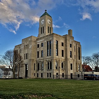
Marion County is a county located in the U.S. state of Ohio. As of the 2020 census, the population was 65,359. Its county seat is Marion. The county was created in 1820 and later organized in 1824. It is named for General Francis "The Swamp Fox" Marion, a South Carolinian officer in the Revolutionary War.

<span class="mw-page-title-main">Hancock County, Ohio</span> County in Ohio, United States

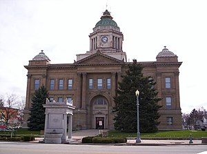
Hancock County is a county located in the U.S. state of Ohio. As of the 2020 census, the population was 74,920. Its county seat and largest city is Findlay. The county was created in 1820 and later organized in 1828. It was named for John Hancock, the first signer of the Declaration of Independence.

<span class="mw-page-title-main">Erie County, Ohio</span> County in Ohio, United States

Erie County is a county located in the northern portion of the U.S. state of Ohio. As of the 2020 census, the population was 75,622. Its county seat and largest city is Sandusky. The county is named for the Erie tribe, whose name was their word for "wildcat". It was formed in 1838 from the northern third of Huron County and a portion of Sandusky County.

<span class="mw-page-title-main">Crawford County, Ohio</span> County in Ohio, United States

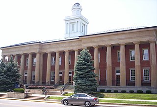
Crawford County is a county located in the north central portion of the U.S. state of Ohio. As of the 2020 census, the population was 42,025. Its county seat and largest city is Bucyrus. The county was created in 1820 and later organized in 1836. It was named for Colonel William Crawford, a soldier during the American Revolution.

<span class="mw-page-title-main">Castalia, Ohio</span> Village in Ohio, United States

Castalia is a village in Erie County, Ohio, United States. The population was 774 at the 2020 census. It is part of the Sandusky, Ohio Metropolitan Statistical Area.

<span class="mw-page-title-main">Zanesfield, Ohio</span> Village in Ohio, United States

Zanesfield is a village in Logan County, Ohio, United States of America. The population was 194 at the 2020 census. It is the smallest incorporated village in Logan County.

<span class="mw-page-title-main">Caledonia, Ohio</span> Village in Ohio, United States

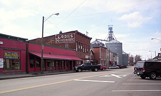
Caledonia is a village in Marion County, Ohio, United States. The population was 560 at the 2020 census.

<span class="mw-page-title-main">Clyde, Ohio</span> City in Ohio, United States

Clyde is a city in Sandusky County, Ohio, located eight miles southeast of Fremont. The population was 6,294 at the time of the 2020 census. The National Arbor Day Foundation has designated Clyde as a Tree City USA.

<span class="mw-page-title-main">Gibsonburg, Ohio</span> Village in Ohio, United States

Gibsonburg is a village in Sandusky County, Ohio, United States, about 33 miles (53 km) southeast of Toledo. The population was 2,452 at the 2020 census. The National Arbor Day Foundation has designated Gibsonburg as a Tree City USA.

<span class="mw-page-title-main">Helena, Ohio</span> Village in Ohio, United States

Helena is a village in Sandusky County, Ohio, United States. The population was 211 at the 2020 census.

<span class="mw-page-title-main">Kirby, Ohio</span> Village in Ohio, United States

Kirby is a village in Wyandot County, Ohio, United States. The population was 120 at the 2020 census.

<span class="mw-page-title-main">Marseilles, Ohio</span> Village in Ohio, United States

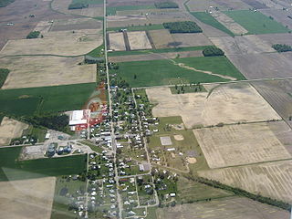
Marseilles is a village in Wyandot County, Ohio, United States, located at the western edge of the Killdeer Plains Wildlife Area. The population was 93 at the 2020 census.

<span class="mw-page-title-main">Nevada, Ohio</span> Village in Ohio, United States

Nevada is a village in Wyandot County, Ohio, United States. The population was 706 at the 2020 census.

<span class="mw-page-title-main">Sycamore, Ohio</span> Village in Ohio, United States

Sycamore is a village in Wyandot County, Ohio, United States. The population was 793 at the 2020 census.

<span class="mw-page-title-main">Upper Sandusky, Ohio</span> City in Ohio, United States

Upper Sandusky is a city in and the county seat of Wyandot County, Ohio, United States, along the upper Sandusky River. The city lies approximately 59 miles (95 km) south of Toledo and 62 miles (100 km) north of Columbus. The population was 6,698 at the 2020 census.

<span class="mw-page-title-main">Wharton, Ohio</span> Village in Ohio, United States

Wharton is a village in Wyandot County, Ohio, United States. The population was 328 at the 2020 census.

<span class="mw-page-title-main">Crestline, Ohio</span> American village in Crawford and Richland Counties in the U.S. state of Ohio

Crestline is a village in Crawford and Richland Counties in the U.S. state of Ohio. Crestline's population was 4,525 at the 2020 census. It is the third largest municipality in Crawford County. The Crawford County portion of Crestline is part of the Bucyrus Micropolitan Statistical Area, while the small portion of the village that extends into Richland County is considered part of the Mansfield Metropolitan Statistical Area. Both sections form the Mansfield–Bucyrus, OH Combined Statistical Area.

<span class="mw-page-title-main">Ottawa County, Ohio</span> County in Ohio, United States

Ottawa County is a county located in the northwestern part of the U.S. state of Ohio. As of the 2020 census, the population was 40,364. Its county seat is Port Clinton. The county is named either for the Ottawa (Odawa) Indigenous peoples who lived there, or for an Indigenous word meaning "trader".

References

  1. "Ohio County Profiles: Wyandot County" (PDF). Ohio Department of Development. Archived from the original (PDF) on June 21, 2007. Retrieved April 28, 2007.
  2. 1 2 2020 census
  3. "Find a County". National Association of Counties. Archived from the original on May 31, 2011. Retrieved June 7, 2011.
  4. "Wyandot County data". Ohio State University Extension Data Center. Retrieved April 28, 2007.[ dead link ]
  5. "2010 Census Gazetteer Files". United States Census Bureau. August 22, 2012. Archived from the original on May 4, 2014. Retrieved February 11, 2015.
  6. "U.S. Decennial Census". United States Census Bureau. Retrieved February 11, 2015.
  7. "Historical Census Browser". University of Virginia Library. Retrieved February 11, 2015.
  8. Forstall, Richard L., ed. (March 27, 1995). "Population of Counties by Decennial Census: 1900 to 1990". United States Census Bureau. Retrieved February 11, 2015.
  9. "Census 2000 PHC-T-4. Ranking Tables for Counties: 1990 and 2000" (PDF). United States Census Bureau. April 2, 2001. Archived (PDF) from the original on March 27, 2010. Retrieved February 11, 2015.
  10. "U.S. Census website". United States Census Bureau . Retrieved January 31, 2008.
  11. 1 2 3 "DP-1 Profile of General Population and Housing Characteristics: 2010 Demographic Profile Data". United States Census Bureau. Archived from the original on February 13, 2020. Retrieved December 27, 2015.
  12. "Population, Housing Units, Area, and Density: 2010 - County". United States Census Bureau. Archived from the original on February 13, 2020. Retrieved December 27, 2015.
  13. "DP02 SELECTED SOCIAL CHARACTERISTICS IN THE UNITED STATES – 2006-2010 American Community Survey 5-Year Estimates". United States Census Bureau. Archived from the original on February 13, 2020. Retrieved December 27, 2015.
  14. "DP03 SELECTED ECONOMIC CHARACTERISTICS – 2006-2010 American Community Survey 5-Year Estimates". United States Census Bureau. Archived from the original on February 13, 2020. Retrieved December 27, 2015.
  15. Leip, David. "Dave Leip's Atlas of U.S. Presidential Elections". uselectionatlas.org. Retrieved May 3, 2018.
  16. "Elected Officials". Wyandot County Courthouse Web Portal. Retrieved October 15, 2012.
  17. Who Was Who in America, Historical Volume, 1607-1896. Chicago: Marquis Who's Who. 1963.
  18. Ohio's Largest Solar Farm, solardaily.com, August 24, 2010, accessed September 2, 2010
  19. Officials hail big solar farm Archived March 5, 2012, at the Wayback Machine , Jim Maurer, "The Courier" (Findlay, Ohio), August 20, 2010, accessed September 2, 2010
  20. PSEG Wyandot, PSEG.com, accessed September 2, 2010

40°51′N83°18′W / 40.85°N 83.30°W / 40.85; -83.30