Morgan County, Ohio

Last updated

Morgan County
Morgan County Courthouse Ohio.jpg
The Morgan County Courthouse in McConnelsville
Flag of Morgan County, Ohio.png
Seal of Morgan County Ohio.svg
Map of Ohio highlighting Morgan County.svg
Location within the U.S. state of Ohio
Ohio in United States.svg
Ohio's location within the U.S.
Coordinates: 39°37′N81°51′W / 39.61°N 81.85°W / 39.61; -81.85
CountryFlag of the United States.svg United States
StateFlag of Ohio.svg  Ohio
FoundedMarch 1, 1819
Named for Daniel Morgan
Seat McConnelsville
Largest villageMcConnelsville
Area
  Total422 sq mi (1,090 km2)
  Land416 sq mi (1,080 km2)
  Water5.4 sq mi (14 km2)  1.3%
Population
 (2020)
  Total13,802
  Estimate 
(2021)
13,682 Decrease2.svg
  Density33/sq mi (13/km2)
Time zone UTC−5 (Eastern)
  Summer (DST) UTC−4 (EDT)
Congressional district 12th
Website www.morgancounty-oh.gov

Morgan County is a county located in the U.S. state of Ohio. As of the 2020 census, the population was 13,802, [1] making it the third-least populous county in Ohio. Its county seat is McConnelsville. [2] The county was created in 1817 and later organized in 1819. [3] It is named for Daniel Morgan, an officer in the American Revolutionary War. [4]

Contents

History

Morgan County was formed on December 29, 1817, from portions of Guernsey, Muskingum and Washington counties. It was named after Daniel Morgan, a member in the Congress from Virginia, and general in the American Revolutionary War.

Geography

According to the United States Census Bureau, the county has a total area of 422 square miles (1,090 km2), of which 416 square miles (1,080 km2) is land and 5.4 square miles (14 km2) (1.3%) is water. [5]

Adjacent counties

Public areas

Demographics

Historical population
CensusPop.Note
1820 5,297
1830 11,800122.8%
1840 20,85276.7%
1850 28,58537.1%
1860 22,119−22.6%
1870 20,363−7.9%
1880 20,072−1.4%
1890 19,143−4.6%
1900 17,905−6.5%
1910 16,097−10.1%
1920 14,555−9.6%
1930 13,583−6.7%
1940 14,2274.7%
1950 12,836−9.8%
1960 12,747−0.7%
1970 12,375−2.9%
1980 14,24115.1%
1990 14,194−0.3%
2000 14,8975.0%
2010 15,0541.1%
2020 13,802−8.3%
2021 (est.)13,682 [6] −0.9%
U.S. Decennial Census [7]
1790–1960 [8] 1900–1990 [9]
1990–2000 [10] 2010–2020 [1]

2000 census

As of the census of 2000, there were 14,897 people, 5,890 households, and 4,176 families living in the county. The population density was 36 people per square mile (14 people/km2). There were 7,771 housing units at an average density of 19 units per square mile (7.3/km2). The racial makeup of the county was 93.66% White, 3.41% Black or African American, 0.35% Native American, 0.08% Asian, 0.26% from other races, and 2.24% from two or more races. 0.41% of the population were Hispanic or Latino of any race.

There were 5,890 households, out of which 30.90% had children under the age of 18 living with them, 56.90% were married couples living together, 9.90% had a female householder with no husband present, and 29.10% were non-families. 25.50% of all households were made up of individuals, and 12.00% had someone living alone who was 65 years of age or older. The average household size was 2.50 and the average family size was 2.98.

In the county, the population was spread out, with 25.30% under the age of 18, 7.80% from 18 to 24, 26.30% from 25 to 44, 25.00% from 45 to 64, and 15.60% who were 65 years of age or older. The median age was 39 years. For every 100 females there were 96.50 males. For every 100 females age 18 and over, there were 94.90 males.

The median income for a household in the county was $28,868, and the median income for a family was $34,973. Males had a median income of $30,411 versus $21,039 for females. The per capita income for the county was $13,967. About 15.70% of families and 18.40% of the population were below the poverty line, including 25.10% of those under age 18 and 12.40% of those age 65 or over.

2010 census

As of the 2010 United States census, there were 15,054 people, 6,034 households, and 4,140 families living in the county. [11] The population density was 36.2 inhabitants per square mile (14.0/km2). There were 7,892 housing units at an average density of 19.0 units per square mile (7.3 units/km2). [12] The racial makeup of the county was 93.2% white, 2.9% black or African American, 0.3% American Indian, 0.1% Asian, 0.2% from other races, and 3.3% from two or more races. Those of Hispanic or Latino origin made up 0.6% of the population. [11] In terms of ancestry, 21.2% were German, 12.9% were English, 12.7% were Irish, and 9.8% were American. [13]

Of the 6,034 households, 29.7% had children under the age of 18 living with them, 53.4% were married couples living together, 10.4% had a female householder with no husband present, 31.4% were non-families, and 26.3% of all households were made up of individuals. The average household size was 2.46 and the average family size was 2.94. The median age was 42.4 years. [11]

The median income for a household in the county was $34,962 and the median income for a family was $40,440. Males had a median income of $37,173 versus $30,176 for females. The per capita income for the county was $18,777. About 15.7% of families and 19.1% of the population were below the poverty line, including 25.2% of those under age 18 and 12.6% of those age 65 or over. [14]

Politics

Morgan County is a stronghold Republican county in presidential elections. The only Democratic presidential candidates to win the county were Woodrow Wilson in 1912 and Lyndon B. Johnson in 1964, but Bill Clinton came within 181 votes of carrying it in 1996.

United States presidential election results for Morgan County, Ohio [15]
Year Republican Democratic Third party
No.%No.%No.%
2020 5,04173.53%1,72525.16%901.31%
2016 4,43168.41%1,73626.80%3104.79%
2012 3,17951.81%2,81445.86%1432.33%
2008 3,44051.96%2,96644.80%2143.23%
2004 3,75856.06%2,87542.89%701.04%
2000 3,45157.58%2,26137.73%2814.69%
1996 2,56642.97%2,38539.94%1,02017.08%
1992 2,71940.54%2,40235.81%1,58623.65%
1988 3,71363.37%2,08535.59%611.04%
1984 3,99467.66%1,86831.64%410.69%
1980 3,23660.31%1,87534.94%2554.75%
1976 2,97151.14%2,72746.94%1111.91%
1972 3,67968.50%1,55428.93%1382.57%
1968 3,03057.51%1,78933.95%4508.54%
1964 2,28142.76%3,05357.24%00.00%
1960 4,42470.82%1,82329.18%00.00%
1956 4,13473.82%1,46626.18%00.00%
1952 4,30371.94%1,67828.06%00.00%
1948 3,48065.96%1,78333.79%130.25%
1944 4,30972.13%1,66527.87%00.00%
1940 4,96665.32%2,63734.68%00.00%
1936 4,63059.35%3,09339.65%781.00%
1932 3,95754.34%3,10742.67%2182.99%
1928 4,35975.09%1,39724.07%490.84%
1924 3,55360.94%2,07235.54%2053.52%
1920 4,12764.26%2,15733.59%1382.15%
1916 2,13651.58%1,83344.26%1724.15%
1912 1,44835.70%1,63340.26%97524.04%
1908 2,44553.99%1,93242.66%1523.36%
1904 2,57258.79%1,61236.85%1914.37%
1900 2,63953.40%2,18844.27%1152.33%
1896 2,53151.12%2,37547.97%450.91%
1892 2,39951.98%1,95642.38%2605.63%
1888 2,53153.97%1,97442.09%1853.94%
1884 2,55655.13%1,97242.54%1082.33%
1880 2,51053.11%2,09144.24%1252.64%
1876 2,37651.75%2,10845.92%1072.33%
1872 2,33958.23%1,55138.61%1273.16%
1868 2,52157.09%1,89542.91%00.00%
1864 2,60160.14%1,72439.86%00.00%
1860 2,44557.03%1,75740.98%851.98%
1856 2,12553.19%1,66941.78%2015.03%

Communities

Map of Morgan County, Ohio with municipal and township labels Map of Morgan County Ohio With Municipal and Township Labels.PNG
Map of Morgan County, Ohio with municipal and township labels

Villages

Townships

Census-designated place

Unincorporated communities

See also

Related Research Articles

<span class="mw-page-title-main">Washington County, Ohio</span> County in Ohio, United States

Washington County is a county located in the southeastern part of the U.S. state of Ohio. As of the 2020 census, the population was 59,711. Its county seat is Marietta. The county, the oldest in the state, is named for George Washington. Washington County comprises the Marietta, OH Micropolitan Statistical Area, which is also included in the Parkersburg-Marietta-Vienna, WV-OH Combined Statistical Area.

<span class="mw-page-title-main">Perry County, Ohio</span> County in Ohio, United States

Perry County is a county located in the U.S. state of Ohio. As of the 2020 census, the population was 35,408. Its county seat is New Lexington. It was established on March 1, 1818, from parts of Fairfield, Washington and Muskingum counties. The county is named for Oliver Hazard Perry, a hero of the War of 1812. Perry County is included in the Columbus, OH Metropolitan Statistical Area. One of the poorest counties in the state, this is where the lawsuit challenging Ohio's school funding system, DeRolph v. State, began.

<span class="mw-page-title-main">Noble County, Ohio</span> County in Ohio, United States

Noble County is a county located in the U.S. state of Ohio. As of the 2020 census, the population was 14,115, making it the fourth-least populous county in Ohio. Its county seat is Caldwell. The county is named for Rep. Warren P. Noble of the Ohio House of Representatives, who was an early settler there.

<span class="mw-page-title-main">Muskingum County, Ohio</span> County in Ohio, United States

Muskingum County is a county located in the U.S. state of Ohio. As of the 2020 census, the population was 86,410. Its county seat is Zanesville. Nearly bisected by the Muskingum River, the county name is based on a Delaware American Indian word translated as "town by the river" or "elk's eye". Muskingum County comprises the Zanesville, OH Micropolitan Statistical Area, which is also included in the Columbus-Marion-Zanesville, OH Combined Statistical Area. The Zanesville Micropolitan Statistical Area is the second-largest statistical area within the Combined Statistical Area, after the Columbus Metropolitan Statistical Area.

<span class="mw-page-title-main">Jefferson County, Ohio</span> County in Ohio, United States

Jefferson County is a county located in the U.S. state of Ohio. As of the 2020 census, the population was 65,249. Its county seat is Steubenville. The county is named for Thomas Jefferson, who was vice president at the time of its creation.

<span class="mw-page-title-main">Guernsey County, Ohio</span> County in the United States

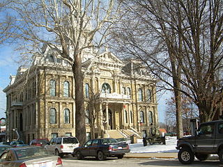
Guernsey County is a county located in the U.S. state of Ohio. As of the 2020 census, the population was 38,438. Its county seat and largest city is Cambridge. It is named for the Isle of Guernsey in the English Channel, from which many of the county's early settlers emigrated.

<span class="mw-page-title-main">Coshocton County, Ohio</span> County in Ohio, United States

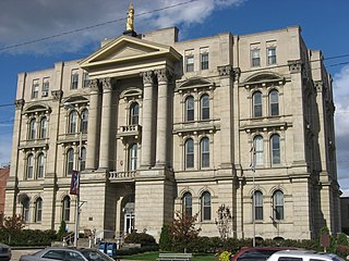
Coshocton County is a county located in the U.S. state of Ohio. As of the 2020 census, the population was 36,612. Its county seat and largest city is Coshocton. The county lies within the Appalachian region of the state. The county was formed on January 31, 1810, from portions of Muskingum and Tuscarawas Counties and later organized in 1811. Its name comes from the Delaware Indian language and has been translated as "union of waters" or "black bear crossing". Coshocton was mentioned by David Zeisberger in his diary from the 1780s using the German spelling "Goschachgünk". The Coshocton, OH Micropolitan Statistical Area includes all of Coshocton County.

<span class="mw-page-title-main">Conesville, Ohio</span> Village in Ohio, United States

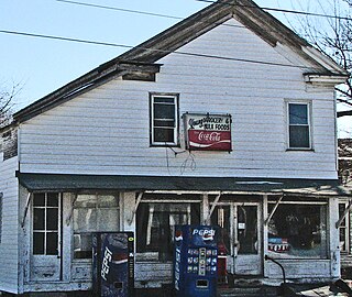
Conesville is a village in Coshocton County, Ohio, United States, along the Muskingum River. The population was 328 at the 2020 census.

<span class="mw-page-title-main">Granville South, Ohio</span> Census-designated place in Ohio, United States

Granville South is a census-designated place (CDP) in Licking County, Ohio, United States. The population was 1,420 at the 2020 census.

<span class="mw-page-title-main">Malta, Ohio</span> Village in Ohio, United States

Malta is a village in Morgan County, Ohio, United States. The population was 559 at the 2020 census.

<span class="mw-page-title-main">McConnelsville, Ohio</span> Village in Ohio, United States

McConnelsville is a village in and the county seat of Morgan County, Ohio, United States, on the east bank of the Muskingum River. Located 21 miles (34 km) southeast of Zanesville and 26 miles (42 km) northwest of Marietta, the population was 1,667 at the 2020 census.

<span class="mw-page-title-main">Adamsville, Ohio</span> Village in Ohio, United States

Adamsville is a village in Muskingum County, Ohio, United States. The population was 140 at the 2020 census. It is part of the Zanesville micropolitan area.

<span class="mw-page-title-main">Fultonham, Ohio</span> Village in Ohio, United States

Fultonham is a village in Muskingum County, Ohio, United States. The population was 115 at the 2020 census. It is part of the Zanesville micropolitan area. Fultonham was named for postmaster Robert Fulton.

<span class="mw-page-title-main">New Concord, Ohio</span> Village in Ohio, United States

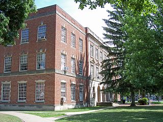
New Concord is a village in Muskingum County, Ohio, United States. The population was 2,361 as of the 2020 census. It is part of the Zanesville micropolitan area. New Concord is the home of Muskingum University and is served by a branch of the Muskingum County Library System.

<span class="mw-page-title-main">Norwich, Ohio</span> Village in Ohio, United States

Norwich is a village in Muskingum County, Ohio, United States. The population was 87 at the 2020 census. It is part of the Zanesville micropolitan area.

<span class="mw-page-title-main">Philo, Ohio</span> Village in Ohio, United States

Philo is a village in Muskingum County, Ohio, United States, along the Muskingum River. The population was 720 at the 2020 census. It is part of the Zanesville micropolitan area. Philo is the closest municipality to Blue Rock State Park.

<span class="mw-page-title-main">South Zanesville, Ohio</span> Village in Ohio, United States

South Zanesville is a village in Muskingum County, Ohio, United States, along the Muskingum River near the mouth of the Moxahala Creek. The population was 1,894 at the 2020 census. It is part of the Zanesville micropolitan area.

<span class="mw-page-title-main">Lowell, Ohio</span> Village in Ohio, United States

Lowell is a village in Washington County, Ohio, United States, along the Muskingum River. The population was 549 at the 2020 census. The village is located about 7.6 miles (12.2 km) north of Marietta, Ohio.

<span class="mw-page-title-main">Gratiot, Ohio</span> Village in Ohio, United States

Gratiot is a village in Licking and Muskingum counties in the U.S. state of Ohio. The population was 215 at the 2020 census.

<span class="mw-page-title-main">Roseville, Ohio</span> Village in Ohio, United States

Roseville is a village in Muskingum and Perry counties in the U.S. state of Ohio, along Moxahala Creek. The population was 1,746 at the 2020 census. It is part of the Zanesville micropolitan area. Roseville is served by a branch of the Muskingum County Library System.

References

  1. 1 2 "State & County QuickFacts". United States Census Bureau. Retrieved October 21, 2022.
  2. "Find a County". National Association of Counties. Archived from the original on May 31, 2011. Retrieved June 7, 2011.
  3. "Ohio: Individual County Chronologies". Ohio Atlas of Historical County Boundaries. The Newberry Library. 2007. Archived from the original on April 6, 2016. Retrieved February 14, 2015.
  4. "Morgan County data". Ohio State University Extension Data Center. Retrieved April 28, 2007.[ dead link ]
  5. "2010 Census Gazetteer Files". Census.gov . United States Census Bureau. August 22, 2012. Archived from the original on May 4, 2014. Retrieved February 9, 2015.
  6. "Annual Estimates of the Resident Population for Counties: April 1, 2020 to July 1, 2021" . Retrieved October 21, 2022.
  7. "U.S. Decennial Census". United States Census Bureau. Retrieved February 9, 2015.
  8. "Historical Census Browser". University of Virginia Library. Retrieved February 9, 2015.
  9. Forstall, Richard L., ed. (March 27, 1995). "Population of Counties by Decennial Census: 1900 to 1990". United States Census Bureau. Retrieved February 9, 2015.
  10. "Census 2000 PHC-T-4. Ranking Tables for Counties: 1990 and 2000" (PDF). United States Census Bureau. April 2, 2001. Archived (PDF) from the original on March 27, 2010. Retrieved February 9, 2015.
  11. 1 2 3 "DP-1 Profile of General Population and Housing Characteristics: 2010 Demographic Profile Data". United States Census Bureau. Archived from the original on February 13, 2020. Retrieved December 27, 2015.
  12. "Population, Housing Units, Area, and Density: 2010 - County". United States Census Bureau. Archived from the original on February 13, 2020. Retrieved December 27, 2015.
  13. "DP02 SELECTED SOCIAL CHARACTERISTICS IN THE UNITED STATES – 2006-2010 American Community Survey 5-Year Estimates". United States Census Bureau. Archived from the original on February 13, 2020. Retrieved December 27, 2015.
  14. "DP03 SELECTED ECONOMIC CHARACTERISTICS – 2006-2010 American Community Survey 5-Year Estimates". United States Census Bureau. Archived from the original on February 13, 2020. Retrieved December 27, 2015.
  15. Leip, David. "Dave Leip's Atlas of U.S. Presidential Elections". uselectionatlas.org. Retrieved May 2, 2018.

Further reading

39°37′N81°51′W / 39.61°N 81.85°W / 39.61; -81.85