Warren County is a county located in the southwestern part of the U.S. state of Ohio. As of the 2020 census, the population was 242,337. Its county seat is Lebanon and largest city is Mason. The county is one of Ohio's most affluent, with the highest median income of the state's 88 counties. The county was established on May 1, 1803, from Hamilton County; it is named for Dr. Joseph Warren, a hero of the Revolution who sent Paul Revere and the overlooked William Dawes on their famous rides and who died at the Battle of Bunker Hill. Warren County is part of the Cincinnati, OH-KY-IN Metropolitan Statistical Area.

Butler County is a county located in the southwestern part of the U.S. state of Ohio. As of the 2020 census, the population was 390,357. Its county seat and largest city is Hamilton. It is named for General Richard Butler, who died in 1791 during St. Clair's Defeat. Located along the Great Miami River, it is also home to Miami University, a public university founded in 1809. Butler County is part of the Cincinnati, OH-KY-IN Metropolitan Statistical Area. The majority of the county is in District 52 of the State House.

Middletown is a city located in Butler and Warren counties in the southwestern part of the U.S. state of Ohio, about 35 miles (47 km) north of Cincinnati. The population as of the 2020 census was 50,987. It is part of the Cincinnati metropolitan area.

The Little Miami Scenic Trail is the fourth longest paved trail in the United States, running 78.1 miles (125.7 km) through five southwestern counties in the state of Ohio. The multi-use rail trail sees heavy recreational use by hikers and bicyclists, as well as the occasional horseback rider. Over 700,000 people made use of the trail in 2014.
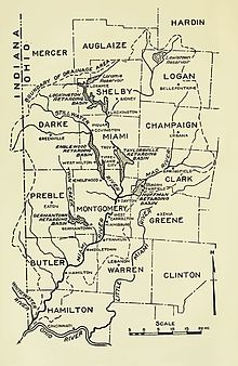
The Little Miami Railroad was a railway of southwestern Ohio, running from the eastern side of Cincinnati to Springfield, Ohio. By merging with the Columbus and Xenia Railroad in 1853, it created the first through-rail route from the important manufacturing city of Cincinnati to the state capital, Columbus. In this period, railroads were important for creating connections between the important waterways of the Great Lakes and the Ohio River, which were major transportation routes for products to other markets.
The Middletown and Cincinnati Railroad is a historic railroad that operated in the southwest portion of the U.S. state of Ohio.

The Cincinnati, Lebanon and Northern Railway (CL&N) was a local passenger and freight-carrying railroad in the southwestern part of the U.S. state of Ohio, connecting Cincinnati to Dayton via Lebanon. It was built in the late 19th century to give the town of Lebanon and Warren County better transportation facilities. The railroad was locally known as the "Highland Route", since it followed the ridge between the Little and Great Miami rivers, and was the only line not affected by floods such as the Great Dayton Flood of 1913.
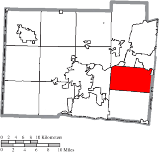
Liberty Township is a suburb of Cincinnati located in Butler County, Ohio. It is one of thirteen townships in Butler County, Ohio, United States. The population was 43,999 at the 2020 census. It is located on the east-central part of the county, just south of the city of Monroe. It was named for Liberty, Pennsylvania, at the suggestion of John Morrow, a resident in the township at the time of its formation in 1803 who was the brother of Ohio Governor Jeremiah Morrow, after his hometown. The first settler was John Nelson, who arrived in 1796, seven years before Ohio became a state. It is one of 25 Liberty Townships statewide.

State Route 4, formerly known as Inter-county Highway 4 until 1921 and State Highway 4 in 1922, is a major north–south state highway in Ohio. It is the fifth longest state route in Ohio. Its southern terminus is at U.S. Route 42 in Cincinnati, Ohio, and its northern terminus is at U.S. Route 6 in Sandusky, Ohio. Its path is nearly ruler-straight for many miles. Some portions of the route are still marked as Dixie Highway. The northern portion was constructed by the Columbus and Sandusky Turnpike Company, see Turnpike Lands.
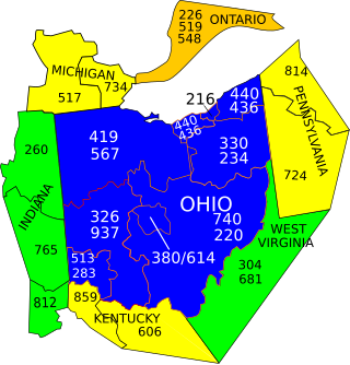
Area codes 937 and 326 are telephone area codes in the North American Numbering Plan (NANP) assigned to a numbering plan area (NPA) that encompasses much of the southwestern part of the U.S. state of Ohio, including Dayton and Springfield. Area code 937 was established in September 1996, in a split of area code 513. Area code 326 was added to the numbering plan area to form an overlay complex in March 2020.

Interstate 75 (I-75) runs from Cincinnati to Toledo by way of Dayton in the US state of Ohio. The highway enters the state running concurrently with I-71 from Kentucky on the Brent Spence Bridge over the Ohio River and into the Bluegrass region. I-75 continues along the Mill Creek Expressway northward to the Butler County line just north of I-275. From there, the freeway runs into the Miami Valley and then passes through the Great Black Swamp before crossing into Michigan.

WFCJ is a radio station licensed to Miamisburg, Ohio, serving the Dayton metropolitan area. Owned by Strong Tower Christian Media, it broadcasts a Christian talk and teaching radio format. The station is funded by both advertising and listener donations. Some of the national religious leaders heard on WFCJ include Charles Stanley, David Jeremiah, Chuck Swindoll, Jim Daly and Rick Warren. Strong Tower Christian Media operates two 50,000 watt Christian radio stations in Ohio. WFCJ and 100.7 WEEC in Springfield serve the cities of Dayton, Middletown, Cincinnati and parts of Northern Kentucky and Eastern Indiana.
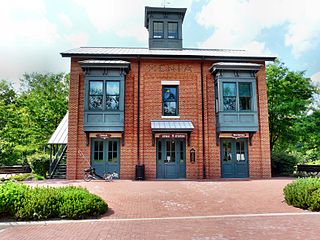
Xenia Station, located at 150 Miami Avenue in Xenia, Ohio, in the United States, is a replica of Xenia's 1880s brick railroad station.

The Dayton, OH Metropolitan Statistical Area, also known as Greater Dayton and the Miami Valley, as defined by the United States Census Bureau, is an area consisting of three counties in the Miami Valley region of Ohio and is anchored by the city of Dayton. As of 2020, it is the fourth largest metropolitan area in Ohio and the 73rd largest metropolitan area by population in the United States with a population of 814,049.
The following is a list of media in Dayton, Ohio, United States.
Cincinnati has several modes of transportation including sidewalks, roads, public transit, bicycle paths and regional and international airports. Most trips are made by car, with transit and bicycles having a relatively low share of total trips; in a region of just over 2 million people, less than 80,000 trips are made with transit on an average day. The city is sliced by three major interstate highways, I-71, I-74 and I-75, and circled by a beltway several miles out from the city limits. The region is served by two separate transit systems, one on each side of the river. SORTA, on the Ohio side is about 6 times larger than TANK on the Kentucky side. The transit system is largely radial with almost all lines terminating in or departing from Downtown Cincinnati. The city's hills preclude the regular street grid common to many cities built up in the 19th century, and outside of the downtown basin, regular street grids are rare except for in patches of flat land where they're small and oriented according to topography.
This is a list of high school athletic conferences in the Southwest Region of Ohio, as defined by the OHSAA. Because the names of localities and their corresponding high schools do not always match and because there is often a possibility of ambiguity with respect to either the name of a locality or the name of a high school, the following table gives both in every case, with the locality name first, in plain type, and the high school name second in boldface type. The school's team nickname is given last.
This is a list of former high school athletic conferences in the Southwest Region of Ohio, as designated by the Ohio High School Athletic Association. If a conference had members that span multiple regions, the conference is placed in the article of the region most of its former members hail from. Because the names of localities and their corresponding high schools do not always match and because there is often a possibility of ambiguity with respect to either the name of a locality or the name of a high school, the following table gives both in every case, with the locality name first, in plain type, and the high school name second in boldface type. The school's team nickname is given last.

The Cincinnati metropolitan area is a metropolitan area with its core in Ohio and Kentucky. Its largest city is Cincinnati and includes surrounding counties in the U.S. states of Ohio, Kentucky, and Indiana.