Sandusky County, Ohio

Last updated

Sandusky County
Sandusky County Ohio Courthouse.JPG
Sandusky County Courthouse in Fremont
Seal of Sandusky County Ohio.svg
Map of Ohio highlighting Sandusky County.svg
Location within the U.S. state of Ohio
Ohio in United States.svg
Ohio's location within the U.S.
Coordinates: 41°22′N83°09′W / 41.36°N 83.15°W / 41.36; -83.15
CountryFlag of the United States.svg United States
StateFlag of Ohio.svg  Ohio
FoundedFebruary 12, 1820 [1]
Named for Sandusky River
Seat Fremont
Largest cityFremont
Area
  Total418 sq mi (1,080 km2)
  Land408 sq mi (1,060 km2)
  Water9.3 sq mi (24 km2)  2.2%
Population
 (2020)
  Total58,896
  Density140/sq mi (54/km2)
Time zone UTC−5 (Eastern)
  Summer (DST) UTC−4 (EDT)
Congressional district 9th
Website www.sandusky-county.com

Sandusky County is a county located in the northwestern part of the U.S. state of Ohio. As of the 2020 census, the population was 58,896. [2] Its county seat and largest city is Fremont. [3] The county was formed on February 12, 1820, from portions of Huron County.

Contents

The name is derived from the Wyandot word meaning "water" (Wyandot : saandustee). [4] The Sandusky River runs diagonally northeast through the county to its mouth on Sandusky Bay, opening into Lake Erie. Sandusky County compromises the Fremont, OH Micropolitan Statistical Area.

Geography

According to the U.S. Census Bureau, the county has a total area of 418 square miles (1,080 km2), of which 408 square miles (1,060 km2) is land and 9.3 square miles (24 km2) (2.2%) is water. [5]

Adjacent counties

Demographics

Historical population
CensusPop.Note
1820 852
1830 2,851234.6%
1840 10,182257.1%
1850 14,30540.5%
1860 21,42949.8%
1870 25,50319.0%
1880 32,05725.7%
1890 30,617−4.5%
1900 34,31112.1%
1910 35,1712.5%
1920 37,1095.5%
1930 39,7317.1%
1940 41,0143.2%
1950 46,11412.4%
1960 56,48622.5%
1970 60,9838.0%
1980 63,2673.7%
1990 61,963−2.1%
2000 61,792−0.3%
2010 60,944−1.4%
2020 58,896−3.4%
U.S. Decennial Census [6]
1790-1960 [7] 1900-1990 [8]
1990-2000 [9] 2020 [2]

2000 census

As of the census [10] of 2000, there were 61,792 people, 23,717 households, and 16,957 families living in the county. The population density was 151 inhabitants per square mile (58/km2). There were 25,253 housing units at an average density of 62 units per square mile (24/km2). The racial makeup of the county was 92.20% White, 2.67% Black or African American, 0.13% Native American, 0.29% Asian, 0.01% Pacific Islander, 3.10% from other races, and 1.61% from two or more races. 6.96% of the population were Hispanic or Latino of any race.

There were 23,717 households, out of which 33.30% had children under the age of 18 living with them, 56.50% were married couples living together, 10.50% had a female householder with no husband present, and 28.50% were non-families. 24.10% of all households were made up of individuals, and 10.60% had someone living alone who was 65 years of age or older. The average household size was 2.56 and the average family size was 3.04.

In the county, the population was spread out, with 26.20% under the age of 18, 8.10% from 18 to 24, 28.30% from 25 to 44, 23.00% from 45 to 64, and 14.50% who were 65 years of age or older. The median age was 37 years. For every 100 females there were 95.90 males. For every 100 females age 18 and over, there were 92.60 males.

The median income for a household in the county was $40,584, and the median income for a family was $47,675. Males had a median income of $35,501 versus $23,964 for females. The per capita income for the county was $19,239. About 5.70% of families and 7.50% of the population were below the poverty line, including 9.10% of those under age 18 and 7.00% of those age 65 or over.

2010 census

As of the 2010 United States Census, there were 60,944 people, 24,182 households, and 16,616 families living in the county. [11] The population density was 149.2 inhabitants per square mile (57.6/km2). There were 26,390 housing units at an average density of 64.6 units per square mile (24.9 units/km2). [12] The racial makeup of the county was 91.2% white, 2.8% black or African American, 0.3% Asian, 0.2% American Indian, 2.8% from other races, and 2.6% from two or more races. Those of Hispanic or Latino origin made up 8.9% of the population. [11] In terms of ancestry, 41.9% were German, 12.1% were Irish, 9.5% were English, and 7.1% were American. [13]

Of the 24,182 households, 32.0% had children under the age of 18 living with them, 51.3% were married couples living together, 12.1% had a female householder with no husband present, 31.3% were non-families, and 26.3% of all households were made up of individuals. The average household size was 2.48 and the average family size was 2.97. The median age was 40.4 years. [11]

The median income for a household in the county was $48,056 and the median income for a family was $57,500. Males had a median income of $42,582 versus $31,257 for females. The per capita income for the county was $22,286. About 7.2% of families and 10.9% of the population were below the poverty line, including 15.8% of those under age 18 and 6.5% of those age 65 or over. [14]

Government and politics

Like most of northwestern Ohio, Sandusky County voters have historically supported the Republican Party. It was initially settled by migrants from the Northern Tier of New England and New York, who carried their culture with them. The county has a strong history of supporting Republican presidential candidates as well as local Republican candidates.

During the 2008 U.S. presidential election, 51% of the voters from Sandusky County supported Democratic candidate Barack Obama. [15] It was the second time since 1964 that the county had supported a Democrat for president, and the second time since 1932 that it had done so with a majority. Obama narrowly carried the county again in the 2012 U.S. presidential election with just under 50 percent of the vote. [16] Time magazine listed Sandusky as one of five critical counties in the 2012 election. [17] In 2016 and 2020 the county supported the Republican candidate.

United States presidential election results for Sandusky County, Ohio [18]
Year Republican Democratic Third party
No.%No.%No.%
2020 18,89662.72%10,59635.17%6362.11%
2016 16,31657.68%9,92935.10%2,0407.21%
2012 13,75547.28%14,54149.98%7992.75%
2008 14,19246.72%15,60251.36%5831.92%
2004 16,22455.92%12,68643.72%1040.36%
2000 13,69953.21%11,14643.30%8993.49%
1996 10,03339.48%11,54745.44%3,83315.08%
1992 10,77239.21%9,87835.96%6,82224.83%
1988 14,20358.61%9,70940.07%3201.32%
1984 17,21466.16%8,56432.91%2420.93%
1980 13,42055.53%8,48235.10%2,2649.37%
1976 13,07452.58%11,20245.05%5912.38%
1972 15,48963.63%8,30834.13%5462.24%
1968 11,69653.10%8,58138.96%1,7487.94%
1964 8,25437.98%13,48162.02%00.00%
1960 14,56664.06%8,17135.94%00.00%
1956 15,00972.52%5,68727.48%00.00%
1952 14,93971.18%6,04828.82%00.00%
1948 10,84759.93%7,21639.87%360.20%
1944 13,76369.19%6,12930.81%00.00%
1940 14,05466.39%7,11633.61%00.00%
1936 8,69242.89%9,17145.26%2,40211.85%
1932 8,91545.74%10,29952.84%2761.42%
1928 12,20067.33%5,83432.20%850.47%
1924 9,38160.88%4,38828.48%1,63910.64%
1920 8,93361.77%5,29536.62%2331.61%
1916 3,55739.36%5,26458.25%2162.39%
1912 1,57618.43%4,33350.66%2,64430.91%
1908 4,07942.74%5,24254.93%2222.33%
1904 4,20850.38%3,78745.34%3584.29%
1900 4,00344.26%4,91554.35%1261.39%
1896 3,97043.28%5,10555.66%971.06%
1892 2,96041.25%3,77452.60%4416.15%
1888 3,21844.10%3,91753.68%1622.22%
1884 3,13045.10%3,68453.08%1261.82%
1880 3,05944.49%3,64052.94%1772.57%
1876 3,03247.31%3,33051.96%470.73%
1872 2,38046.26%2,72953.04%360.70%
1868 2,44346.19%2,84653.81%00.00%
1864 2,29449.09%2,37950.91%00.00%
1860 1,93845.28%2,31954.18%230.54%
1856 1,54848.50%1,59950.09%451.41%

County officials

OfficeNameParty
CommissionerScott MillerRepublican
CommissionerCharles SchwochowRepublican
CommissionerRuss ZimmermanRepublican
ProsecutorBeth A. TischlerRepublican
SheriffChristopher J. HiltonRepublican
Clerk of CourtsChris SchneiderRepublican
RecorderColleen CarmackRepublican
TreasurerKimberley ForemanRepublican
EngineerCarlos BaezRepublican
CoronerJames WilliamsDemocrat
AuditorJerri A. MillerRepublican
Common Pleas Court JudgeJon IckesRepublican
Common Pleas Court JudgeJeremiah RayDemocrat
County Courts JudgeJohn P. KolesarDemocrat
County Courts JudgeMary Elizabeth FiserRepublican
Juvenile Court JudgeBrad SmithRepublican

[19]

Transportation

Major highways

Other highways

Airports

Communities

Map of Sandusky County, Ohio with municipal and township labels Map of Sandusky County Ohio With Municipal and Township Labels.PNG
Map of Sandusky County, Ohio with municipal and township labels

Cities

Villages

Townships

Census-designated places

Unincorporated communities

Places of interest

See also

Related Research Articles

<span class="mw-page-title-main">Wyandot County, Ohio</span> County in Ohio, United States

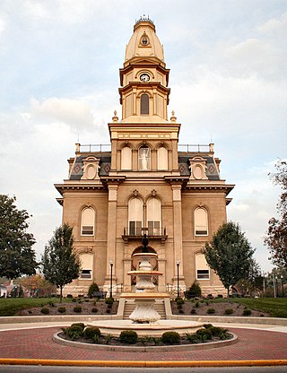
Wyandot County is a county located in the northwestern part of the U.S. state of Ohio. As of the 2020 census, the population was 21,900. Its county seat is Upper Sandusky. It was named for the Wyandot Indians, who lived here before and after European encounter. Their autonym is variously translated from their language as "around the plains" and "dwellers on the peninsula".

<span class="mw-page-title-main">Seneca County, Ohio</span> County in Ohio, United States

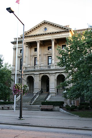
Seneca County is a county located in the northwestern part of the U.S. state of Ohio. As of the 2020 census, the population was 55,069. Its county seat is Tiffin. The county was created in 1820 and organized in 1824. It is named for the Seneca Indians, the westernmost nation of the Iroquois Confederacy. This people were based in present-day New York but had territory extending into Pennsylvania and Ohio.

<span class="mw-page-title-main">Marion County, Ohio</span> County in Ohio, United States

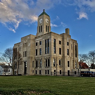
Marion County is a county located in the U.S. state of Ohio. As of the 2020 census, the population was 65,359. Its county seat is Marion. The county was created in 1820 and later organized in 1824. It is named for General Francis "The Swamp Fox" Marion, a South Carolinian officer in the Revolutionary War.

<span class="mw-page-title-main">Lorain County, Ohio</span> County in Ohio, United States

Lorain County is a county in the northeastern part of the U.S. state of Ohio As of the 2020 census, the population was 312,964. Its county seat is Elyria, and its largest city is Lorain.

<span class="mw-page-title-main">Logan County, Ohio</span> County in Ohio, United States

Logan County is a county in the west central portion of the U.S. state of Ohio. As of the 2020 census, the population was 46,150. The county seat is Bellefontaine. The county is named for Benjamin Logan, who fought Native Americans in the area.

<span class="mw-page-title-main">Huron County, Ohio</span> County in Ohio, United States

Huron County is a county located in the U.S. state of Ohio. As of the 2020 census, the population was 58,565. Its county seat is Norwalk. The county was created in 1809 and later organized in 1815.

<span class="mw-page-title-main">Erie County, Ohio</span> County in Ohio, United States

Erie County is a county located in the northern portion of the U.S. state of Ohio. As of the 2020 census, the population was 75,622. Its county seat and largest city is Sandusky. The county is named for the Erie tribe, whose name was their word for "wildcat". It was formed in 1838 from the northern third of Huron County and a portion of Sandusky County.

<span class="mw-page-title-main">Crawford County, Ohio</span> County in Ohio, United States

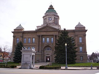
Crawford County is a county located in the north central portion of the U.S. state of Ohio. As of the 2020 census, the population was 42,025. Its county seat and largest city is Bucyrus. The county was created in 1820 and later organized in 1836. It was named for Colonel William Crawford, a soldier during the American Revolution.

<span class="mw-page-title-main">Fremont County, Iowa</span> County in Iowa, United States

Fremont County is a county located in the U.S. state of Iowa. As of the 2020 census the population was 6,605, making it the state's seventh-least populous county. The county seat is Sidney. The county was formed in 1847 and named for the military officer John C. Frémont.

<span class="mw-page-title-main">Zanesfield, Ohio</span> Village in Ohio, United States

Zanesfield is a village in Logan County, Ohio, United States of America. The population was 194 at the 2020 census. It is the smallest incorporated village in Logan County.

<span class="mw-page-title-main">Ballville, Ohio</span> CDP in Ohio, United States

Ballville is a census-designated place (CDP) in Sandusky County, Ohio, United States, adjacent to Fremont. The population was 3,823 at the 2020 census.

<span class="mw-page-title-main">Burgoon, Ohio</span> Village in Ohio, United States

Burgoon is a village in Sandusky County, Ohio, United States. The population was 183 at the 2020 census.

<span class="mw-page-title-main">Fremont, Ohio</span> City in Ohio, United States

Fremont is a city in and the county seat of Sandusky County, Ohio, United States, along the Sandusky River. It is about 35 miles (56 km) southeast of Toledo and 25 miles (40 km) west of Sandusky. The population was 15,930 at the 2020 census.

<span class="mw-page-title-main">Gibsonburg, Ohio</span> Village in Ohio, United States

Gibsonburg is a village in Sandusky County, Ohio, United States, about 33 miles (53 km) southeast of Toledo. The population was 2,452 at the 2020 census. The National Arbor Day Foundation has designated Gibsonburg as a Tree City USA.

<span class="mw-page-title-main">Helena, Ohio</span> Village in Ohio, United States

Helena is a village in Sandusky County, Ohio, United States. The population was 211 at the 2020 census.

<span class="mw-page-title-main">Woodville, Ohio</span> Village in Ohio, United States

Woodville is a village in Sandusky County, Ohio, United States. The population was 2,006 at the 2020 census. The National Arbor Day Foundation has designated Woodville as a Tree City USA.

<span class="mw-page-title-main">Upper Sandusky, Ohio</span> City in Ohio, United States

Upper Sandusky is a city in and the county seat of Wyandot County, Ohio, United States, along the upper Sandusky River. The city lies approximately 59 miles (95 km) south of Toledo and 62 miles (100 km) north of Columbus. The population was 6,698 at the 2020 census.

<span class="mw-page-title-main">Bellevue, Ohio</span> City in Ohio, United States

Bellevue is a city in Erie, Huron, Seneca, and Sandusky counties in the U.S. state of Ohio, located 61 miles southwest of Cleveland and 45 miles southeast of Toledo. The population was 8,249 at the 2020 census. The National Arbor Day Foundation has designated Bellevue as a Tree City USA.

<span class="mw-page-title-main">Elmore, Ohio</span> Village in Ohio, United States

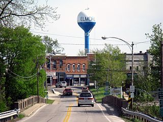
Elmore is a village in Ottawa and Sandusky counties in the U.S. state of Ohio. The population was 1,370 at the 2020 census.

<span class="mw-page-title-main">Ottawa County, Ohio</span> County in Ohio, United States

Ottawa County is a county located in the northwestern part of the U.S. state of Ohio. As of the 2020 census, the population was 40,364. Its county seat is Port Clinton. The county is named either for the Ottawa (Odawa) Indigenous peoples who lived there, or for an Indigenous word meaning "trader".

References

  1. "Ohio County Profiles: Sandusky County" (PDF). Ohio Department of Development. Archived from the original (PDF) on June 21, 2007. Retrieved April 28, 2007.
  2. 1 2 2020 census
  3. "Find a County". National Association of Counties. Retrieved June 7, 2011.
  4. American Language Reprint database Archived June 10, 2011, at the Wayback Machine
  5. "2010 Census Gazetteer Files". United States Census Bureau. August 22, 2012. Archived from the original on May 4, 2014. Retrieved February 11, 2015.
  6. "U.S. Decennial Census". United States Census Bureau. Retrieved February 11, 2015.
  7. "Historical Census Browser". University of Virginia Library. Retrieved February 11, 2015.
  8. Forstall, Richard L., ed. (March 27, 1995). "Population of Counties by Decennial Census: 1900 to 1990". United States Census Bureau. Retrieved February 11, 2015.
  9. "Census 2000 PHC-T-4. Ranking Tables for Counties: 1990 and 2000" (PDF). United States Census Bureau. April 2, 2001. Archived (PDF) from the original on March 27, 2010. Retrieved February 11, 2015.
  10. "U.S. Census website". United States Census Bureau . Retrieved January 31, 2008.
  11. 1 2 3 "DP-1 Profile of General Population and Housing Characteristics: 2010 Demographic Profile Data". United States Census Bureau. Archived from the original on February 13, 2020. Retrieved December 27, 2015.
  12. "Population, Housing Units, Area, and Density: 2010 - County". United States Census Bureau. Archived from the original on February 13, 2020. Retrieved December 27, 2015.
  13. "DP02 SELECTED SOCIAL CHARACTERISTICS IN THE UNITED STATES – 2006-2010 American Community Survey 5-Year Estimates". United States Census Bureau. Archived from the original on February 13, 2020. Retrieved December 27, 2015.
  14. "DP03 SELECTED ECONOMIC CHARACTERISTICS – 2006-2010 American Community Survey 5-Year Estimates". United States Census Bureau. Archived from the original on February 13, 2020. Retrieved December 27, 2015.
  15. "Local and National Election Results - Election Center 2008 - Elections & Politics from CNN.com". www.cnn.com. Retrieved April 6, 2018.
  16. "2012 election results from Ohio" . Retrieved November 7, 2012.
  17. "The White House - Obama's Path to Victory", Time , pp. 16–17, November 19, 2012
  18. Leip, David. "Dave Leip's Atlas of U.S. Presidential Elections". uselectionatlas.org. Retrieved April 6, 2018.
  19. "Sandusky County, Ohio - Sandusky County, Ohio". www.sandusky-county.org. Retrieved April 6, 2018.

41°22′N83°09′W / 41.36°N 83.15°W / 41.36; -83.15