US Route 223 or US Highway 223 (US 223) is a diagonal (northwest–southeast) United States Numbered Highway lying in the states of Michigan and Ohio. The southernmost section is completely concurrent with the US 23 freeway, including all of the Ohio segment. It connects US 23 in the south near Toledo, Ohio, with US 127 south of Jackson, Michigan. The highway passes through farmland in southern Michigan and woodland in the Irish Hills. Including the concurrency on the southern end, US 223 is 46.34 miles (74.58 km) in total length.

State Route 120 is an east–west state highway in the northwestern portion of the U.S. state of Ohio. Its western terminus is at the Michigan state line, where an unnumbered county highway continues west-northwest. State Route 120’s eastern terminus is in Toledo at State Route 65; the route is, for all practical purposes, a spur of U.S. Route 20, which generally bypasses Toledo to the west and south.

U.S. Route 23 or U.S. Highway 23 (US 23) is a major north–south United States Numbered Highway between Jacksonville, Florida, and Mackinaw City, Michigan. It is an original 1926 route which originally reached only as far south as Portsmouth, Ohio, and has since been extended. It was formerly part of the major highway known as the Dixie Highway. The highway's southern terminus is in Jacksonville, Florida, at US 1/US 17. The northern terminus is at Interstate 75 (I-75) in Mackinaw City, Michigan.

State Route 25 (SR 25) is an Ohio state route that runs between Cygnet and Toledo in the US state of Ohio. The highway has a total length of 34.98 miles (56.29 km). Some of the highway is listed on the National Highway System and various sections are rural four-lane highways and urbanized four-lane divided highways. SR 25 passes through farmland, commercial and residential properties.
Interstate 475 (I-475) is an auxiliary Interstate Highway in Ohio that is a 20.37-mile (32.78 km) western bypass of Toledo. The southern terminus is I-75 exit 192 near Perrysburg. From the southern terminus to exit 14, I-475 is cosigned with US Route 23 (US 23) and is signed the north–south section of I-475. From exit 14 to the eastern (northernmost) terminus at I-75 exit 204 in central Toledo, it is signed the east–west section of I-475.
Interstate 280 (I-280) is a 12.41-mile-long (19.97 km) auxiliary Interstate Highway in Ohio that connects I-75 in northeast Toledo with I-80/I-90 southeast of the city in northeastern Wood County. Built between 1955 and 1959, the route was originally part of the Detroit–Toledo Expressway. Although first designated in 1959, the highway originally contained several at-grade intersections and other features which left it substandard to the Interstate Highway System until 1990. Further construction in 2007 built a new crossing of the Maumee River, replacing an outdated drawbridge. The highway serves as an easterly bypass of the Toledo metropolitan area, passing through the communities of Northwood and Oregon. It is one of two auxiliary Interstate Highways serving Toledo, the other being I-475.

State Route 184 (SR 184) is a 10.14-mile (16.32 km) long east–west state highway in northwestern Ohio, a U.S. state. The western terminus of SR 184 is at the U.S. Route 23 (US 23) freeway in Sylvania, at a five-ramp parclo AB-3 interchange that also serves as the southern terminus of US 223, as well as the northern terminus of SR 51. The eastern terminus of SR 184 is at a diamond interchange with Interstate 75 in Toledo.

State Route 420 (SR 420) is a north–south state highway in the northwestern portion of the U.S. state of Ohio. The southern terminus of this four-lane divided highway is at a trumpet interchange with U.S. Route 20/US 23 (US 20/US 23) approximately 3.25 miles (5.23 km) northeast of the village of Luckey. The route’s northern terminus is at the southern terminus of Interstate 280 (I-280), where the two routes meet the Ohio Turnpike (I-80/I-90) at a double-trumpet interchange nearly four miles (6.4 km) southwest of Millbury. SR 420 made its debut in the late 1960s. It is a major route whose primary purpose is to link US 20/US 23 with I-280 and the Ohio Turnpike.

State Route 65 is a north–south highway in western Ohio. Its southern terminus is at State Route 47 near Sidney, and its northern terminus is at its interchange with Interstate 280 in Toledo. From south to north, the route passes through the cities of Jackson Center, Uniopolis, Lima, Columbus Grove, Ottawa, Leipsic, Belmore, McClure, Grand Rapids, Perrysburg, Rossford, and Toledo.

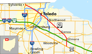
State Route 795 is an east–west state highway in northwestern Ohio, a U.S. state. The western terminus of SR 795 is at US 20 in Perrysburg, at the signalized intersection that doubles as the northern terminus of SR 199. Its eastern terminus is at a signalized intersection with SR 51 about 0.5 miles (0.80 km) southeast of Millbury.

State Route 49 is a state highway in the western part of the U.S. state of Ohio. It begins in Drexel, an area within the city of Trotwood, at US 35 and runs northwesterly to Greenville, and then runs roughly along near the western edge of the state near the Indiana state line to the Michigan state line where it meets with Michigan's M-49.

State Route 109 (SR 109) is a 52.9-mile (85.1 km) state route that runs between Ottawa and the Michigan state line in the US state of Ohio. It crosses a major river, the Maumee, east of Napoleon. Most of the route is a rural two-lane highway and passes through both farmland and residential properties.

State Route 424 was an east–west state highway in the northwestern portion of the U.S. state of Ohio. The route was a former section of US 24 that ran parallel to the Maumee River and Miami and Erie Canal between the cities of Defiance and Napoleon. First designated in 1964, the western terminus of the route for most of its history was at an intersection with US 24 west of Defiance, though between 2008 and when the route was fully removed from the state highway system in 2012, it was at the Defiance County/Henry County line. Its eastern terminus was at a dead end near the US 6 / US 24 interchange east of Napoleon.

U.S. Route 20A (US 20A) is a 52.4-mile-long (84.3 km) east–west alternate route of US 20 located in northwest Ohio. The western terminus of the route is at US 20 southwest of Pioneer, and the eastern terminus is at US 20 in Maumee, southwest of Toledo.

State Route 110 (SR 110) is a 10.73-mile (17.27 km) state route that runs between Napoleon and north of McClure in the US state of Ohio. Most of the route is a rural two-lane highway and passes through both farmland and commercial properties. For much of its path, SR 110 runs generally parallel to the south of the Maumee River.

U.S. Route 24 (US 24) is a United States Numbered Highway that runs from Minturn, Colorado, to Independence Township, Michigan. In Ohio, it is an expressway and freeway for much of its length, from the Indiana state line to Maumee. From there northeast to the Michigan state line at Toledo, it is a surface highway.
U.S. Route 23 (US 23) is a United States Numbered Highway that runs from Jacksonville, Florida, to Mackinaw City, Michigan. In the state of Ohio, it is a major north–south state highway that runs from the Kentucky border at Portsmouth to the Michigan border at Sylvania.