Clinton County, Ohio

Last updated

Clinton County
Commercial Buildings -- Wilmington, Ohio.jpg
The Wilmington Commercial Historic District is on the National Register of Historic Places listings in Clinton County
Flag of Clinton County, Ohio.png
Seal of Clinton County Ohio.svg
Map of Ohio highlighting Clinton County.svg
Location within the U.S. state of Ohio
Ohio in United States.svg
Ohio's location within the U.S.
Coordinates: 39°24′54″N83°48′30″W / 39.41498°N 83.80838°W / 39.41498; -83.80838
CountryFlag of the United States.svg United States
StateFlag of Ohio.svg  Ohio
FoundedMarch 1, 1810 [1]
Named for George Clinton
Seat Wilmington
Largest cityWilmington
Area
  Total412 sq mi (1,070 km2)
  Land409 sq mi (1,060 km2)
  Water3.6 sq mi (9 km2)  0.9%
Population
 (2020)
  Total42,018 Decrease2.svg
  Density102.7/sq mi (39.7/km2)
Time zone UTC−5 (Eastern)
  Summer (DST) UTC−4 (EDT)
Congressional district 2nd
Website co.clinton.oh.us

Clinton County is a county located in the U.S. state of Ohio. As of the 2020 census, the population was 42,018. [2] Its county seat and largest city is Wilmington. [3] The county is named for former U.S. Vice President George Clinton. [4] Clinton County comprises the Wilmington, Ohio Micropolitan Statistical Area, which is also included in the Cincinnati-Wilmington-Maysville, OH-KY-IN Combined Statistical Area.

Contents

History

Clinton County was formed on February 19, 1810, from sections of Highland County and Warren County, with the law creating the county taking effect on March 1 of that year. It was named after George Clinton, a soldier, politician, Governor of New York, and Vice President of the United States.

Geography

According to the U.S. Census Bureau, the county has a total area of 412 square miles (1,070 km2), of which 409 square miles (1,060 km2) is land and 3.6 square miles (9.3 km2) (0.9%) is water. [5]

The entire county lies within the Little Miami River watershed, with the exception of extreme eastern areas, which are within the Scioto River watershed. Clinton County lies within the till plains physiographic region, and is somewhat flat or gently rolling. The northern two thirds of the county were covered with an ice sheet during the Wisconsinan Stage, while the southern third was covered by ice sheets during the much older Illinoian Stage. Because of such a history with ice, glacial features are readily found on the landscape, such as moraines and kames.

The general elevation of the county is roughly 1,050 feet (320 m) above sea level, and there are few areas in the county that deviate from this by more than 200 feet (61 m).

The climate of Clinton County can be classified as humid continental. It is one of the coolest and wettest counties in southern Ohio, although differences between it and other southern Ohio counties are usually very slight. Clinton County averages 42 inches (1.1 m) of precipitation per year, including 30 inches (0.76 m) of snow (Note: one inch of snow does not equal one inch of precipitation). Average July high temperatures reach the mid and upper 80s F although temperatures above 90 F are common, while lows are typically in the 60s F. January high temperatures typically reach the low and mid 30s F, while lows generally bottom out in the 10s F, although lows in the single digits and even below 0 °F or −17.8 °C are common.

Adjacent counties

Demographics

Historical population
CensusPop.Note
1810 2,674
1820 8,085202.4%
1830 11,43641.4%
1840 15,71937.5%
1850 18,83819.8%
1860 21,46113.9%
1870 21,9142.1%
1880 24,75613.0%
1890 24,240−2.1%
1900 24,202−0.2%
1910 23,680−2.2%
1920 23,036−2.7%
1930 21,547−6.5%
1940 22,5744.8%
1950 25,57213.3%
1960 30,00417.3%
1970 31,4644.9%
1980 34,60310.0%
1990 35,4152.3%
2000 40,54314.5%
2010 42,0403.7%
2020 42,018−0.1%
U.S. Decennial Census [6]
1790-1960 [7] 1900-1990 [8]
1990-2000 [9] 2020 [2]

2010 census

As of the 2010 United States Census, there were 42,040 people, 16,210 households, and 11,364 families living in the county. [10] The population density was 102.9 inhabitants per square mile (39.7/km2). There were 18,133 housing units at an average density of 44.4 per square mile (17.1/km2). [11] The racial makeup of the county was 94.7% white, 2.2% black or African American, 0.5% Asian, 0.2% American Indian, 0.5% from other races, and 1.9% from two or more races. Those of Hispanic or Latino origin made up 1.3% of the population. [10] In terms of ancestry, 26.4% were German, 15.4% were Irish, 12.0% were American, and 11.9% were English. [12]

Of the 16,210 households, 33.5% had children under the age of 18 living with them, 52.9% were married couples living together, 11.9% had a female householder with no husband present, 29.9% were non-families, and 25.1% of all households were made up of individuals. The average household size was 2.52 and the average family size was 2.99. The median age was 38.7 years. [10]

The median income for a household in the county was $46,261 and the median income for a family was $56,208. Males had a median income of $42,134 versus $31,380 for females. The per capita income for the county was $22,163. About 11.2% of families and 14.0% of the population were below the poverty line, including 18.6% of those under age 18 and 7.9% of those age 65 or over. [13]

2000 census

As of the census of 2000, there were 40,543 people, 15,416 households, and 11,068 families living in the county. The population density was 99 people per square mile (38 people/km2). There were 16,577 housing units at an average density of 40 per square mile (15/km2). The racial makeup of the county was 95.99% White, 2.19% Black or African American, 0.26% Native American, 0.38% Asian, 0.20% from other races, and 0.97% from two or more races. 0.66% of the population were Hispanic or Latino of any race. 29.3% were of American, 22.2% German, 12.1% English and 10.9% Irish ancestry according to 2000 census.

In 2005 94.7% of the county's population was non-Hispanic whites. Latinos were 1.3% of the population.

There were 15,416 households, out of which 34.70% had children under the age of 18 living with them, 57.40% were married couples living together, 10.10% had a female householder with no husband present, and 28.20% were non-families. 23.70% of all households were made up of individuals, and 9.90% had someone living alone who was 65 years of age or older. The average household size was 2.56 and the average family size was 3.03.

In the county, the population was spread out, with 26.40% under the age of 18, 10.20% from 18 to 24, 29.10% from 25 to 44, 22.10% from 45 to 64, and 12.20% who were 65 years of age or older. The median age was 35 years. For every 100 females there were 96.10 males. For every 100 females age 18 and over, there were 92.70 males.

The median income for a household in the county was $40,467, and the median income for a family was $48,158. Males had a median income of $34,448 versus $23,846 for females. The per capita income for the county was $18,462. About 6.40% of families and 8.60% of the population were below the poverty line, including 9.90% of those under age 18 and 11.60% of those age 65 or over.

Politics

Clinton County is a strongly Republican county. Since 1856, the only Democrat to win a majority in the county has been Lyndon Johnson in 1964, and he did so by only 432 votes.

United States presidential election results for Clinton County, Ohio [14]
Year Republican Democratic Third party
No.%No.%No.%
2020 15,48875.32%4,69722.84%3781.84%
2016 13,83873.74%4,06621.67%8624.59%
2012 12,00966.05%5,79131.85%3832.11%
2008 12,40964.16%6,55833.91%3751.94%
2004 12,93870.26%5,41729.42%590.32%
2000 9,82465.19%4,79131.79%4553.02%
1996 7,50451.68%5,30336.52%1,71411.80%
1992 7,29047.37%4,63830.13%3,46322.50%
1988 8,85669.74%3,74629.50%970.76%
1984 9,60373.77%3,33225.60%830.64%
1980 7,67561.90%3,96731.99%7586.11%
1976 6,59756.21%4,95942.25%1811.54%
1972 8,14074.08%2,70924.65%1391.27%
1968 6,26556.56%2,98226.92%1,83016.52%
1964 6,08248.29%6,51451.71%00.00%
1960 8,46465.30%4,49834.70%00.00%
1956 7,91970.07%3,38229.93%00.00%
1952 8,19167.83%3,88532.17%00.00%
1948 6,00961.32%3,75838.35%320.33%
1944 7,20065.98%3,71334.02%00.00%
1940 7,02758.60%4,96441.40%00.00%
1936 6,26551.66%5,78547.70%770.63%
1932 5,95352.37%5,25246.20%1631.43%
1928 7,15072.98%2,60326.57%440.45%
1924 5,95467.08%2,49628.12%4264.80%
1920 6,94765.61%3,59833.98%430.41%
1916 3,52056.58%2,60241.83%991.59%
1912 2,91648.68%2,01033.56%1,06417.76%
1908 4,10761.45%2,46436.87%1121.68%
1904 3,93765.79%1,82630.51%2213.69%
1900 4,14962.09%2,39435.83%1392.08%
1896 4,14460.18%2,65738.59%851.23%
1892 3,49158.88%2,07635.01%3626.11%
1888 3,81659.53%2,30535.96%2894.51%
1884 3,86461.21%2,28436.18%1652.61%
1880 3,93764.29%2,16735.39%200.33%
1876 3,50062.30%2,04836.45%701.25%
1872 3,10562.65%1,78636.04%651.31%
1868 2,92264.92%1,57935.08%00.00%
1864 2,77166.55%1,39333.45%00.00%
1860 2,48361.58%1,46436.31%852.11%
1856 2,11760.02%1,17033.17%2406.80%

Government

The Clinton County Courthouse was built in 1915 in Wilmington. The courthouse is located at 53 E. Main Street.

The Wilmington Public Library of Clinton County serves the communities of Clinton County from its administrative offices and main library in Wilmington and its Clinton-Massie branch in Clarksville. In 2005, the library loaned more than 161,000 items to its 17,000 cardholders. Total holdings as of 2005 were over 64,000 volumes with over 90 periodical subscriptions. [15]

Education

The following school districts have territory in Clinton County. Those primarily in Clinton are in bold, those primarily in other counties are in italics. The county a district is primarily located in is bolded.

Recreation

Clinton County is home to Cowan Lake State Park, where outdoor recreationalists enjoy fishing, swimming, boating, hiking, bicycling, camping, and wildlife viewing. The northwestern border of Clinton County is formed by Caesar Creek Lake, which is part of Caesar Creek State Park. Fossil hunting is popular here, in addition to similar activities enjoyed at Cowan Lake. Wilmington College in Wilmington has several NCAA Division III athletic programs, whose events can be attended by the public. The city is also the home of the Clinton County Corn Festival.

Transportation

Interstate 71 crosses the northern third of the county, trending northeast to southwest and connecting Clinton County to Columbus, Ohio and Cincinnati. Clinton County is part of the Cincinnati-Middletown-Wilmington Combined Statistical Area, although there is little true urban activity in the county. U.S. Route 68 is the major north–south route through the county, while U.S. Route 22 runs east–west. Several other state and local highways serve the residents of Clinton County. Clinton Field is a public use airport located four nautical miles (7 km) northwest of the central business district of Wilmington.

Communities

Map of Clinton County, Ohio With Municipal and Township Labels Map of Clinton County Ohio With Municipal and Township Labels.PNG
Map of Clinton County, Ohio With Municipal and Township Labels

City

Villages

Townships

Unincorporated communities

Ghost town

See also

Related Research Articles

<span class="mw-page-title-main">Montgomery County, Ohio</span> County in Ohio, United States

Montgomery County is in the southwestern part of the U.S. state of Ohio. At the 2020 census, the population was 537,309, making it the fifth-most populous county in Ohio. The county seat is Dayton. The county was named in honor of Richard Montgomery, an American Revolutionary War general, who was killed in 1775 while attempting to capture Quebec City, Canada. Montgomery County is part of the Dayton, Ohio, Metropolitan Statistical Area.

<span class="mw-page-title-main">Muskingum County, Ohio</span> County in Ohio, United States

Muskingum County is a county located in the U.S. state of Ohio. As of the 2020 census, the population was 86,410. Its county seat is Zanesville. Nearly bisected by the Muskingum River, the county name is based on a Delaware American Indian word translated as "town by the river" or "elk's eye". Muskingum County comprises the Zanesville, OH Micropolitan Statistical Area, which is also included in the Columbus-Marion-Zanesville, OH Combined Statistical Area. The Zanesville Micropolitan Statistical Area is the second-largest statistical area within the Combined Statistical Area, after the Columbus Metropolitan Statistical Area.

<span class="mw-page-title-main">Marion County, Ohio</span> County in Ohio, United States

Marion County is a county located in the U.S. state of Ohio. As of the 2020 census, the population was 65,359. Its county seat is Marion. The county was created in 1820 and later organized in 1824. It is named for General Francis "The Swamp Fox" Marion, a South Carolinian officer in the Revolutionary War.

<span class="mw-page-title-main">Highland County, Ohio</span> County in Ohio, United States

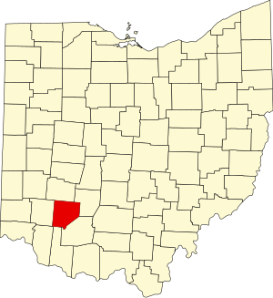
Highland County is a county located in the U.S. state of Ohio. As of the 2020 census, the population was 43,317. Its county seat is Hillsboro. The county is named for the topography which is hilly and divides the watersheds of the Little Miami and Scioto Rivers.

<span class="mw-page-title-main">Greene County, Ohio</span> County in Ohio, United States

Greene County is located in the southwestern portion of Ohio. As of the 2020 census, the population was 167,966. Its county seat is Xenia and its largest city is Beavercreek. The county was established on March 24, 1803 and named for General Nathanael Greene, an officer in the Revolutionary War. Greene County is part of the Dayton, OH Metropolitan Statistical Area.

<span class="mw-page-title-main">Fayette County, Ohio</span> County in Ohio, United States

Fayette County is a county located in the U.S. state of Ohio. As of the 2020 census, the population was 28,951. Its county seat and largest city is Washington Court House. The county was named for the Marquis de Lafayette, a Frenchman who was an officer in the American Army in the Revolution, when established on March 1, 1810.

<span class="mw-page-title-main">Clark County, Ohio</span> County in Ohio, United States

Clark County is a county located in the west central portion of the U.S. state of Ohio. As of the 2020 census, the population was 136,001. Its county seat and largest city is Springfield. The county was created on March 1, 1818, and was named for General George Rogers Clark, a hero of the American Revolution.

<span class="mw-page-title-main">Clarksville, Ohio</span> Village in Ohio, United States

Clarksville is a village in Clinton County, Ohio, United States. The population was 534 at the 2020 census. It is served by the Clinton Massie branch of the Wilmington Public Library of Clinton County.

<span class="mw-page-title-main">Sabina, Ohio</span> Village in Ohio, United States

Sabina is a village in Clinton County, Ohio, United States. As of the 2020 census, the village had a total population of 2,499.

<span class="mw-page-title-main">Highland Heights, Ohio</span> City in Ohio, United States

Highland Heights is a city in Cuyahoga County, Ohio, United States. The city's population was 8,719 as of the 2020 census. An eastern suburb of Cleveland, it is part of the Cleveland metropolitan area.

<span class="mw-page-title-main">Richmond Heights, Ohio</span> City in Ohio, United States

Richmond Heights is a city in Cuyahoga County, Ohio, United States. The population was 10,801 at the 2020 census. A suburb of Cleveland, it is part of the Cleveland metropolitan area.

<span class="mw-page-title-main">Cedarville, Ohio</span> Village in Ohio, United States

Cedarville is a village in Greene County, Ohio, United States. The village is within the Dayton Metropolitan Statistical Area. The population was 4,257 at the 2020 census.

<span class="mw-page-title-main">Jamestown, Ohio</span> Village in Ohio, United States

Jamestown is a village in Greene County, Ohio, United States. The population was 2,052 at the 2020 census.

<span class="mw-page-title-main">Hillsboro, Ohio</span> City in Ohio, United States

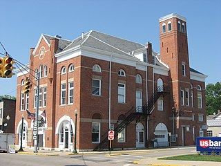
Hillsboro is a city in and the county seat of Highland County, Ohio, United States, approximately 35 miles (56 km) west of Chillicothe and 50 miles (80 km) east of Cincinnati. The population was 6,481 at the 2020 census.

<span class="mw-page-title-main">Leesburg, Ohio</span> Village in Ohio, United States

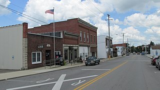
Leesburg is a village in Highland County, Ohio, United States. The population was 1,273 at the 2020 census.

<span class="mw-page-title-main">Riverside, Ohio</span> City in Ohio, United States

Riverside is a city in Montgomery County, Ohio, United States. The population was 24,474 at the 2020 census. A suburb of Dayton, it is part of the Dayton metropolitan area.

<span class="mw-page-title-main">Port Clinton, Ohio</span> City in Ohio, United States

Port Clinton is a city in and the county seat of Ottawa County, Ohio, United States, located at the mouth of the Portage River on Lake Erie. The population was 6,025 at the 2020 census. It is the principal city of the Port Clinton micropolitan area, about 34 miles (55 km) southeast of Toledo.

<span class="mw-page-title-main">New Franklin, Ohio</span> City in Ohio, United States

New Franklin is a city in southwestern Summit County, Ohio, United States, in the northeastern part of the state. The population was 13,877 according to the 2020 census. It is part of the Akron metropolitan area.

<span class="mw-page-title-main">Blanchester, Ohio</span> Village in Ohio, United States

Blanchester is a village in Clinton and Warren counties in the U.S. state of Ohio. The population was 4,224 at the 2020 census. Blanchester is part of the Wilmington, Ohio Micropolitan Statistical Area, which is also included in the Cincinnati-Wilmington-Maysville, OH-KY-IN Combined Statistical Area.

<span class="mw-page-title-main">Lynchburg, Ohio</span> Village in Ohio, United States

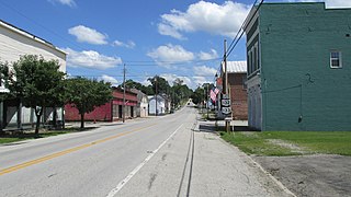
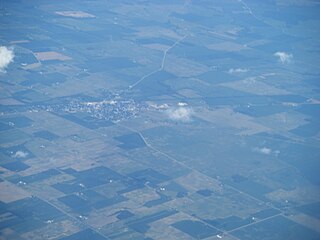
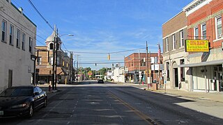
Lynchburg is a village in Clinton and Highland counties in the U.S. state of Ohio. The population was 1,510 at the 2020 census.

References

  1. "Ohio County Profiles: Clinton County" (PDF). Ohio Department of Development. Archived from the original (PDF) on June 21, 2007. Retrieved April 28, 2007.
  2. 1 2 2020 census
  3. "Find a County". National Association of Counties. Archived from the original on May 31, 2011. Retrieved June 7, 2011.
  4. Taylor, William Alexander (1899). Ohio Statesmen and Annals of Progress. Press of the Westbote Company. pp.  244.
  5. "2010 Census Gazetteer Files". United States Census Bureau. August 22, 2012. Archived from the original on May 4, 2014. Retrieved February 7, 2015.
  6. "U.S. Decennial Census". United States Census Bureau. Retrieved February 7, 2015.
  7. "Historical Census Browser". University of Virginia Library. Archived from the original on August 11, 2012. Retrieved February 7, 2015.
  8. Forstall, Richard L., ed. (March 27, 1995). "Population of Counties by Decennial Census: 1900 to 1990". United States Census Bureau. Retrieved February 7, 2015.
  9. "Census 2000 PHC-T-4. Ranking Tables for Counties: 1990 and 2000" (PDF). United States Census Bureau. April 2, 2001. Retrieved February 7, 2015.
  10. 1 2 3 "DP-1 Profile of General Population and Housing Characteristics: 2010 Demographic Profile Data". United States Census Bureau. Archived from the original on February 13, 2020. Retrieved December 27, 2015.
  11. "Population, Housing Units, Area, and Density: 2010 - County". United States Census Bureau. Archived from the original on February 13, 2020. Retrieved December 27, 2015.
  12. "DP02 SELECTED SOCIAL CHARACTERISTICS IN THE UNITED STATES – 2006-2010 American Community Survey 5-Year Estimates". United States Census Bureau. Archived from the original on February 13, 2020. Retrieved December 27, 2015.
  13. "DP03 SELECTED ECONOMIC CHARACTERISTICS – 2006-2010 American Community Survey 5-Year Estimates". United States Census Bureau. Archived from the original on February 13, 2020. Retrieved December 27, 2015.
  14. Leip, David. "Dave Leip's Atlas of U.S. Presidential Elections". uselectionatlas.org. Retrieved May 1, 2018.
  15. "2005 Ohio Public Library Statistics:Statistics by County and Town". State Library of Ohio. Archived from the original on September 24, 2006. Retrieved October 3, 2006.

39°24′54″N83°48′30″W / 39.41498°N 83.80838°W / 39.41498; -83.80838