Clarksville, Ohio

Last updated

Clarksville, Ohio
Clarksville2.JPG
Looking east on Main Street (Ohio State Route 350) in Clarksville
OHMap-doton-Clarksville.png
Location of Clarksville, Ohio
Map of Clinton County Ohio Highlighting Clarksville Village.png
Location of Clarksville in Clinton County
Coordinates: 39°24′06″N83°58′59″W / 39.40167°N 83.98306°W / 39.40167; -83.98306
Country United States
State Ohio
County Clinton
Area
[1]
  Total0.50 sq mi (1.28 km2)
  Land0.47 sq mi (1.21 km2)
  Water0.03 sq mi (0.07 km2)
Elevation
[2]
814 ft (248 m)
Population
 (2020)
  Total534
  Density1,145.92/sq mi (442.84/km2)
Time zone UTC-5 (Eastern (EST))
  Summer (DST) UTC-4 (EDT)
ZIP code
45113
Area code(s) 937, 326
FIPS code 39-15406 [3]
GNIS feature ID2397633 [2]

Clarksville is a village in Clinton County, Ohio, United States. The population was 534 at the 2020 census. It is served by the Clinton Massie branch of the Wilmington Public Library of Clinton County. [4]

Contents

History

Clarksville was laid out in 1816. [5] The village was named after Sarah Clark Hadley, the wife of an early settler. [6]

Geography

According to the United States Census Bureau, the village has a total area of 0.49 square miles (1.27 km2), of which 0.46 square miles (1.19 km2) is land and 0.03 square miles (0.08 km2) is water. [7]

Demographics

Historical population
CensusPop.Note
1870 389
1880 367−5.7%
1890 339−7.6%
1900 46537.2%
1910 425−8.6%
1920 410−3.5%
1930 401−2.2%
1940 4307.2%
1950 51018.6%
1960 58314.3%
1970 574−1.5%
1980 525−8.5%
1990 485−7.6%
2000 4972.5%
2010 54810.3%
2020 534−2.6%
U.S. Decennial Census [8]

2010 census

As of the census [9] of 2010, there were 548 people, 204 households, and 145 families living in the village. The population density was 1,191.3 inhabitants per square mile (460.0/km2). There were 238 housing units at an average density of 517.4 per square mile (199.8/km2). The racial makeup of the village was 96.0% White, 0.2% Native American, 2.2% Asian, 0.9% from other races, and 0.7% from two or more races. Hispanic or Latino of any race were 0.9% of the population.

There were 204 households, of which 42.2% had children under the age of 18 living with them, 43.6% were married couples living together, 16.2% had a female householder with no husband present, 11.3% had a male householder with no wife present, and 28.9% were non-families. 22.1% of all households were made up of individuals, and 7.4% had someone living alone who was 65 years of age or older. The average household size was 2.69 and the average family size was 3.12.

The median age in the village was 31.5 years. 31.4% of residents were under the age of 18; 8.3% were between the ages of 18 and 24; 28.4% were from 25 to 44; 24.5% were from 45 to 64; and 7.3% were 65 years of age or older. The gender makeup of the village was 51.3% male and 48.7% female.

2000 census

As of the census [3] of 2000, there were 497 people, 191 households, and 136 families living in the village. The population density was 1,023.7 inhabitants per square mile (395.3/km2). There were 216 housing units at an average density of 444.9 per square mile (171.8/km2). The racial makeup of the village was 96.58% White, 0.40% African American, 1.01% Native American, 0.20% Asian, 0.20% from other races, and 1.61% from two or more races. Hispanic or Latino of any race were 1.01% of the population.

There were 191 households, out of which 40.3% had children under the age of 18 living with them, 51.8% were married couples living together, 13.1% had a female householder with no husband present, and 28.3% were non-families. 22.5% of all households were made up of individuals, and 6.3% had someone living alone who was 65 years of age or older. The average household size was 2.60 and the average family size was 3.02.

In the village, the population was spread out, with 28.2% under the age of 18, 9.7% from 18 to 24, 33.8% from 25 to 44, 18.3% from 45 to 64, and 10.1% who were 65 years of age or older. The median age was 31 years. For every 100 females there were 89.7 males. For every 100 females age 18 and over, there were 89.9 males.

The median income for a household in the village was $32,250, and the median income for a family was $39,375. Males had a median income of $31,875 versus $21,328 for females. The per capita income for the village was $14,448. About 6.2% of families and 9.0% of the population were below the poverty line, including 7.3% of those under age 18 and 8.3% of those age 65 or over.

Clarksville corporation limit sign ClarksvilleOhio1.JPG
Clarksville corporation limit sign

Notable people

Related Research Articles

<span class="mw-page-title-main">Clinton County, Ohio</span> County in Ohio, United States

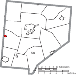
Clinton County is a county located in the U.S. state of Ohio. As of the 2020 census, the population was 42,018. Its county seat and largest city is Wilmington. The county is named for former U.S. Vice President George Clinton. Clinton County comprises the Wilmington, Ohio Micropolitan Statistical Area, which is also included in the Cincinnati-Wilmington-Maysville, OH-KY-IN Combined Statistical Area.

<span class="mw-page-title-main">Perry County, Ohio</span> County in Ohio, United States

Perry County is a county located in the U.S. state of Ohio. As of the 2020 census, the population was 35,408. Its county seat is New Lexington. It was established on March 1, 1818, from parts of Fairfield, Washington and Muskingum counties. The county is named for Oliver Hazard Perry, a hero of the War of 1812. Perry County is included in the Columbus, OH Metropolitan Statistical Area. One of the poorest counties in the state, this is where the lawsuit challenging Ohio's school funding system, DeRolph v. State, began.

<span class="mw-page-title-main">Clinton, Lenawee County, Michigan</span> Village in Michigan, United States

Clinton is a village in Lenawee County in the Irish Hills area of the U.S. state of Michigan. The population was 2,336 at the 2010 census. The village is located within Clinton Township.

<span class="mw-page-title-main">Aberdeen, Ohio</span> Village in Ohio, United States

Aberdeen is a village in Huntington Township, Brown County, Ohio, United States, along the Ohio River 50 miles (80 km) southeast of Cincinnati. The population was 1,515 at the 2020 census.

<span class="mw-page-title-main">Martinsville, Ohio</span> Village in Ohio, United States

Martinsville is a village in Clinton County, Ohio, United States. The population was 416 at the 2020 census.

<span class="mw-page-title-main">Midland, Ohio</span> Village in Ohio, United States

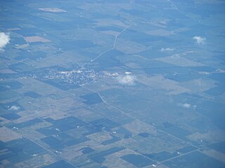
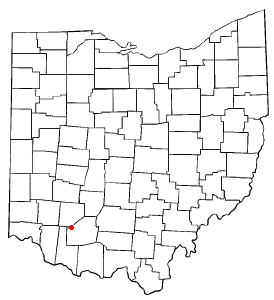
Midland is a village in Clinton County, Ohio, United States. The population was 307 at the 2020 census.

<span class="mw-page-title-main">New Vienna, Ohio</span> Village in Ohio, United States

New Vienna is a village in Clinton County, Ohio, United States. The population was 1,108 at the 2020 census.

<span class="mw-page-title-main">Port William, Ohio</span> Village in Ohio, United States

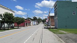
Port William is a village in Clinton County, Ohio, United States. The population was 229 at the 2020 census.

<span class="mw-page-title-main">Sabina, Ohio</span> Village in Ohio, United States

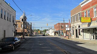
Sabina is a village in Clinton County, Ohio, United States. As of the 2020 census, the village had a total population of 2,499.

<span class="mw-page-title-main">Warsaw, Ohio</span> Village in Ohio, United States

Warsaw is a village in Coshocton County, Ohio, United States, along the Walhonding River. The population was 624 at the 2020 census.

<span class="mw-page-title-main">Brice, Ohio</span> Village in Ohio, United States

Brice is a village in Franklin County, Ohio, United States, on the southeast side of the Columbus metropolitan area. The population was 93 at the 2020 census.

<span class="mw-page-title-main">Addyston, Ohio</span> Village in Ohio, United States

Addyston is a village in Miami Township, Hamilton County, Ohio, United States. Located along the Ohio River, it is a western suburb of the neighboring city of Cincinnati. The population was 927 at the 2020 census.

<span class="mw-page-title-main">Cleves, Ohio</span> City in Ohio, United States

Cleves is a village in Miami Township, Hamilton County, Ohio, United States. Located along the Ohio River, it is a western suburb of Cincinnati. The population was 3,414 at the 2020 census.

<span class="mw-page-title-main">Evendale, Ohio</span> Village in Ohio, United States

Evendale is a village in Hamilton County, Ohio, United States, within the Cincinnati metropolitan area. The population was 2,669 at the 2020 census.

<span class="mw-page-title-main">Clinton, Ohio</span> Village in Ohio, United States

Clinton is a village in southwestern Summit County, Ohio, United States. The population was 1,197 at the 2020 Census. It is part of the Akron metropolitan area.

<span class="mw-page-title-main">Harveysburg, Ohio</span> Village in Ohio, United States

Harveysburg is a village in Massie Township, Warren County, Ohio, United States. The population was 554 at the 2020 census. It is best known as the home of the Ohio Renaissance Festival.

<span class="mw-page-title-main">Shreve, Ohio</span> Village in Ohio, United States

Shreve is a village in Clinton Township, Wayne County, Ohio, United States. The population was 1,497 at the 2020 census. Shreve is served by a branch of the Wayne County Public Library.

<span class="mw-page-title-main">Blanchester, Ohio</span> Village in Ohio, United States

Blanchester is a village in Clinton and Warren counties in the U.S. state of Ohio. The population was 4,224 at the 2020 census. Blanchester is part of the Wilmington, Ohio Micropolitan Statistical Area, which is also included in the Cincinnati-Wilmington-Maysville, OH-KY-IN Combined Statistical Area.

<span class="mw-page-title-main">Lynchburg, Ohio</span> Village in Ohio, United States

Lynchburg is a village in Clinton and Highland counties in the U.S. state of Ohio. The population was 1,510 at the 2020 census.

<span class="mw-page-title-main">Gratiot, Ohio</span> Village in Ohio, United States

Gratiot is a village in Licking and Muskingum counties in the U.S. state of Ohio. The population was 215 at the 2020 census.

References

  1. "ArcGIS REST Services Directory". United States Census Bureau. Retrieved September 20, 2022.
  2. 1 2 U.S. Geological Survey Geographic Names Information System: Clarksville, Ohio
  3. 1 2 "U.S. Census website". United States Census Bureau . Retrieved January 31, 2008.
  4. "Locations & Hours". Wilmington Public Library. Retrieved February 25, 2018.
  5. Brown, Albert J. (1915). History of Clinton County, Ohio: Its People, Industries, and Institutions. B.F. Bowen. pp.  309.
  6. Overman, William Daniel (1958). Ohio Town Names. Akron, OH: Atlantic Press. p. 29.
  7. "US Gazetteer files 2010". United States Census Bureau. Archived from the original on January 25, 2012. Retrieved January 6, 2013.
  8. "Census of Population and Housing". Census.gov. Retrieved June 4, 2015.
  9. "U.S. Census website". United States Census Bureau . Retrieved January 6, 2013.