Henry County, Ohio

Last updated

Henry County
Henry County Courthouse -- Napoleon, Ohio (cropped).jpg
Flag of Henry County, Ohio.png
Seal of Henry County Ohio.svg
Map of Ohio highlighting Henry County.svg
Location within the U.S. state of Ohio
Ohio in United States.svg
Ohio's location within the U.S.
Coordinates: 41°20′N84°04′W / 41.33°N 84.07°W / 41.33; -84.07
CountryFlag of the United States.svg United States
StateFlag of Ohio.svg  Ohio
FoundedDecember 26, 1834
Named for Patrick Henry
Seat Napoleon
Largest cityNapoleon
Area
  Total420 sq mi (1,100 km2)
  Land416 sq mi (1,080 km2)
  Water3.7 sq mi (10 km2)  0.9%
Population
 (2020)
  Total27,662
  Density66/sq mi (25/km2)
Time zone UTC−5 (Eastern)
  Summer (DST) UTC−4 (EDT)
Congressional district 5th
Website www.henrycountyohio.gov

Henry County is a county located in the U.S. state of Ohio. As of the 2020 census, the population was 27,662. [1] Its county seat is Napoleon. [2] The county was created in 1820 and later organized in 1834. [3] It is named for American Founding Father Patrick Henry, the Virginian famous for his "give me liberty, or give me death!" speech. [4]

Contents

Geography

According to the U.S. Census Bureau, the county has a total area of 420 square miles (1,100 km2), of which 416 square miles (1,080 km2) is land and 3.7 square miles (9.6 km2) (0.9%) is water. [5]

Adjacent counties

Demographics

Historical population
CensusPop.Note
1830 262
1840 2,503855.3%
1850 3,43437.2%
1860 8,901159.2%
1870 14,02857.6%
1880 20,58546.7%
1890 25,08021.8%
1900 27,2828.8%
1910 25,119−7.9%
1920 23,362−7.0%
1930 22,524−3.6%
1940 22,7561.0%
1950 22,423−1.5%
1960 25,39213.2%
1970 27,0586.6%
1980 28,3834.9%
1990 29,1082.6%
2000 29,2100.4%
2010 28,215−3.4%
2020 27,662−2.0%
U.S. Decennial Census [6]
1790-1960 [7] 1900-1990 [8]
1990-2000 [9] 2020 [1]

2000 census

As of the census [10] of 2000, there were 29,210 people, 10,935 households, and 7,960 families living in the county. The population density was 70 people per square mile (27 people/km2). There were 11,622 housing units at an average density of 28 units per square mile (11/km2). The racial makeup of the county was 95.33% White, 0.58% Black or African American, 0.26% Native American, 0.42% Asian, 2.56% from other races, and 0.85% from two or more races. 5.40% of the population were Hispanic or Latino of any race. 94.3% spoke English, 3.7% Spanish and 1.7% German as their first language.

There were 10,935 households, out of which 35.20% had children under the age of 18 living with them, 61.10% were married couples living together, 8.10% had a female householder with no husband present, and 27.20% were non-families. 23.50% of all households were made up of individuals, and 10.40% had someone living alone who was 65 years of age or older. The average household size was 2.62 and the average family size was 3.10.

In the county, the population was spread out, with 27.60% under the age of 18, 8.20% from 18 to 24, 28.10% from 25 to 44, 22.10% from 45 to 64, and 14.00% who were 65 years of age or older. The median age was 36 years. For every 100 females there were 97.60 males. For every 100 females age 18 and over, there were 93.60 males.

The median income for a household in the county was $42,657, and the median income for a family was $49,881. Males had a median income of $35,901 versus $24,076 for females. The per capita income for the county was $18,667. About 5.30% of families and 7.00% of the population were below the poverty line, including 9.90% of those under age 18 and 4.20% of those age 65 or over.

2010 census

As of the 2010 United States Census, there were 28,215 people, 10,934 households, and 7,883 families living in the county. [11] The population density was 67.8 inhabitants per square mile (26.2/km2). There were 11,963 housing units at an average density of 28.8 units per square mile (11.1 units/km2). [12] The racial makeup of the county was 95.2% white, 0.4% black or African American, 0.4% Asian, 0.3% American Indian, 2.4% from other races, and 1.3% from two or more races. Those of Hispanic or Latino origin made up 6.6% of the population. [11] In terms of ancestry, 53.7% were German, 10.6% were Irish, 7.1% were English; 6.9% identified as "American". [13]

Of the 10,934 households, 33.3% had children under the age of 18 living with them, 58.2% were married couples living together, 9.3% had a female householder with no husband present, 27.9% were non-families, and 23.7% of all households were made up of individuals. The average household size was 2.55 and the average family size was 2.99. The median age was 39.8 years. [11]

The median income for a household in the county was $48,367 and the median income for a family was $58,587. Males had a median income of $44,953 versus $32,127 for females. The per capita income for the county was $22,638. About 8.0% of families and 10.6% of the population were below the poverty line, including 13.5% of those under age 18 and 5.9% of those age 65 or over. [14]

Politics

Prior to 1912, Henry County was a stronghold Democratic county in presidential elections. From 1912 to 1936, it was a bellwether county, but starting with the 1940 election, it has become a Republican stronghold with Lyndon B. Johnson in 1964 being the lone Democrat to win since then.

United States presidential election results for Henry County, Ohio [15]
Year Republican Democratic Third party
No.%No.%No.%
2020 10,47970.86%4,06227.47%2471.67%
2016 9,30166.19%3,75626.73%9967.09%
2012 8,25757.92%5,65839.69%3422.40%
2008 8,23955.47%6,32042.55%2931.97%
2004 9,90265.55%5,11133.84%920.61%
2000 8,53064.37%4,36732.95%3552.68%
1996 6,38549.94%4,76237.25%1,63812.81%
1992 6,19646.38%3,93329.44%3,23024.18%
1988 8,61869.12%3,76430.19%860.69%
1984 9,31776.54%2,77922.83%770.63%
1980 7,58466.01%3,05926.63%8467.36%
1976 7,65661.40%4,59236.82%2221.78%
1972 8,09970.58%3,14527.41%2312.01%
1968 6,97063.21%3,25629.53%8007.26%
1964 5,09446.57%5,84553.43%00.00%
1960 8,25170.73%3,41529.27%00.00%
1956 8,16474.63%2,77525.37%00.00%
1952 8,02972.73%3,01027.27%00.00%
1948 5,02457.59%3,68942.29%110.13%
1944 7,24173.54%2,60526.46%00.00%
1940 7,78468.93%3,50831.07%00.00%
1936 4,10838.51%5,47251.29%1,08810.20%
1932 3,06730.10%6,98768.58%1341.32%
1928 5,37059.29%3,64740.27%400.44%
1924 3,85545.51%2,92234.50%1,69319.99%
1920 5,73866.10%2,82932.59%1141.31%
1916 2,48242.33%3,25255.47%1292.20%
1912 80415.36%2,99457.20%1,43627.44%
1908 2,42537.81%3,81759.52%1712.67%
1904 2,70745.85%3,10252.54%951.61%
1900 2,62338.35%4,15760.77%600.88%
1896 2,55836.91%4,32362.37%500.72%
1892 1,98135.48%3,31259.32%2905.19%
1888 2,04735.29%3,58361.77%1712.95%
1884 1,98237.86%3,19661.05%571.09%
1880 1,73837.44%2,87161.85%330.71%
1876 1,52738.36%2,44561.42%90.23%
1872 1,16042.76%1,51055.66%431.58%
1868 1,15642.19%1,58457.81%00.00%
1864 83040.06%1,24259.94%00.00%
1860 80843.60%1,03956.07%60.32%
1856 58746.44%65551.82%221.74%

Government

Henry County has a three-member Board of County Commissioners that oversee the various county departments, similar to 85 of the other 88 Ohio counties. The county commissioners are Lori Siclair, Glenn Miller, and Robert Hastedt. [16]

Transportation

Airport

Henry County Airport is a public use airport located 3 nautical miles (6 km) east of the central business district of Napoleon, Ohio. It is owned by the Henry County Airport Authority. [17]

Communities

Map of Henry County, Ohio with Municipal and Township Labels Map of Henry County Ohio With Municipal and Township Labels.PNG
Map of Henry County, Ohio with Municipal and Township Labels

City

Villages

Townships

Census-designated place

Unincorporated communities

See also

Related Research Articles

<span class="mw-page-title-main">Williams County, Ohio</span> County in Ohio, United States

Williams County is a county located in the U.S. state of Ohio. As of the 2020 census, the population was 37,102. Its county seat is Bryan. The county was created in 1820 and later organized in 1824. It is named for David Williams, one of the captors of John André in the American Revolutionary War.

<span class="mw-page-title-main">Pike County, Ohio</span> County in Ohio, United States

Pike County is a county located in the Appalachian (southern) region of the U.S. state of Ohio. As of the 2020 census, the population was 27,088. Its county seat is Waverly. The county is named for explorer Zebulon Pike.

<span class="mw-page-title-main">Jackson County, Ohio</span> County in Ohio, United States

Jackson County is a county located in the U.S. state of Ohio. As of the 2020 census, the population was 32,653. Its county seat is Jackson. The county is named for Andrew Jackson, a hero of the War of 1812 who was subsequently elected President of the United States. It is known as "The Little Wales of Ohio." Jackson County comprises the Jackson, OH Micropolitan Statistical Area.

<span class="mw-page-title-main">Harrison County, Ohio</span> County in Ohio, United States

Harrison County is a county located in the U.S. state of Ohio. As of the 2020 census, the population was 14,483, making it the fifth-least populous county in Ohio. Its county seat and largest village is Cadiz. The county is named for General William Henry Harrison, who was later President of the United States.

<span class="mw-page-title-main">Hancock County, Ohio</span> County in Ohio, United States

Hancock County is a county located in the U.S. state of Ohio. As of the 2020 census, the population was 74,920. Its county seat and largest city is Findlay. The county was created in 1820 and later organized in 1828. It was named for John Hancock, the first signer of the Declaration of Independence.

<span class="mw-page-title-main">Fulton County, Ohio</span> County in Ohio, United States

Fulton County is a county located in the U.S. state of Ohio west of Toledo. As of the 2020 census, the population was 42,713. Its county seat and largest city is Wauseon. The county was created in 1850 with land from Henry, Lucas, and Williams counties and is named for Robert Fulton, inventor of the steamboat. Fulton County is a part of the Toledo metropolitan area.

<span class="mw-page-title-main">Crawford County, Ohio</span> County in Ohio, United States

Crawford County is a county located in the north central portion of the U.S. state of Ohio. As of the 2020 census, the population was 42,025. Its county seat and largest city is Bucyrus. The county was created in 1820 and later organized in 1836. It was named for Colonel William Crawford, a soldier during the American Revolution. Crawford County comprises the Bucyrus, OH Micropolitan Statistical Area, which is also included in the Mansfield-Ashland-Bucyrus, OH Combined Statistical Area.

<span class="mw-page-title-main">Coshocton County, Ohio</span> County in Ohio, United States

Coshocton County is a county located in the U.S. state of Ohio. As of the 2020 census, the population was 36,612. Its county seat and largest city is Coshocton. The county lies within the Appalachian region of the state. The county was formed on January 31, 1810, from portions of Muskingum and Tuscarawas Counties and later organized in 1811. Its name comes from the Delaware Indian language and has been translated as "union of waters" or "black bear crossing". Coshocton was mentioned by David Zeisberger in his diary from the 1780s using the German spelling "Goschachgünk". The Coshocton, OH Micropolitan Statistical Area includes all of Coshocton County.

<span class="mw-page-title-main">Ashland County, Ohio</span> County in Ohio, United States

Ashland County is a county located in the northeastern portion of the U.S. state of Ohio. As of the 2020 census, the population was 52,447. Its county seat and largest city is Ashland. The county is named for "Ashland", the home of Senator Henry Clay near Lexington, Kentucky. It was formed in 1846 from parts of Huron, Lorain, Richland and Wayne Counties.

<span class="mw-page-title-main">Napoleon, Missouri</span> City in Missouri, United States

Napoleon is a city in Lafayette County, Missouri, and part of the Kansas City metropolitan area within the United States. It is located approximately 30 miles (48 km) east of Kansas City. The population was 222 at the 2010 census.

<span class="mw-page-title-main">Napoleon, North Dakota</span> City in North Dakota, United States

Napoleon is a city in Logan County, North Dakota, United States. It is the county seat of Logan County. The population was 749 at the 2020 census.

<span class="mw-page-title-main">Gordon, Ohio</span> Village in Ohio, United States

Gordon is a village in Darke County, Ohio, United States. The population was 245 at the 2020 census.

<span class="mw-page-title-main">Old Washington, Ohio</span> Village in Ohio, United States

Old Washington is a village in Guernsey County, Ohio, United States. The population was 223 at the 2020 census.

<span class="mw-page-title-main">North Bend, Ohio</span> Village in Ohio, United States

North Bend is a village in Miami Township, Hamilton County, Ohio, United States, along the Ohio River. It is a part of the Greater Cincinnati area. The population was 835 at the 2020 census.

<span class="mw-page-title-main">New Athens, Ohio</span> Village in Ohio, United States

New Athens is a village in Harrison County, Ohio, United States. The population was 222 at the 2020 census.

<span class="mw-page-title-main">Deshler, Ohio</span> Village in Ohio, United States

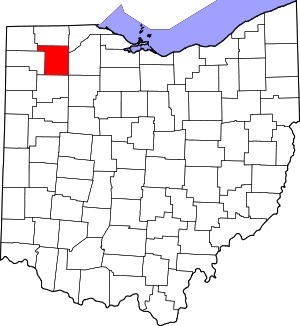
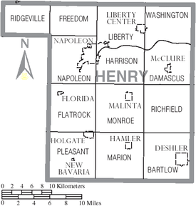
Deshler is a village in Henry County, Ohio, United States. The population was 1,588 at the 2020 census.

<span class="mw-page-title-main">Napoleon, Ohio</span> City in Ohio, United States

Napoleon is a city in and the county seat of Henry County, Ohio, United States, along the Maumee River 44 miles (71 km) southwest of Toledo. As of the 2020 census, the city had a total population of 8,862.

<span class="mw-page-title-main">Fultonham, Ohio</span> Village in Ohio, United States

Fultonham is a village in Muskingum County, Ohio, United States. The population was 115 at the 2020 census. It is part of the Zanesville micropolitan area. Fultonham was named for postmaster Robert Fulton.

<span class="mw-page-title-main">Kingston, Ohio</span> Village in Ohio, United States

Kingston is a village in Ross County, Ohio, United States. The population was 1,262 at the 2020 census.

<span class="mw-page-title-main">Bairdstown, Ohio</span> Village in Ohio, United States

Bairdstown is a village in Wood County, Ohio, United States. The population was 115 at the 2020 census.

References

  1. 1 2 2020 census
  2. "Find a County". National Association of Counties. Archived from the original on May 31, 2011. Retrieved June 7, 2011.
  3. "Ohio: Individual County Chronologies". Ohio Atlas of Historical County Boundaries. The Newberry Library. 2007. Archived from the original on April 6, 2016. Retrieved February 14, 2015.
  4. Gannett, Henry (1905). The Origin of Certain Place Names in the United States. Govt. Print. Off. pp.  155.
  5. "2010 Census Gazetteer Files". United States Census Bureau. August 22, 2012. Archived from the original on May 4, 2014. Retrieved February 8, 2015.
  6. "U.S. Decennial Census". United States Census Bureau. Retrieved February 8, 2015.
  7. "Historical Census Browser". University of Virginia Library. Retrieved February 8, 2015.
  8. Forstall, Richard L., ed. (March 27, 1995). "Population of Counties by Decennial Census: 1900 to 1990". United States Census Bureau. Retrieved February 8, 2015.
  9. "Census 2000 PHC-T-4. Ranking Tables for Counties: 1990 and 2000" (PDF). United States Census Bureau. April 2, 2001. Archived (PDF) from the original on March 27, 2010. Retrieved February 8, 2015.
  10. "U.S. Census website". United States Census Bureau . Retrieved January 31, 2008.
  11. 1 2 3 "DP-1 Profile of General Population and Housing Characteristics: 2010 Demographic Profile Data". United States Census Bureau. Archived from the original on February 13, 2020. Retrieved December 27, 2015.
  12. "Population, Housing Units, Area, and Density: 2010 - County". United States Census Bureau. Archived from the original on February 13, 2020. Retrieved December 27, 2015.
  13. "DP02 SELECTED SOCIAL CHARACTERISTICS IN THE UNITED STATES – 2006-2010 American Community Survey 5-Year Estimates". United States Census Bureau. Archived from the original on February 13, 2020. Retrieved December 27, 2015.
  14. "DP03 SELECTED ECONOMIC CHARACTERISTICS – 2006-2010 American Community Survey 5-Year Estimates". United States Census Bureau. Archived from the original on February 13, 2020. Retrieved December 27, 2015.
  15. Leip, David. "Dave Leip's Atlas of U.S. Presidential Elections". uselectionatlas.org. Retrieved May 2, 2018.
  16. "Board of County Commissioners". Henry County Ohio Homepage. Retrieved August 4, 2021.
  17. FAA Airport Form 5010 for 7W5 PDF . Federal Aviation Administration. Effective May 31, 2012.

41°20′N84°04′W / 41.33°N 84.07°W / 41.33; -84.07