Major General Arthur St. Clair was a Scottish-American soldier and politician. Born in Thurso, Scotland, he served in the British Army during the French and Indian War before settling in Pennsylvania, where he held local office. During the American Revolutionary War, he rose to the rank of major general in the Continental Army, but lost his command after a controversial retreat from Fort Ticonderoga.

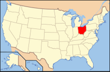
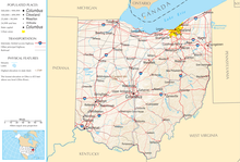
Ohio is a state in the Midwestern region of the United States. Ohio borders Lake Erie to the north, Pennsylvania to the east, West Virginia to the southeast, Kentucky to the southwest, Indiana to the west, and Michigan to the northwest. Of the 50 U.S. states, it is the 34th-largest by area. With a population of nearly 11.8 million, Ohio is the seventh-most populous and tenth-most densely populated state. Its capital and most populous city is Columbus, with other large population centers including Cleveland, Cincinnati, Dayton, Akron, and Toledo. Ohio is nicknamed the "Buckeye State" after its Ohio buckeye trees, and Ohioans are also known as "Buckeyes". Its flag is the only non-rectangular flag of all U.S. states.

The Northwest Ordinance, enacted July 13, 1787, was an organic act of the Congress of the Confederation of the United States. It created the Northwest Territory, the new nation's first organized incorporated territory, from lands beyond the Appalachian Mountains, between British North America and the Great Lakes to the north and the Ohio River to the south. The upper Mississippi River formed the territory's western boundary. Pennsylvania was the eastern boundary.

The Northwest Territory, also known as the Old Northwest and formally known as the Territory Northwest of the River Ohio, was formed from unorganized western territory of the United States after the American Revolution. Established in 1787 by the Congress of the Confederation through the Northwest Ordinance, it was the nation's first post-colonial organized incorporated territory.

The Treaty of Greenville, also known to Americans as the Treaty with the Wyandots, etc., but formally titled A treaty of peace between the United States of America, and the tribes of Indians called the Wyandots, Delawares, Shawanees, Ottawas, Chippewas, Pattawatimas, Miamis, Eel Rivers, Weas, Kickapoos, Piankeshaws, and Kaskaskias was a 1795 treaty between the United States and indigenous nations of the Northwest Territory, including the Wyandot and Delaware peoples, that redefined the boundary between indigenous peoples' lands and territory for European American community settlement.

The Territory of Michigan was an organized incorporated territory of the United States that existed from June 30, 1805, until January 26, 1837, when the final extent of the territory was admitted to the Union as the State of Michigan. Detroit was the territorial capital.
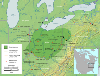
The Ohio Country, was a name used for a loosely defined region of colonial North America west of the Appalachian Mountains and south of Lake Erie.

The following is an alphabetical list of articles related to the U.S. state of Ohio.

The following outline is provided as an overview of and topical guide to the U.S. state of Illinois:

The following outline is provided as an overview of and topical guide to the U.S. state of Indiana:

The following outline is provided as an overview of and topical guide to the United States Commonwealth of Kentucky:

The following outline provides an overview of and topical guide to the U.S. state of Michigan:

The following outline is provided as an overview of and topical guide to the U.S. state of Minnesota:

The following outline is provided as an overview of and topical guide to the U.S. State of New York:

The following outline is provided as an overview of and topical guide to the United States Commonwealth of Pennsylvania:

The following outline is provided as an overview of and topical guide to South Carolina:

The following outline is provided as an overview of and topical guide to Tennessee:

The following outline is provided as an overview of and topical guide to the U.S. state of Virginia:

The following outline is provided as an overview of, and a topical guide to, the U.S. state of Wisconsin:
Robert Richard Oliver was a lieutenant colonel in the American Revolutionary War and a representative and president of the council of the Northwest Territory's first general assembly.